Items Similar to Eason's War Map of Europe, circa 1914


Want more images or videos?
Request additional images or videos from the seller
1 of 7
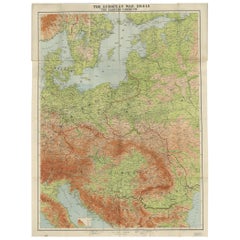
Eason's War Map of Europe, circa 1914
About the Item
Antique map titled 'Eason's War Map of Europe'. Printed in Ireland. Source unknown, to be determined.
Artists and Engravers: Anonymous.
Condition: Good, age-related toning. Minor defects, please study image carefully.
Date: circa 1914
Overall size: 62 x 47.5 cm.
Image size: 57 x 39 cm.
We sell original antique maps to collectors, historians, educators and interior decorators all over the world. Our collection includes a wide range of authentic antique maps from the 16th to the 20th centuries. Buying and collecting antique maps is a tradition that goes back hundreds of years. Antique maps have proved a richly rewarding investment over the past decade, thanks to a growing appreciation of their unique historical appeal. Today the decorative qualities of antique maps are widely recognized by interior designers who appreciate their beauty and design flexibility. Depending on the individual map, presentation, and context, a rare or antique map can be modern, traditional, abstract, figurative, serious or whimsical. We offer a wide range of authentic antique maps for any budget.
- Dimensions:Height: 18.71 in (47.5 cm)Width: 24.41 in (62 cm)Depth: 0 in (0.01 mm)
- Materials and Techniques:
- Period:
- Date of Manufacture:c.1914
- Condition:Condition: Good, age-related toning. Minor defects, please study image carefully.
- Seller Location:Langweer, NL
- Reference Number:
About the Seller
5.0
Platinum Seller
These expertly vetted sellers are 1stDibs' most experienced sellers and are rated highest by our customers.
Established in 2009
1stDibs seller since 2017
1,916 sales on 1stDibs
Typical response time: <1 hour
- ShippingRetrieving quote...Ships From: Langweer, Netherlands
- Return PolicyA return for this item may be initiated within 14 days of delivery.
More From This SellerView All
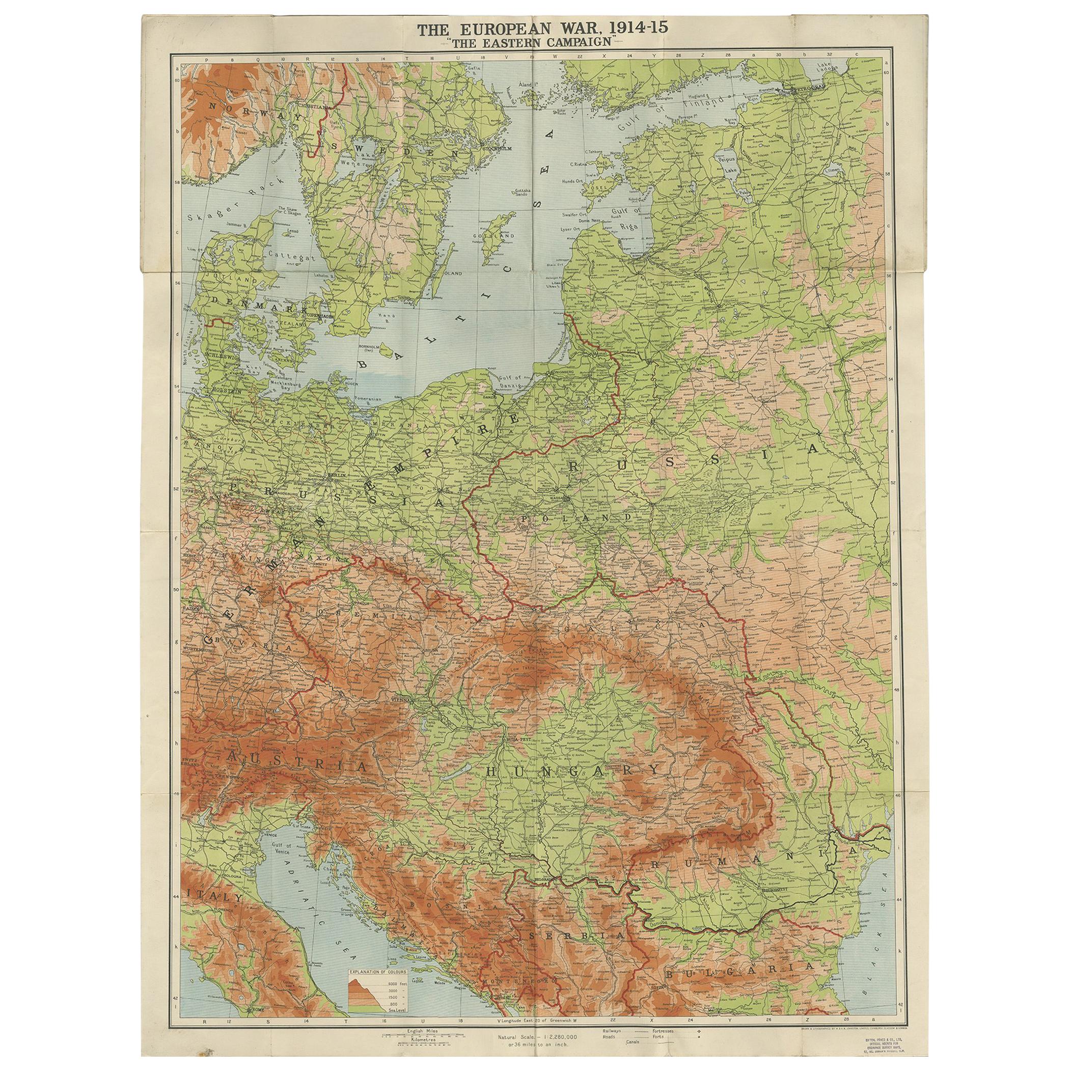
- Antique European War Folding Map, ‘circa 1915’Located in Langweer, NLAntique folding map of the European War (1914-1915) titled 'The Eastern Campaign '. From Petrograd to Berlin, geographically colored. Published on linen b...Category
Early 20th Century Maps
MaterialsPaper
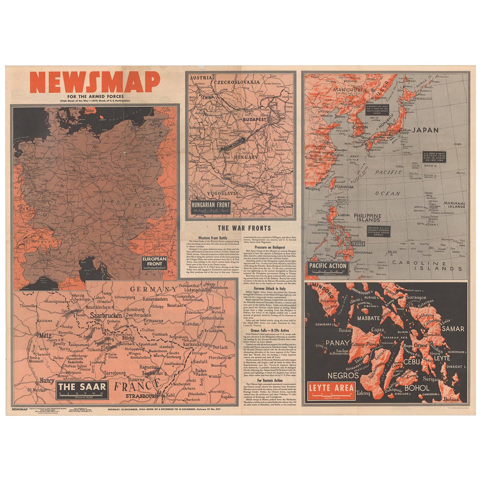
- Antique Map of the War Situation in Europe and Asia, 1944Located in Langweer, NLAntique map titled 'Newsmap for the Armed Forces'. This "newsmap" was issued on Monday, December 18, 1944, and covers the news from December 6-13, 1945 - the 275th week of the war. T...Category
20th Century Maps
MaterialsPaper
- Antique Map of Europe by Hederichs, circa 1740Located in Langweer, NLAntique map titled 'Europa Christiani Orbis Domina'. Rare miniature map of Europe. This map originates from 'Anleitung Zu den fürnehmsten Historischen Wissenschaften, Benanntlich Der...Category
Antique Mid-18th Century Maps
MaterialsPaper
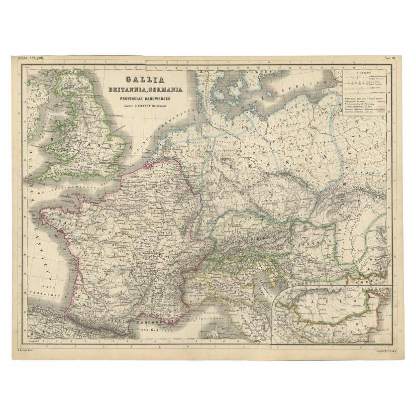
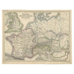
- Original Antique Map of West Europe, circa 1870Located in Langweer, NLAntique map titled 'Gallia, Britannia, Germania'. Old map of West Europe including France, Germany and the United Kingdom. This map originates from 'Atlas Antiquus, twaalf kaarten be...Category
Antique 19th Century Maps
MaterialsPaper
- Antique Map of Western Europe by H. Kiepert, circa 1870By Heinrich KiepertLocated in Langweer, NLAntique map titled 'Gallia, Britannia, Germania'. This map depicts a large part of Western Europe including countries like Germany, France, Great Britain, The Netherlands and more. T...Category
Antique Late 19th Century Maps
MaterialsPaper
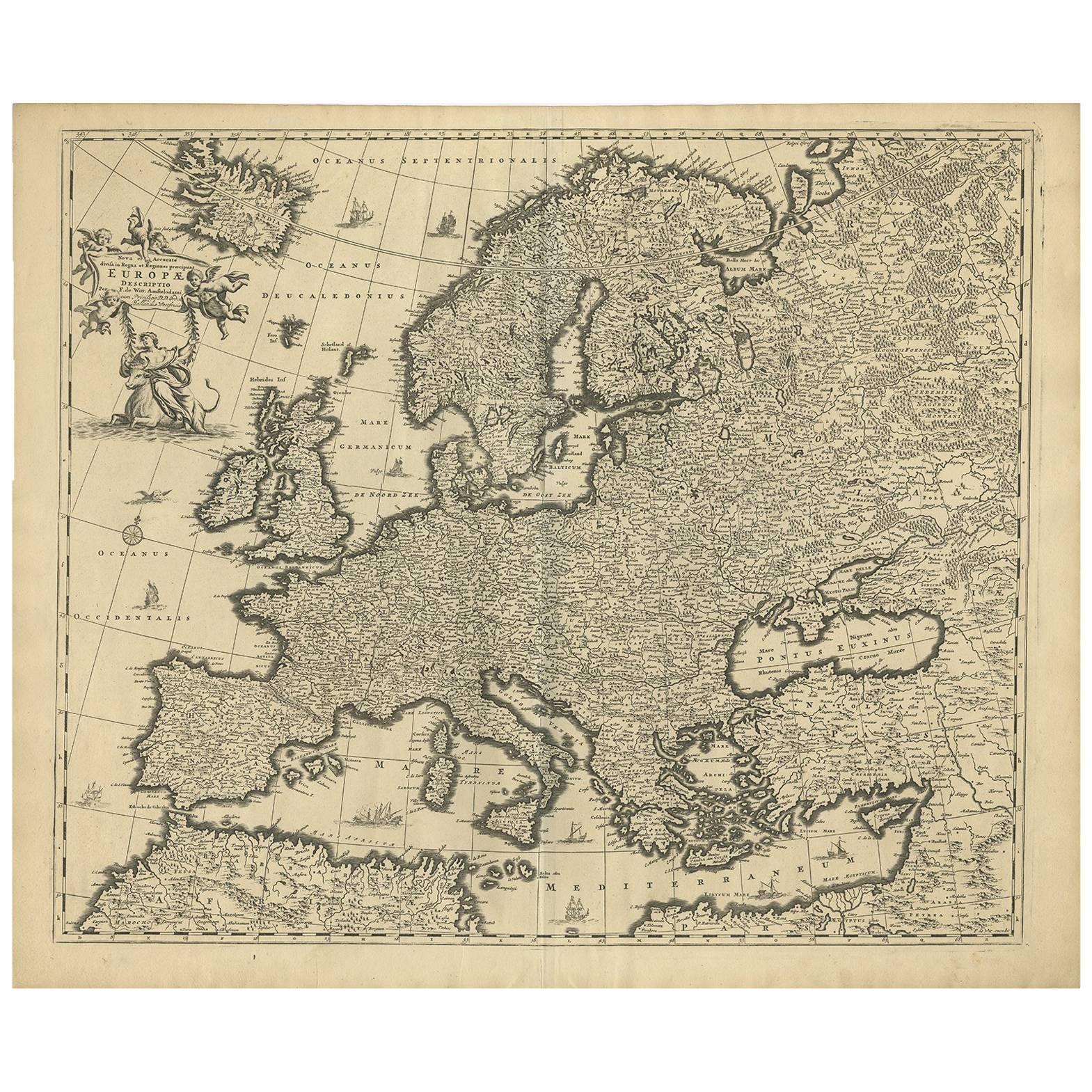
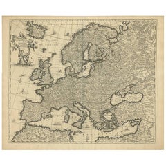
- Antique Map of Europe by F. de Wit, circa 1690Located in Langweer, NLAn attractive map of all Europe by Frederick de Wit. This detailed map has a decorative cartouche featuring the figure of "Europa" sitting on a bull.Category
Antique Late 17th Century Maps
MaterialsPaper


You May Also Like
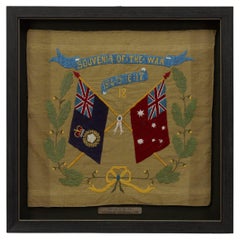
- Souvenir of the War 1914-15-16-17-18 BannerLocated in Colorado Springs, COPresented is a stunning textile banner from the first World War, dating to 1918. The square tan cotton cloth is embroidered with two crossed flags, the ...Category
Vintage 1910s Australian Political and Patriotic Memorabilia
MaterialsCotton
- Original Antique Map of Europe, Arrowsmith, 1820Located in St Annes, LancashireGreat map of Europe Drawn under the direction of Arrowsmith. Copper-plate engraving. Published by Longman, Hurst, Rees, Orme and Brown, 1820 ...Category
Antique 1820s English Maps
MaterialsPaper
- Antique Hand Colored Framed Map of EuropeLocated in West Palm Beach, FLAntique reproduction copied from an edition dated 1595 by Ortelius.Category
Antique Late 19th Century Maps
- 1849 Map of "Europaische Russland", 'Meyer Map of European Russia', Ric. R017Located in Norton, MA1849 Map of "Europaische Russland" ( Meyer Map of European Russia) Ric.r017 A lovely map of European Russia dating to 1849 by Joseph Meyer. It covers the European portions of...Category
Antique 19th Century Unknown Maps
MaterialsPaper
- Set of 4 Antique Geographical Maps French-German War 1870-71Located in Casale Monferrato, ITElegant late 19th century set of four antique geographical maps relating to the positioning of the armies in the Franco-German War 1870-71. A...Category
Antique 1890s Italian Maps
MaterialsPaper
- 17th Century Nicolas Visscher Map of Southeastern EuropeLocated in Hamilton, OntarioA beautiful, highly detailed map of southeastern Europe by Nicolas Visscher. Includes regions of Northern Italy (showing the cities Bologna, Padua, and Venice), Bohemia, Austria (sho...Category
Antique 17th Century Dutch Maps
MaterialsPaper


Recently Viewed
View AllMore Ways To Browse
Cambodia Antique Map
Antique Map Singapore
Guyana Antique Map
Antique Map Vietnam
Antique Maps Michigan
Puerto Rico Map
Wisconsin Map
Antique Map Sydney
Antique Maps Sydney
J Beringer
Antique Map Of Michigan
Antique Wisconsin Maps
Bedfordshire Antique Map
Herefordshire Antique Map
Antique Furniture Pondicherry
Antique Indiana Map
Antique Maps Rhode Island
Buckinghamshire Antique Map