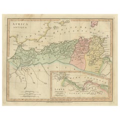
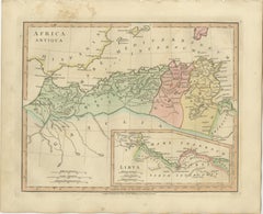
Africa Antiqua Antique Classical Map — Roman North Africa & Carthage, 1817
This finely engraved antique map titled Africa Antiqua presents a classical representation of North Africa as understood through ancient Greek and Roman geographic traditions. Published in London in 1827 by Wilkinson as part of the influential Atlas Classica, the map reflects early nineteenth-century scholarly attempts to reconstruct the ancient world through classical texts and historical geography.
The composition focuses on the Mediterranean coastline of North Africa from the Strait of Gibraltar eastward through Mauretania, Numidia, Africa Proconsularis, Cyrenaica, and Egypt. Regions such as Hispania across the Mediterranean, Carthage and its surrounding territories, and the Atlas mountain ranges provide broader geographic context, illustrating the interconnected nature of the ancient Mediterranean world. Numerous classical place names and provincial divisions appear throughout, offering insight into Roman administrative geography and the cultural landscape of antiquity.
Rendered in delicate copperplate engraving with original period hand coloring, the map displays refined linework and elegant typography characteristic of early nineteenth-century London atlas production. The restrained pastel palette enhances clarity while maintaining a sophisticated aesthetic suitable for both scholarly reference and decorative display.
Maps depicting classical North Africa hold strong appeal among collectors for their intersection of Roman history, ancient trade routes, and Mediterranean cultural exchange. As part of Wilkinson’s Atlas Classica series, this example pairs beautifully with related plates illustrating the classical world, ancient Egypt, and biblical geography, making it particularly desirable within a curated thematic grouping.
The wide horizontal format provides excellent wall presence and works especially well within gallery-style arrangements or academic interiors.
Condition report: Good condition for age. Light age toning and occasional minor foxing typical of early nineteenth-century paper. Marginal wear consistent with atlas removal. Original hand color remains fresh and attractive.
Framing tips: A dark walnut or ebonized frame with a generous ivory or warm-neutral mat emphasizes the classical palette and enhances readability while maintaining a refined museum-quality presentation.
Technique: Copperplate engraving with original hand color
Maker: Wilkinson, London, 1827
Important places and themes visible on the map:
Africa Antiqua, ancient North Africa map...
Category
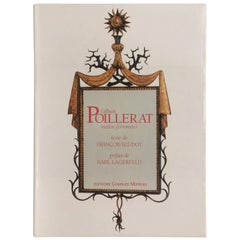
Early 19th Century British Antique François Baudot Furniture