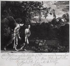
Tobias and the Angel
By Hendrik Goudt
Located in Chicago, IL
References: Bartsch, Dutuit and Hollstein 2
Category
17th Century Old Masters Hendrik Goudt Art
Materials
Engraving
Tobias and the Angel
By Hendrik Goudt
Located in Chicago, IL
References: Bartsch, Dutuit and Hollstein 2
Engraving

$375
H 13.63 in W 21.25 in
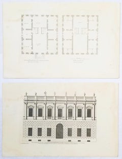
Set of Two Engravings from Campbell's "Vitruvius Britannicus" /// Architecture
By Colen Campbell
Located in Saint Augustine, FL
Artist: Colen Campbell (Scottish, 1676-1729) Titles: "The Plan of this New Design to the Earl of Islay" (Vol. 1, Plate 53) and "This New Design to the Earl of Islay" (Vol. 1, Plate 5...
Engraving, Laid Paper, Etching, Intaglio
$600
H 20.75 in W 15.5 in
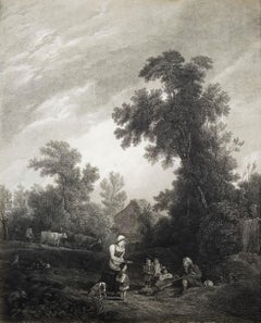
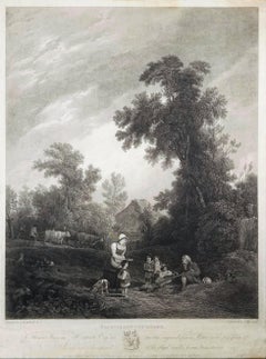
Benevolent Cottagers /// English Landscape Figurative Village Scene Engraving
Located in Saint Augustine, FL
Artist: (after) Sir Augustus Wall Callcott (English, 1779-1844) Title: "Benevolent Cottagers" Year: 1816 Medium: Original Etching and Engraving on laid paper Limited edition: Unknown...
Engraving, Etching, Laid Paper, Intaglio
$350
H 13 in W 9.25 in
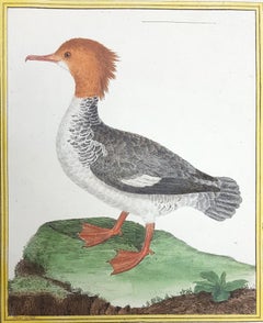
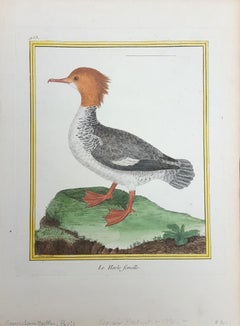
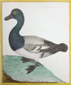
Le Harle Femell (The Female Merganser) /// Ornithology Martinet Bird Animal Art
By François Nicolas Martinet
Located in Saint Augustine, FL
Artist: François-Nicolas Martinet (French, 1731-1800) Title: "Le Harle Femell (The Female Merganser)" (Plate 953) Portfolio: Histoire Naturelle Des Oiseaux *Signed by Martinet in the...
Intaglio, Engraving, Laid Paper, Watercolor
$480
H 11.25 in W 18.25 in
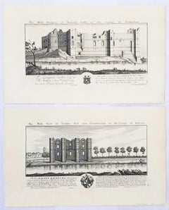
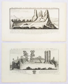
"Torksey Hall" and "Newark Castle" from "Buck's Antiquities" /// Architecture UK
By Samuel & Nathaniel Buck
Located in Saint Augustine, FL
Artist: Samuel and Nathaniel Buck (English, 1696-1779) and (?-1759/1774) Title: "Torksey Hall" (Plate 179) and "Newark Castle" (Plate 226) Portfolio: Buck's Antiquities or Venerable ...
Laid Paper, Engraving, Intaglio
$1,400Sale Price|30% Off
H 13.75 in W 9.88 in
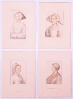
Set of Four Stipple Engravings from "Drawings by Hans Holbein" /// Henry VIII
By Hans Holbein
Located in Saint Augustine, FL
Artist: (after) Hans Holbein (the Younger) (German-Swiss, c. 1497-1543) Titles: "Jane Seymour Queen", "The Lady Mary after Queen", "Catherine Howard Q...
Engraving, Intaglio
$600
H 20.69 in W 13.5 in
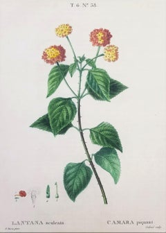
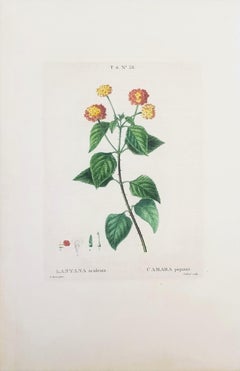
Lantana aculeata (Common Lantana) /// Pancrace Bessa Flower Plant Botanical Art
Located in Saint Augustine, FL
Artist: (after) Pancrace Bessa (French, 1772-1846) Title: "Lantana aculeata (Common Lantana)" (T.6. No. 38) Portfolio: Traité des Arbres et Arbustes que l'on Cultive en France en Ple...
Watercolor, Engraving
$480Sale Price|20% Off
H 11.07 in W 18.25 in
"Conisborough Castle" and "Morlashe Castle" from "Buck's Antiquities" /// UK Art
By Samuel & Nathaniel Buck
Located in Saint Augustine, FL
Artist: Samuel and Nathaniel Buck (English, 1696-1779) and (?-1759/1774) Title: "Conisborough Castle" (Plate 323) and "Morlashe Castle" (Plat...
Laid Paper, Engraving, Intaglio
$250
H 10.25 in W 8 in
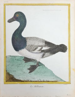
Le Millouinan /// Ornithology Martinet Bird Animal Art Duck Natural History
By François Nicolas Martinet
Located in Saint Augustine, FL
Artist: François-Nicolas Martinet (French, 1731-1800) Title: "Le Millouinan" (Plate 1002) Portfolio: Histoire Naturelle Des Oiseaux *Signed by Martinet in the plate (printed signatur...
Intaglio, Engraving, Laid Paper, Watercolor
$250
H 12 in W 8.75 in
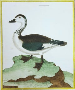
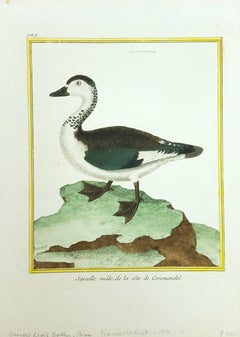
Sacelle male, de la cote de Coromandel /// Ornithology Martinet Bird Animal Art
By François Nicolas Martinet
Located in Saint Augustine, FL
Artist: François-Nicolas Martinet (French, 1731-1800) Title: "Sacelle male, de la cote de Coromandel" (Plate 949) Portfolio: Histoire Naturelle Des Oiseaux *Signed by Martinet in the...
Watercolor, Laid Paper, Engraving, Intaglio
$450
H 18.5 in W 13.63 in
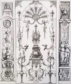
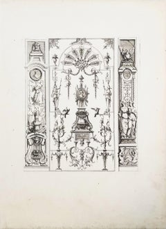
Untitled /// French Ornaments Designs Architecture Jean Bérain Old Master Print
By Jean Bérain
Located in Saint Augustine, FL
Artist: Jean Berain (the Elder) (French, 1640-1711) Title: "Untitled" (Plate 35) Portfolio: Ornemens Inventez par J. Berain (Ornament Designs Invented by J. Berain) Circa: 1711 (Firs...
Laid Paper, Engraving, Intaglio, Etching
$900
H 21.44 in W 13.75 in
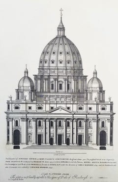
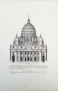
St Peters Church at Rome /// "Vitruvius Britannicus" Architecture Engraving Art
By Colen Campbell
Located in Saint Augustine, FL
Artist: Colen Campbell (Scottish, 1676-1729) Title: "St Peters Church at Rome" (Vol. 1, Plate 6) Portfolio: Vitruvius Britannicus; or The British Architect, Containing the Plans, Ele...
Laid Paper, Engraving, Etching, Intaglio
$1,200
H 16.5 in W 22.5 in
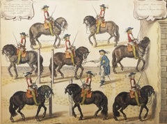
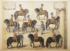
Captain Mazin Rides, and the Marquis Gives the Lesson /// Equestrian Horse Art
By William Cavendish
Located in Saint Augustine, FL
Artist: William Cavendish (English, 1593-1676) Title: "Captain Mazin Rides, and the Marquis Gives the Lesson" (Plate 17, Page 76) Portfolio: Methode et Invention Nouvelle de Dresser ...
Intaglio, Etching, Engraving, Laid Paper, Watercolor