
Joan (Johannes) Blaeu Art

to
3
4
3
7
7
6
2
Antique Map of Cheshire, North West England
By Joan (Johannes) Blaeu
Located in Langweer, NL
Antique map titled 'Cestria comitatus Palatinus'. Original old map of Cheshire, Northwest England. Published circa 1665 by J. Blaeu. Willem Jansz. Blaeu and his son Joan Blaeu are th...
Category

Mid-17th Century Antique Joan (Johannes) Blaeu Art

Materials

Paper

Antique Map of Berkshire, South East England
By Joan (Johannes) Blaeu
Located in Langweer, NL
Antique map titled 'Bercheria vernacule Barkshire'. Original old map of Berkshire, a historic county in South East England. Published circa 1665 by J. Blaeu. Willem Jansz. Blaeu and ...
Category

Mid-17th Century Antique Joan (Johannes) Blaeu Art

Materials

Paper

Map of Oxfordshire by Joan Blaeu with college crests
By Joan (Johannes) Blaeu
Located in London, GB
To see our other original maps, scroll down to "More from this Seller" and below it click on "See all from this Seller" - or send us a message if you cannot find the poster you want....
Category

1660s Joan (Johannes) Blaeu Art

Materials

Engraving

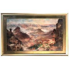
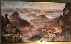
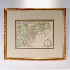
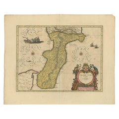
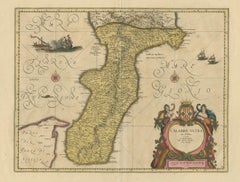
Cadiz Island: A Framed 17th Century Hand-colored Map from Blaeu's Atlas Major
By Joan (Johannes) Blaeu
Located in Alamo, CA
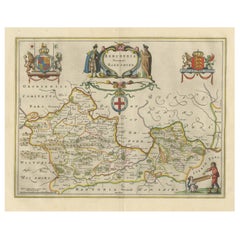
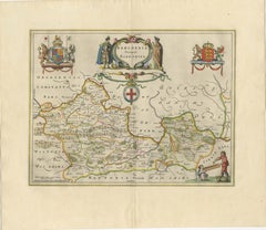
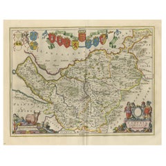
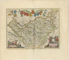
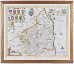
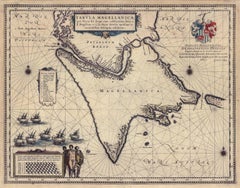
This is a 17th century hand-colored map entitled "Insula Gaditana Isla de Cadiz" from Johannes (Joan) Blaeu's Atlas Maior, published in Amsterdam in 1662. The map provides an excellent plan of Cadiz Island on the southwest coast of Spain, with its harbor, fortifications, agricultural fields and several surrounding salt processing areas. Numerous sailing ships of various sizes are included in and around the harbor and bay, including five large sailing ships, as well as twenty-four smaller ships. There is a small compass rose overlying the bay. The bridge to the mainland from the island is shown on the right. There is an extremely ornate and colorful title cartouche in the lower left, with its mythological figures reminiscent of Raphael’s Galatea fresco at the Villa Farnesina in Rome. The vibrant colors are vividly preserved. The master colorist tried to emulate a painting by using various tones to create a three-dimensional effect.
 Blaeu's name is present in the plate in the lower right. Blaeu stated in his description of Cadiz: “The main wealth of the islanders consists of salt, which they harvest, and
 the tuna fisheries.” 
 This 17th century hand-colored map is framed in an ornate, partially textured bronze-colored wood frame and glazed with UV protected conservation glass. There is a vertical center fold, as issued. There is a faint crease in the lower right and faint color offset on the left from the right side of the map, resulting from having been in an atlas for hundreds of years. Small foci of paint are present in the upper portion of the left margin and in the left corner margin. The map is otherwise in very good condition. Due in large part to their powerful trade empire, the Dutch became known for cartography in the seventeenth century. This period is considered the Golden Age of Dutch cartography. Their publishing houses produced the highest quality work in Europe, particularly those maps and charts of foreign lands, and Dutch map-making set the bar for cartographic accuracy and artistry into the early-eighteenth century. Some of the most well-known cartographers worked in Amsterdam during this period. Perhaps the most famous of these was the Blaeu family. Willem Janszoon Blaeu, set up shop in Amsterdam. His son, Johannes (Joan), succeeded him upon his death in 1638, continuing in his father’s position as Hydrographer to the Dutch East India Company and selling maps to the public. The Blaeu map presses, located near Amsterdam’s Dam Square...
Category

Mid-17th Century Old Masters Joan (Johannes) Blaeu Art

Materials

Engraving

17th Century Italian Gravure, Theatrum Statuum Sabaudiae, circa 1682
By Joan (Johannes) Blaeu
Located in Miami, FL
17th century Italian Gravure/Cartography Le Theatrum statuum Regiae Celsitudinis Sabaudiæ Ducis or at Theatrum Statum Sabaudiæ, is a representative and iconographic representation f...
Category

17th Century Italian Antique Joan (Johannes) Blaeu Art

Materials

Paper

Map of Northumberland by Joan Blaeu
By Joan (Johannes) Blaeu
Located in London, GB
To see our other original maps, scroll down to "More from this Seller" and below it click on "See all from this Seller" - or send us a message if you cannot find the poster you want....
Category

1660s Joan (Johannes) Blaeu Art

Materials

Engraving

Tabula Magellanica, qua Tierra del fuego, cum celeberrimis fretis a F. Magellano
By Joan (Johannes) Blaeu
Located in New York, NY
This mid 17th-century map was published by Guiljelmum Blaeu in Amsterdam. The engraved map is 16 1/8 x 21" (41 x 53.1 cm) with beautiful original hand color. Tabula Magellanica is a highly decorative map of the southern tip of South America, including Tierra del Fuego...
Category

Mid-17th Century Other Art Style Joan (Johannes) Blaeu Art

Materials

Engraving

Related Items
Antique Map of Principality of Monaco
By Antonio Vallardi Editore
Located in Alessandria, Piemonte
ST/619 - "Old Geographical Atlas of Italy - Topographic map of ex-Principality of Monaco" - ediz Vallardi - Milano - A somewhat special edition ---  
Category

Late 19th Century Italian Other Antique Joan (Johannes) Blaeu Art

Materials

Paper

Antique Map of Principality of Monaco
$442
H 22.84 in W 15.75 in D 0.04 in
North & South America: A 17th Century Hand-colored Map by Jansson & Goos
By Johannes Janssonius
Located in Alamo, CA
A 17th century hand-colored map of North & South America entitled "Americae Descriptio" by the cartographer Johannes Jansson, published in Jansson's Atlas Minor in Amsterdam in 1628....
Category

1620s Dutch Antique Joan (Johannes) Blaeu Art

Materials

Paper

Large 17th Century Hand Colored Map of England and the British Isles by de Wit
By Frederick de Wit
Located in Alamo, CA
A large hand colored 17th century map of England and the British Isles by Frederick de Wit entitled "Accuratissima Angliæ Regni et Walliæ Principatus", published in Amsterdam in 1680. It is a highly detailed map of England, Scotland, the Scottish Isles...
Category

Late 17th Century Dutch Antique Joan (Johannes) Blaeu Art

Materials

Paper

Plan of the Park, Garden and Plantations of Goodwood, 18th century engraving
By Colen Campbell
Located in Melbourne, Victoria
Plan of the Park, Garden and Plantations of Goodwood in Sussex the Seat of his Grace the Duke of Richmond and Lenox &c Copper-line engraving with later hand-colouring by Hendrik Hul...
Category

18th Century English School Joan (Johannes) Blaeu Art

Materials

Engraving

Carte Particuliere Des Coste De Bretagne qui Comprend Morlaix
By Pierre Mortier
Located in Paonia, CO
Carte Particuliere Des Costes De Bretagne qui Comprend Morlaix, Saint Paul de Leon, les Sept Isles, et L’Isle. Faite par ordre Exprez Du Roy de France is from the collection of ch...
Category

1690s Joan (Johannes) Blaeu Art

Materials

Engraving

Lafitte's Blacksmith House (a bar named for a pirate on Bourbon St, New Orleans)
By Frederick Mershimer
Located in New Orleans, LA
Lafitte's Blacksmith Shop is a New Orleans landmark at 941 Bourbon St. Like most New Orleans legends, history of Lafitte's Blacksmith Shop is a gumbo of tru...
Category

Early 2000s Contemporary Joan (Johannes) Blaeu Art

Materials

Mezzotint, Aquatint

Here They Come !
By Frank W. Benson
Located in New York, NY
This impression of "Here They Come !" is from the fourth state of eight. There are six known impressions of the fourth state. Edition 150 (final state). It is signed in pencil in the lower left and inscribed "D-1". The image size 13 7/8 x 11 3/4" (34.6 x 28.8 cm) and sheet size 16 3/4 x 14 5/8" (42.8 x 37.1 cm). FRANK W. BENSON (1862-1951) Frank Weston Benson, well known for his American impressionist paintings, also produced an incredible body of prints - etchings, drypoints, and a few lithographs. Born and raised on the North Shore of Massachusetts, Benson, a natural outdoorsman, grew up sailing, fishing, and hunting. From a young age, he was fascinated with drawing and birding – this keen interest continued throughout his life. His first art instruction was with Otto Grundman at the Museum of Fine Arts in Boston, and then in 1883 in Paris at the Academie Julian where he studied the rigorous ‘ecole des beaux arts’ approach to drawing and painting for two years. During the early 1880’s Seymour Haden visited Boston giving a series of lectures on etching. This introduction to the European etching...
Category

1920s American Impressionist Joan (Johannes) Blaeu Art

Materials

Drypoint

Original Antique Map of Spain and Portugal, circa 1790
Located in St Annes, Lancashire
Super map of Spain and Portugal Copper plate engraving by A. Bell Published, circa 1790. Unframed.  
Category

1790s English Other Antique Joan (Johannes) Blaeu Art

Materials

Paper

Foggy Night (the way home or a Stephen King setting)
By Carol Wax
Located in New Orleans, LA
This impression is #22 Carol Wax originally trained to be a classical musician at the Manhattan School of Music but fell in love with printmaking. Soon after she began engraving mezzotints she was asked by the renowned print dealer Sylvan Cole to exhibit at Associated American Artists Gallery, launching her career as a professional artist/printmaker. With the publication of her book, The Mezzotint: History and Technique, published by Abrams, 1990 and 1996, Carol added author and teacher to her credits. In the ensuing years she has expanded her repertoire of mediums beyond printmaking into other works on paper and painting. In compositions reflecting an appreciation for antiquated machinery and vintage textiles, Wax creates imagery that, in her own words, “… speaks to an inner life perceived in inanimate objects.” She uses stylization and imagination to reinvent subjects, transforming an ordinary typewriter into a monumental icon...
Category

2010s American Modern Joan (Johannes) Blaeu Art

Materials

Engraving, Mezzotint

Island of Philae, Egypt. Early 19th century engraving, 1820
Located in Melbourne, Victoria
'Ile de Philae : Vue de l'edifice de l'est et de plusieurs monuments' (Island of Philae : View of the east building and other monuments) Elephant folio engraving, by Baltard after...
Category

Early 19th Century Other Art Style Joan (Johannes) Blaeu Art

Materials

Engraving

New Map of North America from the Latest Discoveries, 1763
Located in Philadelphia, PA
A fine antique 18th century map of the North American seaboard. Entitled "A New Map of North America from the Latest Discoveries 1763". By the Cartographer/Engraver - John Spil...
Category

Mid-18th Century English Georgian Antique Joan (Johannes) Blaeu Art

Materials

Paper

COLMAR Signed Wood Engraving, French Village, Little Venice Half-Timbered Houses
By Bernard Brussel-Smith
Located in Union City, NJ
COLMAR is an original wood engraving by the American artist Bernard Brussel-Smith, hand printed in yellow, light blue and black ink. COLMAR depicts a quaint French village scene with...
Category

1970s Realist Joan (Johannes) Blaeu Art

Materials

Engraving

Previously Available Items
Antique Map of Persia, Also Showing the Indus River, circa 1673
By Joan (Johannes) Blaeu
Located in Langweer, NL
Antique map titled 'Persia sive Sophorum Regnum'. Original old map of Persia. The map extends from the Eastern Mediterranean to Tacalistan and the Indus River and the Dalanguer Mount...
Category

Late 17th Century Antique Joan (Johannes) Blaeu Art

Materials

Paper

Set of World & Four Continents
By Joan (Johannes) Blaeu
Located in London, GB
BLAEU, Johannes. [Set of World & Four Continents from the 'Atlas Major'] Nova et Accuratissima Totius Terrarum Orbis Tabula; Americæ nova Tabula; Asia noviter delineata; Africæ nova descriptio; Europa recens descripta. Amsterdam, n.d. [c. 1650]. Set of 5 hand-coloured double-page engraved maps, centre fold as issued, with cartouches for the titles and dedication, Latin text on verso; sheet size: 49 x 60 cm. Framed and glazed, overall size: 61 x 75 x 2 cm. A fine set of five maps from the most expensive book published in the 17th century, an eleven-volume atlas containing 593 hand-coloured maps. The highly decorative borders have allegorical figures of the known planets along the top, lateral borders of the Four Elements and the Four Seasons, and the Seven Wonders of the Ancient World along the bottom. Each of the continents has lateral borders of native dress and nine city prospects along the top. Blaeu's set of the World & Continents are perhaps the most decorative and cartographically accurate of all sets published in the 17th Century. Blaeu's work set the standard for other map makers during the Golden Age of Cartography, characterised by fine engraving, high quality paper and fine geographical detail. His map of the world is one of the earliest maps to utilize the Mercator Projection, which allowed mariners in the open sea to make practical use of maps. The map of the World is embellished with allegorical representations of the 4 seasons and 4 elements in the side panels, the 7 wonders of the Ancient World at the bottom and representations of the Classical Planets, moon and sun at the top. The maps of the 4 continents...
Category

17th Century Joan (Johannes) Blaeu Art

Materials

Watercolor, Engraving

AYX Map of Aix en Provence, France by J. Blaeu 17th c.
By Joan (Johannes) Blaeu
Located in Paonia, CO
Detailed plan of Aix en Provence, in France. This print is a hand -colored double sheet engraving by the famous cartographer Joan (Johannes) Blaeu ( 1596 - 1673 ). The left side ...
Category

Late 17th Century Other Art Style Joan (Johannes) Blaeu Art

Materials

Engraving

Antique Map of Calabria 'Italy' by Blaeu, circa 1690
By Joan (Johannes) Blaeu
Located in Langweer, NL
Antique map titled 'Calabre Ultra'. Beautiful and rare map of Calabria, Italy. Calabria, known in antiquity as Bruttium, is a region in Southern Italy. Very decorative example with o...
Category

Late 17th Century Antique Joan (Johannes) Blaeu Art

Materials

Paper

Joan (johannes) Blaeu art for sale on 1stDibs.

Find a wide variety of authentic Joan (Johannes) Blaeu art available for sale on 1stDibs. You can also browse by medium to find art by Joan (Johannes) Blaeu in engraving, paint, watercolor and more. Much of the original work by this artist or collective was created during the 18th century and earlier and is mostly associated with the Old Masters style. Not every interior allows for large Joan (Johannes) Blaeu art, so small editions measuring 20 inches across are available. Customers who are interested in this artist might also find the work of Stefano Della Bella, Karel Dujardin, and Gerard Mercator. Joan (Johannes) Blaeu art prices can differ depending upon medium, time period and other attributes. On 1stDibs, the price for these items starts at $956 and tops out at $37,587, while the average work can sell for $1,150.

Artists Similar to Joan (Johannes) Blaeu

Giovanni Benedetto Castiglione
Giovanni Battista Piranesi

Recently Viewed

View All