20th Century Maps
to
232
415
56
473
15
6
4
4
3
2
2,974
2,230
473
3
288
34
9
126
8
36
9
2
5
4
3
2
435
27
20
19
12
109
86
70
42
32
473
473
473
5
2
2
1
1
Period: 20th Century
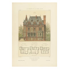
Antique Print of the Villa Salamandre in France, Chabat, c.1900
Located in Langweer, NL
Antique print titled 'Villa Salamandre Houlgate (Calvados) Mr. Baumier Architecte'. This print depicts the design of a building in France. Originates from 'La Brique et La Terre Cuit...
Category
20th Century Maps
Materials
Paper
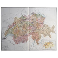
Large Original Vintage Map of Switzerland, circa 1920
Located in St Annes, Lancashire
Great map of Switzerland
Original color.
Good condition
Published by Alexander Gross
Unframed.
Category
English Vintage 20th Century Maps
Materials
Paper
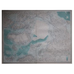
Large Original Vintage Map of The North Pole, circa 1920
Located in St Annes, Lancashire
Great maps of The North Pole.
Unframed.
Original color.
By John Bartholomew and Co. Edinburgh Geographical Institute.
Published, circa 1920.
Free shipp...
Category
British Vintage 20th Century Maps
Materials
Paper
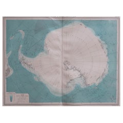
Large Original Vintage Map of the South Pole, circa 1920
Located in St Annes, Lancashire
Great map of the South pole.
Unframed.
Original color.
By John Bartholomew and Co. Edinburgh Geographical Institute.
Published, circa 1920.
Category
British Vintage 20th Century Maps
Materials
Paper
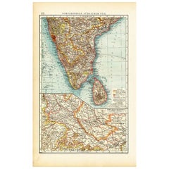
Antique Map of Southern India by Andree, 1904
Located in Langweer, NL
"Antique map titled 'Vorderindien, sudlicher Teil'. Map of India, southern part. This map originates from 'Andrees Allgemeiner Handatlas in 126 Haupt-Und 139 Nebenkarten', Bielefeld;...
Category
20th Century Maps
Materials
Paper
$68 Sale Price
20% Off
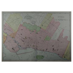
Large Original Antique City Plan of Montreal, Canada, circa 1900
Located in St Annes, Lancashire
Fabulous colorful map of Montreal
Original color
By Rand, McNally & Co.
Published, circa 1900
Unframed
Minor edge tears
Free shipping.
Category
American Antique 20th Century Maps
Materials
Paper
Antique Political Map of the Japanese Empire, 1922
Located in Langweer, NL
Antique map of Japan titled 'Japanese Empire - Political Map'. Old map of Japan depicting Japan, Korea and surroundings. This map originates from 'The Ti...
Category
20th Century Maps
Materials
Paper
Architectural Print of the French Villa Weber, Chabat, c.1900
Located in Langweer, NL
Antique print titled 'Villa Weber, Mr. Paul Sédille Architecte'. This print depicts the design of a building in France. Originates from 'La Brique et La Terre Cuite' by P. Chabat. Ar...
Category
20th Century Maps
Materials
Paper
Architectural Print of Villa Weber in France - Chabat, c.1900
Located in Langweer, NL
Antique print titled 'Villa Weber, Mr. Paul Sédille Architecte'. This print depicts the design of a building in France. Originates from 'La Brique et La Terre Cuite' by P. Chabat. Ar...
Category
20th Century Maps
Materials
Paper
Eason's War Map of Europe, circa 1914
Located in Langweer, NL
Antique map titled 'Eason's War Map of Europe'. Printed in Ireland. Source unknown, to be determined.
Artists and Engravers: Anonymous.
Condition: Good, ...
Category
20th Century Maps
Materials
Paper
$518 Sale Price
20% Off
Antique Map of Central Asia and India, 1904
Located in Langweer, NL
Antique map titled 'Zentralasien und Vorderindien'. Map of Central Asia and India. This large antique map is taken from; 'Andrees Allgemeiner Handatlas in 126 Haupt-Und 139 Nebenkart...
Category
20th Century Maps
Materials
Paper
$127 Sale Price
20% Off
Pl. LXXX Maison Rue de la Faisanderie Paris, Chabat, c.1900
Located in Langweer, NL
Antique print titled 'Maison Rue de la Faisanderie Paris, Mr. Sellier de Gisors Architecte'. This print depicts the design of a building in France. Originates from 'La Brique et La T...
Category
20th Century Maps
Materials
Paper
$117 Sale Price
20% Off
Large Original Vintage Map of the South Eastern States Inc. Florida, circa 1920
Located in St Annes, Lancashire
Great map of The South Eastern States
Original color. Good condition
Published by Alexander Gross
Unframed.
Category
English Vintage 20th Century Maps
Materials
Paper
Two Impressive Huge Midcentury World Map Wall Globes, 95" Diameter, 1950s
Located in Vienna, AT
We proudly offer this outstanding pair of very large wall-mounted modernist globes / world maps with an incredible diameter of 95 inches each. Unique one-of-a-kind sculptures depicti...
Category
Austrian Mid-Century Modern 20th Century Maps
Materials
Aluminum, Iron
Large Original Antique Map of Arkansas by Rand McNally, circa 1900
Located in St Annes, Lancashire
Fabulous monochrome map with red outline color
Original color
By Rand, McNally & Co.
Published, circa 1900
Unframed
Minor edge tears.
Category
American Edwardian Antique 20th Century Maps
Materials
Paper
Large Original Vintage Map of British Island Possessions, circa 1920
Located in St Annes, Lancashire
Great map of British Island Possessions
Original color. Good condition
Published by Alexander Gross
Unframed.
Category
English Vintage 20th Century Maps
Materials
Paper
French Architectural Print of Villa a Pont a Mousson, Chabat, c.1900
Located in Langweer, NL
Antique print titled 'Villa a Pont a Mousson, Mr. Pierre Chabat Architecte'. This print depicts the design of a building in France. Originates from 'La Brique et La Terre Cuite' by P...
Category
20th Century Maps
Materials
Paper
Vintage Barrister's Map of London, English, Framed, Inner, Middle Temple, C.1970
Located in Hele, Devon, GB
Our Stock # 24730
This is a vintage barrister's map of London. An English, annotated Inner and Middle Temple lithograph framed behind glass, dating to the late 20th century, circa 1...
Category
British Mid-Century Modern 20th Century Maps
Materials
Glass, Wood, Paper
Antique Map of the West Indies in Full Color, 1922
Located in Langweer, NL
Antique map titled 'The West Indies.' A map of the West Indies, the Carribean region. This includes the Greater Antilles (Jamaica, Haiti, Puerto Rico and Cuba) and the Lesser Antille...
Category
20th Century Maps
Materials
Paper
$132 Sale Price
20% Off
Antique Map of the United States ' South East ' by Johnston '1909'
Located in Langweer, NL
Antique map titled 'United States of North America'. Original antique map of United States of North America ( South East Sheet ). With in...
Category
20th Century Maps
Materials
Paper
$330 Sale Price
20% Off
Massive Vintage Wall Map of the Soviet Union 'Sowjetunion' by Karl Wenschow
Located in San Diego, CA
A massive vintage wall map of the Soviet Union (Sowjetunion) published by Karl Wenschow in Munich, Germany, circa 1950s. The map was distributed by De...
Category
American 20th Century Maps
Materials
Paper, Wood
$540 Sale Price
20% Off
Antique Map of the British Isles by Johnston '1909'
Located in Langweer, NL
Antique map titled 'The British Isles'. Original antique map of the British Isles. With inset maps of the Shetland Islands, Chanel Islands, and London. T...
Category
20th Century Maps
Materials
Paper
$235 Sale Price
20% Off
Antique Map of West Kalimantan (Schwaner Mountains), Borneo, Indonesia, 1900
Located in Langweer, NL
Antique map of West Kalimantan, Borneo. It shows the region of the Schwaner Mountains. This map originates from 'Atlas van Nederlandsch Oost- en West-Indië' by I. Dornseiffen.
Arti...
Category
20th Century Maps
Materials
Paper
$311 Sale Price
20% Off
Antique Map of Part of Java, Indonesia, 1900
Located in Langweer, NL
Antique map of West Java. This map originates from 'Atlas van Nederlandsch Oost- en West-Indië' by I. Dornseiffen.
Artists and Engravers: Published by Seyffardt's Boekhandel, Amste...
Category
20th Century Maps
Materials
Paper
$273 Sale Price
20% Off
Vintage Print of the Lady of Stavoren by Voskuijl, 1946
Located in Langweer, NL
Vintage lithograph titled 'Vrouwtje van Stavoren'. Lithograph of the Lady of Stavoren, a folk tale from the Netherlands which originated in the 16th century. Published 1946.
Arti...
Category
20th Century Maps
Materials
Paper
$273 Sale Price
20% Off
Pl. VI Habitations Ouvrières a Laeken, Chabat, c.1900
Located in Langweer, NL
Antique print titled 'Habitations Ouvrières a Laeken pour les ouvriers de l'usine a gaz de la Ville de Bruxelles, Mr. V. Jamaer, Architecte'. This print depicts the design of a buidl...
Category
20th Century Maps
Materials
Paper
$119 Sale Price
20% Off
Exploring South America's North: Antique Map from the Royal Atlas of 1909
Located in Langweer, NL
The antique map titled 'South America, Northern Sheet' is a historical cartographic representation of the northern part of South America. This original antique map features inset map...
Category
20th Century Maps
Materials
Paper
$235 Sale Price
20% Off
Large Wall Map of Europe by George Philip & Son, circa 1920
Located in Langweer, NL
Antique map titled 'Philips' New Commercial Map of Europe'. Very large wall map of Europe including the North African coast and Turkey. Decorative bord...
Category
20th Century Maps
Materials
Linen, Paper
$2,063 Sale Price
30% Off
Antique Map of the Region of Lampung, Sumatra, Indonesia, 1900
Located in Langweer, NL
Antique map of the region of Lampung, Sumatra. Also depicting part of Palembang and Java. This map originates from 'Atlas van Nederlandsch Oost- en West-Indië' by I. Dornseiffen.
A...
Category
20th Century Maps
Materials
Paper
Antique Folding Map of Kyoto, Japan, 1920
Located in Langweer, NL
Antique folding map of Kyoto, Japan. On the verso of this map photos of buildings, other structures and informative text can be found.
Category
20th Century Maps
Materials
Paper
German Antique Map of Southeastern Australia, 1904
Located in Langweer, NL
This large antique map is taken from; 'Andrees Allgemeiner Handatlas in 126 Haupt-Und 139 Nebenkarten', Bielefeld; Leipzig: Velhagen & Klasing 1899. Andrees Allgemeiner Handatlas was...
Category
20th Century Maps
Materials
Paper
$70 Sale Price
20% Off
Antique Map of the Region of Bussum, c.1910
Located in Langweer, NL
Antique map titled 'Bussum'. Map of the region of Bussum, the Netherlands. Published by the 'ANWB', circa 1910.
Artists and Engravers: Anonymous.
Condition: Fair/good, general...
Category
20th Century Maps
Materials
Paper
$80 Sale Price
20% Off
Large Original Vintage Map of New Zealand, South Island, circa 1920
Located in St Annes, Lancashire
Great map of South Island, New Zealand
Original color.
Good condition / repair to a minor tear on right edge
Published by Alexander Gross
Unframed.
Category
English Edwardian Vintage 20th Century Maps
Materials
Paper
Antique Map of the Region of the Nile River by Bartholomew, 1922
Located in Langweer, NL
Antique map of Africa titled 'Egypt and the Nile'. Old map of Africa depicting Egypt, the Nile river and surroundings. This map originates from 'The Times' ...
Category
20th Century Maps
Materials
Paper
$89 Sale Price
20% Off
Old French Architectural Print of École Nationale Professionnelle d'Armentières
Located in Langweer, NL
Antique print titled 'École Nationale Professionnelle d'Armentières Pavillon de l'Escalier, Mr. Charles Chipiez Architecte'. This print depicts the design o...
Category
20th Century Maps
Materials
Paper
Architectural Print of French Villa de la Hutte A Deauville by Chabat, c.1900
Located in Langweer, NL
Antique print titled 'Villa de la Hutte A Deauville, Mr. E. Saintin Architecte'. This print depicts the design of a building in France. Originates from 'La Brique et La Terre Cuite' ...
Category
20th Century Maps
Materials
Paper
Architectural Print of Ecuries Avenue Raphaël, Paris by Chabat, c.1900
Located in Langweer, NL
Antique print titled 'Ecuries Avenue Raphaël Paris, Mr. A. Feine Architecte'. This print depicts the design of a building in France. Originates from 'La Brique et La Terre Cuite' by ...
Category
20th Century Maps
Materials
Paper
Heliograph of Tin Mining in Tronoh, Perak and Tambun in Sabah, Malaysia, 1907
Located in Langweer, NL
Three views of the Mining Industry in Malaysia around 1907.
1. Lankshuts at Tronoh, Perak
2. Puddling Machinery, Tambun in Sabah
3. Shaking Machinery at Red Hill
This helio...
Category
Antique 20th Century Maps
Materials
Paper
$614 Sale Price
20% Off
Antique Map of Sulawesi by Winkler Prins, c.1900
Located in Langweer, NL
Antique map titled 'Celebes.' (Sulawesi .) This map shows the Indonesian island of Sulawesi, one of the Sunda islands. With inset maps of South-west Sulawesi and Semenanjung Minahassa. Legend and scale. This map originates from 'De Grote Winkler Prins...
Category
20th Century Maps
Materials
Paper
$68 Sale Price
20% Off
Architectural Print of French Pavillon de la Grande Tuilerie, Chabat, c.1900
Located in Langweer, NL
Antique print titled 'Pavillon de la Grande Tuilerie de Bourgogne (de Montghanin) Exposition Universelle de 1889, Mrs. Wulliam et Farge Architectes'. This print depicts the design of...
Category
20th Century Maps
Materials
Paper
Architectural Print From France of the Galerie des Machines, Chabat, c.1900
Located in Langweer, NL
Antique print titled 'Gallerie des Machines Exposition Universelle de 1889, Mr. F. Dufert Architecte'. This print depicts the design of a building in France. Originates from 'La Briq...
Category
20th Century Maps
Materials
Paper
Pl. XII Villa a Houlgate, Chabat, c.1900
Located in Langweer, NL
Antique print titled 'Villa a Houlgate Mr. E. Papinot Architecte'. This print depicts the design of a villa in France. Originates from 'La Brique et La Terre Cuite' by P. Chabat. Art...
Category
20th Century Maps
Materials
Paper
$117 Sale Price
20% Off
Antique Map of N.W. Africa & Central Africa by Johnston (1909)
Located in Langweer, NL
Antique map titled 'N.W. Africa & Central Africa'. Original antique map of N.W. Africa & Central Africa. This map originates from the ‘Royal Atlas of Modern Geography’. Published by ...
Category
20th Century Maps
Materials
Paper
$235 Sale Price
20% Off
Building Design Print of Quartier St. Hilaire in France, Chabat, C.1900
Located in Langweer, NL
Antique print titled 'Groupe Scolaire a St. Maur (Quartier St. Hilaire) Mr. F. Marin, Architecte'. This print depicts the design of a building in France. Originates from 'La Brique e...
Category
20th Century Maps
Materials
Paper
Vintage Map of the Frisian City of Harlingen, 1930
Located in Langweer, NL
Vintage map titled 'Harlingen'. Original map of the city of Harlingen, Friesland, the Netherlands. Published circa 1930.
Condition: Good, passe-partout/matting included. General a...
Category
20th Century Maps
Materials
Paper
Pl. LXXVII Maison au Bord de la Mer, Chabat, C.1900
Located in Langweer, NL
Antique print titled 'Maison au Bord de la Mer, Mr. Hügelin Architecte'. This print depicts the design of a building in France. Originates from 'La Brique et La Terre Cuite' by P. Ch...
Category
20th Century Maps
Materials
Paper
$117 Sale Price
20% Off
Vintage Etching of the Lebuinus Church in Deventer, the Netherlands, 1978
Located in Langweer, NL
Vintage etching of 'Deventer-Lubuïnus'. Etching of the Lebuinus church in Deventer, the Netherlands. Published 1978.
Artists and Engravers: Signed Maarten Langbroek (1918-1985).
Condition: Very good, passepartout/matting included. Please study image carefully.
Date: 1978
Overall size: 24 x 30 cm
We sell original antique maps to collectors, historians, educators and interior decorators all over the world. Our collection includes a wide range of authentic antique maps...
Category
20th Century Maps
Materials
Paper
$301 Sale Price
20% Off
The Astronomer Unique Historical Folk Art Painting Signed 1918
Located in South Burlington, VT
Unique Historical Work of Art Dated 1918 "L' Astronome (The Astronomer) by Fedinant Roybet.
This is an original and one-of-a-kind artistic presentation- a superb pyrography incis...
Category
French 20th Century Maps
Materials
Wood
$716 Sale Price
20% Off
Very Large Vintage Map of Canada, German, Education, Institution, Cartography
Located in Hele, Devon, GB
This is a very large vintage map of Canada. A German, quality printed educational or institution map, dating to the mid 20th century, circa 1965....
Category
German 20th Century Maps
Materials
Paper
German Antique Map of China And Japan by Meyer, 1902
Located in Langweer, NL
Antique map titled 'China und Japan.' (Map of China and Japan). This attractive original old antique print / plate / map originates from the 6th edition of a famous German encycloped...
Category
20th Century Maps
Materials
Paper
$75 Sale Price
20% Off
Cortesi's Masterpiece: A Comprehensive and Authoritative Map of Uruguay, 1903
Located in Langweer, NL
Antique map titled 'Mapa de la Republica Oriental del Uruguay'. Large and detailed folding map of Uruguay. This monumental map depicts all of Uruguay with unprecedented accuracy and detail. Impressively, it serves the multiple roles of being an advanced topographic, economic and political map, as well as being a meticulous sea chart of the Rio de la Plata and the adjacent waters of the Atlantic. The republic's 20 departments are defined in various colors, while a legend, 'Referencias' identifies symbols representing the locations of departmental capitals, town, roads, railways, public schools and lighthouses, amongst other details. Every single river and stream is delineated and named and the ridges of hills are delicately expressed. The map features four insets, including a large map of the capital, Montevideo, as well as maps of Colonia, Maldonado and Punta del Este and the Island of Flores. The hydrographical information provided is truly profound, and renders the map fit for use in maritime commerce.
In 1901, the Uruguayan House of Representatives commissioned the geographer Saturnino Cortesi to employ the most progressive geographical sources, both military and civilian, to devise an authoritative national map of the republic. Cortesi clearly had access to a vast archive of topographical surveys...
Category
20th Century Maps
Materials
Paper
$5,188 Sale Price
20% Off
Antique Map of Germany by Johnston '1909'
Located in Langweer, NL
Antique map titled 'Empire of Germany'. Original antique map of Germany. With inset maps of Frankfurt and Munich. This map originates from the ‘...
Category
20th Century Maps
Materials
Paper
$235 Sale Price
20% Off
Pl. LXXV Atelier de Peintre - Chabat, c.1900
Located in Langweer, NL
Antique print titled 'Atelier de Peintre, Mr. Simonet Architecte'. This print depicts the design of a building in France. Originates from 'La Brique et La Terre Cuite' by P. Chabat. ...
Category
20th Century Maps
Materials
Paper
$103 Sale Price
20% Off
Antique Map of the German Empire by Johnston, '1909'
Located in Langweer, NL
Antique map titled 'Empire of Germany'. Original antique map of the German Empire. With inset maps of Berlin and Potsdam. This map originates from the ‘R...
Category
20th Century Maps
Materials
Paper
$235 Sale Price
20% Off
Pl. XIV Remise De Locomotives, Chabat, c.1900
Located in Langweer, NL
Antique print titled 'Remise de Locomotives'. This print depicts the design of locomotives and a station. Originates from 'La Brique et La Terre Cuite' by P. Chabat. Artists and Engr...
Category
20th Century Maps
Materials
Paper
$108 Sale Price
20% Off
Antique Map of Aceh in Sumatra, Indonesia, 1900
Located in Langweer, NL
Antique map titled 'Groot-Atjeh en aangrenzende Kuststaten'. Old map of Aceh, with surrounding coastal regions. This map originates from 'Atlas van Nederlandsch Oost- en West-Indië' ...
Category
20th Century Maps
Materials
Paper
Antique Map of Padang, Sumatra, Indonesia, 1900
Located in Langweer, NL
Antique map titled 'De Padangsche Beneden-en Bovenlanden van de Koninginnedbaai tot Fort de Kock'. Old map of Padang, Sumatra. This map originates from 'Atlas van Nederlandsch Oost- ...
Category
20th Century Maps
Materials
Paper
Architectural Design Print of the French Villa Cocqueville, Chabat, c.1900
Located in Langweer, NL
Antique print titled 'Villa Cocqueville Mr. Robert de Massy, Architecte'. This print depicts the design of a building in France. Originates from 'La Brique et La Terre Cuite' by P. C...
Category
20th Century Maps
Materials
Paper
Large Sea Chart of the British Islands, 1918
Located in Langweer, NL
Antique map titled 'The British Islands'.
Large sea chart of the British Islands. It shows Ireland, Scotland, England, the Shetland Islands and part of Fra...
Category
Vintage 20th Century Maps
Materials
Paper
$528 Sale Price
20% Off
Antique Map of the East Indies by Dornseiffen, 1900
Located in Langweer, NL
Title page of 'Atlas van Nederlandsch Oost- en West-Indië' by I. Dornseiffen. It shows the regions of the various maps included in this atlas. Included are the Dutch East Indies and ...
Category
20th Century Maps
Materials
Paper
$132 Sale Price
20% Off
