Items Similar to Large Sea Chart of the British Islands, 1918


Want more images or videos?
Request additional images or videos from the seller
1 of 6
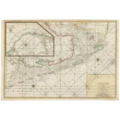
Large Sea Chart of the British Islands, 1918
About the Item
Antique map titled 'The British Islands'.
Large sea chart of the British Islands. It shows Ireland, Scotland, England, the Shetland Islands and part of France.
The antique sea chart titled 'The British Islands' is a significant cartographic work that provides a comprehensive depiction of the British Isles, including Ireland, Scotland, England, and the Shetland Islands, along with a portion of France. Published in 1918 by the Hydrographic Office, this corrected edition represents an important historical artifact from the early 20th century, reflecting the geographical knowledge and cartographic skills of the period.
Key aspects of this sea chart include:
Detailed Coastlines: The map showcases intricate details of the coastlines, inlets, bays, and capes, providing valuable information for navigation and understanding of the geographical layout of these regions.
Maritime Focus: Being a product of the Hydrographic Office, the chart is designed with a focus on maritime navigation, including details like sea routes, depth markings, and lighthouses or navigational aids relevant to sailors and shipping routes of the time.
Historical Context: The publication date of 1918 places this chart in a significant historical context, coming just after the end of World War I. This period was one of considerable change and development in geopolitical boundaries and maritime technology, which might be reflected in the corrections and updates made in this edition.
Cartographic Style: The map reflects the cartographic style of the early 20th century, with an emphasis on accuracy and clarity. It would have been an essential tool for both navigation and general education about the geography of the British Isles.
Inclusion of Part of France: The inclusion of a section of France in the chart is intriguing, as it suggests a broader geopolitical or navigational interest, possibly highlighting key channels and sea routes between the British Isles and the European mainland.
Artistic and Technical Merit: While primarily functional, these charts are often appreciated for their artistic quality, with careful attention to detail and a style that reflects the cartographic traditions of the era.
As an artifact, this sea chart not only serves as a navigational aid but also as a historical document, offering insights into the state of geographical knowledge and maritime practices of the early 20th century. Its publication by the Hydrographic Office, an authoritative source in maritime cartography, further underlines its significance as a reliable and detailed representation of the region's geography during that period.
- Dimensions:Height: 41.74 in (106 cm)Width: 27.56 in (70 cm)Depth: 0 in (0.02 mm)
- Materials and Techniques:
- Period:1910-1919
- Date of Manufacture:1918
- Condition:Condition: Very good, blank verso. Please study image carefully.
- Seller Location:Langweer, NL
- Reference Number:
About the Seller
5.0
Platinum Seller
These expertly vetted sellers are 1stDibs' most experienced sellers and are rated highest by our customers.
Established in 2009
1stDibs seller since 2017
1,919 sales on 1stDibs
Typical response time: <1 hour
- ShippingRetrieving quote...Ships From: Langweer, Netherlands
- Return PolicyA return for this item may be initiated within 14 days of delivery.
More From This SellerView All
- Large Chart of the island and sea of Java, IndonesiaLocated in Langweer, NLAntique map titled 'Carte Esférica de la Isla Y Mar de Java'. Large chart of the island and sea of Java, Indonesia. Beautiful nautical chart, published 1863 in Spain.Category
Antique Mid-19th Century Maps
MaterialsPaper
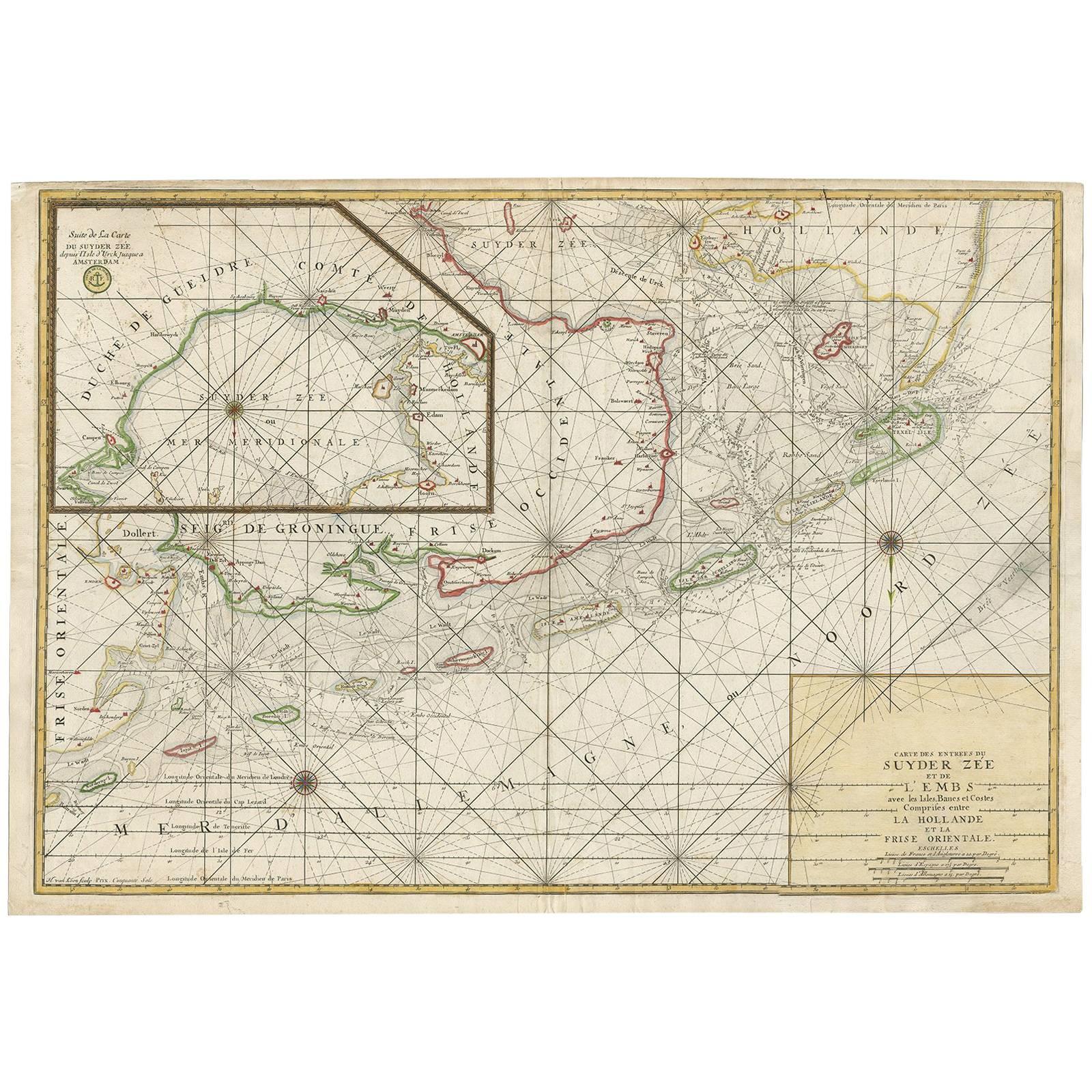
- Large Sea Chart of the Zuyder Zee & The Northsea with the Wadden Islands, 1773By H. van LoonLocated in Langweer, NLThe copper engraving by Herman van Loon, published by Pieter Mortier in 'Le Neptune François' in Amsterdam, is a remarkable piece within the realm of seventeenth-century cartography....Category
Antique Late 18th Century Maps
MaterialsPaper
- Antique Sea Chart of the Shetland Islands, Scotland, ca.1745Located in Langweer, NLAntique map of Scotland titled 'Nieuwe Paskaard van Hitland met de daar omleggende eylanden na de nieuwe aftekening gemaakt by den Lofwaarden en onvermoeyden Hit en Zeeman Ian Bruyst...Category
Antique 1740s Maps
MaterialsPaper
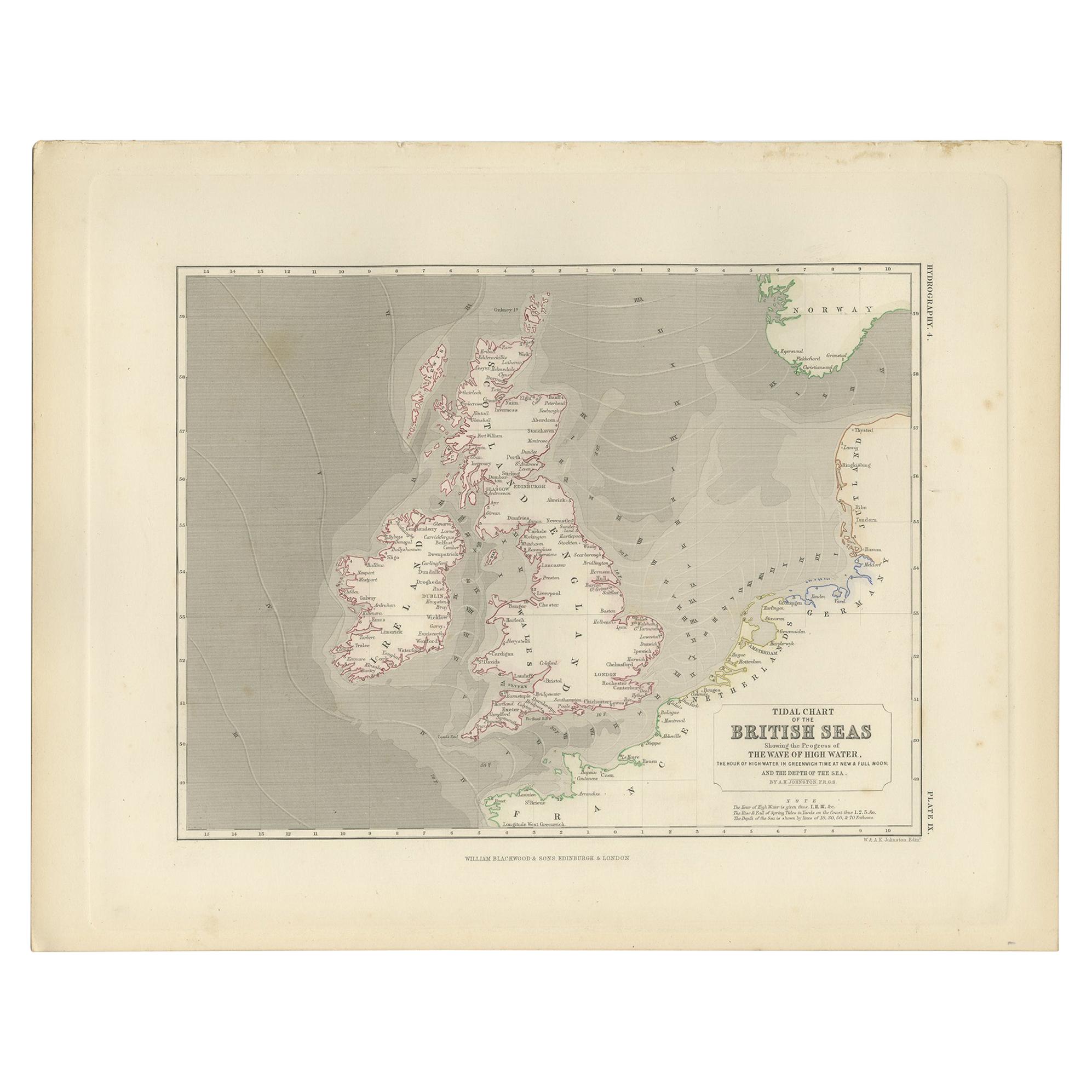
- Antique Tidal Chart of the British Seas by Johnston, '1850'Located in Langweer, NLAntique map titled 'Tidal Chart of the British Seas showing the progress of the wave of high water'. Original antique tidal chart of the British Seas. This map originates from 'The P...Category
Antique Mid-19th Century Maps
MaterialsPaper
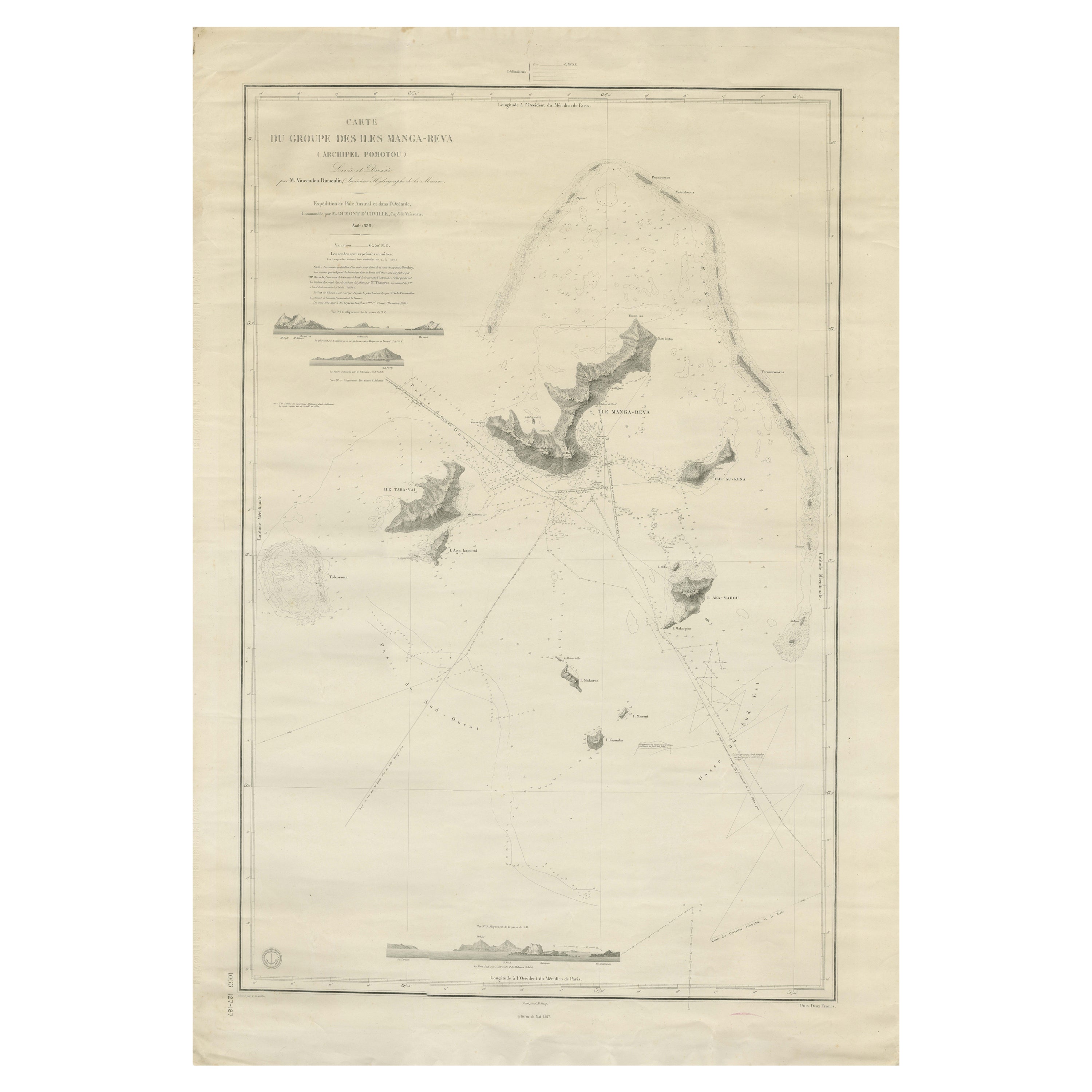
- Large Chart of the Gambier Islands, Tuamotu Archipelago, French PolynesiaLocated in Langweer, NLAntique map titled 'Carte du Groupe des Iles Manga-Reva (Archipel Pomotou)'. Large chart of the Tuamotu Archipelago, French Îles Tuamotu, also called Paumotu, island group of French ...Category
Antique Mid-19th Century Maps
MaterialsPaper
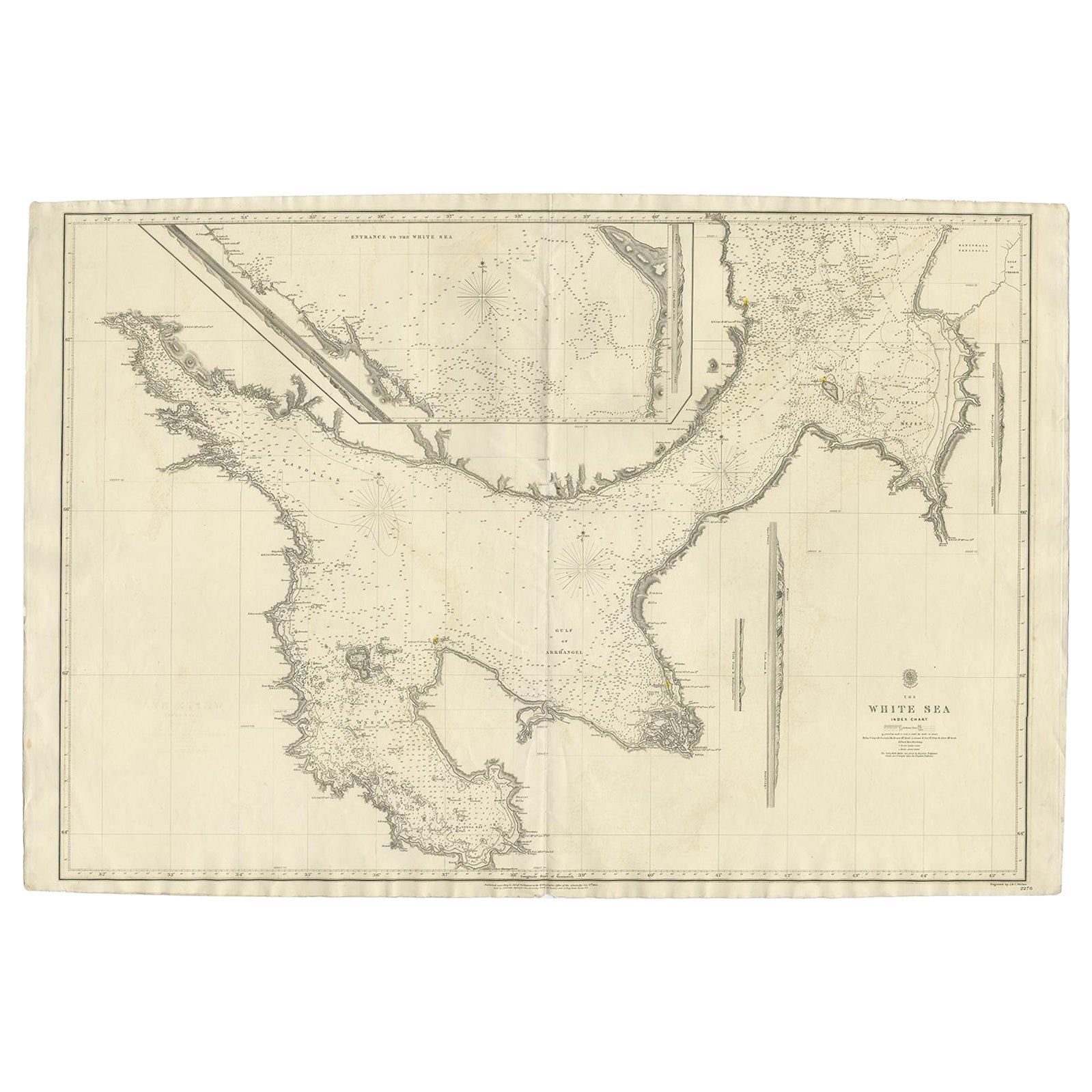
- Large Antique Chart of The White Sea, Russa 1854Located in Langweer, NLAntique map titled 'The White Sea Index Chart'. Large uncommon map of the White Sea with a smaller inset map of the entrance to the White Sea. The white sea is a southern inlet of th...Category
Antique 19th Century Maps
MaterialsPaper


You May Also Like
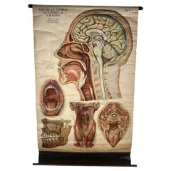
- 1918 American Frohse Anatomical Chart, A. J. Nystrom, Max Brodel IllustratorBy A.J. Nystrom & Co, Max BrödelLocated in Buffalo, NYAntique American Frohse Anatomical pull down chart, by A. J. Nystrom, ,revised and augmented by Max Brodel illustrator... Amazing color, patina, age appropriate wear. dated 1918.. Max (Paul Heinrich) Brödel 1870-1941 Brödel, an illustrator and the first director of the Art as Applied to Medicine program at Johns Hopkins...Category
Vintage 1910s American Steampunk Prints
MaterialsWood, Paper
- Hand-Colored 18th Century Homann Map of Denmark and Islands in the Baltic SeaBy Johann Baptist HomannLocated in Alamo, CAAn 18th century copper plate hand-colored map entitled "Insulae Danicae in Mari Balthico Sitae utpote Zeelandia, Fionia, Langelandia, Lalandia, Falstria, Fembria Mona" created by Joh...Category
Antique Early 18th Century German Maps
MaterialsPaper
- Antique Anatomical Wall Chart Depicting the Human SkeletonLocated in Berghuelen, DEA rare 19th century anatomical wall chart depicting the human skeleton. On the sides On the sides are detailed description in German language. The wall...Category
Early 20th Century German Victorian Prints
MaterialsPaper
- Large 17th Century Hand Colored Map of England and the British Isles by de WitBy Frederick de WitLocated in Alamo, CAA large hand colored 17th century map of England and the British Isles by Frederick de Wit entitled "Accuratissima Angliæ Regni et Walliæ Principatus", published in Amsterdam in 1680. It is a highly detailed map of England, Scotland, the Scottish Isles...Category
Antique Late 17th Century Dutch Maps
MaterialsPaper
- Anatomical Wall Chart Depicting the Human Lymphatic and Blood VesselsLocated in Berghuelen, DEA rare 19-carat anatomical wall chart depicting the human lymphatic and blood vessels. On the sides with detailed description in German language. Print...Category
Early 20th Century German Victorian Prints
MaterialsPaper
- Genito-Urinary Anatomical Chart Fritz FrohseBy Nystrom / Frohse Art, Fritz FrohseLocated in Philadelphia, PAGenito-Urinary Anatomical Chart by Fritz Frohse. Dated 1922. Paper mounted on canvas. Shows wear but still presents very well!Category
Vintage 1920s German American Classical Prints
MaterialsCanvas, Paper


Recently Viewed
View AllMore Ways To Browse
Antique Island Furniture
French Antique Island
Antique Chart
Antique Charts
Chart Antique
Ireland Map
Irish Map
Map Of Ireland
Antique Sea Chart
Antique Sea Charts
Sea Chart
Antique Ireland Maps
Antique Ireland Map
Antique Irish Map
Antique Maps Ireland
Antique Map Ireland
Antique Map Of Ireland
Antique Maps Of Ireland