Gerard Mercator Art
Flemish, German, 1512-1594
Gerard Mercator (1512-1594) was one of the most famous cartographers of the 16th century and, in fact, of all time. Mercator was known for his strict adherence to scientific methods of the day. He was responsible for advancing the technology of map making. For example his method of representing land masses in a cylindrical projection with north up and south down, first described in 1569, became the standard map projection for navigation. It is still referred to as The Mercator projection. to
2
6
3
9
8
4
3
3
1
Rugen Island, Germany: An Early 17th Century Map by Mercator and Hondius
By Gerard Mercator
Located in Alamo, CA
This is an early 17th century map entitled "Nova Famigerabilis Insulae Ac Ducatus Rugiae Desciptio" (Map of Rugen Island, Germany) by Gerard Mercator and Henricus and Joducus Hondiu...
Category
Early 17th Century Old Masters Gerard Mercator Art
Materials
Engraving
Southeastern England: A 17th Century Hand-Colored Map by Mercator and Hondius
By Gerard Mercator
Located in Alamo, CA
A 17th century copperplate hand-colored map entitled "The Sixt Table of England" by Gerard Mercator and Jodocus Hondius, published in Amsterdam in 1635 in 'Cosmographicall Descriptio...
Category
1630s Gerard Mercator Art
Materials
Engraving
Original Antique Map of Turkey, Asia Minor and Cyprus
By Gerard Mercator
Located in Langweer, NL
Antique map titled 'Natoliae sive Asia Minor'. Original old map of Turkey, Asia Minor and Cyprus. Includes a decorative cartouches, sailing ship, sea mon...
Category
Early 17th Century Antique Gerard Mercator Art
Materials
Paper
$782 Sale Price
20% Off
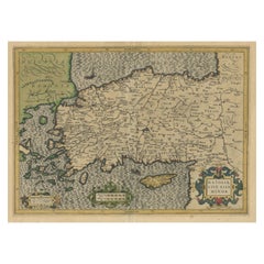
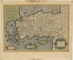
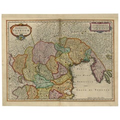
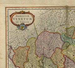
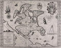
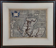
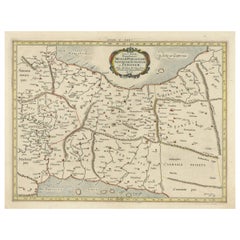
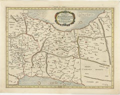
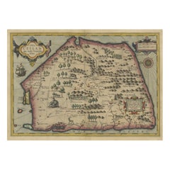
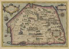
West Africa: A 17th Century Hand-Colored Map by Mercator/Hondius
By Gerard Mercator
Located in Alamo, CA
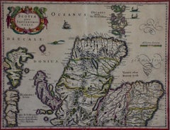
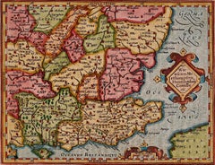
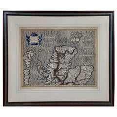
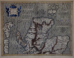
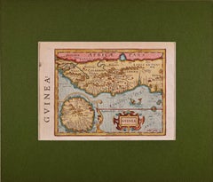
A 17th century hand-colored map entitled "Guineae Nova Descriptio" by Gerard Mercator and Jodocus Hondius, published in their 'Atlas Minor' in Amsterdam in 1635. It is focused on the...
Category
1630s Gerard Mercator Art
Materials
Engraving
Antique Map of the Southern Lorraine Region by Mercator, c.1625
By Gerard Mercator
Located in Langweer, NL
Antique map titled 'Lotharingiae Ducatus'. Old map of the southern portion of the Lorraine region, France. Lorraine is a cultural and historical region in north-eastern France, now l...
Category
17th Century Antique Gerard Mercator Art
Materials
Paper
$270 Sale Price
20% Off
Antique Map of the Area Around Venice in Italy by H. Hondius, circa 1606
By Gerard Mercator, Jodocus Hondius
Located in Langweer, NL
Attractive and early map of the area around Venice, Italy. With South-Tirol in the North, areas of Krain (Slovenia), Croatia, Ferrara, Modena and Piacenza. In the east with areas aro...
Category
Early 17th Century Dutch Antique Gerard Mercator Art
Materials
Paper
Southeastern Ireland: A 17th Century Hand Colored Map by Mercator and Hondius
By Gerard Mercator
Located in Alamo, CA
A 17th century copperplate hand-colored map entitled "The Second Table of Ireland, Udrone" by Gerard Mercator and Jodocus Hondius, published in Amsterdam in 1635 in 'Cosmographicall ...
Category
1630s Gerard Mercator Art
Materials
Engraving
Northern Scotland: 17th Century Hand-colored Map by Mercator
By Gerard Mercator
Located in Alamo, CA
This is a framed hand-colored 17th century map of Northern Scotland by Gerard Mercator entitled "Scotiae pars Septentrionalis", published in Amsterdam in 1636. It is a highly detailed map of the northern part of Scotland, with the northwest Highlands and the cities Inverness and Aberdeen, as well as the Orkney Islands and the Hebrides. There is a decorative title cartouche in the upper left corner.
The map is presented in an antiqued brown wood...
Category
Mid-17th Century Other Art Style Gerard Mercator Art
Materials
Engraving
Northern Scotland: 16th Century Hand-colored Map by Mercator
By Gerard Mercator
Located in Alamo, CA
This is a framed hand-colored 16th century map of Northern Scotland by Gerard Mercator entitled "Scotiae pars Septentrionalis", published in Amsterdam in 1636. It is a highly detailed map of the northern part of Scotland, with the northwest Highlands and the cities Inverness and Aberdeen, as well as the Orkney Islands and the Hebrides. There is a decorative title cartouche in the upper left corner.
The map is presented in an antiqued brown wood...
Category
16th Century Other Art Style Gerard Mercator Art
Materials
Engraving
Related Items
Antique Map of Principality of Monaco
By Antonio Vallardi Editore
Located in Alessandria, Piemonte
ST/619 - "Old Geographical Atlas of Italy - Topographic map of ex-Principality of Monaco" -
ediz Vallardi - Milano -
A somewhat special edition ---
Category
Late 19th Century Italian Other Antique Gerard Mercator Art
Materials
Paper
Plan of the Park, Garden and Plantations of Goodwood, 18th century engraving
By Colen Campbell
Located in Melbourne, Victoria
Plan of the Park, Garden and Plantations of Goodwood in Sussex the Seat of his Grace the Duke of Richmond and Lenox &c
Copper-line engraving with later hand-colouring by Hendrik Hul...
Category
18th Century English School Gerard Mercator Art
Materials
Engraving
$450
H 21.26 in W 27.56 in
Carte Particuliere Des Coste De Bretagne qui Comprend Morlaix
By Pierre Mortier
Located in Paonia, CO
Carte Particuliere Des Costes De Bretagne qui Comprend Morlaix, Saint Paul de Leon, les Sept Isles, et L’Isle. Faite par ordre Exprez Du Roy de France is from the collection of ch...
Category
1690s Gerard Mercator Art
Materials
Engraving
$1,350
H 25 in W 37.5 in
Lafitte's Blacksmith House (a bar named for a pirate on Bourbon St, New Orleans)
By Frederick Mershimer
Located in New Orleans, LA
Lafitte's Blacksmith Shop is a New Orleans landmark at 941 Bourbon St. Like most New Orleans legends, history of Lafitte's Blacksmith Shop is a gumbo of tru...
Category
Early 2000s Contemporary Gerard Mercator Art
Materials
Mezzotint, Aquatint
Here They Come !
By Frank W. Benson
Located in New York, NY
This impression of "Here They Come !" is from the fourth state of eight. There are six known impressions of the fourth state. Edition 150 (final state). It is signed in pencil in the lower left and inscribed "D-1". The image size 13 7/8 x 11 3/4" (34.6 x 28.8 cm) and sheet size 16 3/4 x 14 5/8" (42.8 x 37.1 cm).
FRANK W. BENSON (1862-1951)
Frank Weston Benson, well known for his American impressionist paintings, also produced an incredible body of prints - etchings, drypoints, and a few lithographs. Born and raised on the North Shore of Massachusetts, Benson, a natural outdoorsman, grew up sailing, fishing, and hunting. From a young age, he was fascinated with drawing and birding – this keen interest continued throughout his life.
His first art instruction was with Otto Grundman at the Museum of Fine Arts in Boston, and then in 1883 in Paris at the Academie Julian where he studied the rigorous ‘ecole des beaux arts’ approach to drawing and painting for two years.
During the early 1880’s Seymour Haden visited Boston giving a series of lectures on etching. This introduction to the European etching...
Category
1920s American Impressionist Gerard Mercator Art
Materials
Drypoint
Hand-Colored 18th Century Homann Map of the Danube, Italy, Greece, Croatia
By Johann Baptist Homann
Located in Alamo, CA
"Fluviorum in Europa principis Danubii" is a hand colored map of the region about the Danube river created by Johann Baptist Homann (1663-1724) in his 'Atlas Novus Terrarum', publish...
Category
Early 18th Century German Antique Gerard Mercator Art
Materials
Paper
$875
H 20 in W 23.88 in D 0.07 in
Original Antique Map of Spain and Portugal, circa 1790
Located in St Annes, Lancashire
Super map of Spain and Portugal
Copper plate engraving by A. Bell
Published, circa 1790.
Unframed.
Category
1790s English Other Antique Gerard Mercator Art
Materials
Paper
Foggy Night (the way home or a Stephen King setting)
By Carol Wax
Located in New Orleans, LA
This impression is #22
Carol Wax originally trained to be a classical musician at the Manhattan School of Music but fell in love with printmaking. Soon after she began engraving mezzotints she was asked by the renowned print dealer Sylvan Cole to exhibit at Associated American Artists Gallery, launching her career as a professional artist/printmaker. With the publication of her book, The Mezzotint: History and Technique, published by Abrams, 1990 and 1996, Carol added author and teacher to her credits. In the ensuing years she has expanded her repertoire of mediums beyond printmaking into other works on paper and painting.
In compositions reflecting an appreciation for antiquated machinery and vintage textiles, Wax creates imagery that, in her own words, “… speaks to an inner life perceived in inanimate objects.” She uses stylization and imagination to reinvent subjects, transforming an ordinary typewriter into a monumental icon...
Category
2010s American Modern Gerard Mercator Art
Materials
Engraving, Mezzotint
Island of Philae, Egypt. Early 19th century engraving, 1820
Located in Melbourne, Victoria
'Ile de Philae : Vue de l'edifice de l'est et de plusieurs monuments'
(Island of Philae : View of the east building and other monuments)
Elephant folio engraving, by Baltard after...
Category
Early 19th Century Other Art Style Gerard Mercator Art
Materials
Engraving
Original Antique Map or City Plan of Venice, Italy. Circa 1835
Located in St Annes, Lancashire
Nice map of Venice
Drawn and engraved by J.Dower
Published by Orr & Smith. C.1835
Unframed.
Free shipping
Category
1830s English Antique Gerard Mercator Art
Materials
Paper
Original Antique Map of Ancient Greece, Achaia, Corinth, 1786
Located in St Annes, Lancashire
Great map of Ancient Greece. Showing the region of Thessaly, including Mount Olympus
Drawn by J.D. Barbie Du Bocage
Copper plate engraving by P.F Tardieu
Original hand color...
Category
1780s French Other Antique Gerard Mercator Art
Materials
Paper
Original Antique Map of The World by Thomas Clerk, 1817
Located in St Annes, Lancashire
Great map of The Eastern and Western Hemispheres
On 2 sheets
Copper-plate engraving
Drawn and engraved by Thomas Clerk, Edinburgh.
Published by Mackenzie And Dent, 1817
...
Category
1810s English Antique Gerard Mercator Art
Materials
Paper
Previously Available Items
Antique Ptolemaic Map of Modern-Day Iran, Iraq and Part of Armenia
By Gerard Mercator
Located in Langweer, NL
Antique map titled 'Tab. V. Asiae Repraesentans Mediam, Hyrcaniam, Assyriam, Susuanam ac Persidem'. Ptolemaic map of much of modern-day Iran, Iraq and part of Armenia. The map stretches from the Persian Gulf...
Category
Late 17th Century Antique Gerard Mercator Art
Materials
Paper
Stunning Antique Map of the Island Ceylon or Sri Lanka
By Gerard Mercator
Located in Langweer, NL
Antique map titled 'Ins. Ceilan quae incolis Tenarisin dicitur'. This exquisite, early map of Sri Lanka is shown with an unusual five-sided shape. North is oriented to the left by an...
Category
Early 17th Century Antique Gerard Mercator Art
Materials
Paper
Bordeaux Region of France: A 17th Century Hand-Colored Map by Mercator/Hondius
By Gerard Mercator
Located in Alamo, CA
This is a 17th century hand-colored map entitled "Bourdelois Pais de Medoc et la Prevoste de Born" by Gerard Mercator and Henricus Hondius, published in their 'Atlas Minor' in Amster...
Category
1630s Gerard Mercator Art
Materials
Engraving
Valencia and Murcia, Spain: A 17th Century Hand-Colored Map by Mercator/Hondius
By Gerard Mercator
Located in Alamo, CA
A 17th century hand-colored map entitled "Regni Valentiae Typus, Valentia and Murcia" by Gerard Mercator and Joducus Hondius, published in Amsterdam in 1635 in 'Cosmographicall Descr...
Category
1630s Gerard Mercator Art
Materials
Engraving
Antique Map of the Peloponnesos peninsula by Mercator, circa 1620
By Gerard Mercator
Located in Langweer, NL
Antique map titled 'Morea olim Peloponnesus'. A beautiful and decorative map of the Peloponnesos peninsula in southern Greece. This region was called Morea well into the 19th century...
Category
Early 17th Century Antique Gerard Mercator Art
Materials
Paper
Antique Map of Scotland by Mercator, circa 1605
By Gerard Mercator
Located in Langweer, NL
Antique map titled 'Scotia Regnum'. One of the earliest obtainable maps of Scotland. Published by G. Mercator, one of the most famous cartographers of all time.
Category
Early 17th Century Antique Gerard Mercator Art
Materials
Paper
Gerard Mercator art for sale on 1stDibs.
Find a wide variety of authentic Gerard Mercator art available for sale on 1stDibs. You can also browse by medium to find art by Gerard Mercator in engraving and more. Much of the original work by this artist or collective was created during the 18th century and earlier and is mostly associated with the Old Masters style. Not every interior allows for large Gerard Mercator art, so small editions measuring 12 inches across are available. Customers who are interested in this artist might also find the work of Giovan Battista Falda, Joan (Johannes) Blaeu, and Israel Silvestre. Gerard Mercator art prices can differ depending upon medium, time period and other attributes. On 1stDibs, the price for these items starts at $380 and tops out at $940, while the average work can sell for $625.