
Homann Heirs Wall Decorations

5
to
1
5
5
5
5
5
Height
to
Width
to
5
1
1
12
428
291
282
265
Creator: Homann Heirs
Antique Map of the Waldeck Region of Germany by Homann Heirs, circa 1733
By Homann Heirs
Located in Langweer, NL
Antique map titled 'Waldecciae ac finitimorum Dominiorum (.)'. Map of the Waldeck region of Germany. With decorative cartouche depicting people mining, fishing and deer hunting with ...
Category

18th Century Antique Homann Heirs Wall Decorations

Materials

Paper

Antique Map of the Seventeen Provinces by Homann Heirs, 1748
By Homann Heirs
Located in Langweer, NL
Antique map titled 'Belgii Universi seu Inferioris Germaniae quam XVII Provinciae (..)'. Map of the Seventeen Provinces after Tobias Meier, published by Homann's Heirs in 1748. The S...
Category

18th Century Antique Homann Heirs Wall Decorations

Materials

Paper

Antique Map of the Seventeen Provinces of Netherlands, Belgium, Luxembourg, 1748
By Homann Heirs
Located in Langweer, NL
Antique map titled 'Belgii Universi seu Inferioris Germaniae quam XVII Provinciae (..)'. Map of the Seventeen Provinces after Tobias Meier, published by Homann's Heirs in 1748. The...
Category

18th Century Antique Homann Heirs Wall Decorations

Materials

Paper

Antique Map of Denmark with the Danish Royal Crest, c.1730
By Homann Heirs
Located in Langweer, NL
Antique map titled 'Regni Daniae in quo sunt Ducatus Holsatia and Slesuicum Insulae Danicae Jutia, Scania Blekingia (..).' Map of Denmark and islands, part of Sweden and Germany, dra...
Category

18th Century Antique Homann Heirs Wall Decorations

Materials

Paper

Antique Map Normandy 'France' by Homann Heirs, Published in c.1740
By Homann Heirs
Located in Langweer, NL
Antique map France titled 'Normannia Galliae celebris Provincia in terras suas Ballisiatus (..)'. Decorative regional map of Normandy, France, circa ...
Category

Mid-18th Century German Antique Homann Heirs Wall Decorations

Materials

Paper

Related Items
Original Antique Map of India. C.1780
Located in St Annes, Lancashire
Great map of India Copper-plate engraving Published C.1780 Three small worm holes to right side of map and one bottom left corner Unframed.
Category

Early 1800s English Georgian Antique Homann Heirs Wall Decorations

Materials

Paper

Original Antique Map of India. C.1780
No Reserve
H 8.75 in W 12.5 in D 0.07 in
Original Antique Map of Spain and Portugal, circa 1790
Located in St Annes, Lancashire
Super map of Spain and Portugal Copper plate engraving by A. Bell Published, circa 1790. Unframed.  
Category

1790s English Other Antique Homann Heirs Wall Decorations

Materials

Paper

Original Antique Map of Spain and Portugal, circa 1790
No Reserve
H 8.25 in W 11 in D 0.07 in
Original Antique Map of Ancient Greece- Boeotia, Thebes, 1787
Located in St Annes, Lancashire
Great map of Ancient Greece. Showing the region of Boeotia, including Thebes Drawn by J.D. Barbie Du Bocage Copper plate engraving by P.F T...
Category

1780s French Other Antique Homann Heirs Wall Decorations

Materials

Paper

Original Antique Map of Ancient Greece, Achaia, Corinth, 1786
Located in St Annes, Lancashire
Great map of Ancient Greece. Showing the region of Thessaly, including Mount Olympus Drawn by J.D. Barbie Du Bocage Copper plate engraving by P.F Tardieu Original hand color...
Category

1780s French Other Antique Homann Heirs Wall Decorations

Materials

Paper

Original Antique Map of Italy. C.1780
Located in St Annes, Lancashire
Great map of Italy Copper-plate engraving Published C.1780 Unframed.
Category

Early 1800s English Georgian Antique Homann Heirs Wall Decorations

Materials

Paper

Original Antique Map of Italy. C.1780
No Reserve
H 8.25 in W 12 in D 0.07 in
Original Antique Map of The World by Thomas Clerk, 1817
Located in St Annes, Lancashire
Great map of The Eastern and Western Hemispheres On 2 sheets Copper-plate engraving Drawn and engraved by Thomas Clerk, Edinburgh. Published by Mackenzie And Dent, 1817 ...
Category

1810s English Antique Homann Heirs Wall Decorations

Materials

Paper

Original Antique Map of The World by Thomas Clerk, 1817
No Reserve
H 10.25 in W 8.25 in D 0.07 in
Original Antique Map of Asia. C.1780
Located in St Annes, Lancashire
Great map of Asia Copper-plate engraving Published C.1780 Two small worm holes to right side of map Unframed.
Category

Early 1800s English Georgian Antique Homann Heirs Wall Decorations

Materials

Paper

Original Antique Map of Asia. C.1780
No Reserve
H 8.75 in W 12.25 in D 0.07 in
Original Antique Map of Switzerland, Engraved By Barlow, Dated 1807
Located in St Annes, Lancashire
Great map of Switzerland Copper-plate engraving by Barlow Published by Brightly & Kinnersly, Bungay, Suffolk. Dated 1807 Unframed.
Category

Early 1800s English Antique Homann Heirs Wall Decorations

Materials

Paper

Original Antique Map of The Netherlands, Engraved by Barlow, Dated 1807
Located in St Annes, Lancashire
Great map of Netherlands Copper-plate engraving by Barlow Published by Brightly & Kinnersly, Bungay, Suffolk. Dated 1807 Unframed.
Category

Early 1800s English Antique Homann Heirs Wall Decorations

Materials

Paper

Antique 18th Century Map of the Province of Pensilvania 'Pennsylvania State'
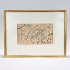
Located in Philadelphia, PA
A fine antique of the colony of Pennsylvania. 
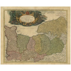
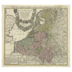
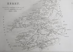
Noted at the top of the sheet as a 'Map of the province of Pensilvania'. This undated and anonymous map is thought to be from the Gentleman's Magazine, London, circa 1775, although the general appearance could date it to the 1760's. The southern boundary reflects the Mason-Dixon survey (1768), the western boundary is placed just west of Pittsburgh, and the northern boundary is not marked. The map has a number of reference points that likely refer to companion text and appear to be connected to boundaries. The western and southern boundaries are marked Q, R, S, for example. A diagonal line runs from the Susquehanna R to the Lake Erie P. A broken line marked by many letters A, B, N, O, etc., appears in the east. There are no latitude or longitude markings, blank verso. Framed in a shaped contemporary gilt wooden frame and matted under a cream colored matte. Bearing an old Graham Arader Gallery...
Category

18th Century British American Colonial Antique Homann Heirs Wall Decorations

Materials

Paper

Original Antique Map of Spain and Portugal, Engraved By Barlow, 1806
Located in St Annes, Lancashire
Great map of Spain And Portugal Copper-plate engraving by Barlow Published by Brightly & Kinnersly, Bungay, Suffolk. 1806 Unframed.
Category

Early 1800s English Antique Homann Heirs Wall Decorations

Materials

Paper

Original Antique Map of Sweden, Engraved by Barlow, 1806
Located in St Annes, Lancashire
Great map of Sweden Copper-plate engraving by Barlow Published by Brightly & Kinnersly, Bungay, Suffolk. 1806 Unframed.  
Category

Early 1800s English Antique Homann Heirs Wall Decorations

Materials

Paper

Homann Heirs wall decorations for sale on 1stDibs.

Homann Heirs wall decorations are available for sale on 1stDibs. These distinctive items are frequently made of paper and are designed with extraordinary care. There are many options to choose from in our collection of Homann Heirs wall decorations, although beige editions of this piece are particularly popular. If you’re looking for additional options, many customers also consider wall decorations by Johann Wilhelm Weinmann, Basilius Besler, and Albrecht Dürer. Prices for Homann Heirs wall decorations can differ depending upon size, time period and other attributes — on 1stDibs, these items begin at $366 and can go as high as $865, while a piece like these, on average, fetch $485.

Recently Viewed

View All