Items Similar to Antique Map of the Waldeck Region of Germany by Homann Heirs, circa 1733


Want more images or videos?
Request additional images or videos from the seller
1 of 6
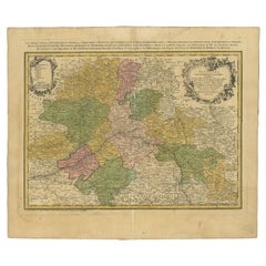
Antique Map of the Waldeck Region of Germany by Homann Heirs, circa 1733
About the Item
Antique map titled 'Waldecciae ac finitimorum Dominiorum (.)'. Map of the Waldeck region of Germany. With decorative cartouche depicting people mining, fishing and deer hunting with a bow.
Artists and Engravers: Following the long period of Dutch domination, the Homann family became the most important map publishers in Germany in the eighteenth century, the business being founded by J.B. Homann in Nuremberg about the year 1702. Soon after publishing his first atlas in 1707 he became a member of the Berlin academy of Sciences and in 1715 he was appointed Geographer to the Emperor. After the founder's death in 1724, the firm was continued under the direction of his son until 1730 and was then bequeathed to his heirs on the condition that it trades under the name of Homann Heirs. The firm remained in being until the next century and had a wide influence on map publishing in Germany. Apart from the atlases the firm published a very large number of individual maps. The Homanns produced a Neuer Atlas in 1714, a Grosser Atlas in 1737, and an Atlas Maior with about 300 maps in 1780. They also issued a special Atlas of Germany with full sized plans of principal cities, school atlases and an Atlas of Silesia in 1750 with 20 maps.
Condition: Fair/good, original/contemporary hand coloring. Repair on folding line and left margin. Blank verso, please study image carefully.
Date: 1733
Overall Size: 50.5 x 58 cm.
Image Size: 47.5 x 55 cm.
We sell original antique maps to collectors, historians, educators and interior decorators all over the world. Our collection includes a wide range of authentic antique maps from the 16th to the 20th centuries. Buying and collecting antique maps is a tradition that goes back hundreds of years. Antique maps have proved a richly rewarding investment over the past decade, thanks to a growing appreciation of their unique historical appeal. Today the decorative qualities of antique maps are widely recognized by interior designers who appreciate their beauty and design flexibility. Depending on the individual map, presentation, and context, a rare or antique map can be modern, traditional, abstract, figurative, serious or whimsical. We offer a wide range of authentic antique maps for any budget.
- Creator:Homann Heirs (Artist)
- Dimensions:Height: 22.84 in (58 cm)Width: 19.89 in (50.5 cm)Depth: 0 in (0.01 mm)
- Materials and Techniques:
- Period:
- Date of Manufacture:1733
- Condition:Repaired: Repair on folding line and left margin. Condition: Fair/good, original/contemporary hand coloring. Blank verso, please study image carefully.
- Seller Location:Langweer, NL
- Reference Number:
About the Seller
5.0
Platinum Seller
These expertly vetted sellers are 1stDibs' most experienced sellers and are rated highest by our customers.
Established in 2009
1stDibs seller since 2017
1,919 sales on 1stDibs
Typical response time: <1 hour
- ShippingRetrieving quote...Ships From: Langweer, Netherlands
- Return PolicyA return for this item may be initiated within 14 days of delivery.
More From This SellerView All
- Antique Map of the Seventeen Provinces by Homann Heirs, 1748By Homann HeirsLocated in Langweer, NLAntique map titled 'Belgii Universi seu Inferioris Germaniae quam XVII Provinciae (..)'. Map of the Seventeen Provinces after Tobias Meier, published by Homann's Heirs in 1748. The S...Category
Antique 18th Century Maps
MaterialsPaper
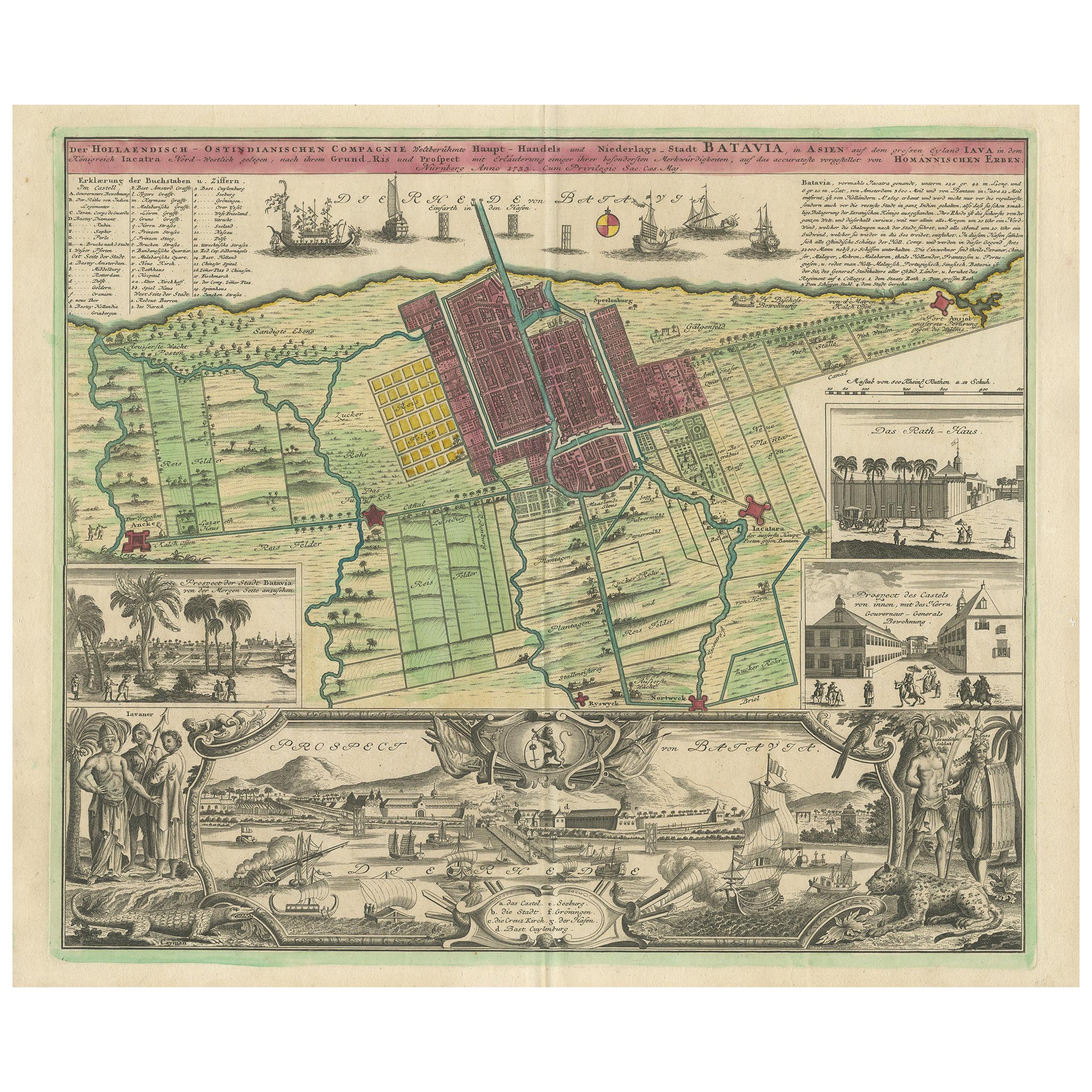
- Antique Map and Views of Batavia by Homann Heirs, '1733'Located in Langweer, NLAntique map titled 'Der Hollaendisch-Ostindianischen Compagnie weltberuhmte Haupt-Handels und Niederlags-Stadt Batavia, in Asien auf dem grossen Eyland Iava in dem konigreich Iacatra...Category
Antique Mid-18th Century Maps
MaterialsPaper
- Antique Map of the Region of Orleans by Homann Heirs, c.1760By Homann HeirsLocated in Langweer, NLAntique map titled 'Novissima Totius Aureliani Generalitatis (..) - Nouvelle Carte du Gouvernement General et Militaire d'Orleans (..).' Detailed map by Rizzi Zononi covering the vic...Category
Antique 18th Century Maps
MaterialsPaper
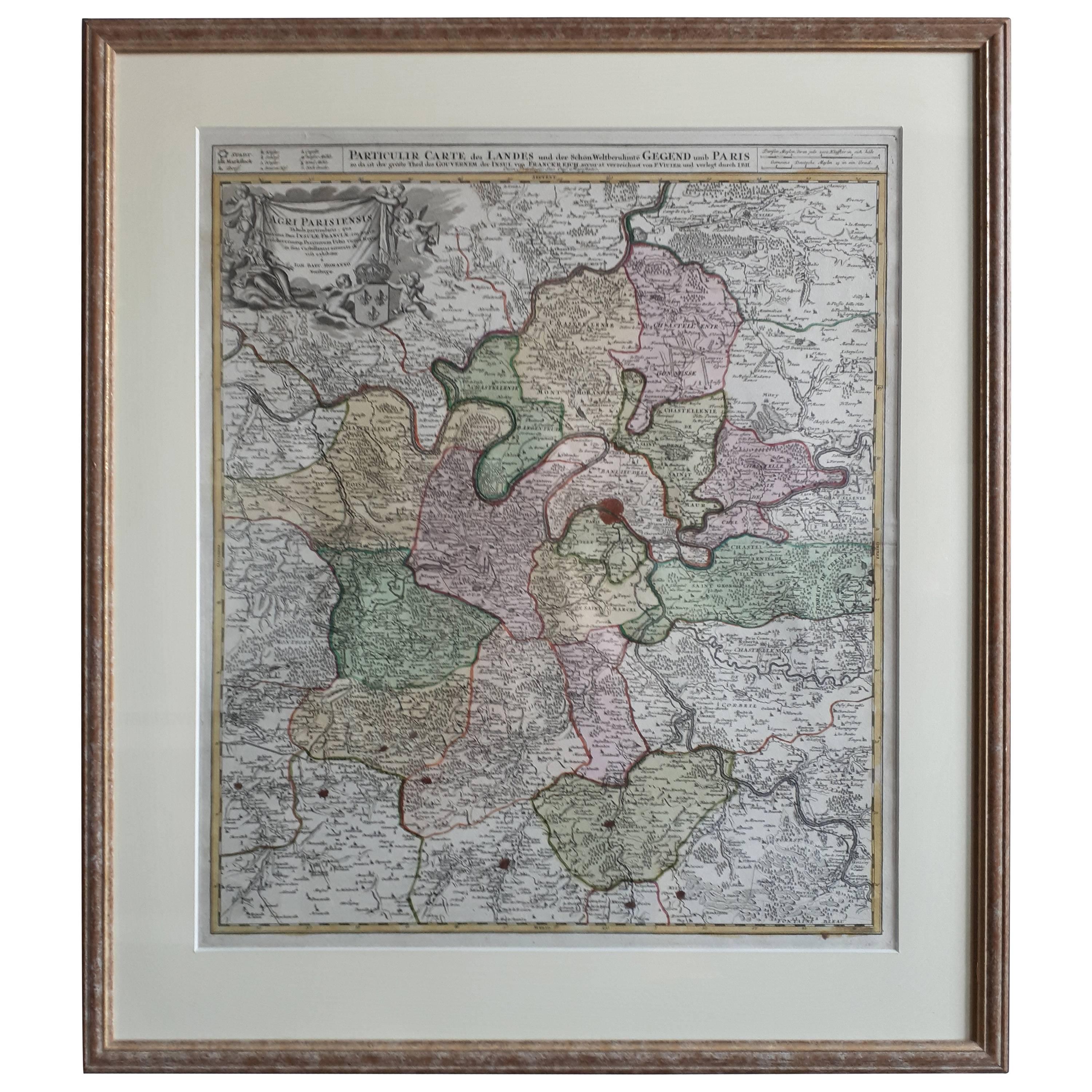
- Antique Map of the Region of Paris by Homann Heirs, c.1720By Homann HeirsLocated in Langweer, NLAntique map titled 'Agri Parisiensis Tabula particularis, qua maxima Pars Insulae Franciae (..).' Incredibly detailed map showing everything from tiny villages to forests, farmland, ...Category
Antique 18th Century Maps
MaterialsPaper
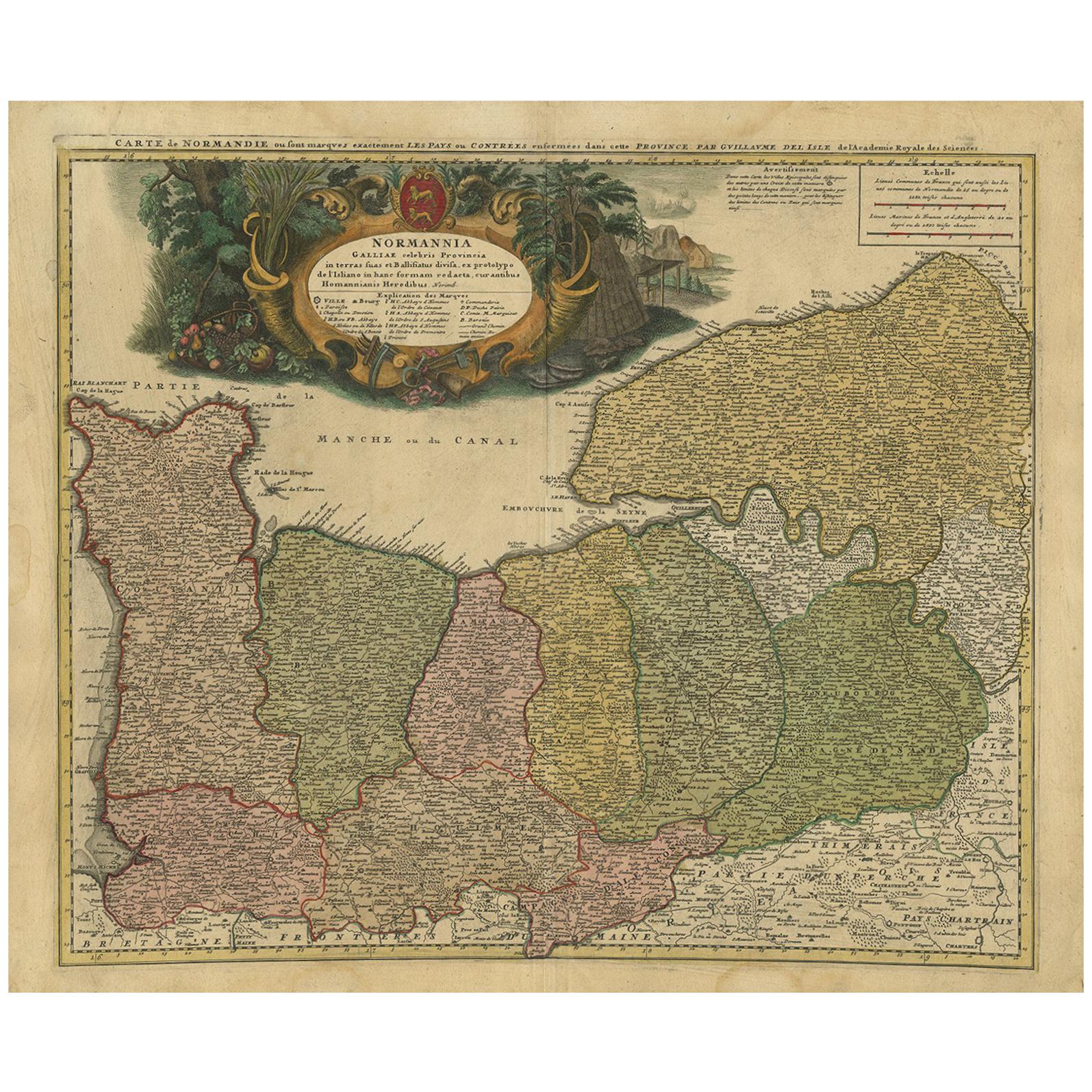
- Antique Map Normandy 'France' by Homann Heirs, Published in c.1740By Homann HeirsLocated in Langweer, NLAntique map France titled 'Normannia Galliae celebris Provincia in terras suas Ballisiatus (..)'. Decorative regional map of Normandy, France, circa ...Category
Antique Mid-18th Century German Maps
MaterialsPaper
- Antique Map of Africa by Homann Heirs, '1804'Located in Langweer, NLAntique map titled 'Charte von Africa'. Large, original antique map of Africa by Franz Ludwig Güssefeld. Published by Homann Heirs, 1804.Category
Antique Early 19th Century Maps
MaterialsPaper


You May Also Like
- 18th Century Hand-Colored Homann Map of Germany, Including Frankfurt and BerlinBy Johann Baptist HomannLocated in Alamo, CAAn 18th century hand-colored map entitled "Tabula Marchionatus Brandenburgici et Ducatus Pomeraniae quae sunt Pars Septentrionalis Circuli Saxoniae Superioris" by Johann Baptist Homa...Category
Antique Early 18th Century German Maps
MaterialsPaper
- 17th Century Hand-Colored Map of a Region in West Germany by JanssoniusBy Johannes JanssoniusLocated in Alamo, CAThis attractive highly detailed 17th century original hand-colored map is entitled "Archiepiscopatus Maghdeburgensis et Anhaltinus Ducatus cum terris adjacentibus". It was published ...Category
Antique Mid-17th Century Dutch Maps
MaterialsPaper
- Hand-Colored 18th Century Homann Map of the Danube, Italy, Greece, CroatiaBy Johann Baptist HomannLocated in Alamo, CA"Fluviorum in Europa principis Danubii" is a hand colored map of the region about the Danube river created by Johann Baptist Homann (1663-1724) in his 'Atlas Novus Terrarum', publish...Category
Antique Early 18th Century German Maps
MaterialsPaper
- Sweden & Adjacent Portions of Scandinavia: A Hand-Colored 18th C. Map by HomannBy Johann Baptist HomannLocated in Alamo, CAThis hand-colored map of Sweden and adjacent portions of Scandinavia entitled "Regni Sueciae in Omnes suas Subjacentes Provincias accurate divisi Tabula Generalis" was created by Joh...Category
Antique 1720s German Maps
MaterialsPaper
- The Kingdom of Naples and Southern Italy: A Hand-Colored 18th Century Homann MapBy Johann Baptist HomannLocated in Alamo, CA"Novissima & exactissimus Totius Regni Neapolis Tabula Presentis Belli Satui Accommo Data" is a hand colored map of southern Italy and the ancient Kingdom of Naples created by Johann...Category
Antique Early 18th Century German Maps
MaterialsPaper
- Hand Colored 18th Century Homann Map of Austria Including Vienna and the DanubeBy Johann Baptist HomannLocated in Alamo, CA"Archiducatus Austriae inferioris" is a hand colored map of Austria created by Johann Baptist Homann (1663-1724) and published in Nuremberg, Germany in 1728 shortly after his death. ...Category
Antique Early 18th Century German Maps
MaterialsPaper


Recently Viewed
View AllMore Ways To Browse
Auge En Pierre
Aigue Marine
Antiques Oran Map
Moldova Antique Map
Staffordshire Antique Map
Staffordshire Map
Antique Furniture Manitoba
Antique Maps Denver
Cape Cod Map
H Chatelain 1719
Map Of Antigua
Map Of Cape Cod
Nova Hollandia
Yugoslavia Map
Antique Map Cleveland
Antique Map Livonia
Atlas Indu
Bubble Glass Book Ends