By Dirk Vander Kooij
Located in Culver City, CA
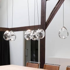
In the opulent world of the uber-rich, where mansions are counted in the tens of millions, and pop superstars reign supreme, one can expect nothing less than extravagance in every detail. Amidst the glittering gems of a $70 million mansion owned by a legendary pop sensation, we had the honor of acquiring a custom chandelier that defies convention and embodies the spirit of luxury and creativity. Allow me to introduce you to a dazzling masterpiece—a one-of-a-kind creation by none other than the visionary Dirk Van Der Kooij.
Picture yourself stepping into a lavish, sun-drenched living room, adorned with the finest furniture money can buy. In this resplendent space, the centerpiece of the room is the extraordinary custom chandelier—a breathtaking work of art that beckons the gaze of those who dare enter.
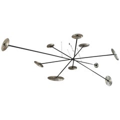
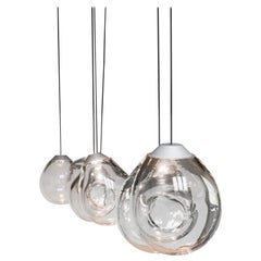
This chandelier is unlike anything you've ever seen. It's as if an intricate web of tinker toy sticks and wheels has come to life, monumentally suspended from the ceiling in a mesmerizing display. Crisscrossing black rods weave an intricate pattern, resembling the playful sticks of childhood imagination, yet with an adult sophistication that captures the essence of modern luxury.
The magic of this chandelier lies in its radiant, wheel-shaped 3D-printed recycled plastic rings. These translucent rings, adorned with a riot of bright lights, cast a celestial glow, reminiscent of twinkling stars on a clear night. Imagine standing beneath this celestial marvel, feeling as if you're gazing at the very cosmos itself.
But what truly sets this chandelier apart are the circular black balls nestled at its core, reminiscent of the center of a Tootsie Roll Pop. These unique orbs, resembling beautifully lit lollipops, add a whimsical touch to the chandelier's design, infusing an air of playfulness and joy into the opulent setting.
Dirk Van Der Kooij, the mastermind behind this creation, is no stranger to pushing the boundaries of design. His philosophy revolves around longevity, functionality, and joy, and this chandelier is a testament to those principles. Van Der Kooij's journey began in 2009 when he set up his studio in the basement of the Design Academy, Eindhoven. His quest to find the honest, durable potential in plastic led to groundbreaking innovations, including the iconic Elephant Skin series, where recycled plastic came alive with rich, living tactility.
The Kooij collection, with its penchant for unconventional materials and a marriage of craft and technology, has found its way into prestigious museums worldwide. Pieces from his collection now grace the permanent collections of institutions like MoMA in New York and the Vitra Design Museum, a testament to his enduring impact on the world of design.
Now, picture the scene where this magnificent chandelier hangs in the mansion—a scene of luxurious excess and unapologetic glamour. Surrounding it are design classics, including the Cassina Mex Cube...
Category
2010s Modern Dutch Furniture