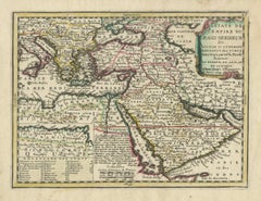
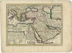
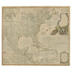
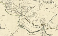
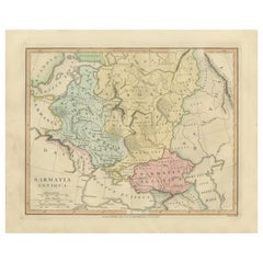
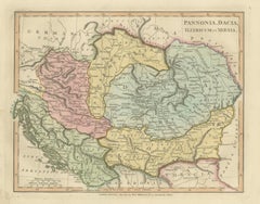
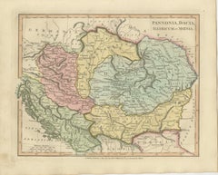
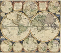
Ancient Pannonia & Dacia Map — Roman Balkans Provinces, Wilkinson 1823
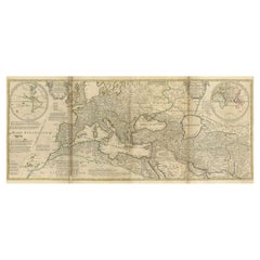
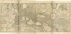
This finely engraved and beautifully hand-colored antique map depicts the Roman provinces of Pannonia, Dacia, Illyricum, and Moesia, covering a vast portion of Central and Southeastern Europe during antiquity. Published in London in 1823 by the noted English cartographer Robert Wilkinson, the map forms part of his celebrated classical atlas illustrating the geography of the ancient world through historical scholarship and archaeological interpretation.
The composition centers on the Danubian frontier of the Roman Empire, one of antiquity’s most strategically important regions. The Danube River (Danubius) winds prominently across the map, marking the northern defensive boundary of Roman civilization. Surrounding territories include parts of present-day Hungary, Austria, Croatia, Serbia, Romania, and Bulgaria, rendered according to classical geographic sources and Roman provincial organization.
Provincial borders are delicately highlighted in original hand color, distinguishing Pannonia, Dacia, Moesia, and Illyricum while maintaining a refined and harmonious palette typical of early nineteenth-century English atlas production. Mountain ranges, rivers, and ancient settlements are engraved with remarkable density and clarity, reflecting the period’s growing fascination with Roman military history and imperial administration.
The map illustrates regions closely associated with Roman expansion under emperors such as Trajan, whose conquest of Dacia represented one of the empire’s greatest territorial achievements. Numerous classical place names appear throughout, offering insight into Roman infrastructure, frontier settlements, and trade networks along the Balkans and Carpathian regions.
Wilkinson’s classical maps are admired today for combining academic precision with strong decorative appeal. Their balanced typography, elegant engraving style, and subtle coloring make them equally suitable for scholarly collections and refined interior design settings. This sheet, with its wide geographic scope and historical resonance, is particularly attractive for collectors interested in Roman history and European antiquity.
A sophisticated and historically rich decorative map appealing to collectors of classical cartography, Roman antiquity, and early nineteenth-century English atlas engraving.
Condition: Good antique condition overall. Light age-related toning and occasional spotting consistent with age. Minor edge wear and faint handling marks confined mainly to the margins. Plate mark visible.
Framing tips: Excellent in a dark walnut or antiqued gilt frame with a warm ivory mat. A generous mat enhances the soft hand coloring and allows the detailed provincial borders to remain visually calm and readable in both traditional and contemporary interiors.
Technique: Copperplate engraving with original hand color
Maker: Robert Wilkinson, London, 1823
keywords:
Pannonia, Dacia, Illyricum, Moesia, Danubius River, Roman Empire frontier, Balkans, Carpathian Mountains, Thracia, Macedonia, Germania, Sarmatia, Adriatic Sea, Danube frontier, Roman provinces map, Ancient Balkans, Roman military provinces, Trajan Dacia, Central Europe antiquity, Hungary, Croatia, Serbia, Romania, Bulgaria, Classical geography, Wilkinson Atlas 1823, Antique Roman map...
Category
Early 19th Century British Antique Maps