
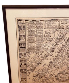
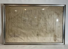
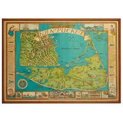
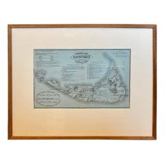
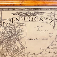
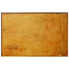
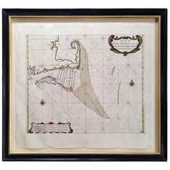
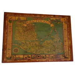
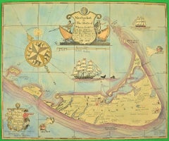
Tony Sarg Map of Nantucket Town, 1937
By Tony Sarg
Located in Nantucket, MA
Tony Sarg Map of Residential Main Street, Nantucket, 1937, a black and white printed map of our
Category
Vintage 1930s American Other Maps
Materials
Paper
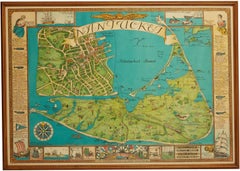
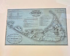
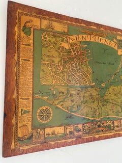
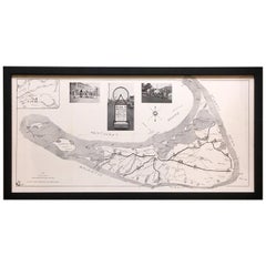
Tony Sarg Map of Nantucket Town, 1937
By Tony Sarg
Located in Nantucket, MA
Tony Sarg Map of Residential Main Street, Nantucket, 1937, a black and white printed map of our
Paper
$2,800
H 17 in W 19.63 in D 0.63 in
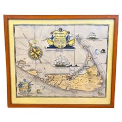
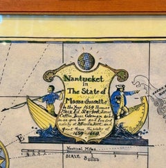
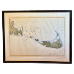
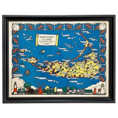
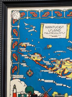
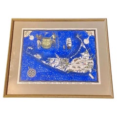
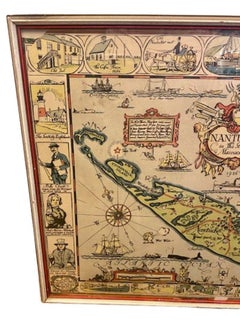
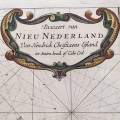
Hand Colored Map of Nantucket by Austin Strong (1881 - 1952), circa 1921
Located in Nantucket, MA
Map of Nantucket by Austin Strong (1881 - 1952), circa 1921, an original print on paper whimsical
Paper

$1,750
H 21.63 in W 36.25 in D 0.75 in
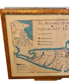
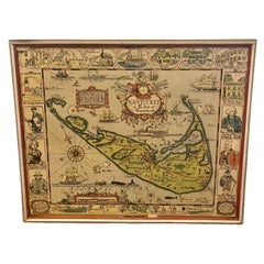
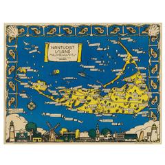
Nantucket High-Ways, By-Ways and Not-Ways Decorative Map by Tony Sarg, ca 1930
By Tony Sarg
Located in Nantucket, MA
Vintage Nantucket High-Ways, By-Ways and Not-Ways Decorative Map by Tony Sarg, (Nantucket: 1880
Paper

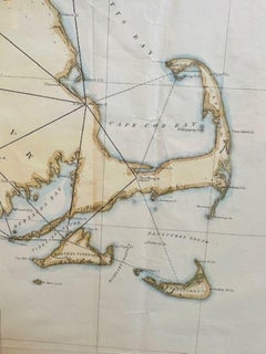
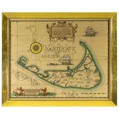
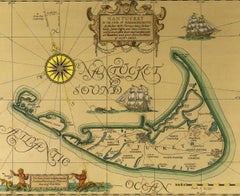
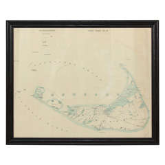
1873 Martha's Vineyard and Nantucket Chart
Located in Norwell, MA
Original chart of Nantucket and Martha's Vineyard by George Eldridge, Cartographer, 125 State
Paper
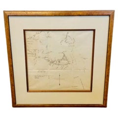
DesBarres (1776) Chart of Nantucket Island, 1966 Restrike
Located in Nantucket, MA
and revised the charts up to 1781 (and possibly later). This was the first published map of Nantucket
Paper

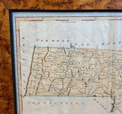
18th Century Hand Colored Map of The State of Massachusetts, 1796
Located in Nantucket, MA
18th Century Hand Colored Map of "The State of Massachusetts from the best information," 1796, by
Paper

19th Century Chart of New England Coast, 1847
By U.S. Government
Located in Nantucket, MA
Nantucket to Passamaquoddy Bay, published in 1847. This is a scarce transitional chart updated and
Paper
$2,400
H 20.75 in W 26.5 in
Maps of Nantucket Sound and Harbor Provenance: The Susie Hilfiger Collection
Located in Bristol, CT
Map Sz: 22 1/2"H x 17"W Frame Sz: 26 1/2"H x 20 3/4"W *w/ age toning/ slight creasing/ waving to
Paper
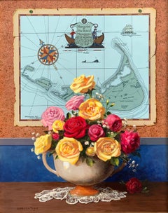
Nantucket Roses
By Jenness Cortez
Located in Greenwich, CT
Arrangement of roses in front of a map of Nantucket
Mahogany, Acrylic

Nantucket Peonies
By Jenness Cortez
Located in Greenwich, CT
Still life of a vase full of peonies in front of a map of Nantucket.
Mahogany, Acrylic

$2,100
H 19 in Dm 24 in
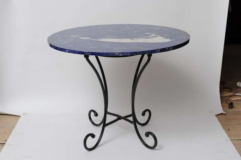
Inlay Lapis, Mother-of-Pearl & Marble Pietra Dura Map of Nantucket on Iron Base
Located in Nantucket, MA
A fabulous detailed map of Nantucket made of marble, mother-of-pearl and lapis lazuli with a mother
Lapis Lazuli, Marble, Iron


Tony Sarg Folk Art Bridal Box, circa 1920
Located in Nantucket, MA
boxes and other folk art. He is especially remembered on-island for his maps, posters and Nantucket
Composition
Vintage Nantucket Map with Original Wood Frame
Located in New York City, NY
Vintage map of Nantucket. Mid-20th century in original wood frame.
Wood, Paper
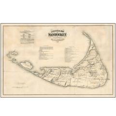
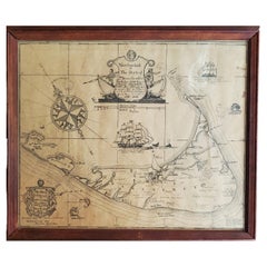
Original Antique 1869 Wall Map of Nantucket
Located in La Jolla, CA
Nice example of the wall map version of Reverend F.C. Ewer's Historical Map of Nantucket. The
Paper
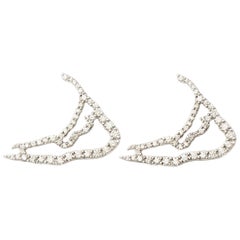
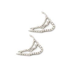
Susan Lister Locke Nantucket in Diamonds Map Earrings
By Susan Lister Locke
Located in Nantucket, MA
The shape of Nantucket Island is as iconic as the island itself. From the Diamond Island™
Diamond, 18k Gold, White Gold, Palladium
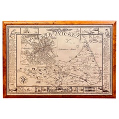
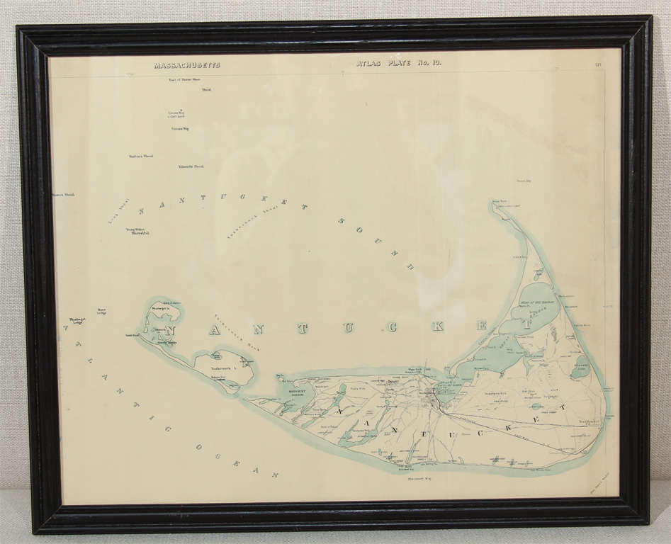
19th Century Nantucket Map by Rev, Ewer, circa 1886
Located in Nantucket, MA
19th century Nantucket map by Rev, Ewer, circa 1886, a small version of Ewer's celebrated 1869
Paper
Sold
H 21 in W 29.5 in D 2 in
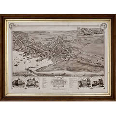
"Bird's-Eye or Aerial View of Nantucket, " Aerial View of Nantucket, 1881
By J.J. Stoner 1
Located in Nantucket, MA
"Birds Eye View of the Town of Nantucket" map depicting accurate views of all the houses on the
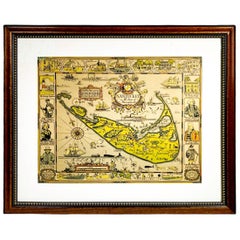
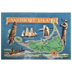
Whimsical Decorative Map of Nantucket by Jack Atherton, 1937
Located in Nantucket, MA
A wonderful vintage pictorial map of Nantucket Island, by Jack Atherton, 1937, simple and whimsical
Paper
Vintage Map of Nantucket Town by Ruth Haviland Sutton, 1946
Located in Nantucket, MA
Vintage Map of Nantucket Town by Ruth Haviland Sutton, 1946, a classic vintage tourist map of
Paper
Vintage Whimsical Map of Nantucket Island by Fred Gardner, 1933.
Located in Nantucket, MA
Vintage Whimsical Map of Nantucket Island by Fred Gardner, 1933, a classic tourist map from the
Paper

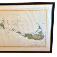
Map of Nantucket by Austin Strong '1881-1952', circa 1925
Located in Nantucket, MA
Map of Nantucket by Austin Strong (1881 - 1952), circa 1925, an original print on paper whimsical
Paper

19th Century Chart Map of Martha's Vineyard and Nantucket Shoals
Located in Rio Vista, CA
Large, rustic antique map of Martha's Vineyard Sound and Nantucket Shoals mounted on board and
Wood, Paper
Tony Sarg Hand Colored Whimsical Map of Nantucket, circa 1926
By Tony Sarg
Located in Nantucket, MA
Antique Tony Sarg Hand Colored Whimsical Map of Nantucket, circa 1926, a decorative colored folk
Paint

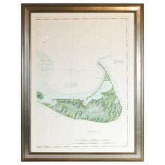
19th Century Chart of Nantucket
Located in Nantucket, MA
Extremely Rare 19th Century Chart of Nantucket. circa 1850, with details of Nantucket Island
Paper
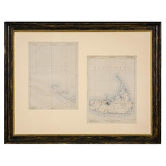
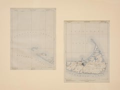
Nantucket Chart Map
Located in Nantucket, MA
Set of two U.S. geological survey topographical chart maps, one of Nantucket, the other Muskeget
Paper
Vintage Map of Nantucket
Located in Nantucket, MA
Hand colored map of Nantucket Island, decorated with small illustrations of clipper ships, a
Roggeveen's Hand Colored Chart of Cape Cod and the Islands, 1675
By Arent Roggeveen
Located in Nantucket, MA
, period hand coloring, showing Cape Cod, Martha’s Vineyard and Nantucket, with coastal detail, depth
Paper
Map of Nantucket by Tony Sarg, 1926
By Tony Sarg
Located in Nantucket, MA
Colored pictorial map of Nantucket in the State of Massachusetts, with central image of the Island
Paper
Hand Colored Map of Nantucket by Sol Levenson, 1981
By Sol Levenson
Located in Nantucket, MA
Vintage hand colored map of Nantucket by Sol Levenson (1910-2006), an extremely rare decorative map
Paper
Map of Nantucket, Ruth Haviland Sutton, Published by Miller, 1964
Located in Nantucket, MA
Vintage map of Nantucket, by Ruth Haviland Sutton (Nantucket: 1898-1960), published by Miller, 1964
Plywood, Paper

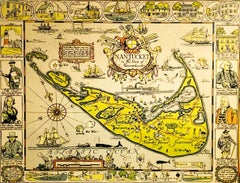
Rare Decorative Map of Nantucket Designed Jack Atherton, circa 1937
Located in Nantucket, MA
Jack (Bonney) Atherton. A decorative map of Nantucket Island, Massachusetts. LeBaron-Bonney Co

American Neptune Chart of Nantucket
Located in Norwell, MA
Framed map showing Nantucket Island with major ponts noted. Printed mileage legend on bottom. Also

Small Nantucket Keepsake by Tony Sarg
By Tony Sarg
Located in Nantucket, MA
1926 map of Nantucket, circa 1930s Measures: 3 ¼” x 6 3/8” x 3 ½”.
Pine
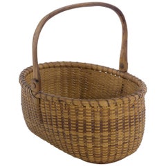

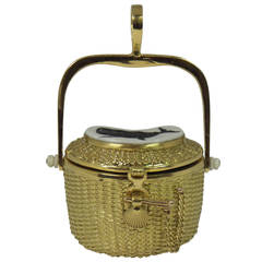
Oval Nantucket Lightship Basket by Jose Reyes
By Jose Formoso Reyes
Located in Nantucket, MA
Open oval Nantucket Lightship Basket woven without a mold. Measure: 9 ½”. Having a oak swing handle
Reed, Oak, Pine


1907 Chart of Nantucket Harbor by George Eldridge
Located in Norwell, MA
Chart of Nantucket Harbor from 1907 by cartographer George W. Eldridge. The chart shows the channel
Paper

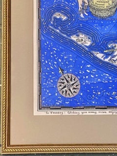
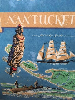
"Watercolor 1921 Map of Nantucket"
Located in Bristol, CT
1940s. He designed a map of Nantucket in 1921, the sale of which generated substantial funds for the
Watercolor

Tony Sarg Bicycle Map of Nantucket, 1930s
By Tony Sarg
Located in Nantucket, MA
Very rare young's bicycle shop map of Nantucket, by noted folk artist/author/puppeteer Tony Sarg
Paper

Sold
H 30.5 in W 27 in
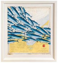
Nantucket Mack Pack - A Gathering of Mackerel on a Vintage Nautical Map
By Jeff Conroy
Located in Chicago, IL
on this stunning species. Drawn on a vintage nautical map adds to the overall aesthetic. The piece
Paper, Watercolor
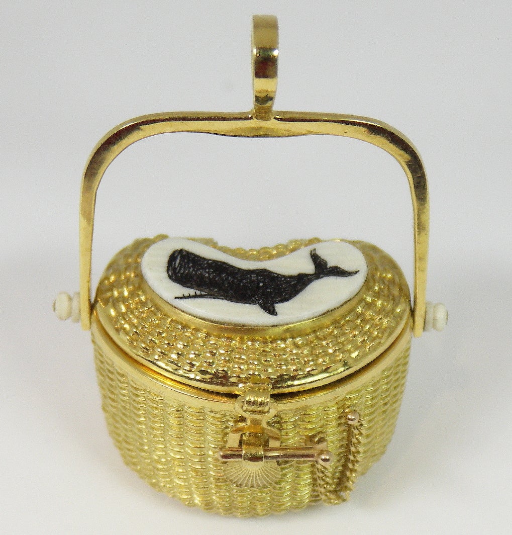
Diana Kim England Nantucket Basket Pendant
By Diana Kim England
Located in Palm Beach, FL
An 18K yellow gold pendant by Diana Kim England. With a unique kidney shape, this Nantucket basket
18k Gold
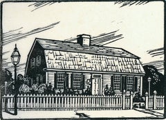
Cape Cod Cottage
By Ruth Haviland Sutton
Located in Plano, TX
frequently reproduced works including a map of Nantucket, and a print of famous island attractions. Sutton
Woodcut
Sold
nantucket map
Located in Seattle, WA
very rare map... we have only found a few... this one will not last. pale turquoise on creamy
Paper, Wood
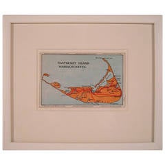
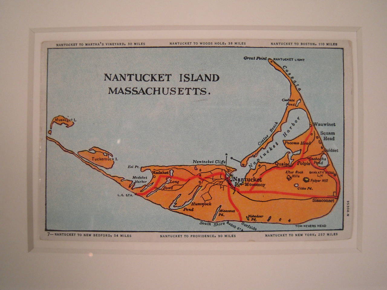
Nantucket Island Map
Located in Essex, MA
A vintage map postcard of Nantucket, circa 1952, printed in orange and red on light blue with black
Paper

“Straight Wharf Nantucket”
Located in Southampton, NY
Original off set lithograph in black and white with hand colored tinting by the artist. Artist signed, titled and numbered by the artist 47/250. Condition is excellent. Under glass...
Archival Paper, Lithograph

$1,196Sale Price|20% Off
H 19 in W 23 in D 2 in
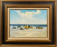
Antique American School Summer Beach Scene Framed Impressionist Oil Painting
Located in Buffalo, NY
Antique American impressionist seascape beach scene oil painting. Oil on board. No signature found. Framed. Image size, 18L x 14H.
Canvas, Oil
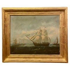
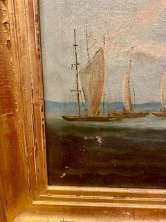
19th Century Seascape with Brig Under Full Sail
Located in Nantucket, MA
19th Century Seascape with Brig Under Full Sail, British School, circa 1870, an oil on canvas seascape with a square-rigged Brig under sail on the high seas, with several fishing lug...
Canvas
$18,000
H 18.25 in W 34.25 in D 4 in
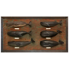
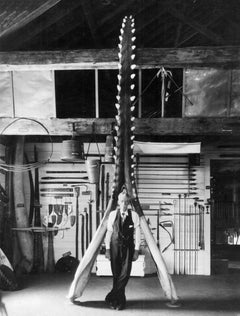
Carved and Painted Six Whale Species Board Made by Nantucket Whaler, circa 1940
By Captain George Grant
Located in Nantucket, MA
Made by George Grant of Nantucket (1857-1942). Grant, the son of whaling captain Charles Grant, was born in 1857 during a whaling voyage. His mother, Nancy Grant traveled with her h...
Pine, Paint

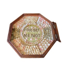
19th Century Double Sailor's Valentine
Located in Nantucket, MA
Antique Double Sailor's Valentine, circa 1880, a pair of handcrafted shell collages mounted in mahogany octagonal shadowboxes, hinged together and mounted with a clasp and a chain fo...
Shell, Mahogany
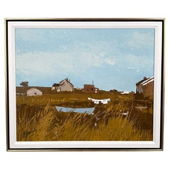

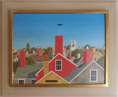
Nantucket Autumn Painting by Andrew Shunney
By Andrew Shunney
Located in Sandwich, MA
Vintage painting "Nantucket Autumn" by Andrew Shunney (American: 1916 - 1978), circa 1960s. Acrylic on canvas modern minimalist Nantucket autumnal landscape with marsh, creek and cot...
Acrylic
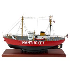
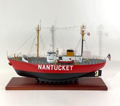
Nantucket Lightship 612 Scale Model
Located in Norwell, MA
Scale model of the Nantucket lightship. This is the Lightship 612 that is now owned by Bill Golden. The model was professionally built for the person we acquired it from. Precisely d...
Wood
$1,200
H 25.25 in W 33.25 in D 2 in
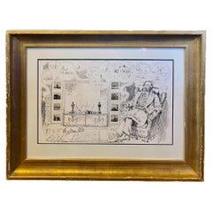
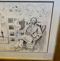
Print of Nantucket Daydreams, by Henry S. Wyer, Nantucket, circa 1900
Located in Nantucket, MA
Antique Print of Nantucket Daydreams, by Henry S. Wyer, Nantucket, circa 1900, a period print depicting a gentleman in overstuffed wing chair by the hearth, a copy of Nantucket's "In...
Paper

"Nantucket"
By Paul Crosthwaite
Located in Lambertville, NJ
Signed Lower Left Paul Crosthwaite (1911 - 1981) Paul Crosthwaite was a respected member of the New Hope art community. He was born in Pelham Manor, New York and after studying in ...
Oil, Panel