Items Similar to Vintage Map of Nantucket Town by Ruth Haviland Sutton, 1946

Want more images or videos?
Request additional images or videos from the seller
1 of 8
Vintage Map of Nantucket Town by Ruth Haviland Sutton, 1946
About the Item
Vintage Map of Nantucket Town by Ruth Haviland Sutton, 1946, a classic vintage tourist map of Nantucket Island showing historic landmarks and geographic details along with decorative images, and featuring an enlargement of Nantucket Town with street plan; the perimeter features a series of iconic images and factual notes from Nantucket's history; signed in print lower left "Planned and Drawn by Ruth Haviland Sutton 1946, lithographed by George C. Miller."
The map is in mint collection having been kept in archival storage since it was printed in the estate of Nantucket photographer and shop keeper Marshall Gardiner. It has been recently mounted and framed in a bird's eye maple frame.
Measures: 22-3/4 in H x 31-3/4 in W
Framed: 25-1/4 in H x 34-1/8 in W
About the Seller
5.0
Platinum Seller
These expertly vetted sellers are 1stDibs' most experienced sellers and are rated highest by our customers.
1stDibs seller since 2010
239 sales on 1stDibs
Typical response time: 1 hour
- ShippingRetrieving quote...Ships From: Nantucket, MA
- Return PolicyA return for this item may be initiated within 3 days of delivery.
More From This SellerView All
- Hand Colored Photograph of Nantucket Street Scene by Marshall Gardiner, Ca 1910Located in Nantucket, MAAntique Hand Colored Photograph of Nantucket Street Scene by Marshall Gardiner (1884-1942), circa 1910, a period hand tinted photograph entitled "Nantucket Shearing Cart and Quakers" showing classic grey shingled houses on a cobblestone paved street, with a couple in horse drawn cart riding away from the viewer, and four women on doorstep and sidewalk, all dressed in period Quaker attire. It is interesting to note that the couple in cart are seated on antique Nantucket Bow Back Windsor chairs. The photograph was titled and hand signed in pencil across the bottom of the old acid foxed mat; the photograph is now mounted in new archival acid free matting, and a photocopy of the original pencil inscription has been preserved on the reverse. The photograph itself remains in excellent condition. H. Marshall Gardiner (1884-1942) was born on September 18, 1884 in Windsor, Ontario, and immigrated to the United States circa 1890, where his father W.H. Gardiner opened two photographic studios, one in Detroit during the winter months and a second at Mackinac Island during the more tourist-oriented summer months. Recognizing the potential of Florida's rapidly growing tourist trade, around 1894-95 he moved with his family from Detroit to Daytona, Florida which proved much more accommodating to the family's photographic business during the colder winter months. Marshall learned many of his photographic techniques from his father prior to going out on his own at a relatively early age. Whereas his father generally used wet collodian negatives, technology had advanced to where he was able to use gelatin dry plates in his earlier years, and later the less expensive and much more convenient roll film. Another very important lesson learned from his father was strategy of setting up shop in a tourist resort. Early in his career he traveled to Bermuda where he shot a series of beautiful Bermuda scenes that he hand-colored and successfully sold over a number of years to the local tourist trade. Around 1910, at the age of around 24, he first traveled to the island of Nantucket. The year-round population of Nantucket was then just over 2500, not nearly enough to sustain a photographic business for the entire year, so he opened a joint Photography and Art Supplies Store. Working as Nantucket's exclusive agent for Eastman Kodak, his business expanded to include the island's only photo-finishing service. However, with such a small year-round population, even the addition of a Gift Shop to compliment the hand-painted photographs, general portrait...Category
Early 20th Century American Other Photography
MaterialsPaper
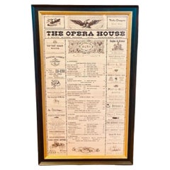
- Nantucket Opera House Menu, circa 1960s to 1970sLocated in Nantucket, MARare Vintage Menu from the Opera House Restaurant on Nantucket, circa 1960s. The beloved and fondly missed Opera House was the iconic restaurant owned and operated by Gwen Gaillard o...Category
Vintage 1960s American Other Historical Memorabilia
MaterialsPaper
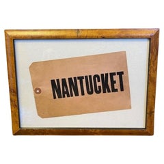
- Nantucket Steamship Luggage Tag, circa 1920sLocated in Nantucket, MAAntique Nantucket Steamship Luggage Tag, circa 1920s, heavy stock paper or card in faded red with the printed inscription "NANTUCKET." This is the last of a stash found in an attic on Nantucket. The tag is in excellent condition, with the color delightfully faded to what is popularly known today as "Nantucket Red...Category
Early 20th Century American Industrial Historical Memorabilia
MaterialsPaper
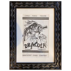
- Original Program for Nantucket Stage Production Dracula, Signed by Edward GoreyLocated in Nantucket, MAOriginal program for the Nantucket Stage Company Production of "Dracula", signed by Edward Gorey, 1973. The Nantucket Stage Company (which became the Stra...Category
Vintage 1970s American Post-Modern Historical Memorabilia
MaterialsPaper
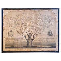
- 19th Century Mayhew Family Tree from Nantucket and Martha's Vineyard from 1855Located in Nantucket, MAVery rare 19th century Mayhew Family tree from Nantucket and Martha's Vineyard, lithograph on paper laid on linen, printed in 1855, in form of liter...Category
Antique 1850s American Other Historical Memorabilia
MaterialsPaper, Linen
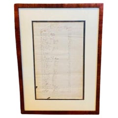
- Late 18th Century Nantucket Brant Point Lighthouse Ledger PageLocated in Nantucket, MAExtremely Rare an Important Late 18th Century Nantucket Lighthouse Ledger Page documenting Subscriptions and Donations to rebuild the Brant Point Lighthouse on Nantucket. Brant Point...Category
Antique Late 18th Century American American Colonial Historical Memorabilia
MaterialsPaper

You May Also Like
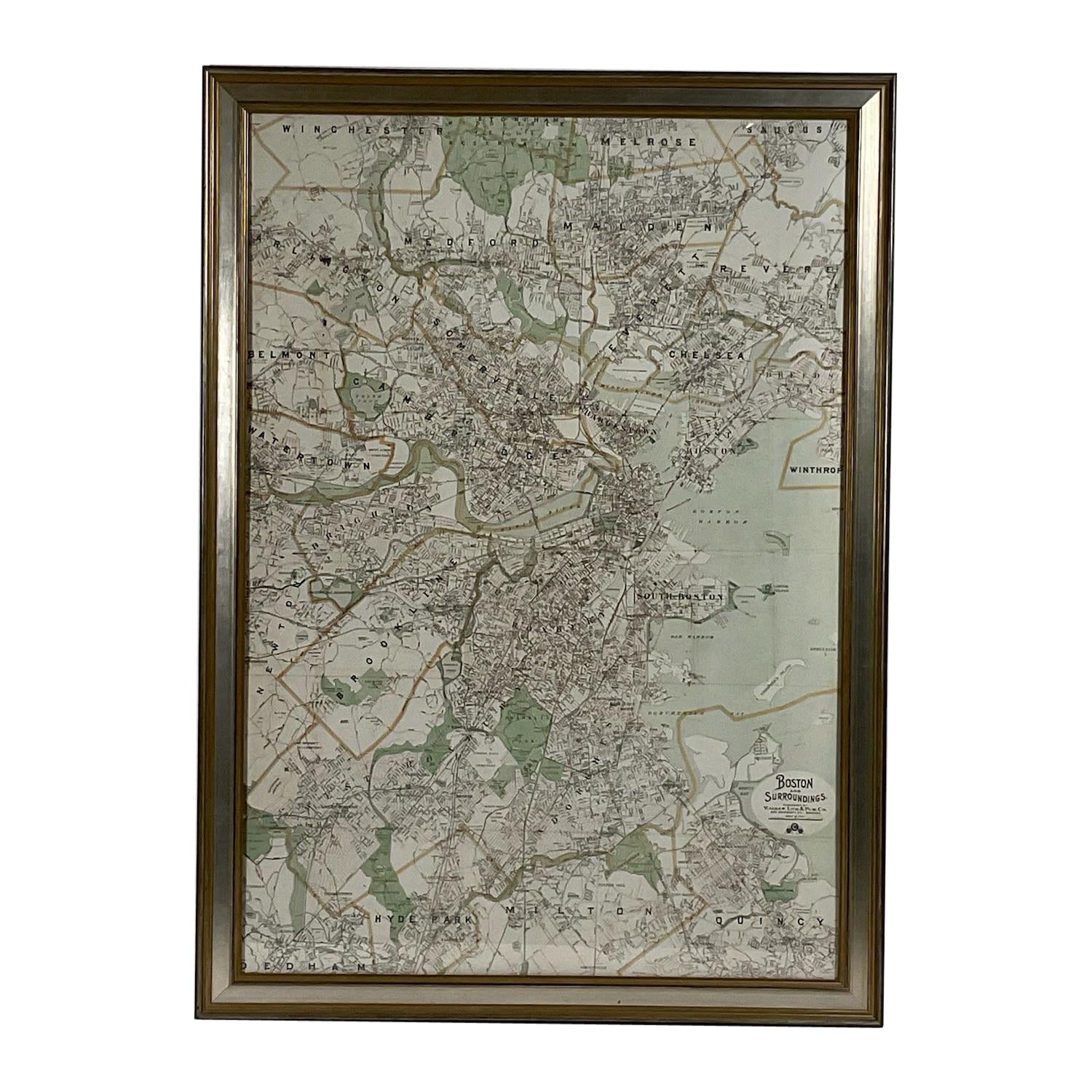
- Map of Boston and Surrounding TownsLocated in Norwell, MALater copy of a nineteenth century map of Boston and surrounding towns. Showing parts of Quincy, Milton, Hyde Park, Winthrop and Revere. Showing all of B...Category
Antique 19th Century North American Maps
MaterialsPaper
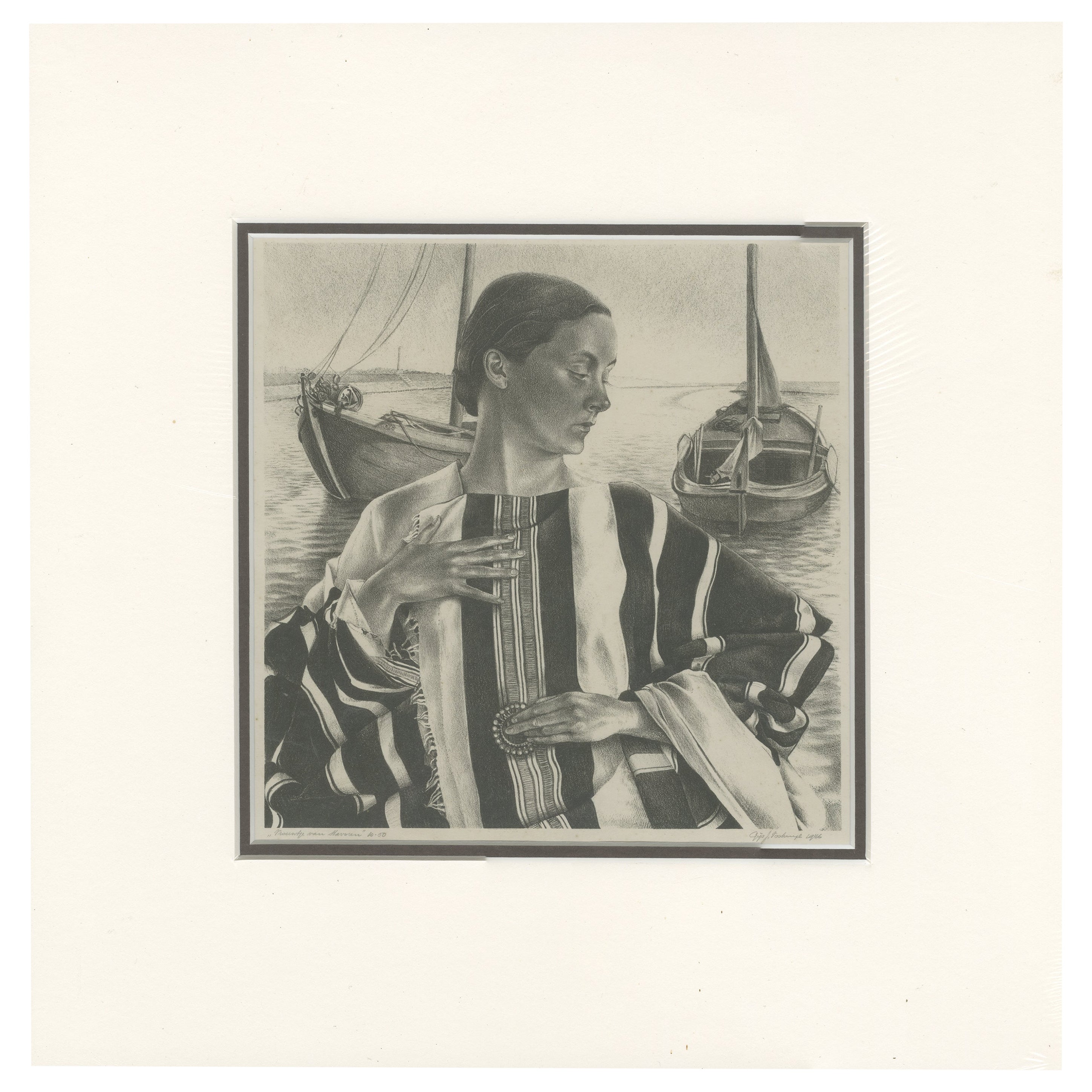
- Vintage Print of the Lady of Stavoren by Voskuijl, 1946Located in Langweer, NLVintage lithograph titled 'Vrouwtje van Stavoren'. Lithograph of the Lady of Stavoren, a folk tale from the Netherlands which originated in the 16th century. Published 1946. Arti...Category
20th Century Maps
MaterialsPaper
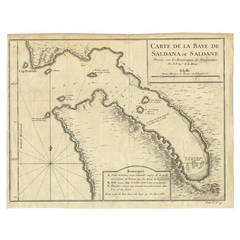
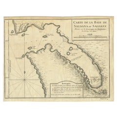
- Antique Map of Saldanha Bay 'Near Cape Town, South Africa' by Bellin, 1750By Jacques-Nicolas BellinLocated in Langweer, NLAntique map titled ‘Carte De La Baye De Saldana ou Saldane Dressee sur les Remarques des Navigateurs’. Detailed plan of Saldanha Bay, northwest of Cape Town, South Africa. This map o...Category
Antique 18th Century Maps
MaterialsPaper
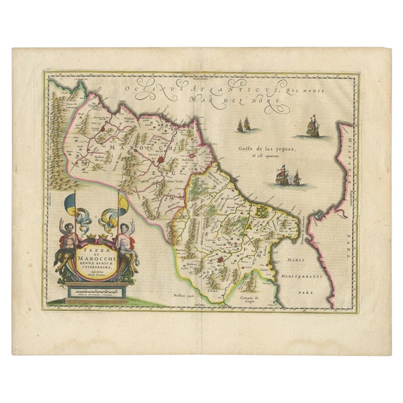
- Antique Map of Morocco Showing Towns of Marakesh, Taradant and Fez, 1636Located in Langweer, NLAntique map titled 'Fezzae et Marocchi regna Africae Celeberrima'. Map of Morocco, showing large fortified towns of Marakesh, Taradante and Fez, towns, mountains, rivers, lakes, etc....Category
Antique 17th Century Maps
MaterialsPaper
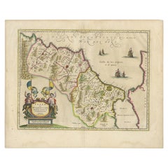
- Antique Map of Denmark with Details of Fortresses, Cities, Towns Etc, c.1680Located in Langweer, NLAntique map of Denmark titled 'Insularum Danicarum ut Zee-Landiae, Fioniae, Langelandiae, Lalandiae Falstriae, Fembriae, Monae (..)'. This map depicts the main Danish Islands and a s...Category
Antique 17th Century Maps
MaterialsPaper
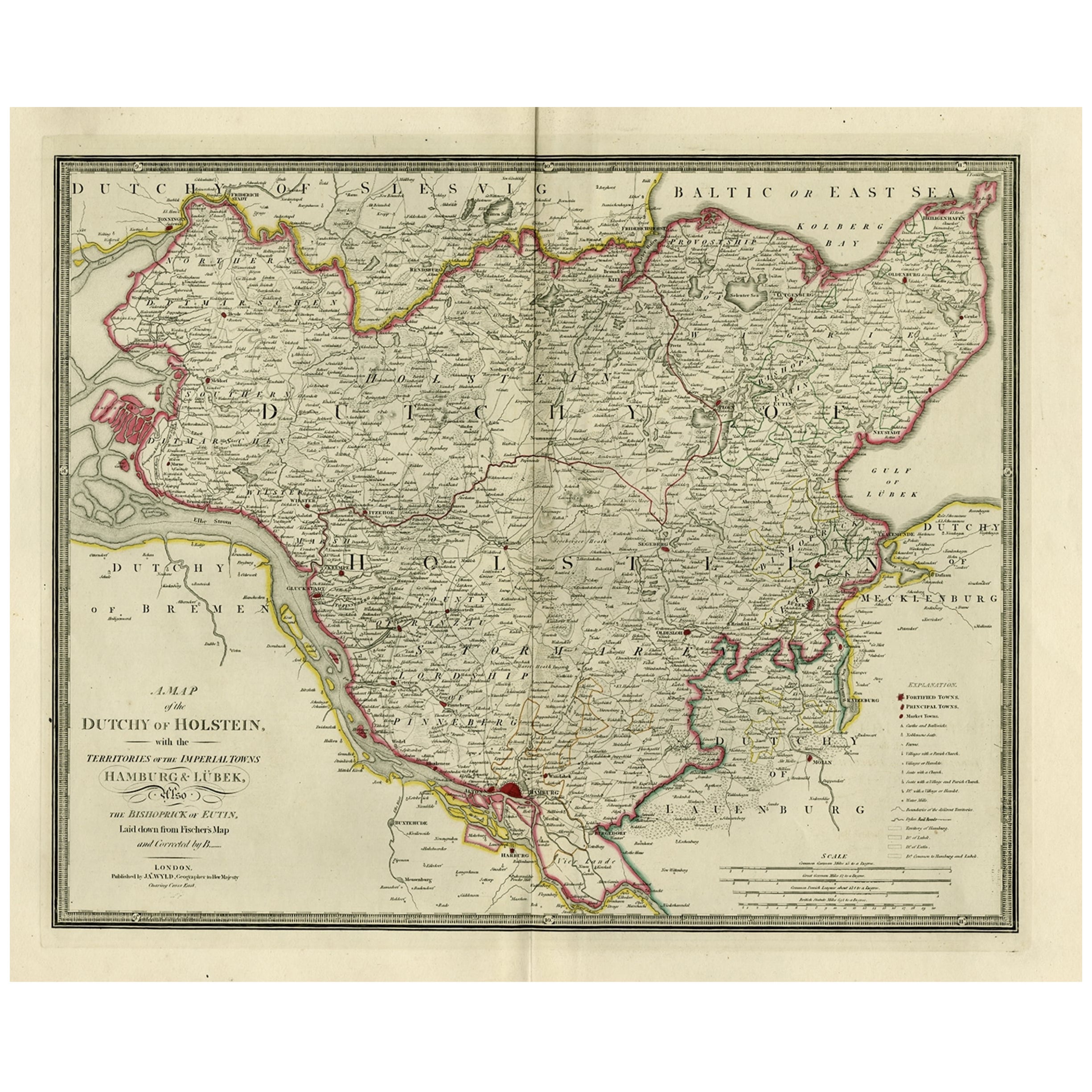
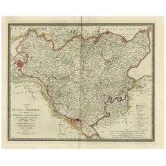
- Old Map of Holstein with the Imperial Towns Hamburg & Lubeck, Germany, 1854Located in Langweer, NLAntique map titled 'Map of the Duchy of Holstein with the territories of the Imperial Towns Hamburg & Lubeck (..) Based on a map by Fischer.' Map of the Duchy of Holstein. From Jam...Category
Antique 1850s Maps
MaterialsPaper


Recently Viewed
View AllMore Ways To Browse
18th Century European Maps
Old Prints Of Maps
Clivia Ducatus Et Ravestein Dominium
Arkansas Indian Map
Historical Balkan Map
Indian Territory Maps
Op Ocean Pacific
Brabant Map
Old Teak Petite Artisan
Antique Map Of New Hampshire
Antique Maps Perth
Atlas Indu
Giovanni Maria Cassini On Sale
Kiribati Islands Map
Oman Map
Palliser Furniture
Barbados Map
Dan Rizzi