Nova Totius Terrarum Orbis Tabula
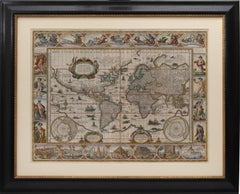
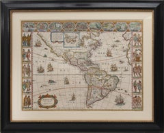
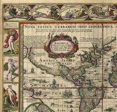
Nova Totius Terrarum Orbis Geographica Ac Hydrographica Tabula
Located in New York, NY
Copper-plate engraving, hand-colored, 1608 - c.1630 and published by Joannes Jansonius, Amsterdam. Image size 15.75 x 21.19 inches (40 x 53.9 cm).
A classic example of a world ma...
Category
17th Century Other Art Style More Art
Materials
Engraving
People Also Browsed
Extensive Assembled Meissen Blue and White Bird Model Dinner Service, circa 1890
Located in New York, NY
Each piece painted in underglaze-blue and heightened in gilding with an exotic bird perched upon peony branches, comprising: an oval soup tureen, cover and two stands, an 18" oval pl...
Category
Antique 1890s German Dinner Plates
Materials
Porcelain
Compass with Pocket Sundial, with Case, Bronze, Butterfield, Michael '1635-1724'
Located in Madrid, ES
Compass with pocket sundial, with case. Bronze. BUTTERFIELD, Michael (1635-1724). Paris, circa 1700.
Pocket sundial made of engraved metal, with a gnomon in the shape of a bird wit...
Category
Antique Early 18th Century French Neoclassical Scientific Instruments
Materials
Metal, Bronze, Other
H 2.96 in W 3.35 in D 0.79 in
French 19th Century Gilt Barometer
Located in Baton Rouge, LA
A delightful 19th Century French gold-gilt barometer circa 1850. This early instrument of meteorology has been adorned with a molded and decoratively trimmed octagonal frame dotted ...
Category
Antique 19th Century French Louis XVI Decorative Art
Materials
Wood, Paper
WWI brass Carl Zeiss Jena "Fussartillerie" artillery compass
Located in London, GB
A WWI brass Carl Zeiss Jena "Fussartillerie" artillery compass.
3¾ inch dial marked with N W S points, the Carl Zeiss Jena logo, and B.R. 565 FUSSARTILLERIE.
Compass ring marked ...
Category
Early 20th Century German Scientific Instruments
Materials
Brass, Bronze
WORLD MAP - Planisphaerium Terrestre Sive Terrarum Orbis... 1696
By Carel Allard
Located in Santa Monica, CA
CAREL ALLARD (1648 – 1709)
PLANISPHAERIUM TERRESTRE SIVE TERRARUM ORBIS… 1696 (Shirley 578)
Engraving, 20 ½ x 23 ½”, sheet 21 x 24 1/8". A stunning double hem...
Category
17th Century Old Masters Landscape Prints
Materials
Engraving
Sundial and Compass with Case, Schrettegger, Johan, Augsburg, Germany, Ca 1800
Located in Madrid, ES
Sundial and compass with case. Bronze. SCHRETTEGGER, Johan. Augsburg, Germany, around 1800.
Sundial with a polygonal shape made of bronze, engraved with plant elements on the front,...
Category
Antique Late 18th Century German Neoclassical Scientific Instruments
Materials
Bronze, Other
H 2.76 in W 2.56 in D 0.79 in
12 Sevres Louis Philippe Plates After The Originals- Chateau De Fontainebleau
Located in Bridgeport, CT
Sevres Porcelain plates, after Louis Philippe Royal Hunting Service, France, polychrome decorated, transfer printed, and with gilt star centers, hunting border motif featuring eagles...
Category
Antique 19th Century French Louis Philippe Dinner Plates
Materials
Porcelain
Planiglobii Terrestris Mappa Universalis / Mappe Monde
By Homann Heirs
Located in New York, NY
This map was printed from a copperplate engraving in 1746. The printed image size is 18.25 x 21.75 inches (46.3 x 55.2 cm) plus margins.
An attractive double hemisphere map of the w...
Category
18th Century Other Art Style More Prints
Materials
Engraving
H 20.13 in W 23.88 in D 0.94 in
17th Century Spanish Burled Walnut Vargueno or Collectors Cabinet
Located in Milford, NH
A fine example of a diminutive burled walnut vargueno, collector or valuables cabinet, with molded cornice and drop front, opening to a multi-drawer interior with two fitted upper dr...
Category
Antique 17th Century Spanish Moorish Cabinets
Materials
Brass, Wrought Iron
Map Road John Ogilby Britannia No 74 Ipswich to Norwich Cromer Framed
By John Ogilby
Located in BUNGAY, SUFFOLK
The Road from Ipswich com Suffolk to Norwich and thence to cromer on the sea coast com Norfolk. By John Ogilby, Esq, His Majesties Cosmographer. Containing 66 miles, 4 furlongs. No 7...
Category
Antique 1670s English Baroque Maps
Materials
Paper
“Dawn and Rooster" Daum Nancy Art Nouveau Glass Vase, circa 1897
By Daum
Located in Saint-Ouen, FR
Dawn and Rooster Daum Nancy Vase 1897
Opalescent glass vase with and hand-painted polychromatic enameled decor gold highlighted on an acid frosted background with rising sun and cam...
Category
Antique 1890s French Art Nouveau Glass
Materials
Art Glass
A NEW MAP OF THE WORLD from the Latest Observations.
By John Senex
Located in New York, NY
The title continues “…. Most Humbly Inscribd [sic] to his Royal Highness George Prince of Wales.”
A fine British produced double hemisphere world map. On this map, California is sh...
Category
18th Century Other Art Style More Prints
Materials
Watercolor, Engraving
H 20.75 in W 23.75 in D 0.94 in
Road Map, John Ogilby, No 54, London, Yarmouth, Britannia
By John Ogilby
Located in BUNGAY, SUFFOLK
The Road from London to Yarmouth com. Norfolk. By John Ogilby, His Majesties Cosmographer. Containing 122 miles, 5 furlongs. No 54.
From Standard in Cornhil London to Colchester....
Category
Antique 1670s English Baroque Maps
Materials
Paper
Road Map John Ogilby No 75 Kings Lyn Harwich, Britannia Framed Wallhanging
By John Ogilby
Located in BUNGAY, SUFFOLK
The Road from Kings Lyn Co Norfolk to Harwich Co Essex. By John Ogilby His Majesties Cosmographer. Containing 76 miles, 1 furlong.
From Lyn to Swaffam, to Stanford, to Thetford, ...
Category
Antique 1670s European Baroque Maps
Materials
Paper
H 15.75 in W 19.69 in D 0.6 in
Antique Double Hemisphere World Map with California as an Island, 1710
Located in Langweer, NL
Description: Antique map titled 'De Werelt Caart'. First state (out of three) antique double hemisphere world map from a Dutch bible by Cornelis Dankerts (Danckerts), engraved by Alb...
Category
Antique 1710s Maps
Materials
Paper
2 Antique Framed Emanuel Sweert Florigriums Botanical Latin Plant Engravings
By Emanuel Sweert
Located in Dayton, OH
Pair of antique Emanuel Sweert Florilegium floral botany plant bulb engravings. Plates 32 and 67.
32. Pancralim orientals, pancratium occidentalis.
67. Narc. Promont. bona fpei...
Category
Early 20th Century Prints
Materials
Paper
H 22 in W 16.5 in D 1 in
Recent Sales
Set of World & Four Continents
By Joan (Johannes) Blaeu
Located in London, GB
Totius Terrarum Orbis Tabula; Americæ nova Tabula; Asia noviter delineata; Africæ nova descriptio; Europa
Category
17th Century More Art
Materials
Watercolor, Engraving
Get Updated with New Arrivals
Save "Nova Totius Terrarum Orbis Tabula", and we’ll notify you when there are new listings in this category.
More Ways To Browse
Antique Wonders
Four Seasons Panels
Antique Plyers
17th Century German Engravings
Antique Compass Art
Mercator Antique
Antique Sun And Moon
Indigenous Panel
Sun And Moon Plates
Allegorical Engraving
Antique Ac
Europa 2
World Map Antique Style
World Maps Antique Style
Antique Style Map Of The World
Compass Rose Gold
Ancient Wonders Of The World
Joan Blaeu