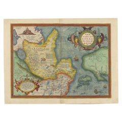
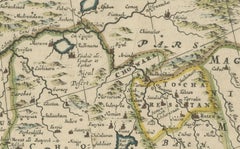
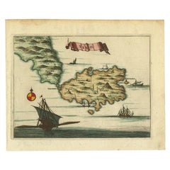
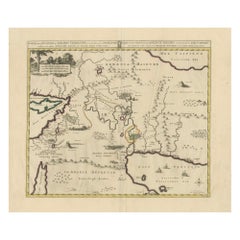
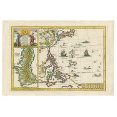
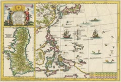
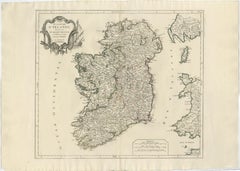
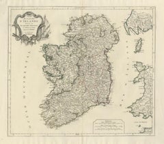
Antique Map of Ireland – Royaume d’Irlande, Robert de Vaugondy, Venice 1778
Description:
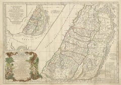
This finely engraved 18th-century map depicts the Kingdom of Ireland under the title Royaume d’Irlande divisé en ses quatre Provinces et subdivisé en Comtés. The island is shown in impressive detail, with the traditional four provinces—Ulster, Connaught, Leinster, and Munster—clearly delineated and subdivided into counties by contemporary outline coloring. Coastal features, rivers, towns, and road networks are rendered with the clarity and balance typical of late Enlightenment French cartography.
The map was drawn by Robert de Vaugondy, one of the most influential mapmakers of the 18th century and royal geographer to the King of France. This Venetian edition was published in 1778 by Paolo Santini, who issued a number of high-quality Italian editions of leading French cartographic works. Santini’s publications are prized for their crisp engraving, generous format, and restrained coloring, making them particularly attractive for framing.
The decorative maritime cartouche, left uncolored as issued, provides a refined visual counterbalance to the densely engraved map surface. Longitude and latitude scales frame the composition, while inset coastal details along the eastern seaboard emphasize Ireland’s maritime orientation and strategic importance during the Georgian period. The overall aesthetic is elegant rather than ornate, lending the map strong decorative appeal for both classic and contemporary interiors.
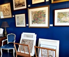
This map sits at the intersection of political geography and decorative cartography, reflecting Ireland’s administrative structure in the late 18th century while remaining visually calm and highly legible. It works exceptionally well as a stand-alone wall piece in libraries, studies, hallways, or heritage-inspired interiors, and also pairs beautifully with maps of England or Scotland from the same period.
Condition report:
Good antique condition. Light, even age toning throughout. Original centerfold as issued. Minor handling wear and soft creases consistent with age. Contemporary outline coloring well preserved. No major tears or losses.
Framing tips:
This map benefits from a wide mat to emphasize its scale and clarity. Recommended combinations include a dark walnut or ebonized frame with an ivory or light parchment mat for a traditional library look, or a slim black frame with an off-white mat for a cleaner, architectural presentation. UV glass is advised to preserve the original coloring.
Technique: Copper engraving with contemporary outline coloring
Maker: Robert de Vaugondy, published by Paolo Santini, Venice, 1778
Keywords:
antique map of Ireland, antique Ireland map, Royaume d’Irlande map, Robert de Vaugondy Ireland, Santini Venice map, 18th century Ireland map, hand colored antique map, Georgian era cartography, historic Ireland wall map, European antique map, French cartographic school, Italian engraved map, copper engraved map, decorative antique map, neutral antique wall art, classic library wall decor, historic wall decor, heritage interior art, gentleman’s library wall art, study wall decor, old world interior decor, English country house style, refined wall map, vintage European wall art, timeless wall decor, architectural interior art, framed antique map...
Category
1770s Italian Antique Maps