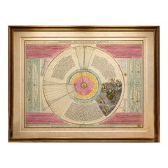
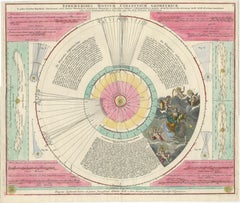
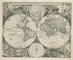
Copernican Solar System – Celestial Plan, Doppelmayer, Hand-Colored c.1742
Description:
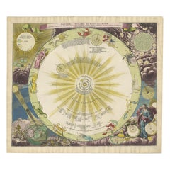
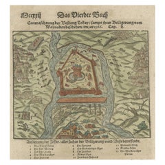
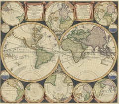
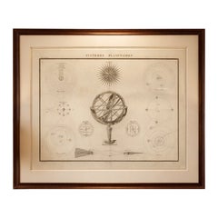
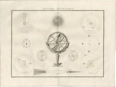
This large and finely engraved celestial chart illustrates the Copernican solar system and is titled Ephemerides Motuum Coelestium Geometrica, a scientific visualization of planetary motion according to the Copernican hypothesis. The work was created by Johann Gabriel Doppelmayer and published in Nuremberg circa 1742, during the height of the Enlightenment’s engagement with astronomy and mathematical science.
The map is offered unframed, giving flexibility to select a frame that best suits the intended interior.
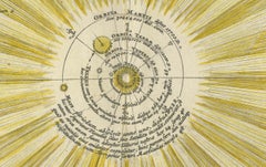
The chart presents a geometric representation of the irregular motions of the planets, including their directions, stations, and retrogradations. At the center is the sun, surrounded by concentric, color-coded orbital bands representing the paths of Mercury, Venus, Earth, Mars, Jupiter, and Saturn. Radiating lines and numerical annotations record observed planetary positions across specific dates, translating empirical observation into visual form.
Surrounding diagrams provide auxiliary explanations of orbital mechanics, apparent motion, and planetary phenomena. These panels were intended for scholarly use, offering astronomers, mathematicians, and educated readers a precise tool for understanding celestial movement within the Copernican framework. The Latin text reinforces its academic purpose and confirms its role as a serious scientific instrument rather than a decorative fantasy.
The composition is further enriched by allegorical figures representing astronomy and the celestial sciences, engraved in the Baroque tradition and delicately hand colored. These figures bridge science and art, a hallmark of Doppelmayer’s work, making the chart both intellectually rigorous and visually compelling.
Johann Gabriel Doppelmayer was one of the leading scientific illustrators and mathematicians of the Holy Roman Empire, closely associated with the Nuremberg publishing world. His celestial charts are today prized for their accuracy, clarity, and refined engraving quality.
This engraving stands as an important document in the history of astronomy, marking the widespread acceptance of the Copernican system in 18th-century Europe. It is highly desirable for collectors of scientific instruments, astronomical prints, Enlightenment-era works, and decorative interiors with intellectual character.
This chart was produced by Johann Gabriel Doppelmayer and published in Nuremberg circa 1742. Doppelmayer was a leading mathematician and scientific illustrator of the early Enlightenment, closely associated with the Nuremberg scientific publishing tradition. His Ephemerides Motuum Coelestium Geometrica played an important role in visualizing and popularizing the Copernican heliocentric system through precise geometric representation of planetary motion.
Condition report:
Good condition overall. Contemporary hand coloring. Light age toning and patina throughout, with minor browning and scattered surface marks consistent with age. Vertical centerfold as issued. Small handling wear at margins. No modern restoration observed.
Framing tips:
This chart benefits from a museum-style presentation. Use a wide ivory or warm off-white mat to balance the strong colors, paired with a dark walnut, ebonized, or gilt frame. UV-protective glazing is recommended due to the original hand coloring. Note: We supply this original antique map unframed.
Technique: Engraved map with contemporary hand coloring
Maker: Johann Gabriel Doppelmayer, Nuremberg, circa 1742
Keyword block:
celestial map, astronomical chart, Copernican system, solar system engraving, Johann Gabriel Doppelmayer, Doppelmayer celestial map, antique astronomy print, Enlightenment science, planetary orbits, ephemerides, retrograde motion, planetary motion diagram, heliocentric model, 18th century astronomy, scientific engraving, hand colored celestial map, Baroque astronomy, Nuremberg engraving, rare astronomy chart, historical science print, antique star chart...
Category
Mid-18th Century German Antique Maps