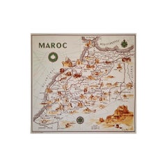
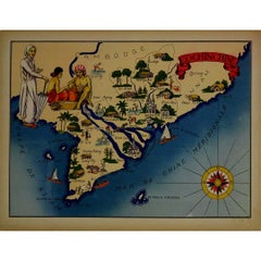
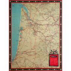
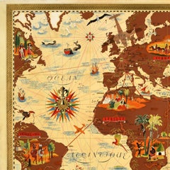
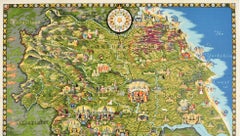
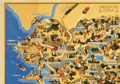
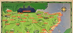
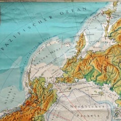
illustrated map of Morocco created in 1950 by Delaye
Located in PARIS, FR
Beautiful illustrated map of Morocco created in 1950 by Delaye.
Category
1950s Vintage Illustrated Maps
Materials
Paper, Lithograph
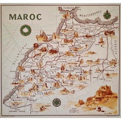
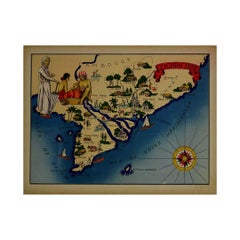
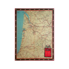
illustrated map of Morocco created in 1950 by Delaye
Located in PARIS, FR
Beautiful illustrated map of Morocco created in 1950 by Delaye.
Paper, Lithograph
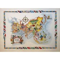
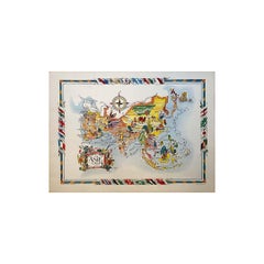
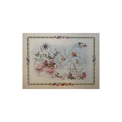
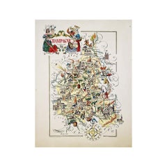
Jacques Liozu's 1951 illustrated map of Asia
By Jacques Liozu
Located in PARIS, FR
Jacques Liozu's 1951 illustrated map of Asia is an exceptional work of cartography that combines art and geography to offer a captivating vision of this vast continent.
Paper, Lithograph

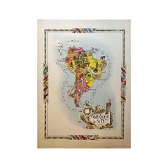
Jacques Liozu's 1951 illustrated map of South America
By Jacques Liozu
Located in PARIS, FR
Jacques Liozu's 1951 illustrated map of South America is an exceptional work of cartography that skilfully blends art and geography.
Paper, Lithograph
1943 original illustrated map of Cochinchine by Dylbert
Located in PARIS, FR
Dylbert’s map exemplifies mid-20th-century illustrated cartography, a style where maps were not only functional but also aesthetic.
Linen, Paper, Lithograph
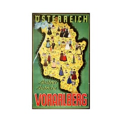
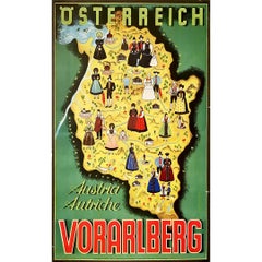
Original poster of Thurnher Weiss representing an illustrated map of Vorarlberg
Located in PARIS, FR
Original poster of Thurnher Weiss representing an illustrated map of Vorarlberg which is a region of Austria.
Paper, Lithograph
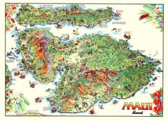
Maui, Hawaii — Kim Forrest, 1992 Illustrated Map Poster, Offset Lithograph
Located in Spokane, WA
Titled Maui, Hawaii, and created in 1992, this illustrated map by Kim Forrest presents the island through a lively, highly detailed visual language that merges cartography with story...
Offset

Circa 1950 original illustrated map "Carte des Montagnes Suisses"
Located in PARIS, FR
The circa 1950 original illustrated map "Carte des Montagnes Suisses" by L.
Linen, Paper, Lithograph
Circa 1950 original illustrated map for "Carte France autour de Bordeaux"
Located in PARIS, FR
Illustrated document Tourism - Bordeaux - Map
Linen, Paper
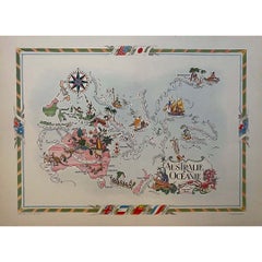
Jacques Liozu's 1951 illustrated map of Australia and Oceania
By Jacques Liozu
Located in PARIS, FR
Jacques Liozu's 1951 illustrated map of Australia and Oceania is a remarkable cartographic work that combines art and geography to offer an enchanting representation of this part of ...
Paper, Lithograph
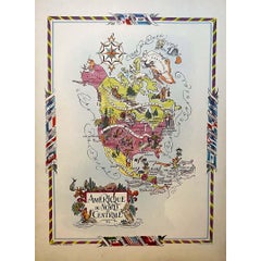
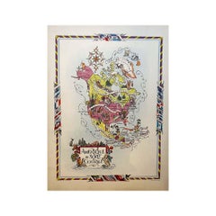
Jacques Liozu's 1951 illustrated map of North and Central America
By Jacques Liozu
Located in PARIS, FR
Jacques Liozu's 1951 illustrated map of North and Central America is an exceptional work of cartography that combines geographical precision with artistic aesthetics.
Paper, Lithograph
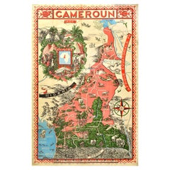

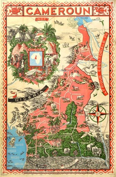
Original Vintage Illustrated Map Poster Afrique Equatoriale Francaise Cameroon
Located in London, GB
Original vintage illustrated map poster for Cameroun AOF Afrique Occidentale Francaise / Cameroon French West Africa showing the Central African country of Cameroon in pink and green...
Paper
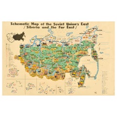

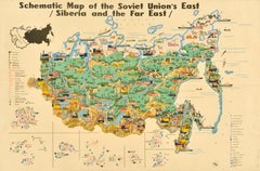
Original Vintage Illustrated Map Poster Schematic Map Soviet Union USSR Russia
Located in London, GB
Original vintage illustrated map poster - Schematic Map of the Soviet Union's East Siberia and the Far East - featuring forests, rivers, mountains, cattle and other animals, shipping...
Paper
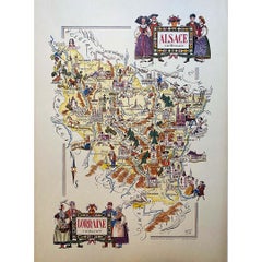
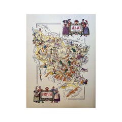
Jacques Liozu's 1951 illustrated map of Alsace and Lorraine in France
By Jacques Liozu
Located in PARIS, FR
Jacques Liozu's 1951 illustrated map of Alsace and Lorraine is a remarkable work of cartography that blends art and geography to offer a poetic and moving vision of these emblematic ...
Paper, Lithograph
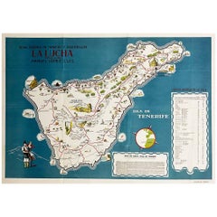
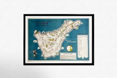
An original poster featuring an illustrated map of Tenerife - La Lucha
Located in PARIS, FR
A beautiful poster featuring an illustrated map of Tenerife or Tenerife, an island in Spain that forms part of the Canary Islands archipelago in the Atlantic Ocean.
Paper, Lithograph
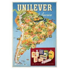

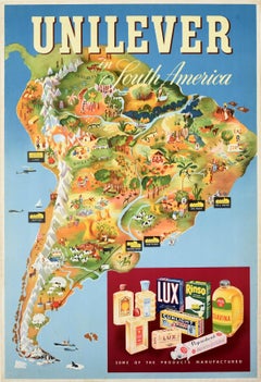
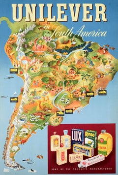
Original Vintage Advertising Poster Unilever South America Illustrated Map Art
Located in London, GB
Original vintage advertising poster for Unilever in South America featuring a colourful illustrated map marking the factories - Lever & Atkinson Lima Peru / Atkinson Santiago Chile /...
Paper
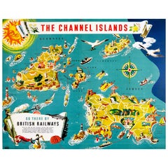
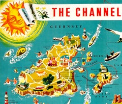
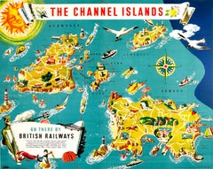
Original Vintage British Railways Poster Illustrated Map of the Channel Islands
Located in London, GB
Original vintage travel advertising poster for The Channel Islands - Go there by British Railways published by the Southern Region of British Railways. Colourful illustrated map of t...
Paper
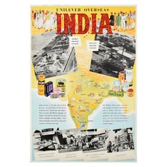
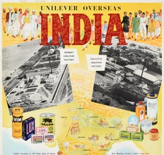
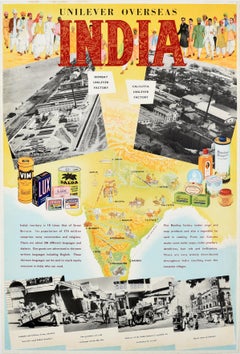
Original Vintage Advertising Poster Unilever Overseas India Illustrated Map
Located in London, GB
Original vintage advertising poster for Unilever Overseas India. Great illustrated map of India showing the industry production for Unilever with images including a tiger in a jungle...
Paper
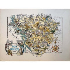
Jacques Liozu's 1951 illustrated map of the region of Pays d'Ouest
By Jacques Liozu
Located in PARIS, FR
Jacques Liozu's 1951 illustrated map of the Pays d'Ouest is a remarkable cartographic work that skilfully combines art and geography.
Paper, Lithograph
$637
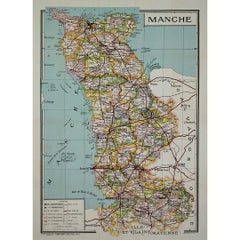
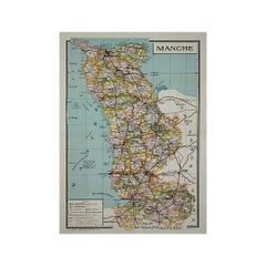
Circa 1950 original illustrated map by André Lesot for "Carte de la Manche"
Located in PARIS, FR
The circa 1950 original illustrated map by André Lesot for "Carte de la Manche" is a significant piece that highlights both artistic design and geographic representation.
Linen, Paper, Lithograph
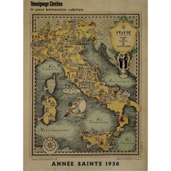
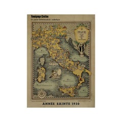
1950 illustrated map Italy, Land of Saints and Sanctuaries
Located in PARIS, FR
Churches, monasteries, and cathedrals populate the map, illustrating Italy’s deep religious heritage.
Linen, Paper, Lithograph
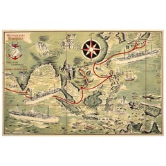
Original WWII Illustrated Map Poster - Time And Tide Map Of The Atlantic Charter
By "Leslie MacDonald ""Max"" Gill"
Located in London, GB
Original vintage illustrated map poster in Spanish by the notable graphic designer, cartographer and artist MacDonald Gill (Leslie MacDonald Gill aka Max Gill; 1884-1947) commissione...
Paper

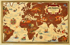
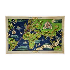
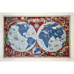
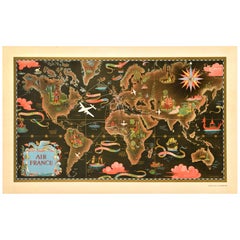
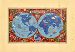
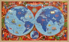
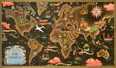
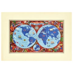
Original Vintage Travel Poster Air France Planisphere Illustrated Map Boucher
By Lucien Boucher
Located in London, GB
Original vintage travel poster advertising Air France featuring a stunning planisphere design by the French artist Lucien Boucher (1889-1971). Colourful depiction of the world featur...
Paper


Original Vintage Poster sle Of Skye Illustrated Map Scotland Macleod Macdonald
Located in London, GB
Original vintage pictorial map poster for the Isle of Skye featuring detailed fun and colourful illustrations with a railway and route map on the islands and places marked on scrolls...
Paper

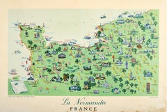
Original Vintage Travel Poster For La Normandie France Normandy Illustrated Map
Located in London, GB
Original vintage travel poster for Normandy - La Normandie France - featuring a pictorial map showing people, historical places of interest, hills and trees, horses, sailing boats an...
Paper
Original Vintage Advertising Poster Tahiti New Caledonia Illustrated Route Map
By Hervé Baille
Located in London, GB
Caledonien Tahitien. Fantastic illustrated map design by Herve Baille (1896-1974) depicting the ships sailing at sea with sailing boats, mythical nautical images, fish, an octopus an...
Paper
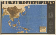
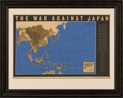
Original Vintage WWII Pacific Theater Map “The War Against Japan” Poster, 1944
Located in Langweer, NL
The map dramatically illustrates the enormous geographic scale of the Pacific Theater, extending from India and China across Southeast Asia and Japan to Hawaii and the wider Pacific ...
Paper
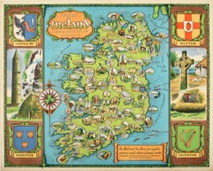
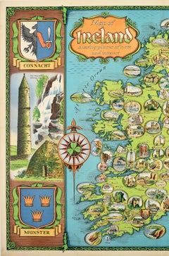
Circa 1960 Historical Map of Ireland by Leslie George Bullock
Located in PARIS, FR
Among his best-known works are illustrated maps of London, England, Wales, Ireland, and Scotland.
Paper
Circa 1960 Historical Map of Scotland by Leslie George Bullock
Located in PARIS, FR
Among his best-known works are illustrated maps of London, England, Wales, Ireland, and Scotland.
Paper
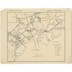
Antique Map of the Region of Utingeradeel by Meijer & Schaafsma, 1906
Located in Langweer, NL
This map illustrates part of Friesland (The Netherlands) depicting Akkrum, Terkaple, Lekkerterp, Oldeboorn and more.
Paper
$998
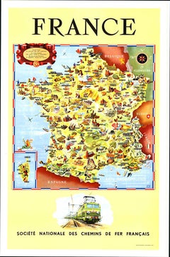
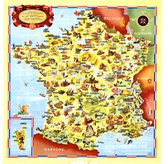
Original Societe Nationale des Chemin Map France, 1953 vintage poster on linen
Located in Spokane, WA
Original linen-backed poster; ready to frame. Artists include: illustrated map by Jean Cheval and Alex Batany (as Cheval-Batany) and electric train by P.
Lithograph
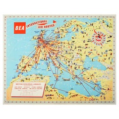

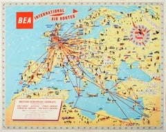
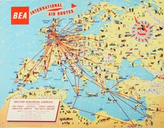
Original Vintage Poster BEA British European Airways International Air Route Map
Located in London, GB
Original vintage travel advertising poster for BEA British European Airways International Air Routes featuring an illustrated map showing the airline route lines and associated links...
Paper
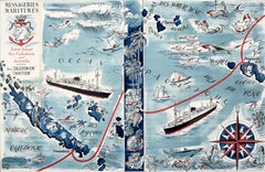
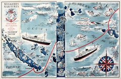
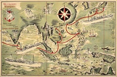
Original Vintage Advertising Poster Messageries Maritimes Far East Map H Baille
By Hervé Baille
Located in London, GB
Original vintage advertising poster for Messageries Maritimes Viet-Nam / Vietnam Cambodge / Cambodia Laos Courriers d'Extreme Orient / Far East featuring a fantastic illustrated map ...
Paper
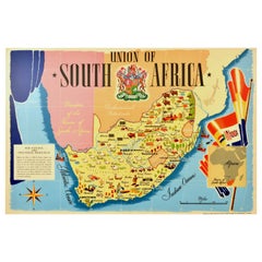

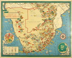
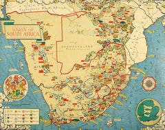
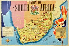
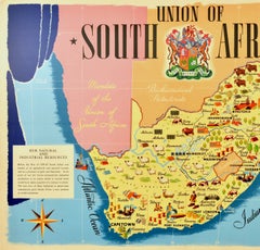
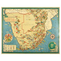
Original Vintage Poster Union Of South Africa Map Natural & Industrial Resources
Located in London, GB
Original vintage illustrated map poster for the Union of South Africa Her Natural and Industrial Resources featuring colourful images of the main cities including Cape Town, Pretoria...
Paper
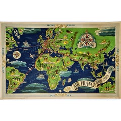
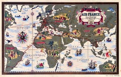
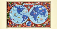
Original Vintage Travel Poster Air France Planisphere World Map Lucien Boucher
By Lucien Boucher
Located in London, GB
Original vintage poster issued by the French national airline carrier Air France featuring an illustrated map of the world by Lucien Boucher (1889-1971) with red route lines showing ...
Paper
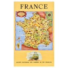
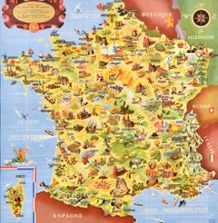
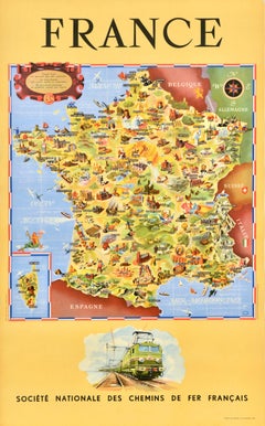
Original Vintage Rail Travel Map Poster France Map SNCF National French Railway
Located in London, GB
Original vintage rail travel map poster - France Societe Nationale des Chemins de Fer Francais - featuring a colourful illustrated map by Jean Cheval and Alex Batany (as Cheval-Batan...
Paper
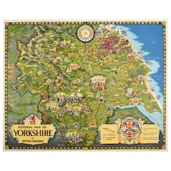
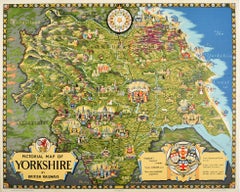
Original Vintage Poster Pictorial Map Of Yorkshire British Railways Train Travel
Located in London, GB
Original vintage train travel poster - Pictorial Map of Yorkshire by British Railways - featuring a colourful and detailed illustrated map of the historic county of Yorkshire in nort...
Paper
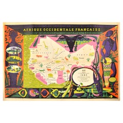
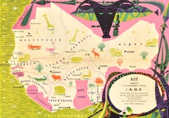
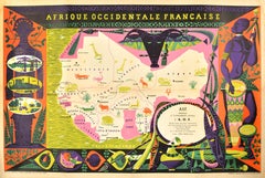
Original Vintage Poster French West Africa Map Afrique Occidentale Francaise Art
By alain cornic
Located in London, GB
Original vintage poster featuring an illustrated map of French West Africa / Afrique Occidentale Francaise marking the capital cities, towns, ports, Sahara Desert and rivers in Mauri...
Paper
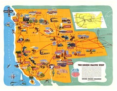
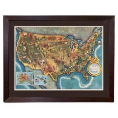
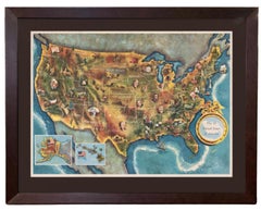
Union Pacific West vintage fun map railroad travel poster
Located in Spokane, WA
• Detailed Representation: Explore the charm of the Midwest with an intricately illustrated map that brings the region to life. From the plains of Kansas to the scenic beauty of Ca...
Offset
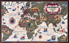
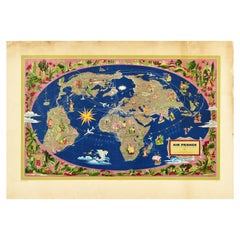
Original planisphere for Air France worldwide air network by Lucien Boucher
By Lucien Boucher
Located in PARIS, FR
He created a new genre by drawing illustrated maps of the world showing all the routes of the flights served by Air France.
Linen, Paper, Lithograph
$1,739
1953 Lucien Boucher Original poster for Air France - Planisphere - Aviation
By Lucien Boucher
Located in PARIS, FR
He created a new genre by drawing illustrated maps of the world showing all the routes of the flights served by Air France.
Linen, Paper, Lithograph
Original Vintage Travel Advertising Poster Air France Nova Et Vetera Boucher
By Lucien Boucher
Located in London, GB
Original vintage travel advertising poster - Air France Nova et Vetera Sur la Vieille Terre Des Chemins Nouveaux / New and Old On the Old Earth New Paths - featuring a colourful illu...
Paper
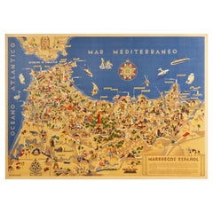
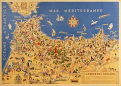
Original Vintage Map Poster Marruecos Espanol Spanish Morocco Illustrated Design
Located in London, GB
Original vintage travel map poster for Marruecos Espanol / Spanish Morocco featuring a great illustration of an outline of the Africa continent marking the major cities and locations...
Paper
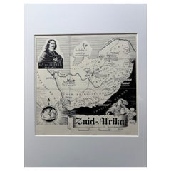
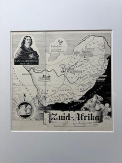
Original 1947 Map of South Africa by C. Burki – Jan van Riebeeck & Cape Colony
Located in Langweer, NL
The lower right bears Burki’s signature and the date “’47,” placing it among his early postwar works for Dutch publishers such as *Uitgeverij Succes* and *Shell Wereldkaarten*, which...
Paper
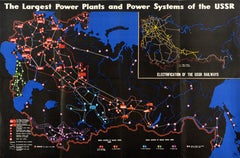
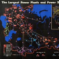
Original Vintage Information Poster Largest Power Plants USSR Soviet Union
Located in London, GB
Original vintage information poster - The Largest Power Plants and Power Systems of the USSR - featuring an illustrated map of the vast energy infrastructure of the Soviet Union show...
Paper
$1,043
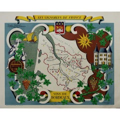
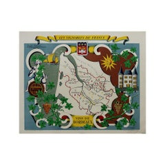
Stunning illustrated wine map by French artist Rémy Hétreau in the 1950s
By Rémy Hetreau
Located in PARIS, FR
This stunning illustrated wine map, created by French artist Rémy Hétreau in the 1950s, is a beautifully detailed tribute to the legendary Bordeaux wine region.
Paper, Lithograph
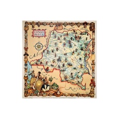
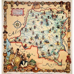
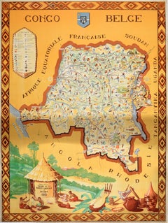
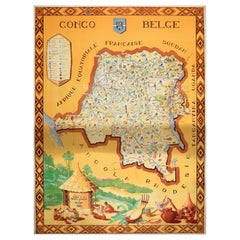
Original map of the Belgian Congo illustrated by James Thiriar in 1954
Located in PARIS, FR
Beautiful map of the Belgian Congo illustrated by James Thiriar in 1954.
Linen, Paper, Lithograph
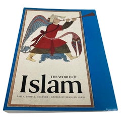
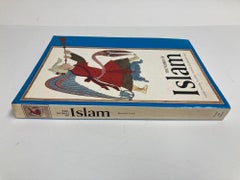
Islam: An Illustrated History by Bernard Lewis, UK Edition, 1992
Located in Moreno Valley, CA
Faith, people, culture. 490 illustrations, 160 in colour, 330 photographs drawings and maps. A concise, illustrated history of Islam which considers all aspects of its remarkably ric...
Paper
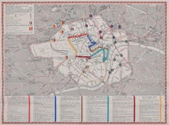
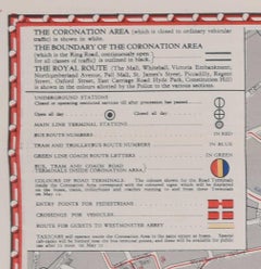
1953 Coronation Map for London Transport
Located in London, GB
Coronation Arrangements – Map of London (1953) Lithograph 45 x 60 cm (unfolded) Published by London Transport for the Coronation of Elizabeth II, this delightfully-coloured map illu...
Lithograph
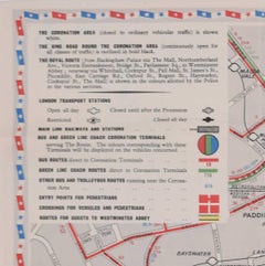
1937 Coronation Map for London Transport
Located in London, GB
Coronation Arrangements – Map of London (1937) Lithograph 45 x 60 cm (unfolded) Published by London Transport for the Coronation of George VI, this map illustrates the route the Kin...
Lithograph
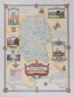
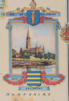
Wiltshire, original vintage map by Donald McCullough
Located in London, GB
David McCullough Wiltshire Lithograph 57 x 43 cm The Countryman County Map of Wiltshire was part of the Countryman magazine’s series of illustrated county maps, designed to celebr...
Lithograph
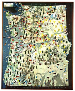
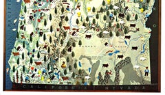
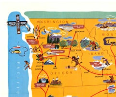
Original 1940 Washington & Oregon Pictorial Map vintage poster
Located in Spokane, WA
Explore the vibrant history and rich heritage of the Pacific Northwest with this beautifully illustrated vintage map of Washington and Oregon from 1940.
Offset
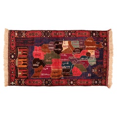
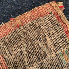
Vintage Beluch Tribal Rug depicting the Map of Afghanistan
Located in Milan, IT
A curious pictorial rug, woven by the Afghani Beluch people, illustrating a map of Afghanistan divided into regions at around the time of the Gulf war.
Wool


$1,159
Circa 1950 Desruol Messageries Maritimes Indian Ocean Line Map - Madagascar
Located in PARIS, FR
Rich in color, symbolism, and geographical interest, it remains a highly desirable piece for collectors of travel memorabilia, maritime history, and vintage French advertising. Illu...
Paper, Lithograph, Linen
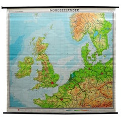
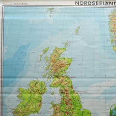
Great Britain Scandinavia Northern France Netherland Germany Mural Map
Located in Berghuelen, DE
The vintage pull-down cottagecore mural map illustrates the North Sea countries with Great Britain and Ireland, Scandinavia (Norway, Sweden, Denmark), Northern France, the Netherland...
Canvas, Wood, Paper

Original Vintage Travel Route Poster Air France Planisphere Map Lucien Boucher
By Lucien Boucher
Located in London, GB
Design by Lucien Boucher (1889-1971) featuring an illustrated planisphere map of the world with route lines and planes in white showing the airline's services to various internationa...
Paper
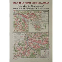
1944 original map Les vins de Champagne – Vignobles du Bar-Séquanais
By Louis Larmat
Located in PARIS, FR
Larmat’s attention to detail extends beyond just the geography. The map also provides a historical context for the Bar-Séquanais and Bar-sur-Aubois regions, illustrating their long-s...
Paper, Lithograph


1947 original map Gouvernement Généraux du Poitou, du Pays d'Aunis
By Louis Larmat
Located in PARIS, FR
Larmat’s cartographic works often transcended the realm of simple geographical depiction, becoming historical documents that encapsulate the cultural essence of the regions they port...
Paper, Lithograph
Unavailable
H 47.25 in W 30.71 in
Original Vintage Illustrated Map Poster Afrique Equatoriale Francaise Cameroon
Located in London, GB
Original vintage illustrated map poster for Cameroun AOF Afrique Occidentale Francaise / Cameroon French West Africa showing the Central African country of Cameroon in pink and green...
Paper
Unavailable
H 25.2 in W 38.19 in
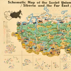
Original Vintage Illustrated Map Poster Schematic Map Soviet Union USSR Russia
Located in London, GB
Original vintage illustrated map poster - Schematic Map of the Soviet Union's East Siberia and the Far East - featuring forests, rivers, mountains, cattle and other animals, shipping...
Paper

Unavailable
H 44.1 in W 33.08 in
Original Vintage Africa Travel Poster Belgian Congo Congo Belge Illustrated Map
Located in London, GB
Design by Frans Laboulais (1903-1988) features an illustrated map depicting roads, railways, flight routes, national parks, Catholic churches, protestant churches, hydroelectric dams...
Paper
Unavailable
H 33.08 in W 42.52 in
Original Vintage Illustrated Map Poster Union Of South Africa MacDonald Gill
By "Leslie MacDonald ""Max"" Gill"
Located in London, GB
Original vintage illustrated map poster for the Union of South Africa - Philips pictorial map based upon original drawings by notable British graphic designer, cartographer, artist a...
Paper
Unavailable
H 29.93 in W 20.48 in
Original Vintage Advertising Poster Unilever South America Illustrated Map Art
Located in London, GB
Original vintage advertising poster for Unilever in South America featuring a colourful illustrated map marking the factories - Lever & Atkinson Lima Peru / Atkinson Santiago Chile /...
Paper

Unavailable
H 40.16 in W 50.01 in
Original Vintage British Railways Poster Illustrated Map Of The Channel Islands
Located in London, GB
Original vintage travel advertising poster for The Channel Islands - Go there by British Railways published by the Southern Region of British Railways. Colourful illustrated map of t...
Paper

Unavailable
H 29.53 in W 20.08 in
Original Vintage Advertising Poster Unilever Overseas India Illustrated Map
Located in London, GB
Original vintage advertising poster for Unilever Overseas India. Great illustrated map of India showing the industry production for Unilever with images including a tiger in a jungle...
Paper
Unavailable
H 44.89 in W 34.85 in
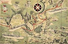
Original WWII Illustrated Map Poster - Time And Tide Map Of The Atlantic Charter
By "Leslie MacDonald ""Max"" Gill"
Located in London, GB
Original vintage illustrated map poster in Spanish by the notable graphic designer, cartographer and artist MacDonald Gill (Leslie MacDonald Gill aka Max Gill; 1884-1947) commissione...
Paper
Unavailable
H 20.08 in W 28.35 in
Original Vintage Travel Poster Air France Planisphere Illustrated Map Boucher
By Lucien Boucher
Located in London, GB
Original vintage travel poster advertising Air France featuring a stunning planisphere design by the French artist Lucien Boucher (1889-1971). Colourful depiction of the world featur...
Paper
Unavailable
H 24.02 in W 35.83 in
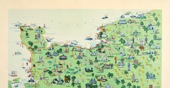
Original Vintage Travel Poster For La Normandie France Normandy Illustrated Map
Located in London, GB
Original vintage travel poster for Normandy - La Normandie France - featuring a pictorial map showing people, historical places of interest, hills and trees, horses, sailing boats an...
Paper

Unavailable
H 22.84 in W 35.04 in
Original Vintage Advertising Poster Tahiti New Caledonia Illustrated Route Map
By Hervé Baille
Located in London, GB
Caledonien Tahitien. Fantastic illustrated map design by Herve Baille (1896-1974) depicting the ships sailing at sea with sailing boats, mythical nautical images, fish, an octopus an...
Paper
Unavailable
H 35.04 in W 43.71 in
Original Vintage Poster BEA British European Airways International Air Route Map
Located in London, GB
Original vintage travel advertising poster for BEA British European Airways International Air Routes featuring an illustrated map showing the airline route lines and associated links...
Paper
Unavailable
H 40.16 in W 50.01 in
Original Vintage Travel Poster Map Of Ireland Showing Places Of Note & Interest
Located in London, GB
Colourful illustrated map of Ireland by David William Burley (1901-1990) including images of historic architecture such as bridges, castles and churches as well as people swimming, p...
Paper

Unavailable
H 22.84 in W 35.24 in
Original Vintage Advertising Poster Messageries Maritimes Far East Map H Baille
By Hervé Baille
Located in London, GB
Original vintage advertising poster for Messageries Maritimes Viet-Nam / Vietnam Cambodge / Cambodia Laos Courriers d'Extreme Orient / Far East featuring a fantastic illustrated map ...
Paper
Unavailable
H 19.69 in W 29.53 in
Original Vintage Poster Union Of South Africa Map Natural & Industrial Resources
Located in London, GB
Original vintage illustrated map poster for the Union of South Africa Her Natural and Industrial Resources featuring colourful images of the main cities including Cape Town, Pretoria...
Paper

Unavailable
H 39.38 in W 24.41 in
Original Vintage Rail Travel Map Poster France Map SNCF National French Railway
Located in London, GB
Original vintage rail travel map poster - France Societe Nationale des Chemins de Fer Francais - featuring a colourful illustrated map by Jean Cheval and Alex Batany (as Cheval-Batan...
Paper

Unavailable
H 40.16 in W 49.61 in
Original Vintage Poster Pictorial Map Of Yorkshire British Railways Train Travel
By E.H. Spencer
Located in London, GB
Original vintage train travel poster - Pictorial Map of Yorkshire by British Railways - featuring a colourful and detailed illustrated map of the historic county of Yorkshire in nort...
Paper

Unavailable
H 80 in W 120 in
Original Vintage Poster French West Africa Map Afrique Occidentale Francaise Art
By Alain Cornic 1
Located in London, GB
Original vintage poster featuring an illustrated map of French West Africa / Afrique Occidentale Francaise marking the capital cities, towns, ports, Sahara Desert and rivers in Mauri...
Paper

Unavailable
H 27.56 in W 38.39 in
Original Vintage Map Poster Marruecos Espanol Spanish Morocco Illustrated Design
Located in London, GB
Original vintage travel map poster for Marruecos Espanol / Spanish Morocco featuring a great illustration of an outline of the Africa continent marking the major cities and locations...
Paper
Agricultural Usa School Map, 1960s
Located in Dusseldorf, NRW
Wonderfully detailed school map, fondly illustrating the regional agriculture.

Unavailable
H 24.81 in W 38.98 in
Original Vintage Travel Route Poster Air France Planisphere Map Lucien Boucher
By Lucien Boucher
Located in London, GB
Design by Lucien Boucher (1889-1971) featuring an illustrated planisphere map of the world with route lines and planes in white showing the airline's services to various internationa...
Paper
Sold
H 22.05 in W 16.15 in
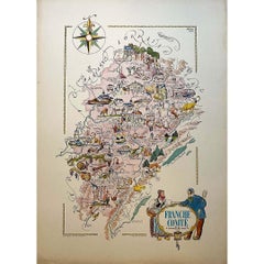
Jacques Liozu's 1951 illustrated map of the region of Franche-Comté
By Jacques Liozu
Located in PARIS, FR
Jacques Liozu's 1951 illustrated map of Franche-Comté is a cartographic work of great beauty and precision.
Paper, Lithograph

Sold
H 21.26 in W 16.15 in
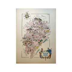
1951 oriignal illustrated map of Jacques Liozu for the Champagne region
By Jacques Liozu
Located in PARIS, FR
Beautiful illustrated map of Jacques Liozu for the Champagne region.
Linen, Paper, Lithograph

Sold
H 44.1 in W 33.08 in D 0.04 in
Original Vintage Africa Travel Poster Belgian Congo Congo Belge Illustrated Map
Located in London, GB
Design by Frans Laboulais (1903-1988) features an illustrated map depicting roads, railways, flight routes, national parks, Catholic churches, protestant churches, hydroelectric dams...
Paper

Sold
H 27.56 in W 39.38 in D 0.04 in
Original Vintage Travel Poster Cadiz Province Illustrated Map Art Deco Spain
Located in London, GB
Original vintage travel poster for the Provincia de Cadiz featuring an illustrated map marking the cities and other locations with a list of distinguished people and principal indust...
Paper

Sold
H 33.08 in W 42.52 in D 0.04 in
Original Vintage Illustrated Map Poster Union Of South Africa MacDonald Gill
By "Leslie MacDonald ""Max"" Gill"
Located in London, GB
Original vintage illustrated map poster for the Union of South Africa - Philips pictorial map based upon original drawings by notable British graphic designer, cartographer, artist a...
Paper
Sold
H 39.38 in W 24.61 in D 0.04 in
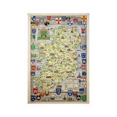
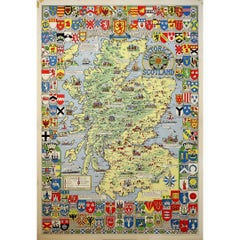
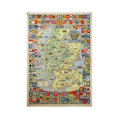
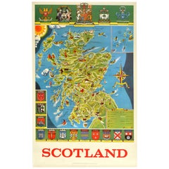
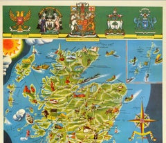
Original Vintage Poster Illustrated Map Of Scotland Sport Travel UK Coat Of Arms
Located in London, GB
Original vintage illustrated map poster for Scotland featuring a colourful design by Frederick Griffin (1906-1976) showing the coat of arms of each burgh / borough area around illust...
Paper
Sold
H 22.64 in W 31.5 in D 0.04 in
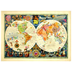
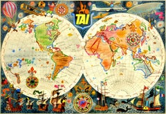
Original Vintage Airline Travel Poster TAI Planisphere Illustrated Map Aviation
Located in London, GB
Original vintage travel advertising poster for TAI Transports Aeriens Intercontinentaux Map of the World by Luc-Marie Bayle (1914-2000) featuring a colorful planisphere map showing t...
Paper
Sold
H 40.16 in W 50.4 in D 0.04 in
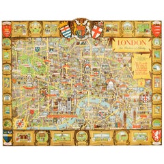
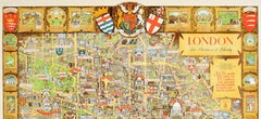
Original Vintage Poster London Bastion Of Liberty Illustrated Map WWII Churchill
By Kerry Lee
Located in London, GB
Original vintage travel map poster for London The Bastion of Liberty by the British artist, illustrator and poster designer Kerry Lee (1902-1988) to encourage tourism after World War...
Paper
Sold
H 20.08 in W 28.75 in D 0.04 in
Original Vintage Air France Poster Illustrated Map World Travel Art Planisphere
By Lucien Boucher
Located in London, GB
Original vintage travel poster advertising Air France featuring a stunning planisphere design by the French artist Lucien Boucher (1889-1971). Colourful depiction of the world featur...
Paper
Sold
H 33.86 in W 24.81 in
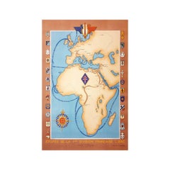
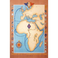
1945 illustrated map by Robert Louis - The epic of the 1st Free French Division
Located in PARIS, FR
Very nice map published by the Association of Free Frenchmen for the benefit of its Social Works and printed by Draeger in Paris This map illustrated by Robert Louis represents the ...
Paper, Lithograph
Sold
H 13.39 in W 16.34 in D 1.58 in
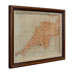
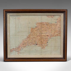
Vintage Framed Map, English, Mahogany, Illustrated, Devon, Cornwall
Located in Hele, Devon, GB
This is a vintage framed map. An English, mahogany illustrated map of Devon and Cornwall, dating to the mid-20th century.
Paper
Sold
H 20.38 in W 27.25 in D 2.25 in
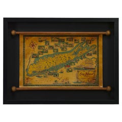
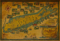
1964 Pictorial Map of Long Island by Catherine & E. Theodore Nelson
Located in Colorado Springs, CO
Presented is a colorful and whimsical pictorial map of Long Island. The map was illustrated and published by creative husband and wife duo Catherine Nelson and E.
Paper
Sold
H 22.5 in W 29 in D 0.75 in
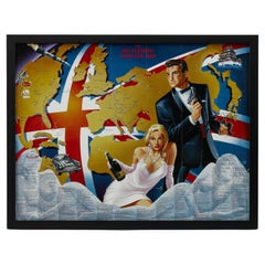
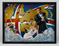
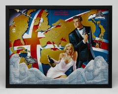
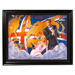
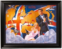
1987 "the Ian Fleming Thriller Map" by Aaron Silverman and Molly Maguire
Located in Colorado Springs, CO
The pictorial map was illustrated by John Zeleneck, with graphics by Susan Lewis.
Paper
Sold
H 22.5 in W 29 in D 0.75 in
1987 "the Ian Fleming Thriller Map" by Aaron Silverman and Molly Maguire
Located in Colorado Springs, CO
The pictorial map was illustrated by John Zeleneck, with graphics by Susan Lewis.
Paper
Sold
H 25.25 in W 31.75 in D 1.13 in
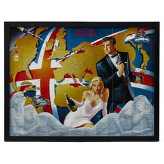
1987 "The Ian Fleming Thriller Map" by Aaron Silverman and Molly Maguire
Located in Colorado Springs, CO
The pictorial map was illustrated by John Zeleneck, with graphics by Susan Lewis.
Paper

Sold
H 29.93 in W 43.31 in D 0.04 in
Original Vintage Air France Travel Advertising Poster Airline Lucien Boucher Map
By Lucien Boucher
Located in London, GB
Original vintage Air France travel advertising poster featuring an illustrated map of the world by Lucien Boucher (1889-1971) depicting planes flying around the globe showing the air...
Paper
Sold
H 40.16 in W 50.01 in D 0.04 in
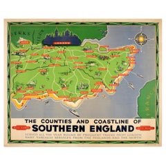
Original Vintage British Railways Poster Map Counties Coastline Southern England
Located in London, GB
Original vintage travel poster for The Counties and Coastline of Southern England issued by British Railways – Served all the year round by frequent trains from London many through s...
Paper
![[World War Two map] - Dunkirk to Berlin June 1940.](https://a.1stdibscdn.com/a_14192/a_122803621683893882824/108529_master.jpg?width=240)
![[World War Two map] - Dunkirk to Berlin June 1940.](https://a.1stdibscdn.com/a_14192/a_122803621683893894874/108529_2_master.jpg?width=240)
[World War Two map] - Dunkirk to Berlin June 1940.
Located in London, London
In addition, the map also illustrates Churchill's 1944 tours of the beaches of Normandy and the invasion coasts of Italy and Southern France.
Color
Sold
H 25 in W 1.13 in D 31.75 in
1960 "The 50 United States of America" Pictorial Map by Lorin Thompson
Located in Colorado Springs, CO
The map is illustrated with past presidents, Native Americans, depictions of the "Golden Spike" in Utah, gold mining in California, Kitty Hawk, and more.
Paper
Sold
H 47.25 in W 67.33 in D 0.79 in
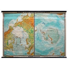
Vintage Map North Pole South Pole Polar Region Rollable Wall Chart
Located in Berghuelen, DE
A classical pull-down wall chart map illustrating the North and South polar region, published by Wenschow relief maps.
Canvas, Wood, Paper
Sold
H 22.45 in W 32.68 in D 0.04 in
Original Vintage Advertising Poster Inn-Signia Of Whitbread Houses In East Kent
Located in London, GB
Original vintage advertising poster designed as an illustrated travel map of Kent in the south east of England: Inn-Signia Of Whitbread Houses In East Kent, the map devised and drawn...
Paper

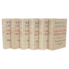
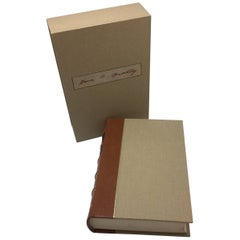
Churchill, Winston, the World Crisis, '6 Volumes, Easton Press, 1991'
Located in Hillsborough, NJ
., 9-3/8" x 6-3/8", illustrated with maps (some fold-out) and charts, bound in full red leather, gilt stamped covers and spine, all edges gilt, silk morie pastedowns and endpapers.
Leather

Sold
H 9.5 in W 6.5 in D 1 in
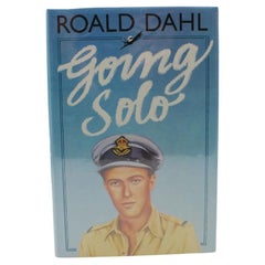
Going Solo, Signed by Roald Dahl, First Edition in Original Dust Jacket, 1986
By Roald Dahl
Located in Colorado Springs, CO
In the publisher's original hardcover navy cloth boards with gilt titles to the spine and original illustrated dust jacket. Illustrated with maps and numerous black and white illustr...
Paper


Sold
H 8.5 in W 5.88 in D 1.75 in
A Soldier's Story, Signed by Omar Bradley, First Edition in Dust Jacket, 1951
Located in Colorado Springs, CO
Signed and inscribed on the full title page in blue ink "For Philip Corrin, With best wishes. Omar N Bradley." Illustrated throughout with photographs and maps. 618 pp.
Paper

Sold
H 8.5 in W 6 in D 2 in
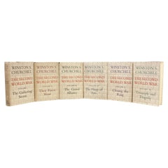
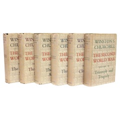
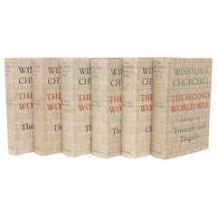
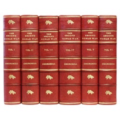
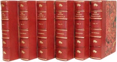
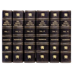
Churchill, the Second World War, All First Editions, 6 Volumes, with the Dj's
Located in Hillsborough, NJ
DESCRIPTION: ALL FIRST EDITIONS. 6 volumes, illustrated, fold-out maps, original publisher's gilt lettered black cloth, internally clean and bright, bindings in VERY GOOD condition, ...
Fabric

Sold
H 8 in W 6 in D 2 in
CHURCHILL. The Second World War. ALL FIRST EDITIONS - 6 VOLUMES - WITH THE DJ's
Located in Hillsborough, NJ
DESCRIPTION: ALL FIRST EDITIONS. 6 volumes, illustrated, fold-out maps, original publisher's gilt lettered black cloth, internally clean and bright, bindings in VERY GOOD condition, ...
Fabric

Sold
H 8.5 in W 5.88 in D 2 in
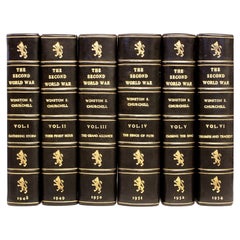
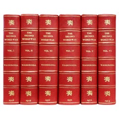
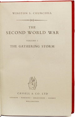
CHURCHILL, The Second World War, All First Editions 6 Vols. in a Leather Binding
Located in Hillsborough, NJ
Description: All first editions. 6 volumes, 8-1/2" x 5-7/8", illustrated, fold-out maps, bound in 1/2 black morocco, ribbed gilt decorated spines, top edges gilt.
Leather
Sold
H 9 in W 6 in D 1 in
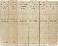
CHURCHILL The Second World War - 6 VOLS - ALL FIRST EDITIONS - WITH DUST JACKETS
Located in Hillsborough, NJ
DESCRIPTION: ALL FIRST EDITIONS. 6 volumes, illustrated, fold-out maps, original publisher's gilt lettered black cloth.
Fabric
Sold
H 8.5 in W 5.88 in D 2 in
Churchill, the Second World War. All First Editions, Leather Bound, 6 Volumes
Located in Hillsborough, NJ
DESCRIPTION: ALL FIRST EDITIONS. 6 volumes, 8-1/2" x 5-7/8", illustrated, fold-out maps, bound in 1/2 bred morocco, ribbed gilt decorated spines, top edges gilt.
Leather
Sold
H 8.5 in W 5.88 in D 2 in
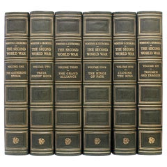
Winston CHURCHILL. The Second World War - ALL FIRST EDITIONS - 1948 - 54
Located in Hillsborough, NJ
DESCRIPTION: ALL FIRST EDITIONS. 6 volumes, 8-9/16" x 6-1/6", illustrated, fold-out maps, bound in 1/2 red morocco, ribbed gilt decorated spines, by Atkinson.
Leather

Sold
H 8.5 in W 5.88 in D 2 in
Churchill, the Second World War. All First Editions in Full Leather Bindings
Located in Hillsborough, NJ
DESCRIPTION: ALL FIRST EDITIONS. 6 volumes, 8-1/2" x 5-7/8", illustrated, fold-out maps, bound in full blue morocco, ribbed gilt decorated spines, covers ruled in gilt, gilt dentelle...
Leather

Sold
H 9 in W 6 in D 1 in
CHURCHILL The Second World War - 6 VOLS - ALL FIRST EDITIONS - WITH DUST JACKETS
Located in Hillsborough, NJ
DESCRIPTION: ALL FIRST EDITIONS. 6 volumes, illustrated, fold-out maps, original publisher's gilt lettered black cloth.
Fabric

Soldier's Story by Omar Bradley, Signed First Edition, circa 1951
Located in Colorado Springs, CO
Inscribed and signed first trade edition by the author -- General Omar Bradley. Illustrated throughout with 55 maps and 17 black-and-white illustrations, including photographs.

Sold
H 8.5 in W 5.88 in D 2 in
Winston CHURCHILL. Second World War - 6 vols. - ALL FIRST EDITIONS 1948 - 54
Located in Hillsborough, NJ
DESCRIPTION: ALL FIRST EDITIONS. 6 volumes, 8-1/2" x 5-7/8", illustrated, fold-out maps, bound in full dark blue morocco, ribbed gilt decorated spines, covers ruled in gilt, marbled ...
Leather
Sold
H 8.5 in W 5.88 in D 2 in
CHURCHILL, The Second World War, All First Editions, 6 Volumes, Leather Bound
Located in Hillsborough, NJ
Description: All first editions. 6 volumes, 8-1/2" x 5-7/8", illustrated, fold-out maps, bound in 1/2 bred morocco, ribbed gilt decorated spines, gilt lettered green morocco spine la...
Leather

Sold
H 9.88 in W 7.13 in D 1 in
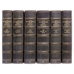
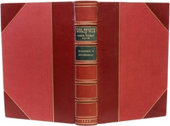
Winston CHURCHILL - The Second World War - 6 VOLS - THE CHARTWELL EDITION - 1954
Located in Hillsborough, NJ
DESCRIPTION: THE CHARTWELL EDITION. 6 volumes, 9-7/8" X 7-1/8", illustrated, fold-out maps, bound in the deluxe binding of 1/4 blue morocco, spines tooled in gilt and blind.
Leather