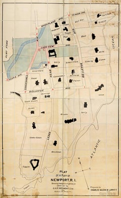
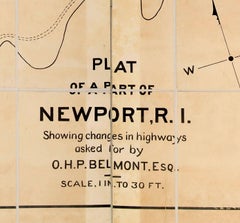
Plan of a Part of Newport, R. I. Showing Changes... O. H. P, Belmont, Esq.
PLAN OF A PART OF NEWPORT, R.I. SHOWING CHANGES IN HIGHWAYS ASKED FOR BY O.H.P. BELMONT, ESQ.
The original ink and watercolor plan on paper from 1907. The plan is extremely large; if fully assembled it would measure no less than 11.5 feet in height and 6.5 feet in breadth. Segmented and backed on modern linen in four sections – each section is 70 x 39 inches. This grand oversized folding map can be folded down to four sections each 17.5 x 11 inches and stored in a modern made leather and marble paper case 18 x 11.75 x 3 inches.
Text continues, "Prepared for Charles Warren Lippitt at the office of J. P. Cotton, C.E. Newport, R.I. Oct. 28, 1907." A fine manuscript plan of the Bellevue neighborhood of Newport, depicting the street layout and the detailed footprints of the area’s many mansions.
The plan was produced at the behest of Charles Warren Lippett (1846-1924), who served as governor of Rhode Island from 1895-1897. The Lippett “Breakwater” mansion is also shown on this plan, situated at the southernmost tip of the peninsula. Though the circumstances are unclear, Lippitt seems to have requested the plan be drawn out of some concern for road construction proposed by Oliver Hazard Perry...
Category
Early 20th Century Naturalistic Johann Wilhelm Weinmann More Art