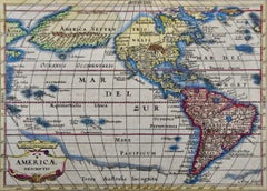
North & South America: A 17th Century Hand-colored Map by Jansson & Goos
$1,275
H 7 in W 8.63 in D 0.07 in
North & South America: A 17th Century Hand-colored Map by Jansson & Goos
By Johannes Janssonius
Located in Alamo, CA
A 17th century hand-colored map of North & South America entitled "Americae Descriptio" by the cartographer Johannes Jansson, published in Jansson's Atlas Minor in Amsterdam in 1628....
Category
1620s Dutch Antique Johannes Janssonius
Materials
Paper