By George Nakashima
Located in New York, NY
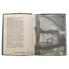
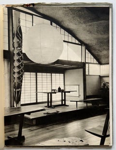
The catalog comprises: First, an introductory paean to craftsmanship and the spirituality of woodworking culminating in Nakashima’s bold signature in ink, dated April 1962. Next, a full-page photo of the Conoid Studio followed by a succession of offerings with photos and descriptions including: Trestle Table, Cross-Legged Table, Round Turned-Leg table, Conoid Table, Turned-Leg Table, Round Clustered-Base Table, Round Pedestal Table, Frenchman’s Cove Square Table, Single Drop-Leaf Table, Boat-Shaped Table, Frenchman’s Cove No.2 Table (fold-out), Round Coffee Table, Conoid Coffee Table, Slab Coffee Table No. 2, Slab Coffee Table, Portsmouth End Table, Square or Rectangular End Table (with and without shelf), Cross-Legged Coffee Table, Conoid Studio End Tables, Conoid Desks, New Chairs, Mira Chairs, Lounge Chair, No Arm, Lounge Chair One-Arm, Grass-Seated Chair, Arm Chair, conoid Chair, New Chair plus Rockers and Arms, Lounge Chair plus Rockers and Arms, Conoid Benches, “Q” Bench, “R” Bench...
Category
1960s American American Craftsman Vintage Paper Furniture