Copper Drawings
to
1
1
Height
to
Width
to
1
9,594
1,734
456
224
109
1
1
1
1
1
1
1
Material: Copper
Framed 17th Century Map of Cumberland, England by John Speed, 1610
By John Speed
Located in Middleburg, VA
A fascinating and richly detailed antique map of Cumberland County in northwest England, drawn and published by the celebrated English cartographer John Spe...
Category
Early 17th Century English British Colonial Antique Copper Drawings
Materials
Copper, Gold Leaf
Related Items
Large 17th Century Hand Colored Map of England and the British Isles by de Wit
Located in Alamo, CA
A large hand colored 17th century map of England and the British Isles by Frederick de Wit entitled "Accuratissima Angliæ Regni et Walliæ Principatus", published in Amsterdam in 1680. It is a highly detailed map of England, Scotland, the Scottish Isles...
Category
Late 17th Century Dutch Antique Copper Drawings
Materials
Paper
$1,175
H 35 in W 30.5 in D 2 in
Ciro Ferri Drawing Offering Scene Italie 17th Century
Located in Beuzevillette, FR
Italian lead pencil drawing, entourage of Ciro Ferri, depicting an offering scene in front of a temple, in the manner of the antiquity.
Measurements: 7.8/5.9 inches
...
Category
17th Century Italian Antique Copper Drawings
Materials
Paper
Early 19th Century Original Framed Land Indenture, England, 1810
Located in Lambertville, NJ
A large hand written land indenture document England, 1810, framed. The beautifully hand written document mounted on board with a red velvet border and ...
Category
1810s English Regency Antique Copper Drawings
Materials
Glass, Giltwood, Parchment Paper
17th Century Map of Denmark by French Cartographer Sanson, Dated 1658
Located in Copenhagen, K
17th century map of Denmark by French cartographer Sanson.
Nicolas Sanson (20 December 1600-7 July 1667) was a French cartographer, termed by some the creator of French geography an...
Category
17th Century French Antique Copper Drawings
Materials
Paper
$1,750
H 18.51 in W 23.23 in D 0.4 in
17th-Century Map of the Latin Patriarchate of Jerusalem by Melchior Tavernier
Located in Langweer, NL
Title: 17th-Century Map of the Latin Patriarchate of Jerusalem by Melchior Tavernier
Description: This rare 17th-century map by Melchior Tavernier illustrates the geographical ext...
Category
1640s Antique Copper Drawings
Materials
Paper
$855
H 17.33 in W 22.84 in D 0.01 in
Table Low Sofa Vintage 1950s Map Isle of Man John Speed 1610 Thomas Durham 1595
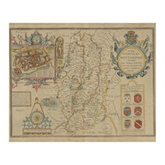
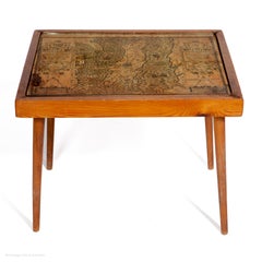
Located in BUNGAY, SUFFOLK
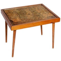
- The juxtaposition of modern design and this ancient map create a unique small table and conversation piece
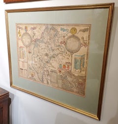
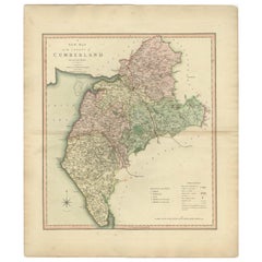
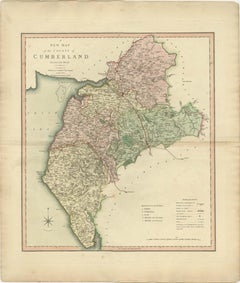
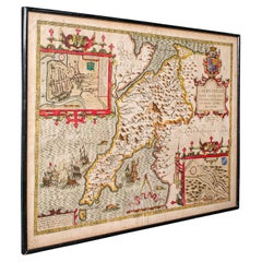
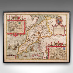
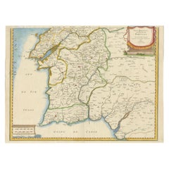
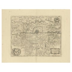
- This is the first map featuring the Isle of Man on its own.
- It is also the first map of the Island based on an actual survey, undertaken by Thomas Durham 1595 and was first published by Speed in 1605-1611 and reprinted many times over the next century. This is the second state or print from 1610.
The map is inset within a fruitwood box frame with a glass top. Supported by tapering stick legs.
The map is based on a survey (and presumably a MS map) by Thomas Durham, of whom nothing is known other that he was paid by Sir Thomas Gerrard to make a survey of the Island. This survey, almost certainly for military purposes, arose from the disputed possession of the Island during which time Elizabeth had assumed control in order to prevent the Scots or the Spanish from using the Island as a base.
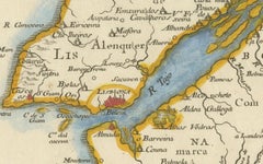
Speed had used the Durham Map in his slightly earlier 4-sheet wall map showing invasions and battles of c1603/4 [ref: Shirley #261] - there are some differences from this 1605/10 map - Port Eran (rather than Earn on 1605);Knockalo point (= Contrary Hd) not on 1605;Spalbrecke shown west of Calf rather than E as on 1605/10. Thus it is possible that the Durham Map had even more detail than Speed used in his derived version.
In sea are four mythical beasts with riders: to NW of Island Unicorn with Scottish flag...
Category
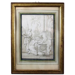
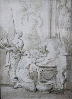
1610s English Mid-Century Modern Antique Copper Drawings
Materials
Paper
$3,426
H 16.54 in W 20.24 in D 16.54 in
Willem Janszoon Blaeu Rare Original 17th Century Map of Ethiopia in a Pine Frame
By Willem Blaeu
Located in Meer, VAN
Willem Janszoon Blaeu Rare Original 17th Century Map of Ethiopia in a Pine Frame
Rare early 17th century map of Ethiopia by Willem Janszoon Blaeu. The Netherlands.
A so called ‘'A...
Category
17th Century Antique Copper Drawings
Materials
Pine, Paper
$3,506
H 21.26 in W 22.84 in D 1.19 in
Antique Map of Warwickshire in England by Speed, c.1614
Located in Langweer, NL
Antique map titled 'The Counti of Warwick the Shire Towne and Citie of Coventre described'. Map of Warwickshire, England. Includes inset town plans of Warwic...
Category
17th Century Antique Copper Drawings
Materials
Paper
$722 Sale Price
20% Off
H 16.54 in W 21.46 in D 0 in
Antique Framed Pen and Ink on Fabric Map of Cornwall from Early 19th Century
Located in Los Angeles, CA
This English fabric map of Cornwall, rendered in pen-and-ink, showcases exquisite hand-drawn details and charming faded sepia tones. Encased in a classic frame, this piece elegantly ...
Category
Early 19th Century English Antique Copper Drawings
Materials
Walnut, Fabric
$2,475
H 30.5 in W 44.5 in D 1 in
17th Century Nicolas Visscher Map of Southeastern Europe
Located in Hamilton, Ontario
A beautiful, highly detailed map of southeastern Europe by Nicolas Visscher. Includes regions of Northern Italy (showing the cities Bologna, Padua, and Venice), Bohemia, Austria (sho...
Category
17th Century Dutch Antique Copper Drawings
Materials
Paper
$1,350 Sale Price
38% Off
H 26.5 in W 40.75 in D 1 in
17th Century Framed Map of Ancient France Titled "Typus Galliae Veteris"
Located in Dallas, TX
Decorate an office or a library with this elegant historic map. Crafted in the Netherlands circa 1630, this beautifully framed antique map with pr...
Category
17th Century Dutch Baroque Antique Copper Drawings
Materials
Glass, Giltwood, Paper
$2,800
H 27 in W 30.5 in D 2.25 in
OriginaAntique 17th-Century Map of Guizhou Province, China – (Qveichev) by Blaeu
Located in Langweer, NL
Title: Antique 17th-Century Map of Guizhou Province, China – "Qveichev" by Blaeu, Richly Illustrated and Colored
Description: This remarkable map of Guizhou Province, historically known as "Qveichev," was created by Johannes Blaeu and published in 1655 as part of his *Novus Atlas Sinensis*. This atlas, developed in collaboration with Jesuit missionary Martino Martini, marked the first Western attempt at a comprehensive geographic representation of China. Blaeu’s map offers a detailed depiction of the mountainous terrain, rivers, and towns of Guizhou, a province known for its rugged beauty and cultural diversity.
The map is adorned with two decorative cartouches, each reflecting the artistic and cultural influences of the time. The title cartouche in the lower-right corner features two figures in traditional Chinese attire, symbolizing the blend of European cartographic mastery and Chinese heritage. The upper-left corner includes a secondary cartouche with an explanatory key, adding a touch of elegance to the map’s functionality. Towns, mountains, and rivers are meticulously labeled in Latin, showcasing Blaeu’s dedication to detail and accuracy.
Crafted using the copperplate engraving technique, this map demonstrates exceptional precision. The hand-coloring enhances its visual appeal, highlighting borders and geographic features with vibrant tones. Blaeu’s work is not only a tool for geographic understanding but also a piece of art that embodies the spirit of exploration during the Dutch Golden Age.
Guizhou Province, historically known as "Qveichev," is renowned for its breathtaking natural landscapes, rich ethnic diversity, and historical significance. As one of China's most mountainous regions, Guizhou is characterized by dramatic karst formations, lush green hills, and cascading waterfalls. The province is also home to a variety of ethnic minority groups, including the Miao, Dong, and Bouyei, whose traditions, colorful costumes, and vibrant festivals make the region culturally significant.
Famous features and important places include Huangguoshu Waterfall, one of Asia's largest and most iconic waterfalls, located near the city of Anshun. Zhijin Cave, a vast karst cave system, is celebrated for its stunning stalactites and stalagmites. Kaili is known as the cultural center of Miao traditions, with picturesque villages and celebrated festivals. Zunyi holds historical importance for the Zunyi Conference, a pivotal event in the Chinese Communist Party's history. Fanjing Mountain, a UNESCO World Heritage Site, stands out for its unique biodiversity and sacred Buddhist sites.
Keywords: antique map of China, Guizhou map, Qveichev, 17th-century China map...
Category
1650s Antique Copper Drawings
Materials
Paper
$1,664
H 18.9 in W 23.04 in D 0.01 in
Previously Available Items
Set of Three Zoological Copper Etchings Depicting Anatomy of Fish, 18th Century
Located in Savannah, GA
Set of three zoological copper etching plates depicting fish, hand colored, circa 1781-1795. Title: “Cyprinus Gibelio,” “Chaetadon Kleinii & Chaetadon Chinensis” and “Holocentrus Arg...
Category
18th Century English Antique Copper Drawings
Materials
Copper
H 18 in W 23.5 in D 1 in
Equitation Set of 4 Gravures by the Famous House of Diderot et d' Alembert
Located in Ballard, CA
This set of the Manège et Equitation is in great condition, This fine copperplate engraving of the Manege et Equitation from Diderot et d'Alembert features the "Ballotade" and is mar...
Category
Late 18th Century French Antique Copper Drawings
Materials
Copper
H 12.25 in W 13.75 in D 0.5 in
19th Century Oil on Copper Italian Antique Religious Painting Virgin with Child
Located in Vicoforte, Piedmont
Antique Italian painting from the 19th century. Oil on copper framework depicting Virgin with child of good pictorial quality. Small framework, for antique dealers and collectors of ...
Category
Late 19th Century Italian Antique Copper Drawings
Materials
Copper
H 12.6 in W 10.63 in D 1.19 in
Copperplate Engraving "Fisherman In Their Return" Jakob Hägg by Norilling, 1971
Located in Sofia, BG
Jakob Hägg was Swedish artist who was born in 1839. Jacob Hägg's work has been offered at auction multiple times, with realized prices ranging from $1,157 USD to $246,803 USD, depend...
Category
1970s Swedish Arts and Crafts Vintage Copper Drawings
Materials
Copper
H 18.12 in W 25.99 in D 1.19 in
Three Zoological Copper Etching Plates Depicting Anatomy of Fish, 18th Century
Located in Savannah, GA
Set of three zoological copper etching plates depicting fish, hand colored, circa 1781-1795. Title: “Cyprinus Gibelio,” “Chaetadon Kleinii & Chaet...
Category
18th Century English Antique Copper Drawings
Materials
Copper
H 18 in W 23.5 in D 1 in


