
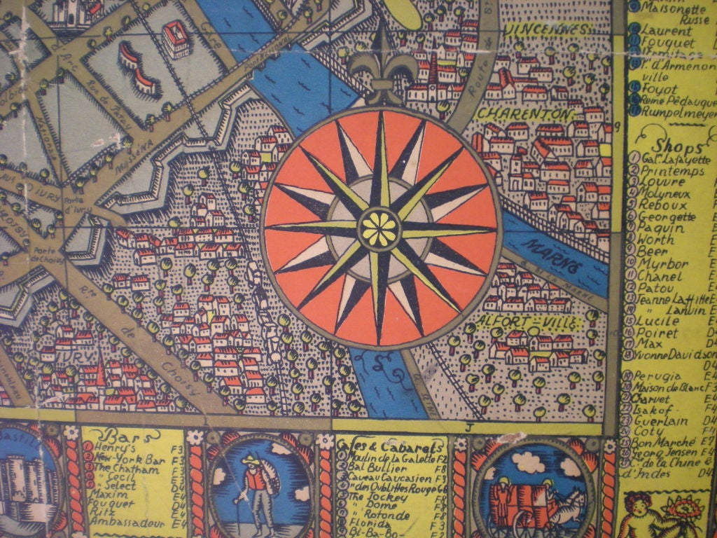
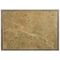
Vintage 1927 Paris Map Created by Ilonka Karasz
Located in Dallas, TX
Stylish paper map of Paris mounted on board in colors of red/blue/yellow.
Category
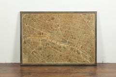
Vintage 1927 Paris Map Created by Ilonka Karasz
Located in Dallas, TX
Stylish paper map of Paris mounted on board in colors of red/blue/yellow.
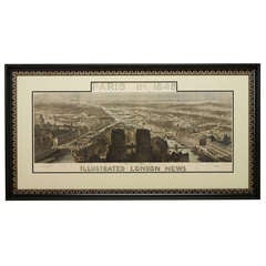
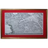
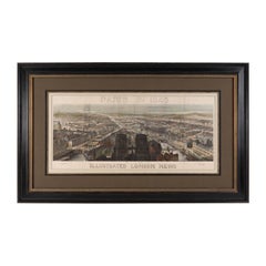
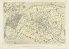
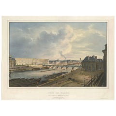
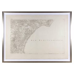
1848 Panorama Hand-Colored Map of Paris Showing Notre Dame Cathedral
Located in Colorado Springs, CO
This 1848 panorama map of Paris was published by the Illustrated London News as an insert in its publication – this being part of a series on maps featuring the great cities of the W...
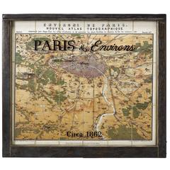
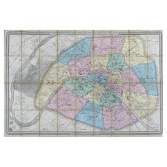
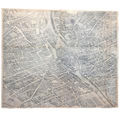
1862 Guittet View and Map of Paris in Antique Windowpane Frame
Located in Colorado Springs, CO
This is a striking and colorful 1862 chromolithograph birds-eye map of Paris, France, and vicinity by Guittet. Centered on the Paris and the Seine River, this map covers from Triel t...
Sold|$5,595
World Map of 19th Century
Located in Saint-Ouen, FR
World map signed Maison Delamarche Paris. 19th century.
Wood
Sold|$9,800
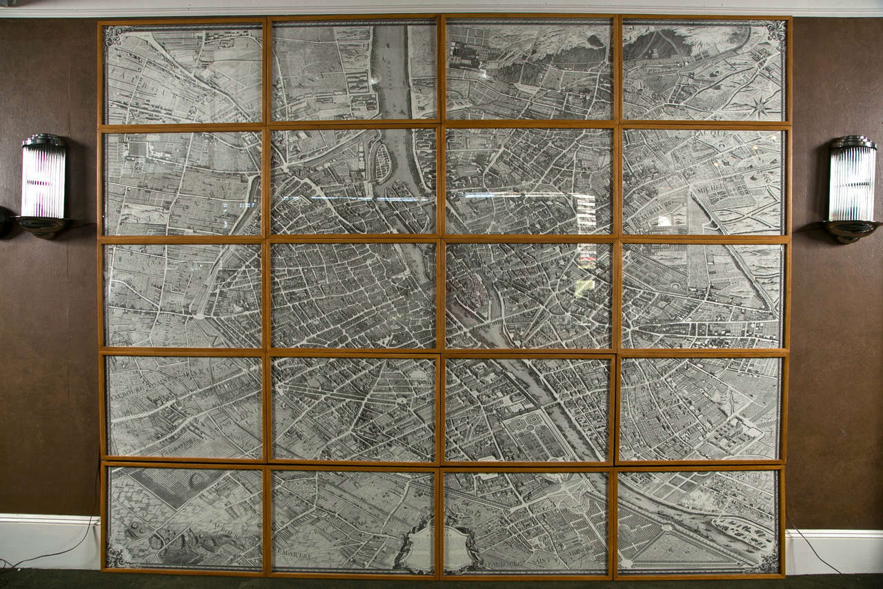
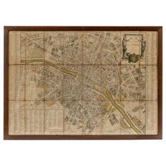
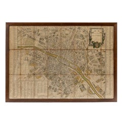
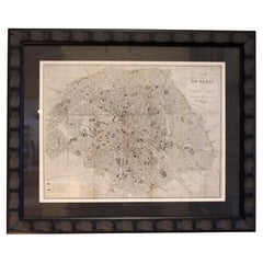
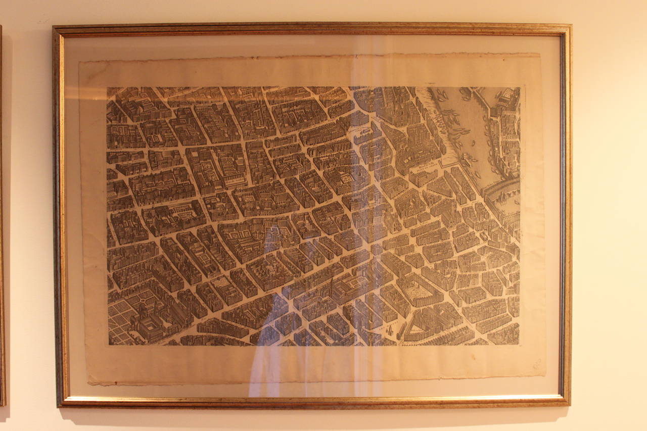
Turgot's 1739 "Plan de Paris"
By Michel Etienne Turgot
Located in Stamford, CT
A stunning 1950's copy ( 117/1000 ) of Turgot's 1739 "Plan de Paris". This remarkable map shows the whole of 18th century Paris and offers a wonderful perspective of the city prior t...
Oak, Paper
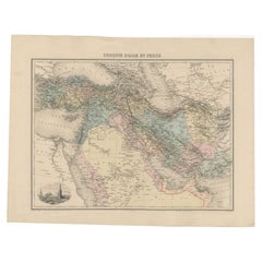
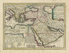
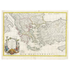
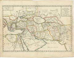
Antique Map of the Turkish Empire and Persia, c.1890
By J. Migeon
Located in Langweer, NL
Migeon (fl. c. 1855 - 1899) was a late 19th century map publisher based in Paris, France. His most prominent publications are the Geographie Universal in 1854 (updated through 1874) ...
Paper
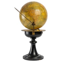
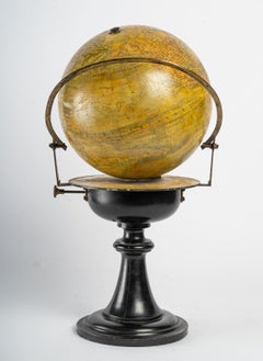
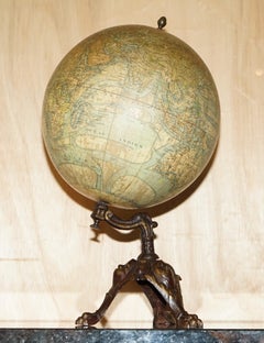
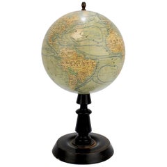
Early 20th Century Terrestrial Globe by G. Thomas Paris
By G. Thomas, Éditeur
Located in Pease pottage, West Sussex
Early 20th Terrestrial Globe by G. Thomas. 44 Rue ND des Champs, Paris. Found on original ebonised turned base and brass fittings. Paris, France Circa 1920.
Wood, Paper
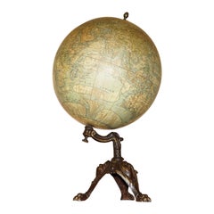
ANTiQUE CIR 1880 J LEBEGUE & CIE PARIS TERRESTRIAL LITHOGRAPH GLOBE CAST IRON
By J. Lebegue & Cie
Located in West Sussex, Pulborough
Royal House Antiques Royal House Antiques is delighted to offer for sale this absolutely exquisite original Circa 1860-1880 Globe Terrestre by J Lebegue & Cie on an ornately cast sw...
Iron


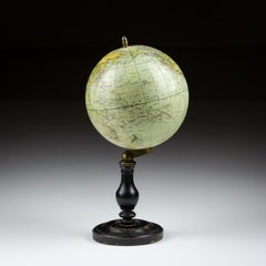
19th Century Small French Antique Terrestrial Globe Editet by J. Forest a Paris
Located in Milan, IT
Small terrestrial published in the early 1870s by the French geographer J. Forest; there are territorial maps, ocean currents and the major trade routes of that period. Papier maché...
Paper

Sold|$795
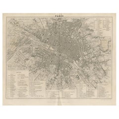
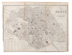
Map of Paris
Located in New York, NY
Black and white map of Paris and surrounding areas. Two different prints available.
Wood
Sold|$3,200
18th Century Map of Paris
Located in Washington, DC
18th century map of Paris.
Glass, Wood, Paper
Sold|$5,100 / set
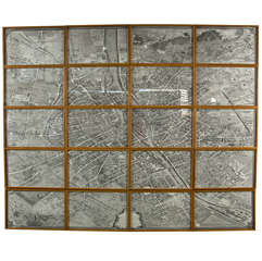
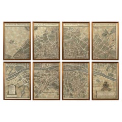
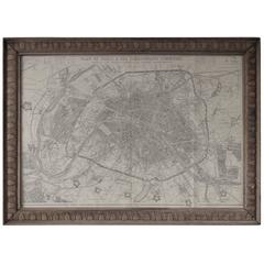
Vintage Paris Maps in Eight Parts
Located in New York, NY
Each hand-colored sheet depicts a distinct section of the city, together composing one large, detailed cartographic view. Featuring rivers, streets, fortifications, and surrounding c...
Paper

1830, French Map of Paris by De Simencourt
Located in Chapel Hill, NC
1830 French map of Paris by De Simencourt, printed by H. Langlois.
Glass, Wood, Paper

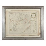
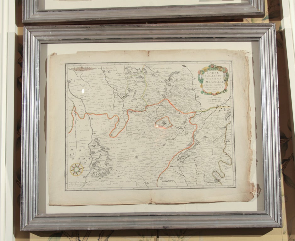
19th c. French maps of suburbs of Paris
Located in Round Top, TX
French maps of suburbs of Paris recently framed in gold.
Sold|$1,632 / set
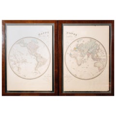
Pair of Hand Colore French Maps by Goujon, Paris
By Andriveau-Goujon
Located in Roma, IT
Maison Andriveau-Goujon, one of the most important French publishing house of the nineteenth century, was based in the heart of Paris at 21 Rue du Bac. The original engravings of thi...
Wood, Paper


Antique Travel Book, Baedeker’s Paris and its Environs, Maps, Guide, Victorian
Located in Hele, Devon, GB
Original bound copy of Baedeker’s Paris and its Environs - this edition printed in 1888 Features 373 pages, with an additional 32 pages of addenda Illustrated with 9 maps and 30 deta...
Paper
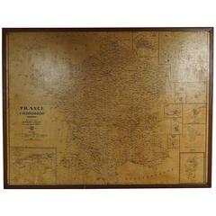
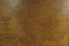
Large Framed School Map of France Drawn and Produced by Andre Lesot, Paris
Located in Nashville, TN
Large framed school map of France drawn and produced by Andre Lesot, Paris.
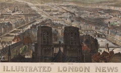
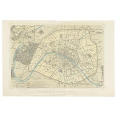
Paris in 1848 Bird's-Eye View, Published by Illustrated London News, Antique Map
Located in Colorado Springs, CO
This 1848 panoramic bird's-eye view of Paris was issued by the Illustrated London News as an insert in its publication. The view was issued by the newspaper as part of a larger serie...
Paper
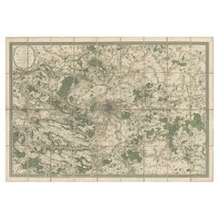
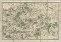
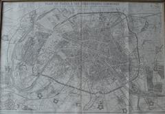
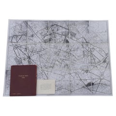
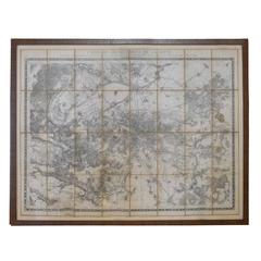
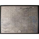
Large Folding Map of Paris, France, on Linen, 36 Segments, Published in 1836
Located in Langweer, NL
Antique map Paris titled 'Carte Topographique des Environs de Paris Nouvelle edition rectifié d'apres les travaux de la Nouvelle Carte De France'.
Paper
Antique Map of Paris by Benoist, '1861'
Located in Langweer, NL
Antique map titled 'Plan de Paris avec ses Agrandissements successifs'.
Paper

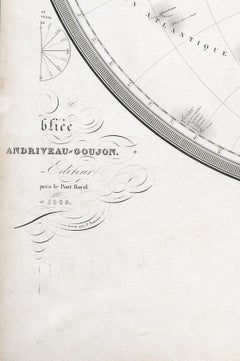
Impressive Large Decorative Antique Map of Paris, France, 1859
Located in Langweer, NL
Published in Paris by E. Andriveau-Goujon, 1859. Condition: Good.
Paper

Antique Map of France with an Inset Map of France in Provinces and Paris, 1882
Located in Langweer, NL
Antique map titled 'France in Departments'. Old map of France with an inset map of France in provinces, Paris and Corse.
Paper
Antique Map of the City of Paris by Balbi '1847'
Located in Langweer, NL
Antique map titled 'Paris'. Original antique map of the city of Paris, France.
Paper
Ottoman Empire Map 1719 – Europe Asia Africa, Jean Chiquet, Paris
Located in Langweer, NL
Title: Ottoman Empire Map 1719 – Europe Asia Africa, Jean Chiquet, Paris Description: Original early-18th-century engraved map titled Estats de l’Empire du Grand Seigneur, depicting...
Paper


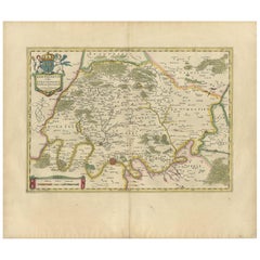
Antique Map of the Region Around Paris by Hondius, c.1625
Located in Langweer, NL
Decorative map of the region around Paris and Île-de-France.
Paper
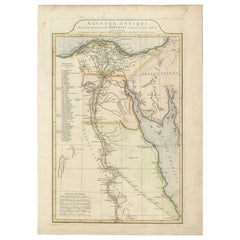
Ancient Egypt Map – Ægyptus Antiqua by D’Anville, Paris circa 1765
Located in Langweer, NL
Ancient Egypt Map – Ægyptus Antiqua by D’Anville, Paris circa 1765 Description: This finely detailed antique map titled "Ægyptus Antiqua" presents an elegant depiction of ancient Eg...
Paper

Decorative Antique Map of the Seine River and Paris in France, ca.1854
By Victor Levasseur
Located in Langweer, NL
Focusing on Paris, this map covers from the Foret de St. Germain to the Bois Notre Dame and from Versailles to Chelles.
Paper

Antique Map of the Region of Paris and the Seine River, circa 1640
Located in Langweer, NL
Detailed map of the area north of the Seine River and Paris, reaching until Senlis.
Paper

Sold|$10,000
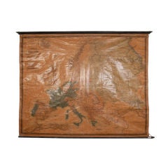
Vintage Map of Europe
Located in Napa, CA
Vintage map of Europe from Paris. The map dates back to the 1850-60's and is in great condition.
Paper, Wood, Ink
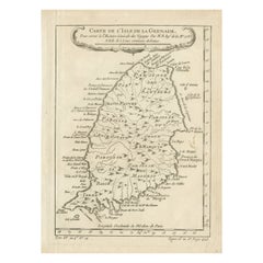

Antique Map of Grenada, West Indies, 1758
Located in Langweer, NL
Dating back to 1758 and originating from Paris, this map serves as both a historical artifact and a visual delight, capturing Grenada's geography and nuances with exquisite detail ch...
Paper

Antique Map of France by A.K. Johnston, 1865
Located in Langweer, NL
Antique map titled 'France in Departments'. With an inset map of France in Provinces, Paris and Corse (or Corsica).
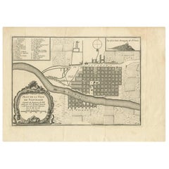
Antique Map of Santiago ‘Chile’ by J.N. Bellin, circa 1760
Located in Langweer, NL
A key identifies 23 churches and other 5 important places on the map. Published in Paris, circa 1760.
Paper


Large Antique Map of Italy with Corsica, Sardinia, Sicily & Malta, 1854
Located in Langweer, NL
Antique map titled 'The States of Italy, with their islands, Corsica, Sardinia, Sicily & Malta, describing the new limits as confirmed by the definitive treaty of Paris 1815.'
Paper

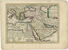
Historical Map of Greece and the Eastern Mediterranean by Delisle - 1780
Located in Langweer, NL
Delisle was one of the most prominent and influential geographers of his time, known for his precision and innovative approach to mapmaking. This map was published in Paris, and the ...
Paper
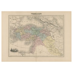

Antique Map Covering the Mid-19th Century Claims of The Ottoman Empire, 1884
Located in Langweer, NL
Migeon (fl. c. 1855 - 1899) was a late 19th century map publisher based in Paris, France. His most prominent publications are the Geographie Universal in 1854 (updated through 1874) ...
Paper
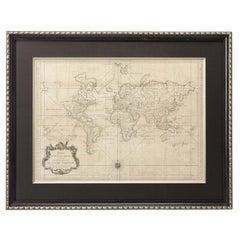
1748 World Map "Essay D'un Carte Requite Du Globe Terrestre" by N. Bellin
Located in Colorado Springs, CO
This is the first edition of Bellin's famous world map, published in 1748 in Paris, France. The map predates the Bay of the West, the discovery of the Sandwich Islands, and many othe...
Paper

French Colonial Map of the Islands of St. Barths, St. Martin and Anguilla, 1890
Located in Langweer, NL
**Title:** Rare French Colonial Map of St. Barth's, St. Martin, and Anguilla **Publisher:** Migeon, Paris **Date:** Circa 1890 The map showcases the islands of St.
Paper

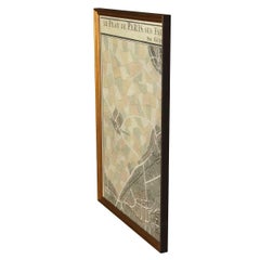
Paris Revealed: A 19th-Century Diagraphe Masterpiece by Gavard, 1832
Located in Langweer, NL
The text in the picture reads: "VUE DE PARIS, dessinée au Diagraphe par Gavard inventeur de l'instrument, et lithographiée par Champin. Chez Gavard, rue Neuve-des-Petits-Champs, Nº ...
Paper

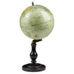
Antique French Terrestrial Globe on Wooden Stand by J. Forest of Paris
By J. Forest
Located in Philadelphia, PA
A wonderful terrestrial globe on an ebonized, turned wooden stand with a brass finial. With 12 gores and 2 polar caps that depict the world's continents, oceans, and major currents....
Wood, Paper

The Expedition of Alexander the Great through Europe, Asia, and Africa, 1654
Located in Langweer, NL
Publication Details: - Year: 1654 - Place: Paris This detailed map showcases the expansive journeys and conquests of Alexander the Great across Europe, Asia, and Africa.
Paper
Original Antique Map of Paris, France, 1863
Located in St Annes, Lancashire
Highly decorative map of Paris. In 19th century distressed carved oak frame.
Oak, Paper

1861 Original vintage map of Paris - Historical cartography
Located in PARIS, FR
It is a window on the past, allowing us to discover the appearance and layout of Paris at a key moment in its history. The fortifications and detached forts depicted on the map bear ...
Paper, Lithograph
Map of Paris -Vintage Offset Print - Early 20th Century
Located in Roma, IT
This map of Paris is an original print. The state of preservation of the artwork is aged with diffused foxings.
Black and White

Exceptional Old Paris France Map from 1853 in a Hermès Leather Case
By Hermès
Located in Corcoué Sur Logne, Loire-Atlantique
Rare old map of Paris in 1853, coming back from very far !
French 1930s Map of Paris à Vol d'Oiseau under Glass in Custom Iron Frame
Located in Atlanta, GA
A French map of Paris from the early 20th century, with custom iron frame.
Iron


Sold|$5,000
Antoine Louis Barye Lion Au Serpent No. 3
By Antoine-Louis Barye
Located in Dallas, TX
.), width 6.65 inches, depth 4.5 inches This Lion and Serpent is the rarest of his three versions and put Barye on the map in Paris as the top animalier sculptor. As he made large...
Bronze

Sold|$4,800
19th Century Map of Paris
Located in Round Top, TX
A folding pocket map of Paris from the French war department, 1839, mounted on silk in a new frame.
Paper

19th Century Copy of Paris Map Acrylic, circa 1739
Located in Atlanta, GA
19th century copy of Paris map acrylic, circa 1739.
Acrylic

Framed Antique Map of Southern France & the Mediterranean Found in Paris
Located in Houston, TX
his antique map was rolled up and tucked away inside a Parisian antique market stall when we discovered it. The piece has been repaired, and is in wonderful condition. The exact age ...
Paper
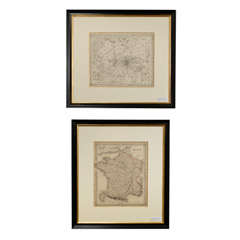

Pair of Antique French Print Maps c1856
By Fred Reed Picture Framing Inc.
Located in Atlanta, GA
This is a pair of antique French maps. One is of France. The other is titled, 'Environs of Paris' which is a detail of Paris.
Sold|$11,000
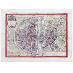
An Important Renaissance View Of Paris
By Georg Braun and Frans Hogenberg
Located in New York, NY
The artistic merit of this particular plate is extremely high, and it reflects many of the same high standards of quality, in terms of color, engraving, and decoration, that charact...


Sold|$14,000
18th Century Paris Map Screen
Located in San Francisco, CA
FOUR- PANEL SCREEN WITH ANTIQUE MAP OF PARIS Printed 1734
Wood
MAP OF PARIS TURGOT, MINT CONDITION
Located in Los Angeles, CA
Stunning map of Paris, also known as the Turgot Map, named after the head of the municipality of Paris, Michel Etienne Turgot who commissioned a new map of the city in 1739.
Lithograph, Paper
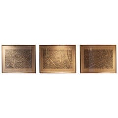
Set of Three Large Copperplate Engravings of Maps of Paris, France, 19th Century
Located in San Antonio, TX
Wonderful set of three large format copperplate engravings of Paris maps from the 19th century and possibly earlier.
Paper
Sold|$2,500
17th century French Map
Located in Seattle, WA
French map dated 1653, wonderful frame. This map shows the area below Paris and includes Paris.
Paper


Sold|$650
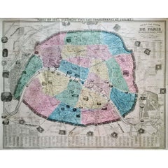
Paris Dans Sa Splendeur. Plan De Paris Avec Ses Agrandissements Successies
By Henri Charpentier
Located in Florham Park, NJ
Charpentier, Edit. - Paris, 1861 Beautiful map of Paris with inset of the (evirons).
Lithograph
It's hard to resist the allure of a beautiful pool. So, go ahead and daydream about whiling away your summer in paradise.
It’s never too early for good design. These interiors combine elevated furnishings and a youthful spirit, resulting in spaces that are at once elegant and whimsical.
Produced in 1843, the well-preserved volume is evidence of the author's exacting specifications.
New or old, the coverlets add old-time charm to any space.
Get into the games! These items celebrate the events, athletes, host countries and sporting spirit.
French trendsetter and serial collector Daniel Rozensztroch tells us about his obsession with objects related to seafaring men.
The sought-after designer worked with the team at Hoffman Creative to produce a monograph that beautifully showcases some of Studio Shamshiri's most inspiring projects.
Italian writer and collector Umberto Pasti opens the doors to his remarkable cave of wonders in North Africa.