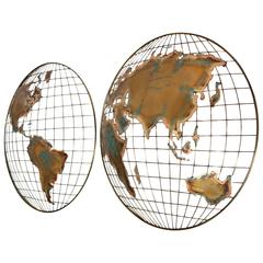
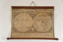
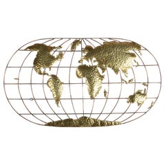
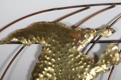
Curtis Jere Modernist World Map/Globe Sculpture
By Curtis Jeré
Located in San Diego, CA
Wall mounted continents/world map/globe/hemispheres sculpture from C. Jere in excellent vintage
Category
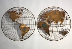
Curtis Jere Modernist World Map/Globe Sculpture
By Curtis Jeré
Located in San Diego, CA
Wall mounted continents/world map/globe/hemispheres sculpture from C. Jere in excellent vintage
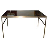
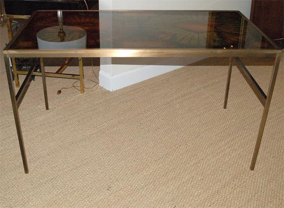
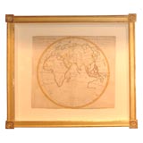
One of a kind desk
Located in North Miami, FL
Fornasetti & discuss the hemispheres on a world map & speak in early Latin in the Italian Renaissance era
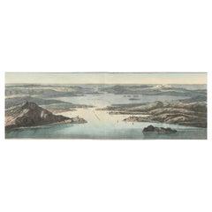
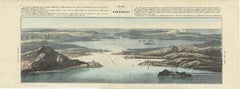
The Dardanelles Strait: A Strategic Passage in a Colored Lithograph, 1853
Located in Langweer, NL
contains 16 lithographic maps and views, some double page. They depict the solar system, the Figure of the
Paper
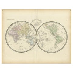
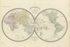
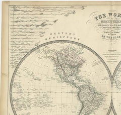
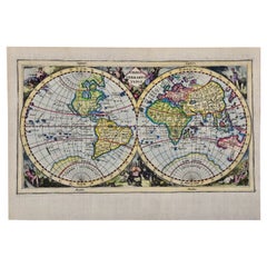
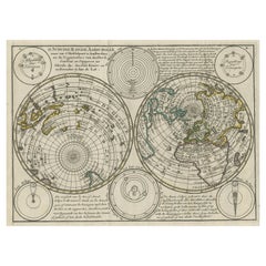
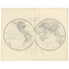
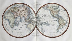
Antique Hemisphere Map of the World by Levasseur, 1875
Located in Langweer, NL
Antique map titled 'Mappemonde en deux Hémisphéres'. Large hemisphere world map. This map
Paper

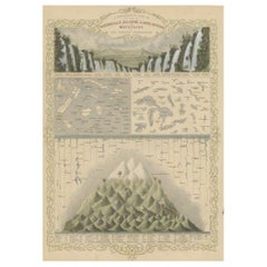
Antique World Map by A.K. Johnston, 1854
By Alexander Keith Johnston
Located in Langweer, NL
Decorative double hemisphere map of the world, showing the comparative heights of mountains of the
Paper
Sold|$4,164
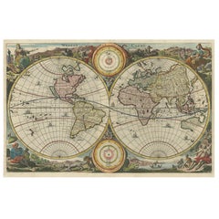
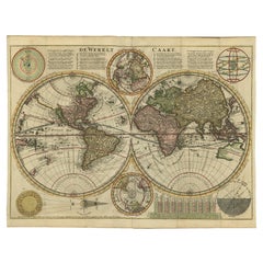
Antique World Map by Stoopendaal, circa 1680
Located in Langweer, NL
Antique map of the world titled 'Werelt Caert'. Double-hemisphere map of the world, with California
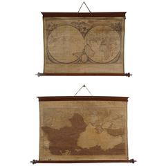
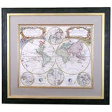
A Set of Two Late 18th-Century Wall Maps in Original Wood Mounts
Located in Kinderhook, NY
'cornices' and bottom 'pole' mounts with turned end finials. Hemispheric map is entitled "Nouvelle Mappe
"Orbis Terrarum Typus" Cluver 17th C Hand-colored World Map, CA as an Island
By Philipp Clüver
Located in Alamo, CA
A hand-colored double hemisphere map of the world entitled "Orbis Terrarum Typus", which appears to
Paper
Curtis Jere Style Brass & Copper World Globe Map, Signed Faye
By C. Jeré Artisan House, Curtis Jeré
Located in St. Louis, MO
1970s world hemisphere map, made of copper and textured brass with artisan signature Faye in black
Brass, Copper

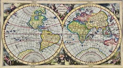
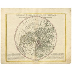
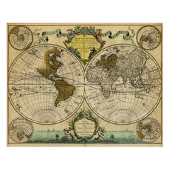
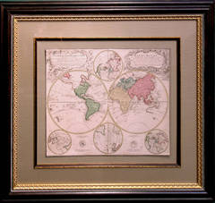
Double Hemisphere World Map on Polar Projections & California Island, 1788
Located in Langweer, NL
(..)'. Interesting double hemisphere world map on polar projections. In North America, there is a large Island of
Paper

Antique Map of a Celestial Hemisphere by Van Dùren, 1749
Located in Langweer, NL
(..)'. Original antique map of a celestial hemisphere, with descriptive text in German. This map originates from
Paper
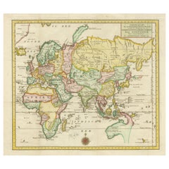
Antique Map of the Northern Hemisphere by A. Zatta, 1779
By Antonio Zatta
Located in Langweer, NL
Antique map of the northern hemisphere based largely on the work of De Vaugondy in 1774. This map

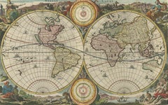
Antique Double Hemisphere World Map with California as an Island, 1710
Located in Langweer, NL
hemisphere world map from a Dutch bible by Cornelis Dankerts (Danckerts), engraved by Albert Schut, printed
Paper

Antique Map of the Eastern Hemisphere, with Australia Connected to New Guinea
Located in Langweer, NL
Antique map titled 'Nieuwe Kaart van het Oostelykste Deel der Weereld, diendende tot aanwyzing van
Paper
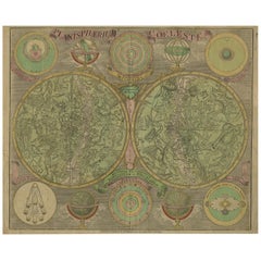

Antique Double Hemisphere Celestial Chart by Lotter, 'circa 1770'
Located in Langweer, NL
Antique map titled 'Planisphaerium Coeleste'. A very decorative double hemisphere celestial chart
Paper


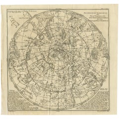
Antique Celestial Charts of the Northern and Southern Hemispheres, 1884
Located in Langweer, NL
Antique Celestial Charts of the Northern and Southern Hemispheres, 1884 This finely engraved
Paper
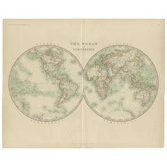

Antique Map of the World by Johnston '1909'
Located in Langweer, NL
Antique map titled 'The World in Hemispheres'. Original antique world map. This map originates from
Paper
Antique Map of the World by A.K. Johnston, 1865
Located in Langweer, NL
Antique map titled 'The World in Hemispheres'. This map originates from the ‘Royal Atlas of Modern

Original Hand-Colored Antique Map Illustrating Routes of Naval Explorers, C.1740
Located in Langweer, NL
Sciences. Nova Orbis Tabula ad Usum Serenissimi Burgundiae Ducis.' Double hemisphere world map
Paper

Old Print Showing New Zealand, Cuba, Iceland etc. Lakes, Mountains, Rivers, 1851
Located in Langweer, NL
Mountains in the Western Hemisphere'. This map depicts the islands of New Zealand, Cuba, Iceland etc., the
Paper

Atlas geographique contenant la Mappemonde, avec les differents etats d'Europe
By Giovanni Antonio Rizzi-Zannoni
Located in New York, NY
two hemispheric maps, one of Asia and Europe and the other of the Americas followed by maps of the
Leather, Engraving
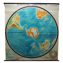
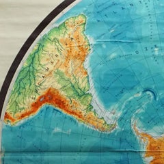
Southern Hemisphere of the Earth Rollable Map Vintage Wall Chart
Located in Berghuelen, DE
A great pull-down map or vintage wall chart illustrating the southern hemisphere of the earth
Canvas, Wood, Paper


1903 "Barnum & Bailey Circus, " Antique Advertisement Poster
Located in Colorado Springs, CO
two hemispheric map depictions of the world, and was so large it required a team of 40 horses to pull
Paper


Wooden Eastern and Western Hemisphere Map
Located in Los Angeles, CA
Framed, wooden set of western and eastern hemisphere maps. In wood, hand finished. custom finishes
Wood

Sold|$3,250
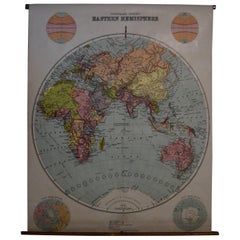
Eastern Hemisphere map
Located in Los Angeles, CA
This is a map of the Eastern Hemisphere, and was printed in Paris by the Quai De L'Horlogue


Sold|$9,600
Western & Eastern Hemisphere Maps
Located in Los Angeles, CA
German maps of the Western and Eastern Hemispheres.
Paper


Sold|$925
Western Hemisphere Map - Square
Located in West Hollywood, CA
Natural wood framing. Published by George Phillip and Son
Wood

Early 20th Century Map of the Eastern Hemisphere, 1916 Edition
Located in Madison, WI
Archival map of the Eastern Hemisphere, 1916 edition. Printed in Edinburgh, Scotland. Mounted on
Canvas, Paper

Sold|$550
1821 H/C Engraved Map MAPPE-MONDE EN DEUX HÉMISPHÈRES Adrien-Hubert Brué
Located in Gallatin, TN
Description Antique Early 19th Century Hand-colored Engraved Map of North America by Andre Hubert
Engraving
Sold|$2,990
Planiglobii Terrestris
Located in Florham Park, NJ
example, when the Atlas novus was reissued in 1720, it included a hemispheric map depicting the Americas


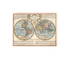
1700 World Map
Located in New York, NY
Original 1700 hand-colored engraving of a double hemisphere map of the world. Designed by Denis
Engraving

1706 de La Feuille Map of the World
Located in New York, NY
Original hand-colored 1706 double hemisphere map. Features the island of California, a large
Engraving
Planiglobii Terrestris Mappa Universalis
By Homann Heirs
Located in Florham Park, NJ
, it included a hemispheric map depicting the Americas from Greenland to Tierra del Fuego
Engraving

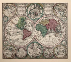
1729 French World Map showing California as an Island
By Jacques Chiquet
Located in New York, NY
Beautifully hand-colored 1729 engraving of a double-hemisphere French world map, titled "Le Globe
Engraving

Sold|$450
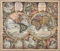
World Map entitled "Diversi Globi Terr-Aquei Statione Variante" by Seutter
Located in New York, NY
Georg Matthaus Seutter (1678-1757). This map has 14 hemispheric projections of all the continents and
Etching

World Map entitled "Diversi Globi Terr-Aquei Statione Variante" by Seutter
By Georg Matthaus Seutter
Located in New York, NY
map has 14 hemispheric projections of all the continents and regions, blow heads, indicating climate
Engraving