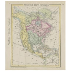
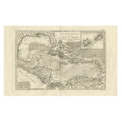
The Caribbean & Gulf of Mexico – Rigobert Bonne’s Antilles Map, c.1780
Description:
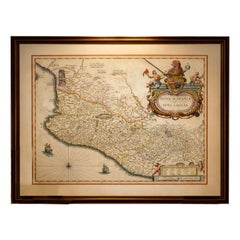
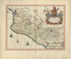
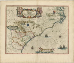
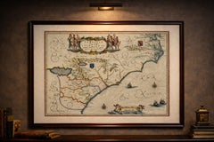
This detailed late 18th-century map depicts the Caribbean region and the Gulf of Mexico at a moment of intense colonial, commercial, and maritime activity. Engraved around 1780 by the distinguished French cartographer Rigobert Bonne, the map reflects the Enlightenment emphasis on clarity, accuracy, and practical geographic knowledge.
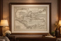
This original antique engraving is offered unframed, enabling custom framing to personal or interior preferences.
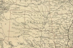
The map encompasses the Antilles in their full extent, including Cuba, Hispaniola (Saint-Domingue), Jamaica, Puerto Rico, the Lesser Antilles, and the Virgin Islands, together with the surrounding mainland coastlines of Florida, New Spain (Mexico), Central America, and northern South America. The Gulf of Mexico is shown in detail, with clearly articulated coastlines, river mouths, ports, and settlements that underline the strategic importance of the region for European naval powers.
An inset map of Bermuda appears in the upper right, emphasizing its role as a key Atlantic outpost. The Tropic of Cancer is marked, and a structured coordinate grid reinforces the scientific intent of the composition. Shaded sea areas and fine engraved hachures provide visual depth while maintaining the restrained, analytical aesthetic for which Bonne is known.
As Hydrographer to the French Navy, Bonne synthesized the latest geographic intelligence into maps intended for navigation, administration, and strategic planning. This sheet illustrates the Caribbean world shortly before major geopolitical changes, including the later phases of colonial rivalry and the transformative events of the late 18th and early 19th centuries. Today, such maps are valued for both their historical insight and their balanced, elegant appearance.
This example is particularly attractive to collectors of Caribbean and colonial American cartography, maritime history, and Enlightenment-era maps. Its expansive scope and refined engraving also make it a strong decorative piece, suitable for libraries, studies, or contemporary interiors seeking a historically grounded focal point.
Condition report:
Good condition. Light age toning throughout with small scattered spots and minor handling marks consistent with age. Central fold visible as issued. Plate mark present.
Framing tips:
A wide off-white or soft ivory mat will enhance the engraved detail and provide visual balance. A dark walnut, blackened wood, or subtle antique gilt frame complements the map’s scholarly and maritime character and works well in both classic and modern interiors.
Keyword block:
Antique Caribbean map...
Category
Late 18th Century French Antique Spanish Colonial Maps