B. Schotanus Prints
to
3
3
3
Height
to
Width
to
3
3
3
3
3
12
107
104
93
80
Creator: B. Schotanus
Antique Map of the Region of Utingeradeel in Friesland, The Netherlands, 1664
By B. Schotanus
Located in Langweer, NL
Antique map titled 'De Grietenye van Utingeradeel (..)'. Map of the Grietenij of Utingeradeel, Friesland, The Netherlands. Multiple cartouches, key and coat of arms. "Beschrijvinge e...
Category
17th Century Antique B. Schotanus Prints
Materials
Paper
Antique Map of the Region of Wonseradeel, Friesland in the Netherlands, 1664
By B. Schotanus
Located in Langweer, NL
Antique map titled 'De Grietenije van Wonsera-deel (..).' Map of the Grietenij of Wonseradeel, Friesland, The Netherlands. Multiple cartouches, key and coat of arms. "Beschrijvinge e...
Category
17th Century Antique B. Schotanus Prints
Materials
Paper
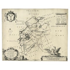
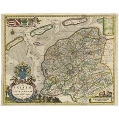
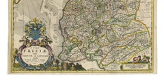
Antique Map of Friesland 'The Netherlands' by B. Schotanus, 1664
By B. Schotanus
Located in Langweer, NL
Hand-colored map of the Dutch province Friesland. Also shows the Wadden islands Vlieland, Terschelling and Ameland and a part of Schiermonnikoog. With a decorative cartouche with two...
Category
Late 17th Century Antique B. Schotanus Prints
Materials
Paper
Related Items
Antique Map of Principality of Monaco
By Antonio Vallardi Editore
Located in Alessandria, Piemonte
ST/619 - "Old Geographical Atlas of Italy - Topographic map of ex-Principality of Monaco" -
ediz Vallardi - Milano -
A somewhat special edition ---
Category
Late 19th Century Italian Other Antique B. Schotanus Prints
Materials
Paper
Original Antique Map of Ancient Greece, Achaia, Corinth, 1786
Located in St Annes, Lancashire
Great map of Ancient Greece. Showing the region of Thessaly, including Mount Olympus
Drawn by J.D. Barbie Du Bocage
Copper plate engraving by P.F Tardieu
Original hand color...
Category
1780s French Other Antique B. Schotanus Prints
Materials
Paper
Original Antique Map of Spain and Portugal, circa 1790
Located in St Annes, Lancashire
Super map of Spain and Portugal
Copper plate engraving by A. Bell
Published, circa 1790.
Unframed.
Category
1790s English Other Antique B. Schotanus Prints
Materials
Paper
New Map of North America from the Latest Discoveries, 1763
Located in Philadelphia, PA
A fine antique 18th century map of the North American seaboard.
Entitled "A New Map of North America from the Latest Discoveries 1763".
By the Cartographer/Engraver - John Spil...
Category
Mid-18th Century English Georgian Antique B. Schotanus Prints
Materials
Paper
"San Francisco, Upper California” 1851 Antique Map of San Francisco
Located in Colorado Springs, CO
This is a pictorial lettersheet view of the city and harbor of San Francisco. This lithograph was printed on grey wove paper, across a double sheet, by famed lithographers Britton & ...
Category
1850s American Antique B. Schotanus Prints
Materials
Paper
Original Antique Map of Ancient Greece- Boeotia, Thebes, 1787
Located in St Annes, Lancashire
Great map of Ancient Greece. Showing the region of Boeotia, including Thebes
Drawn by J.D. Barbie Du Bocage
Copper plate engraving by P.F T...
Category
1780s French Other Antique B. Schotanus Prints
Materials
Paper
Original Antique Map of Europe, Arrowsmith, 1820
Located in St Annes, Lancashire
Great map of Europe
Drawn under the direction of Arrowsmith.
Copper-plate engraving.
Published by Longman, Hurst, Rees, Orme and Brown, 1820
...
Category
1820s English Antique B. Schotanus Prints
Materials
Paper
Original Antique Map of South East Asia by Thomas Clerk, 1817
Located in St Annes, Lancashire
Great map of South East Asia
Copper-plate engraving
Drawn and engraved by Thomas Clerk, Edinburgh.
Published by Mackenzie And Dent, 1817
Unframed.
Category
1810s English Antique B. Schotanus Prints
Materials
Paper
Map of the Holy Land "Carte de la Syrie et de l'Egypte" by Pierre M. Lapie
By Pierre M. Lapie
Located in Alamo, CA
An early 19th century map of ancient Syria and Egypt entitled "Carte de la Syrie et de l'Egypte anciennes/dressée par M. Lapie, Colonel d'Etat Major, et...
Category
Early 19th Century French Antique B. Schotanus Prints
Materials
Paper
H 27 in W 21.38 in D 0.75 in
Original Antique Map of Sweden, Engraved by Barlow, 1806
Located in St Annes, Lancashire
Great map of Sweden
Copper-plate engraving by Barlow
Published by Brightly & Kinnersly, Bungay, Suffolk. 1806
Unframed.
Category
Early 1800s English Antique B. Schotanus Prints
Materials
Paper
Original Antique Map of Ireland- Kerry. C.1840
Located in St Annes, Lancashire
Great map of Kerry
Steel engraving
Drawn under the direction of A.Adlard
Published by How and Parsons, C.1840
Unframed.
Category
1840s English Antique B. Schotanus Prints
Materials
Paper
Vintage "View of the Center of Paris Taken from the Air" Lithograph Map
Located in San Diego, CA
A very stylish "View of the Center of Paris Taken from the Air" lithograph map published by the Paris Ministry of Tourism, circa early 1950s. The piece measures 27" x 43" and shows...
Category
20th Century French Mid-Century Modern B. Schotanus Prints
Materials
Paper
B. Schotanus prints for sale on 1stDibs.
B. Schotanus prints are available for sale on 1stDibs. These distinctive items are frequently made of paper and are designed with extraordinary care. There are many options to choose from in our collection of B. Schotanus prints, although beige editions of this piece are particularly popular. If you’re looking for additional options, many customers also consider prints by Vincenzo Coronelli, Homann Heirs, and Covens & Mortier. Prices for B. Schotanus prints can differ depending upon size, time period and other attributes — on 1stDibs, these items begin at $205 and can go as high as $1,268, while a piece like these, on average, fetch $313.