
Covens & Mortier Furniture

to
7
7
7
7
7
7
7
7
7
11,549
3,905
2,408
2,232
Creator: Covens & Mortier
Detailed Antique Map of the Windward Islands in the Caribbean
By Covens & Mortier
Located in Langweer, NL
Antique map titled 'Carte des Antilles Francoises et des Isles Voisines'. Original antique map of the French Antilles, covering an area stretching from Guadeloupe in the north to Gre...
Category

Early 18th Century Antique Covens & Mortier Furniture

Materials

Paper

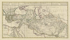
Antique Map of the Northern Coast of Africa and Southern Europe, circa 1745
By Covens & Mortier
Located in Langweer, NL
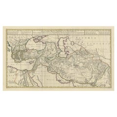
Antique map titled 'In Notitiam Ecclesiasticam Africae Tabula Geographica'. Very decorative hand-colored map of the northern coast of Africa, Spain, Italy and the Mediterranean with the islands of Sardinia, Corsica, Majorca, Minorca etc. Sicily features a smoking Mount Aetna. Embellished with three architectural cartouches...
Category

Mid-18th Century Antique Covens & Mortier Furniture

Materials

Paper

Antique Map of the Diocese of Toul by Covens & Mortier, circa 1720
By Covens & Mortier
Located in Langweer, NL
Antique map titled 'Civitas Leucorum sive Pagus Tullensis'. Detailed map of the Diocese of Toul, France. Centered on the cities of Nancy and Toul and including Metz, Verdun, S. Dizie...
Category

Early 18th Century Antique Covens & Mortier Furniture

Materials

Paper

Antique Map of the British Isles by Covens & Mortier, 1730
By Covens & Mortier
Located in Langweer, NL
Covens and Mortier's attractive double-page engraved map of the British Isles, based on the 1702 De L'Isle map. The map features a large car...
Category

Mid-18th Century Antique Covens & Mortier Furniture

Materials

Paper

Denmark and Baltic Region – Antique Map by Guillaume de l’Isle, c.1730
By Covens & Mortier
Located in Langweer, NL
Denmark and Baltic Region – Antique Map by Guillaume de l’Isle, c.1730 This antique map titled Carte du Royaume de Danemark is a detailed 18th-century depiction of Denmark and its surrounding regions. Originally created by renowned French cartographer Guillaume de l’Isle, the map was published around 1730 by the Dutch publishers Covens...
Category

Mid-18th Century Antique Covens & Mortier Furniture

Materials

Paper

Antique Map of the Region of Artois by Covens & Mortier, c.1730
By Covens & Mortier
Located in Langweer, NL
Antique map titled 'Carte d'Artois et des environs'. Large map of the region of Artois, France. Artois is former province located in the northwestern part of France, boarding Belgium...
Category

18th Century Antique Covens & Mortier Furniture

Materials

Paper

Antique Map 'Colored Cartouches' of the British Isles by Covens & Mortier ‘1761’
By Covens & Mortier
Located in Langweer, NL
Covens and Mortier's attractive double-page engraved map of the British Isles, based on the 1702 De L'Isle map. The map features a large car...
Category

Late 18th Century Antique Covens & Mortier Furniture

Materials

Paper

Related Items
Antique Map of Principality of Monaco
By Antonio Vallardi Editore
Located in Alessandria, Piemonte
ST/619 - "Old Geographical Atlas of Italy - Topographic map of ex-Principality of Monaco" - ediz Vallardi - Milano - A somewhat special edition ---  
Category

Late 19th Century Italian Other Antique Covens & Mortier Furniture

Materials

Paper

Antique Map of Principality of Monaco
$449
H 22.84 in W 15.75 in D 0.04 in
Original Antique Map of The London Underground. 1911
Located in St Annes, Lancashire
Superb map of The London Underground Published by Ward Lock, 1911 Folding map. Printed on paper Unframed. Good condition/ Minor repair to an edge tear on right edge ( shown in ...
Category

1910s English Vintage Covens & Mortier Furniture

Materials

Canvas, Paper

New Map of North America from the Latest Discoveries, 1763
Located in Philadelphia, PA
A fine antique 18th century map of the North American seaboard. Entitled "A New Map of North America from the Latest Discoveries 1763". By the Cartographer/Engraver - John Spil...
Category

Mid-18th Century English Georgian Antique Covens & Mortier Furniture

Materials

Paper

Antique Map of Virginia & the Chesapeake Bay by Jacques-Nicolas Bellin, c. 1750
By Jacques-Nicolas Bellin
Located in Philadelphia, PA
A fine antique 18th century French map of North America. By Jacques-Nicolas Bellin. On laid paper with polychrome highlights. Depicting Virginia, the Chesapeake Bay, and the nearb...
Category

18th Century French Baroque Antique Covens & Mortier Furniture

Materials

Paper

Original Antique Map of Ancient Greece, Achaia, Corinth, 1786
Located in St Annes, Lancashire
Great map of Ancient Greece. Showing the region of Thessaly, including Mount Olympus Drawn by J.D. Barbie Du Bocage Copper plate engraving by P.F Tardieu Original hand color...
Category

1780s French Other Antique Covens & Mortier Furniture

Materials

Paper

18th Century Map of French Pyrenees Region of France
Located in Haddonfield, NJ
An antique map titled "Principatus Benearnia, La Principaute De Bearn" created by the renowned Dutch cartographer Willem Janszoon Blaeu. It depicts the Principality of Bearn, a histo...
Category

1880s Danish Baroque Antique Covens & Mortier Furniture

Materials

Wood, Paper

Vintage "View of the Center of Paris Taken from the Air" Lithograph Map
Located in San Diego, CA
A very stylish "View of the Center of Paris Taken from the Air" lithograph map published by the Paris Ministry of Tourism, circa early 1950s. The piece measures 27" x 43" and shows...
Category

20th Century French Mid-Century Modern Covens & Mortier Furniture

Materials

Paper

Map of the Republic of Genoa
Located in New York, NY
Framed antique hand-coloured map of the Republic of Genoa including the duchies of Mantua, Modena, and Parma. Europe, late 18th century. Dimension: 25...
Category

Late 18th Century European Antique Covens & Mortier Furniture

Map of the Republic of Genoa
$750
H 22.5 in W 25.75 in D 0.75 in
17th Century Map of Denmark by French Cartographer Sanson, Dated 1658
By Nicolas Sanson
Located in Copenhagen, K
17th century map of Denmark by French cartographer Sanson. Nicolas Sanson (20 December 1600-7 July 1667) was a French cartographer, termed by some the creator of French geography an...
Category

17th Century French Antique Covens & Mortier Furniture

Materials

Paper

Original Antique Map of The World by Dower, circa 1835
Located in St Annes, Lancashire
Nice map of the World Drawn and engraved by J.Dower Published by Orr & Smith. C.1835 Unframed. Free shipping
Category

1830s English Antique Covens & Mortier Furniture

Materials

Paper

Antique 18th Century Map of the Province of Pensilvania 'Pennsylvania State'
Located in Philadelphia, PA
A fine antique of the colony of Pennsylvania. Noted at the top of the sheet as a 'Map of the province of Pensilvania'. This undated and anonymous map is thought to be from the Gentleman's Magazine, London, circa 1775, although the general appearance could date it to the 1760's. The southern boundary reflects the Mason-Dixon survey (1768), the western boundary is placed just west of Pittsburgh, and the northern boundary is not marked. The map has a number of reference points that likely refer to companion text and appear to be connected to boundaries. The western and southern boundaries are marked Q, R, S, for example. A diagonal line runs from the Susquehanna R to the Lake Erie P. A broken line marked by many letters A, B, N, O, etc., appears in the east. There are no latitude or longitude markings, blank verso. Framed in a shaped contemporary gilt wooden frame and matted under a cream colored matte. Bearing an old Graham Arader Gallery...
Category

18th Century British American Colonial Antique Covens & Mortier Furniture

Materials

Paper

Old Horizontal Map of England
By Tasso
Located in Alessandria, Piemonte
ST/520 - Old rare Italian map of England, dated 1826-1827 - by Girolamo Tasso, editor in Venise, for the atlas of M.r Le-Sage.
Category

Early 19th Century Italian Other Antique Covens & Mortier Furniture

Materials

Paper

Old Horizontal Map of England
$709
H 15.75 in W 21.26 in D 0.04 in
Previously Available Items
Large Map of Alexander the Great's Conquests from Macedonia to Persia and Africa
By Covens & Mortier
Located in Langweer, NL
Antique map titled 'Alexandri Magni Imperium et Expeditio (..)'. Detailed map of the Empire of Alexander the Great, including the regions to the east which were the subject of his ex...
Category

Mid-18th Century Antique Covens & Mortier Furniture

Materials

Paper

Antique Map of Switzerland by Covens & Mortier, 1749
By Covens & Mortier
Located in Langweer, NL
Antique map titled 'Nova Helvetiae, Foederatarumque cum ea, nec non Subditarum Regionum Tabula'. Old map of Switzerland by Covens and Mortie...
Category

Mid-18th Century Antique Covens & Mortier Furniture

Materials

Paper

Covens & Mortier furniture for sale on 1stDibs.

Covens & Mortier furniture are available for sale on 1stDibs. These distinctive items are frequently made of paper and are designed with extraordinary care. There are many options to choose from in our collection of Covens & Mortier furniture, although beige editions of this piece are particularly popular. If you’re looking for additional options, many customers also consider furniture by Philip Baldaeus, Abraham Ortelius, and Arnoldus Montanus. Prices for Covens & Mortier furniture can differ depending upon size, time period and other attributes — on 1stDibs, these items begin at $277 and can go as high as $1,065, while a piece like these, on average, fetch $535.

Recently Viewed

View All