
Covens & Mortier Furniture

to
5
7
7
7
7
1
1
7
7
7
7
12,511
3,601
2,599
2,307
Creator: Covens & Mortier
Antique Map 'Colored Cartouches' of the British Isles by Covens & Mortier ‘1761’

Antique Map 'Colored Cartouches' of the British Isles by Covens & Mortier ‘1761’

By Covens & Mortier

Located in Langweer, NL

Covens and Mortier's attractive double-page engraved map of the British Isles, based on the 1702 De L'Isle map. The map features a large car...

Category

Late 18th Century Antique Covens & Mortier Furniture

Materials

Paper

Antique Map of the Northern Coast of Africa and Southern Europe, circa 1745

Antique Map of the Northern Coast of Africa and Southern Europe, circa 1745

By Covens & Mortier

Located in Langweer, NL

Antique map titled 'In Notitiam Ecclesiasticam Africae Tabula Geographica'. Very decorative hand-colored map of the northern coast of Africa, Spain, Italy and the Mediterranean with the islands of Sardinia, Corsica, Majorca, Minorca etc. Sicily features a smoking Mount Aetna. Embellished with three architectural cartouches...

Category

Mid-18th Century Antique Covens & Mortier Furniture

Materials

Paper

Detailed Antique Map of the Windward Islands in the Caribbean

Detailed Antique Map of the Windward Islands in the Caribbean

By Covens & Mortier

Located in Langweer, NL

Antique map titled 'Carte des Antilles Francoises et des Isles Voisines'. Original antique map of the French Antilles, covering an area stretching from Guadeloupe in the north to Gre...

Category

Early 18th Century Antique Covens & Mortier Furniture

Materials

Paper

Antique Map of the Region of Artois by Covens & Mortier, c.1730

Antique Map of the Region of Artois by Covens & Mortier, c.1730

By Covens & Mortier

Located in Langweer, NL

Antique map titled 'Carte d'Artois et des environs'. Large map of the region of Artois, France. Artois is former province located in the northwestern part of France, boarding Belgium...

Category

18th Century Antique Covens & Mortier Furniture

Materials

Paper

Antique Map of the Diocese of Toul by Covens & Mortier, circa 1720

Antique Map of the Diocese of Toul by Covens & Mortier, circa 1720

By Covens & Mortier

Located in Langweer, NL

Antique map titled 'Civitas Leucorum sive Pagus Tullensis'. Detailed map of the Diocese of Toul, France. Centered on the cities of Nancy and Toul and including Metz, Verdun, S. Dizie...

Category

Early 18th Century French Antique Covens & Mortier Furniture

Materials

Paper

Denmark and Baltic Region – Antique Map by Guillaume de l’Isle, c.1730

Denmark and Baltic Region – Antique Map by Guillaume de l’Isle, c.1730

By Covens & Mortier

Located in Langweer, NL

Denmark and Baltic Region – Antique Map by Guillaume de l’Isle, c.1730 This antique map titled Carte du Royaume de Danemark is a detailed 18th-century depiction of Denmark and its surrounding regions. Originally created by renowned French cartographer Guillaume de l’Isle, the map was published around 1730 by the Dutch publishers Covens...

Category

Mid-18th Century Antique Covens & Mortier Furniture

Materials

Paper

Antique Map of the British Isles by Covens & Mortier, 1730

Antique Map of the British Isles by Covens & Mortier, 1730

By Covens & Mortier

Located in Langweer, NL

Covens and Mortier's attractive double-page engraved map of the British Isles, based on the 1702 De L'Isle map. The map features a large car...

Category

Mid-18th Century Antique Covens & Mortier Furniture

Materials

Paper

Related Items
Map of the Holy Land "Carte de la Syrie et de l'Egypte" by Pierre M. Lapie

Map of the Holy Land "Carte de la Syrie et de l'Egypte" by Pierre M. Lapie

By Pierre M. Lapie

Located in Alamo, CA

An early 19th century map of ancient Syria and Egypt entitled "Carte de la Syrie et de l'Egypte anciennes/dressée par M. Lapie, Colonel d'Etat Major, et...

Category

Early 19th Century French Antique Covens & Mortier Furniture

Materials

Paper

Large 17th Century Hand Colored Map of England and the British Isles by de Wit

Large 17th Century Hand Colored Map of England and the British Isles by de Wit

By Frederick de Wit

Located in Alamo, CA

A large hand colored 17th century map of England and the British Isles by Frederick de Wit entitled "Accuratissima Angliæ Regni et Walliæ Principatus", published in Amsterdam in 1680. It is a highly detailed map of England, Scotland, the Scottish Isles...

Category

Late 17th Century Dutch Antique Covens & Mortier Furniture

Materials

Paper

Antique Map of Principality of Monaco, Late 19th Century, Paper Print

Antique Map of Principality of Monaco, Late 19th Century, Paper Print

$355Sale Price|62% Off

H 22.84 in W 15.75 in D 0.04 in

Antique Map of Principality of Monaco, Late 19th Century, Paper Print

By Antonio Vallardi Editore

Located in Alessandria, Piemonte

ST/619 - "Old Geographical Atlas of Italy - Topographic map of ex-Principality of Monaco" - ediz Vallardi - Milano - A somewhat special edition ---  

Category

Late 19th Century Italian Other Antique Covens & Mortier Furniture

Materials

Paper

Antique Map of Pisa by Matthäus Merian the Elder, Engraved, 1640

Antique Map of Pisa by Matthäus Merian the Elder, Engraved, 1640

By Matthäus Merian the Elder

Located in Florence, Tuscany

An antique map of the Tuscan city of Pisa engraved for The 'Itinerarium Italiæ Nov-antiquæ' by Matthäus Merian the Elder and printed in 1640....

Category

1640s Italian Antique Covens & Mortier Furniture

Materials

Paper

1807 "A Map of the Country..." by Samuel Lewis, Revolutionary War Map

1807 "A Map of the Country..." by Samuel Lewis, Revolutionary War Map

Located in Colorado Springs, CO

Presented is “A Map of the Country from Rariton River in East Jersey to Elk Head in Maryland, Shewing the several Operations of the American and British Armies, in 1776 & 1777.”  The...

Category

Early 1800s American Federal Antique Covens & Mortier Furniture

Materials

Paper

Original Antique Map of The World by Dower, circa 1835

Original Antique Map of The World by Dower, circa 1835

$48Sale Price|20% Off

H 9.25 in W 12.25 in D 0.07 in

Original Antique Map of The World by Dower, circa 1835

Located in St Annes, Lancashire

Nice map of the World Drawn and engraved by J.Dower Published by Orr & Smith. C.1835 Unframed. Free shipping

Category

1830s English Antique Covens & Mortier Furniture

Materials

Paper

Colored wall map of the WORLD

Colored wall map of the WORLD

$28,084Sale Price|20% Off

H 45 in W 57 in D 0.8 in

Colored wall map of the WORLD

By Chambon

Located in ZWIJNDRECHT, NL

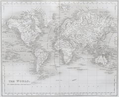
“Mappe Monde, contenant les Parties Connues du Globe Terrestre” CHAMBON, Gobert-Denis (France, 17.. - 1781) Paris, Longchamps et Janvier, 1754 Size H. 115 x W. 145 cm. Gobert-Denis Chambon made copper engraving after the work of Guillaume De L’Isle, published in 1754 by Jean Janvier and S.G. Longschamps. 
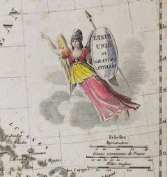
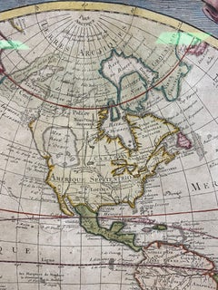
A huge wall map of the world in two hemispheres printed on two sheets, depicting the Eastern and Western hemispheres supported by two male figures, decorated at the bottom right and left with two celestial hemispheres (boreal and southern) and at the bottom in the middle with an armillary sphere, in addition. This map is most notable for its depiction of the Sea of Japan labeled "Mer de Corée" and of "Mer de L'Ouest" or Sea of the West - a great sea, easily the size of the Mediterranean, to flow from the then-known Strait of Juan de Fuca...

Category

Mid-18th Century French French Provincial Antique Covens & Mortier Furniture

Materials

Wood, Paper

Map of the Republic of Genoa

Map of the Republic of Genoa

$750

H 22.5 in W 25.75 in D 0.75 in

Map of the Republic of Genoa

Located in New York, NY

Framed antique hand-coloured map of the Republic of Genoa including the duchies of Mantua, Modena, and Parma. Europe, late 18th century. Dimension: 25...

Category

Late 18th Century European Antique Covens & Mortier Furniture

Early 19th Century Hand Colored Map of the United States and Caribbean Islands

Early 19th Century Hand Colored Map of the United States and Caribbean Islands

Located in Hamilton, Ontario

Hand coloured early 19th century map by Giraldon of France titled "Etats Unis et Grandes Antilles" (United States and Greater Antilles).

Category

Early 19th Century French Antique Covens & Mortier Furniture

Materials

Paper

New Map of North America from the Latest Discoveries, 1763

New Map of North America from the Latest Discoveries, 1763

Located in Philadelphia, PA

A fine antique 18th century map of the North American seaboard. Entitled "A New Map of North America from the Latest Discoveries 1763". By the Cartographer/Engraver - John Spil...

Category

Mid-18th Century English Georgian Antique Covens & Mortier Furniture

Materials

Paper

18th Century Map of French Pyrenees Region of France

18th Century Map of French Pyrenees Region of France

Located in Haddonfield, NJ

An antique map titled "Principatus Benearnia, La Principaute De Bearn" created by the renowned Dutch cartographer Willem Janszoon Blaeu. It depicts the Principality of Bearn, a histo...

Category

1880s Danish Baroque Antique Covens & Mortier Furniture

Materials

Wood, Paper

Original Antique Map of The World by Thomas Clerk, 1817

Original Antique Map of The World by Thomas Clerk, 1817

$72Sale Price / set|20% Off

H 10.25 in W 8.25 in D 0.07 in

Original Antique Map of The World by Thomas Clerk, 1817

Located in St Annes, Lancashire

Great map of The Eastern and Western Hemispheres On 2 sheets Copper-plate engraving Drawn and engraved by Thomas Clerk, Edinburgh. Published by Mackenzie And Dent, 1817 ...

Category

1810s English Antique Covens & Mortier Furniture

Materials

Paper

Previously Available Items
Large Map of Alexander the Great's Conquests from Macedonia to Persia and Africa

Large Map of Alexander the Great's Conquests from Macedonia to Persia and Africa

By Covens & Mortier

Located in Langweer, NL

Antique map titled 'Alexandri Magni Imperium et Expeditio (..)'. Detailed map of the Empire of Alexander the Great, including the regions to the east which were the subject of his ex...

Category

Mid-18th Century Antique Covens & Mortier Furniture

Materials

Paper

Antique Map of Switzerland by Covens & Mortier, 1749

Antique Map of Switzerland by Covens & Mortier, 1749

Sold

H 20.67 in W 26.38 in D 0.02 in

Antique Map of Switzerland by Covens & Mortier, 1749

By Covens & Mortier

Located in Langweer, NL

Antique map titled 'Nova Helvetiae, Foederatarumque cum ea, nec non Subditarum Regionum Tabula'. Old map of Switzerland by Covens and Mortie...

Category

Mid-18th Century Antique Covens & Mortier Furniture

Materials

Paper

Covens & Mortier furniture for sale on 1stDibs.

Covens & Mortier furniture are available for sale on 1stDibs. These distinctive items are frequently made of paper and are designed with extraordinary care. There are many options to choose from in our collection of Covens & Mortier furniture, although beige editions of this piece are particularly popular. If you’re looking for additional options, many customers also consider furniture by Philip Baldaeus, Abraham Ortelius, and Arnoldus Montanus. Prices for Covens & Mortier furniture can differ depending upon size, time period and other attributes — on 1stDibs, these items begin at $277 and can go as high as $1,065, while a piece like these, on average, fetch $535.