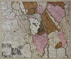
Nicolaus Visscher17th Century Dutch Map of the Holy Land at the Time of Jesus by Visscher, 1663
$1,275
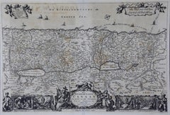
17th Century Dutch Map of the Holy Land at the Time of Jesus by Visscher
By Nicolaus Visscher
Located in Alamo, CA
This detailed Dutch map entitled "Het Beloofe de Landt Canaan door wandelt van onsen Salichmaecker Iesu Christo, nessens syne Apostelen" by Nicolaes Visscher (1610-1679), published i...
Category
1660s Nicolaus Visscher Art
Materials
Engraving