Rigobert Bonne
to
3
3
3
3
3
3
3
3
2
10,589
3,927
2,503
2,241
Creator: Rigobert Bonne
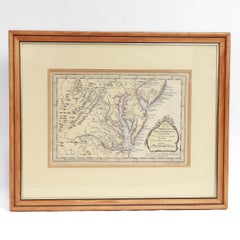
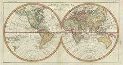
Very Decorative Original Antique Map of the World, Published in France in c.1780
By Rigobert Bonne
Located in Langweer, NL
Antique map titled 'L'Ancien Monde Et Le Nouveau en Deux Hemispheres' - Double hemisphere map of the World, showing the contemporary geographical...
Category
18th Century Antique Rigobert Bonne
Materials
Paper
$736 Sale Price
20% Off
Antique Map of the West Coast of Africa, 1771
By Rigobert Bonne
Located in Langweer, NL
Antique map titled 'Carte de la Guinee contenant les Isles du Cap Verd, le Senegal, la Cote de Guinee proprement dite, les Royaumes de Loango, Congo, Angola, et Benguela avec les Pay...
Category
18th Century Antique Rigobert Bonne
Materials
Paper
$334 Sale Price
20% Off
Antique Map of the Empire of China by Bonne, c.1780
By Rigobert Bonne
Located in Langweer, NL
Antique map titled 'Carte de L'Empire de la Chine.' Decorative map of the Empire of China, depicting China, Corea ( Korea ), Japan, Tonquin and the Philippine island Lucon. Source un...
Category
18th Century Antique Rigobert Bonne
Materials
Paper
$621 Sale Price
20% Off
Related Items
Original Antique Map of The London Underground. 1911
Located in St Annes, Lancashire
Superb map of The London Underground
Published by Ward Lock, 1911
Folding map. Printed on paper
Unframed.
Good condition/ Minor repair to an edge tear on right edge ( shown in ...
Category
1910s English Vintage Rigobert Bonne
Materials
Canvas, Paper
Original Antique Map of The World by Dower, circa 1835
Located in St Annes, Lancashire
Nice map of the World
Drawn and engraved by J.Dower
Published by Orr & Smith. C.1835
Unframed.
Free shipping
Category
1830s English Antique Rigobert Bonne
Materials
Paper
Antique Map of Virginia & the Chesapeake Bay by Jacques-Nicolas Bellin, c. 1750
By Jacques-Nicolas Bellin
Located in Philadelphia, PA
A fine antique 18th century French map of North America.
By Jacques-Nicolas Bellin.
On laid paper with polychrome highlights.
Depicting Virginia, the Chesapeake Bay, and the nearb...
Category
18th Century French Baroque Antique Rigobert Bonne
Materials
Paper
$895
H 15.13 in W 18.63 in D 1.13 in
1812 United States Map, by Pierre Tardieu, Antique French Map Depicting the U.S.
By Pierre François Tardieu
Located in Colorado Springs, CO
1812 "United States of Nth America -- Carte des Etats-Unis De L'Amerique Septentrionale" Two-Sheet Map by Tardieu
This attractive map, published in Paris in 1812, is one of the most rare large format maps from the period. It features a view of the East Coast of the U.S. from Maryland to just below South Carolina. Additionally, Ellicott’s plan for the City of Washington D.C. is included at the top right and an illustration of Niagara Falls is shown at the bottom right with a description in both French and English. This extremely detailed map not only depicts the mountainous regions of the southeastern U.S., but also includes names of regions, rivers, and towns.
Based on the first state of Arrowsmith’s 4-sheet map of the United States, this map is completely engraved by Tardieu in Paris and showcases high quality engravings. This detailed map of the recently independent United States includes one of the largest and earliest examples of the Ellicott plan of Washington DC.
The artist, Pierre François Tardieu (PF Tardieu) was a very well-known map engraver, geographer, and illustrator. Awarded a bronze medal by King Louis-Phillipe for the accuracy and beauty of his map-making, Tardieu produced many fine works including maps of Louisiana...
Category
1810s French Antique Rigobert Bonne
Materials
Paper
$5,750
H 43.5 in W 48 in D 2.25 in
Large Original Vintage Map of The World, circa 1920
Located in St Annes, Lancashire
Great map of The World
Original color.
Good condition / minor foxing
Published by Alexander Gross
Unframed.
Category
1920s English Vintage Rigobert Bonne
Materials
Paper
Gold Leaf Foil Pictorial Plan Map of the West Country of England Antique Style
Located in West Sussex, Pulborough
We are delighted to offer for sale this lovely Antique style pictorial plan map of the West Country of England etched in gold leaf foil
This is a very interesting and decorative p...
Category
20th Century English Adam Style Rigobert Bonne
Materials
Gold Leaf
$263 Sale Price
30% Off
H 15.95 in W 20.08 in D 0.4 in
1771 Choir Gaur; the Grand Orrery of the Ancient Druids
By John Smith
Located in Bath, GB
A scarce first edition of John Smith's study of the prehistorical monument Stonehenge, a early work on the subject, illustrated with three folding plates.
The scarce first edition o...
Category
1770s British Antique Rigobert Bonne
Materials
Paper
Large Original Antique Map of West Virginia, USA, C.1900
Located in St Annes, Lancashire
Fabulous map of West Virginia
Original color
Engraved and printed by the George F. Cram Company, Indianapolis.
Published, C.1900
Unframed
Free shipping.
Category
1890s American Antique Rigobert Bonne
Materials
Paper
Large Original Antique Map of Africa. C.1900
Located in St Annes, Lancashire
Fabulous map of Africa
Original color.
Engraved and printed by the George F. Cram Company, Indianapolis.
Published, C.1900.
Unframed.
Free shipping.
Category
1890s American Antique Rigobert Bonne
Materials
Paper
Original Antique Map of the American State of Kentucky, 1903
Located in St Annes, Lancashire
Antique map of Kentucky
Published By A & C Black. 1903
Original colour
Good condition
Unframed.
Free shipping
Category
Early 1900s English Antique Rigobert Bonne
Materials
Paper
Original Antique Map of the American State of Maine, 1903
Located in St Annes, Lancashire
Antique map of Maine
Published By A & C Black. 1903
Original colour
Good condition
Unframed.
Free shipping
Category
Early 1900s English Antique Rigobert Bonne
Materials
Paper
Original Antique Decorative Map of Iceland & Faroe, Fullarton, C.1870
Located in St Annes, Lancashire
Great map of Iceland and The Faroe Islands
Wonderful figural border
From the celebrated Royal Illustrated Atlas
Lithograph. Original color.
Published by Fullarton, Edinb...
Category
1870s Scottish Antique Rigobert Bonne
Materials
Paper
$140
H 18.5 in W 12.5 in D 0.07 in
Previously Available Items
A Rare French Engraved Map of The Southeastern United States. R.Bonne Circa 1780
By Rigobert Bonne
Located in Charleston, SC
A rare framed French engraved map on paper of the southeastern United States including Virginia, North Carolina, South Carolina, and Georgia. Rigobert Bonne, Paris Circa 1780. Plat...
Category
1780s French Louis XVI Antique Rigobert Bonne
Materials
Paper, Wood
H 16.5 in W 21 in D 1 in
Rigobert Bonne furniture for sale on 1stDibs.
Rigobert Bonne furniture are available for sale on 1stDibs. These distinctive items are frequently made of paper and are designed with extraordinary care. There are many options to choose from in our collection of Rigobert Bonne furniture, although beige editions of this piece are particularly popular. If you’re looking for additional options, many customers also consider furniture by Arnoldus Montanus, Matthäus Merian the Elder, and John Speed. Prices for Rigobert Bonne furniture can differ depending upon size, time period and other attributes — on 1stDibs, these items begin at $388 and can go as high as $701, while a piece like these, on average, fetch $684.