
Theodore R. Davis Art

to
2
1
2
1
1
Overall Height
to
Overall Width
to
1
1
1
1
1
1
2
2
6,886
3,213
2,514
1,217
1
1
Artist: Theodore R. Davis
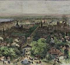
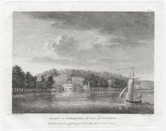
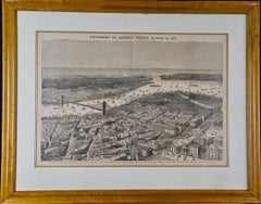
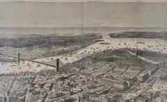
1870 View of Proposed Brooklyn Bridge and New York City
By Theodore R. Davis
Located in Alamo, CA
This framed engraving entitled "Birds-eye View of the Southern End of New York and Brooklyn, Showing the Projected Suspension-Bridge Over the East River, From the Western Terminus in Printing-House Square, New York" by Theodore R. Davis (1840–1894) was published as a supplement of Harper's Weekly, November 19, 1870. The print is presented in a maple frame and a double mat. The frame measures 23.5" high, 29" wide and 0.75" deep. There is a vertical center fold and additional vertical lines, where wood engraving blocks were joined for the printing process. It is in excellent condition. This framed image depicting New York in 1870 was a centerfold for the November 19, 1870 issue of Harper's Weekly. It includes the site and eventual appearance of the East River New York-Brooklyn Bridge; the name later shortened to the Brooklyn Bridge. The print was issued eleven months after the start of construction of the bridge on January 2, 1870, which would take another 12.5 years to complete. When this view was drawn, work on the bridge was all below ground, constructing the supports for the bridge’s towers. Labels in the upper portion of the print identify locations in the background including "Light Ship...
Category

Late 19th Century Naturalistic Theodore R. Davis Art

Materials

Woodcut

"View of the City of Milwaukee" Wood Engraving Hand Colored by Theodore R. Davis
By Theodore R. Davis
Located in Milwaukee, WI
"View of the City of Milwaukee" from "Harper's Weekly" is an original hand-colored wood engraving by Theodore R. Davis. It depicts an aerial view of the Wisconsin lakeside city in 1882. 9" x 13 3/8" art 17 5/8" x 21 3/4" frame Theodore R. Davis (1840–1894) was a 19th-century American artist, who made numerous drawings of significant military and political events during the American Civil War and its aftermath. As a child, Theodore R. Davis was taken to Washington D.C. where he graduated from Rittenhouse Academy. When he was fifteen, he moved to New York where studied art under Henry W. Herrick and James Walker. The Training Theodore Davis received under James Walker was informal. Davis typified certain artists as "special artists" was hired by popular magazines and newspapers. He was hired by them to illustrate the Civil War. He was hired by Harpers Weekly in 1861.[ During the Civil War, he served as a captain in the 15th Connecticut Volunteer Infantry. After the war, he became a companion of the New York Commandery of the Military Order of the Loyal Legion of the United States. Some of these drawings include the Battle of Champion Hill, and the most significant sketch of General Joseph E. Johnston and General William T. Sherman meeting at the Bennett Farm near Durham Station to discuss the surrender terms of the remaining Confederate armies in the Southeast. After the war when the Cyclorama in Atlanta was being painted, Davis was asked for his ideas having traveled with Sherman's army. He was later added to the painting. Theodore Davis was a staff artist at Harper's Weekly. Many of his drawings were published as wood engravings in Harper's Weekly. Theodore R. Davis was chosen to create the Haye's China with a chance meeting. Mr. Davis suggested using flora and fauna of the American decor...
Category

1880s Other Art Style Theodore R. Davis Art

Materials

Engraving

Related Items
Dense Rolling Clouds, Blue Sky Landscape Triptych, Handmade Cyanotype on Paper
By Kind of Cyan
Located in Barcelona, ES
This is an exclusive handprinted limited edition cyanotype of gorgeous rolling clouds. Details: + Title: Dense Rolling Clouds + Year: 2024 + Edition Size: 100 + Stamped and Certifi...
Category

2010s Naturalistic Theodore R. Davis Art

Materials

Photographic Film, Emulsion, Watercolor, Photographic Paper, C Print, Co...

The Fighting Temeraire: A Framed 19th C. Engraving After J. M. W. Turner
By J.M.W. Turner
Located in Alamo, CA
This beautiful 19th century framed engraving "The Fighting Temeraire" by James Tibbetts Willmore is based on an original painting by the renowned British artist J.M.W. Turner. It was published by James S. Virtue & Co. in London between 1859-1875. It depicts the once mighty British warship the HMS Temeraire being towed away down the river Thames by a much smaller steamboat to a ship-breaking yard to be broken up for scrap. The Temeraire was first launched in 1798 and represented the pinnacle of British ship-building. 180-feet long, constructed of English oak and armed with 98 guns, she was one of the largest warships of the period. The Temeraire became a symbol of British pride and military power that endured throughout the 19th century. The man-of-war served during the French Revolutionary and Napoleonic Wars and was among the last serving ships to have been at the Battle of Trafalgar in 1805. It became one of the many older ships put out of service in the 1830s and 1840s. The once mighty and feared ship symbolizes a once magnificent, but now obsolete, technology. Turner seems to lament her inglorious final journey, being towed by a less magnificent, but modern steam powered tugboat. The Turner painting was created in 1838 and is now held in the National Gallery in London. Willmore's engraving, created in 1859, captures the dramatic scene with great detail and skill. The image has become an iconic representation of the decline of Britain's naval power and the transition from sail to steam in the 19th century. The sunset in the background is symbolic of the sun going down on British naval power and tradition. The painting conveys profound and diverse themes that are central to the human experience: those of mortality and change, technology and progress, heroism and brutality. The painting demonstrates Turner’s skill as an artist. His ability to produce scenes of great beauty that are dramatic, but are also symbolic, stimulating both thoughtful analysis, as well as emotion. Turner's painting was voted by the British public in a 2005 BBC radio sponsored survey to be the British people's favorite painting of all time. In 2020 it was included on a new British banknote...
Category

Mid-19th Century Romantic Theodore R. Davis Art

Materials

Engraving

Koichi Sakamoto ( 1932 ) Thatched Cottages - Mezzotinto Etching , 11/80 - Japan
By Koichi Sakamoto
Located in Meinisberg, CH
Koichi Sakamoto (Japanese, 1932) Thatched Cottages with Mountains beyond • Mezzotinto etching, sheet ca. 35 x 55 cm • Plate ca. 20 x 39.5 cm • Signed bottom right • Edition 11/80 (...
Category

Mid-20th Century Naturalistic Theodore R. Davis Art

Materials

Pigment, Paper

View of Emden, Germany: A 16th Century Hand-colored Map by Braun & Hogenberg
By Franz Hogenberg
Located in Alamo, CA
This is a 16th century original hand-colored copperplate engraved map of a bird's-eye View of Embden, Germany entitled " Emuda, vulgo Embden vrbs Frisia orientalis primaria" by Georg Braun & Franz Hogenberg, in volume II of their famous city atlas "Civitates Orbis Terrarum", published in Cologne, Germany in 1575. This is a beautifully colored and detailed map of Emden, a seaport in northwestern Germany, along the Ems River and perhaps portions of over Dollart Bay, near the border with the Netherland. The map depicts a bird's-eye view of the city from the southwest, as well as a view of the harbor and an extensive system of canals. Numerous ships of various sizes, as well as two rowboats containing numerous occupants are seen in the main waterway in the foreground and additional boats line two canals in the center of the city. Two men and two women are shown on a hill in the foreground on the right, dressed in the 16th century style of nobility. Two ornate crests are included in each corner. A title strap-work cartouche is in the upper center with the title in Latin. The crest on the right including Engelke up de Muer (The Little Angel on the Wall) was granted by Emperor Maximilian I in 1495. This is an English translation of an excerpt of Braun's description of Embden: "In Emden, the capital of East Frisia, rich merchants live in very fine houses. The city has a broad and well-situated harbour, which in my opinion is unique in Holland. Frisia and the whole of the Netherlands, for the ships can anchor here right under the city walls. They have also extended the harbour as far as the New Town, so that up to 400 ships can now find shelter here when the sea is rough." The emphasis on the harbor and waterways within the city highlights the importance of Emden's place as a seaport at this time. Embden developed from a Dutch/Flemish trading settlement in the 7th-8th centuries into a city as late as late 14th century. In 1494 it was granted staple rights, and in 1536 the harbour was extended. In the mid-16th century Emden's port was thought to have the most ships in Europe. Its population then was about 5,000, rising to 15,000 by the end of the 16th century. The Ems River flowed directly under the city walls, but its course was changed in the 17th century by the construction of a canal. Emden has canals within its city limits, a typical feature of Dutch towns, which also enabled the extension of the harbor. In 1744 Emden was annexed by Prussia and is now part of Germany. It was captured by French forces in 1757 during the Seven Years' War, but recaptured by Anglo-German forces in 1758. During the Napoleonic French era, Emden and the surrounding lands of East Frisia were part of the short-lived Kingdom of Holland. References:Van der Krogt 4, 1230, State 2; Taschen, Braun and Hogenberg...
Category

16th Century Old Masters Theodore R. Davis Art

Materials

Engraving

The Wedding Procession - Le Cortege nuptial - 17thC Etching from Les Pastorales
By Claudine Bouzonnet-Stella
Located in Meinisberg, CH
Engraved by Claudine Bouzonnet-Stella (French, 1636-1697) After Jacques Stella (French 1596-1657) The Wedding Procession - Le Cortege nuptial • Copper engraving on laid paper • Sh...
Category

17th Century Naturalistic Theodore R. Davis Art

Materials

Laid Paper, Etching, Ink

St. Michael's Mount, Cornwall: A Framed 19th C. Engraving After Myles Foster
By Myles Birket Foster
Located in Alamo, CA
This beautiful 19th century framed hand-colored engraving is entitled "St. Michael's Mount, Cornwall" by J. Saddler after an original painting by the British artist Myles Birket Fost...
Category

Mid-19th Century Romantic Theodore R. Davis Art

Materials

Engraving

Ulysses Deriding Polyphemus: A Framed 19th C. Engraving After J. M. W. Turner
By J.M.W. Turner
Located in Alamo, CA
This beautiful 19th century framed hand-colored engraving/etching entitled "Ullyses Deriding Polyphemus" by Edward Goodall is based on an original 1829 painting by the renowned Briti...
Category

Mid-19th Century Romantic Theodore R. Davis Art

Materials

Engraving, Etching

View of Pisaro, Italy: A 16th Century Hand-colored Map by Braun & Hogenberg
By Franz Hogenberg
Located in Alamo, CA
This is a 16th century original hand-colored copperplate engraved map of View of Pezaro (Pisaro), Italy entitled "Pisaurum vulgo Pezaro" by Georg Braun & Franz Hogenberg, from their famous city atlas "Civitates Orbis Terrarum", published in Augsberg, Germany in 1575. The map depicts a view of Pesaro, Italy from the west looking over the town to the Adriatic Sea. The River Foglia flows into the Adriatic in the foreground. The only identifiable building is the cathedral of San Domenico, which rises above the other roofs with its tall spire. Two women, dressed in styles of the 16th century are in conversation on a hill in the foreground on the left. Pesaro is in the province of Pesaro and Urbino and lies on the Adriatic and east of Florence. The city, which was founded by the Etruscans and named Pisaurum by the Romans, belonged from AD 754 onwards to the Papal States, and after 1285 was controlled by the princely families of Malatesta, Sforza and della Rovere. Today it is the capital of the province of Pesaro and Urbino and has a population of about 92,000. Pesaro's most famous resident, composer Gioacchino Rossini, was born here in 1792. The following is an English translation of an excerpt from Braun's description of the city: "We believe that the astonishingly short life of the inhabitants of Pesaro comes not only from the insalubrious air, but also from the great quantity of delectable and delicious fruits which they consume to excess. For this causes the production in their bodies of evil humours, which then lead to incurably fatal diseases. The area around the city is most charming and well planted with vineyards, fig trees, olive trees and other fruit-bearing trees." 
  References: Van der Krogt 4, 3369, state 1; Taschen, Braun and Hogenberg...
Category

16th Century Old Masters Theodore R. Davis Art

Materials

Engraving

Stow Wengenroth, Friendly Neighbors (Birds)
By Stow Wengenroth
Located in New York, NY
Edition of 80. Signed and numbered in pencil. Really, no one could draw on a lithographic stone like Stow Wengenroth. He drew many animals and birds...
Category

Mid-20th Century Naturalistic Theodore R. Davis Art

Materials

Lithograph

Mountebank - XXI Century, Contemporary Figurative DryPoint Etching Print
By Czeslaw Tumielewicz
Located in Warsaw, PL
Polish painter and graphic designer, Czeslaw Tumielewicz was born in 1942. In 1968, he studied at the Architecture faculty of Gdank, before continuing his course at the Technical Un...
Category

2010s Contemporary Theodore R. Davis Art

Materials

Paper, Etching, Drypoint

A View of Scarborough, England: A Framed 19th C. Engraving After J. M. W. Turner
By J.M.W. Turner
Located in Alamo, CA
This beautiful 19th century framed engraving "Scarborough" by W. Chapman is based on an original painting by the renowned British artist J.M.W. Turner. It was published in London by ...
Category

Mid-19th Century Romantic Theodore R. Davis Art

Materials

Engraving

View of Seravalle, Italy: A 16th Century Hand-colored Map by Braun & Hogenberg
By Franz Hogenberg
Located in Alamo, CA
This is an original 16th century copperplate originally hand-colored engraved map of View of Seravalle, Italy entitled "Seravallum Celeberrimum Marchiae Tarvisiniae in Agro Foro Juliensi Opp. - Seravalli, quam vides, Spectator, iconem, operi huic nostro suis sumptib. . . ." by Georg Braun & Franz Hogenberg, from their famous city atlas "Civitates Orbis Terrarum", published in Augsberg, Germany in 1575. The map depicts a view of Seravalle, now Vittorio Veneto, in San Marino, Italy, north of Venice, in a topographically accurate bird's-eye view from the south. A water-filled moat is seen to the south of the city walls and farmland to the east. Two men are depicted standing on a hill in the lower right in conversation next to grain sacks and a grazing horse, while a younger man behind them to the right herds a mule carrying presumably pigs. A very colorful and ornate title cartouche is in the upper center and coat-of-arms are in the right and left upper corners. Serravalle lies in an idyllic setting in the foothills and surrounded by orchards. St Mary's Cathedral with its tall bell tower is prominent in the center of the town. The marketplace and town hall with a bell tower in the square are depicted. Houses and shops are around the main square. Serravalle's importance as an agricultural centre is emphasized by the figures in the foreground. In 1337 Serravalle was conquered by the Republic of Venice. In 1866 the town was united with neighbouring Ceneda to form the town of Vittorio Veneto. The following is an English translation of an excerpt from the French description of the city on the back of the map: "Serravalle, a market town renowned for cloth, wine and grain, is in such a beautiful situation that the number of its inhabitants, attracted by the loveliness of the place, has grown so much at times that the wall encircling it has had to be enlarged for the third time. The city with the surrounding town once belonged to the Church in Ceneda as an imperial fief. It subsequently became the seat of the Da Camino family (a princely house that at that time was one of the five most noble in all Italy). Now the city is under the sway of the Venetians but is prudently governed by them. For they send only one city councillor with instructions to ensure that justice prevails and to collect duties. In all else, power lies in the hands of the noble families." This is a translation of the Latin in the title cartouche on the front: "The picture of the town of Serravalle, which you see, viewer, has been contributed to our work entirely at his own expense by Minutius, son of Hieronymus Minutius, a noble gentleman and one renowned for the far-reaching competence of his jurisdiction. We saw him sojourning in Cologne, where he was on business for Gregory XIII; while our good wishes accompany him, we should also like to accompany him on his way with this remembrance, even though it might be against his will, so that even those who have not seen him may learn of his excellence. However, those who do not yet know him will also see his excellence if God the Almighthy does not summon erring souls too soon back to the eternal seat of the Blessed." References: Van der Krogt 4, 4728, State 1; Taschen, Braun and Hogenberg, p.331; Fauser, #14960 This striking hand-colored city view is printed on laid, chain-linked paper with wide margins. The sheet measures 16" high by 21" wide. There is a central vertical fold as issued and French text on the verso, with Latin on the front. There is some discoloration in the upper and right margins which may represent some watercolor paint from the time of the original hand-coloring of the map. There is a small hole to the right of the upper portion of the vertical fold, which is only visible when held up to light and an area of reinforcement on the verso of the lower vertical fold. The map is otherwise in very good to excellent condition. Braun and Hogenberg's 'The Civitates Orbis Terrarum' was the second atlas of maps ever published and the first atlas of cities and towns of the world. It is one of the most important books published in the 16th century. Most of the maps in the atlas were engraved by Franz Hogenberg and the text, with its descriptions of the history and additional factual information of the cities, was written by a team of writers and edited by Georg Braun. The work contained 546 bird-eye views and map views of cities and towns from all over the world. It gave graphic representation of the main features of the illustrated cities and towns, including the buildings and streets. Although the ordinary buildings are stylized, the principal buildings are reproduced from actual drawings created on location. The principal landmarks and streets can still be recognized today. In addition, the maps often include the heraldic arms of the city, the nature of the surrounding countryside, the important rivers, streams and harbors, even depicting stone bridges, wooden pontoons, flat-bottomed ferries, ships and working boats, wharves and jetties, as well as land-based activities, including horsemen, pedestrians, wagons, coaches, and palanquins. Small vignettes are often included which illustrate the trade, occupations and habits of the local inhabitants, such as agriculture, paper-making and textiles, as well as local forms of punishment, such as gibbets, wheels, floggings etc. Large figures dressed in their local costume are often presented out of proportion in the foreground. The aim of the authors was to give as much information as possible in a pleasing visual form. They succeeded in creating maps that were both informative and decorative works of art. The atlas is a wonderful glimpse of life in medieval Europe. Georg Braun (1541-1622) was German Catholic...
Category

16th Century Old Masters Theodore R. Davis Art

Materials

Engraving

Theodore R. Davis art for sale on 1stDibs.

Find a wide variety of authentic Theodore R. Davis art available for sale on 1stDibs. You can also browse by medium to find art by Theodore R. Davis in engraving, woodcut print and more. Not every interior allows for large Theodore R. Davis art, so small editions measuring 22 inches across are available. Customers who are interested in this artist might also find the work of William Curtis, Paul-Adolphe Rajon, and Paul Sandby. Theodore R. Davis art prices can differ depending upon medium, time period and other attributes. On 1stDibs, the price for these items starts at $460 and tops out at $950, while the average work can sell for $705.

Artists Similar to Theodore R. Davis

Recently Viewed

View All