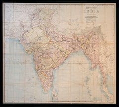
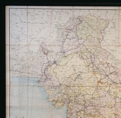
Railway Map of India.
Located in London, London
THUILLIER, Colonel Henry Ravenshaw.
Railway Map of India. Railways Brought up to October 1895. Scale 1 Inch = 48 miles or 1:3,041,280.
[Calcutta], Published under the direction of Colonel H. Thuillier, R.E., Surveyor General of India, October 1890.
A comprehensive railway map of British India, including the subcontinent and Burma, also displaying the main road networks, navigable canals, steamship routes, and telegraph connections across the peninsular. This publication by the Survey of India Office includes a useful ‘References’ key giving information on the differing gauges in use across the region, and a colour code highlighting the lands under direct British administration in pink, ‘Tributary States’ in yellow and ‘Independent & Foreign Possessions’ in Green. A notice records the price for colour as ‘Five Rupees’, as against ‘Four Rupees’ without.
Prepared under the direction of Colonel Henry Ravenshaw Thuillier, who as his father before him, served as Surveyor General of India from 1887 to 1895. Here Baluchistan is shown as an enclave of the British Raj. This strategically important territory lies in modern-day Pakistan, and is situated around the natural fort town of Quetta located high in the Chiltan mountains. It came under direct British rule in 1876, securing the vital Bolan Pass though which British troops under the command of General Michael Biddulph passed during the Second Anglo-Afghan War...
Category
1890s Other Art Style Unknown More Art