Collectibles and Curiosities on Sale

to
5,462
1,390
6,860
43
42
353
168
91
80
66
50
41
40
35
27
24
17
15
10
8
7
5
3
2,707
2,346
1,807
85
540
699
288
113
30
79
124
69
147
129
89
64
29
4,950
1,190
604
280
236
1,280
505
456
278
260
6,945
6,941
6,941
104
55
21
18
13
Sale Items
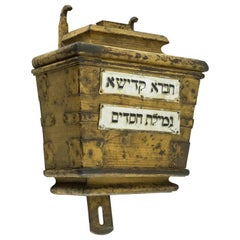
19th Century Hungarian Synagogue Iron Charity Container
Located in New York, NY
Large handmade iron charity container, Hungary, circa 1850. The iron tzedakah box was installed within the wall at the Hungarian Synagogue. On the fr...
Category

Antique Mid-19th Century Hungarian Religious Items

Materials

Iron

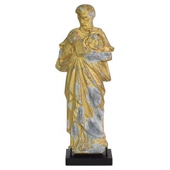
French Late 19th Century Neo Gothic Gilded Metal Saint Statue
Located in Buisson, FR
Wonderful gilded metal saint statue with beautiful expression, France, circa 1880-1900. Weathered. Measurements include the wooden base.
Category

Antique Late 19th Century French Gothic Revival Religious Items

Materials

Metal

Charming Vintage Porcelain Doll - 42cm, 20th Century, Pretty in Pink- 2C01
Located in Bordeaux, FR
Embrace the enchantment of a bygone era with our Vintage Porcelain Doll. Standing gracefully at 42cm x 16cm x 6cm, this lovely doll captures the essence of the 20th century in every delicate detail. Dressed in a delightful pink ensemble, she exudes a timeless charm that adds a touch of nostalgia to any collection. Crafted with care and preserved in good condition, this porcelain doll is a testament to the enduring beauty of quality craftsmanship. Her expressive features and elegant posture make her a captivating addition to your cherished possessions. Whether you're a doll collector...
Category

20th Century Toys and Dolls

Materials

Porcelain

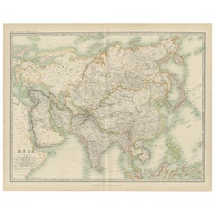
Antique Map of Asia by Johnston '1909'
Located in Langweer, NL
Antique map titled 'Asia'. Depicting China, Japan, Indonesia, India, Arabia and more. This map originates from the ‘Royal Atlas of Modern Geography’. Published by W. & A.K. Johnston,...
Category

Early 20th Century Maps

Materials

Paper

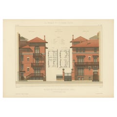
Maison Rue de la Faisanderie – French Architectural Print from La Brique, c.1900
Located in Langweer, NL
Maison Rue de la Faisanderie – French Architectural Print from La Brique, c.1900 This antique architectural print showcases an elegant townhouse designed for the Rue de la Faisander...
Category

20th Century French Prints

Materials

Paper

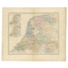
Antique Map of the Netherlands in 1808 by Mees, 1857
Located in Langweer, NL
Antique map titled 'Noord-Nederland in 1808. Het Koningrijk Holland na het tractaat van Fontainebleau van 11 november 1807'. Map of the Netherlands in 1808. This map originates from ...
Category

Antique 19th Century Maps

Materials

Paper

Early Original Antique Map of South East Asia with Large Parts Still Unknown
Located in Langweer, NL
Antique map titled 'Insulae Indiae Orientalis'. Original antique map of Southeast Asia. Shows towns, villages, landmarks, mountains, and rivers. Relief shown pictorially. This map or...
Category

Antique Late 17th Century Maps

Materials

Paper

Newfoundland and St. Pierre & Miquelon: Uncoloured French Map of circa 1820
Located in Langweer, NL
The map is titled "Île et Banc de Terre-Neuve avec les Îles St. Pierre et Miquelon", depicting Newfoundland and the French islands of St. Pierre and Miquelon. It is from the Petit Atlas National series. Features: - The map is divided into two sections: 1. The left side shows Newfoundland (Terre-Neuve) and its surrounding waters, including important locations such as the Île du Cap Breton and Grand Bank fishing areas. 2. The right side focuses on St. Pierre and Miquelon, a French overseas territory near Newfoundland. - Administrative divisions and key geographic features, such as capes, bays, and towns, are labeled on the map. Historical Context: - This map is part of a collection meant to showcase France's overseas colonies and territories, including the small but significant St. Pierre and Miquelon, which has been under French control for centuries and was a critical fishing and trading hub. - The Petit Atlas National series was typically published in the early 19th century, and this map likely dates from the same period, around 1815–1820. Here the text transalated: Here is the translation of the text from French to English: --- **NOTICE.** The islands of St. Pierre and Miquelon, the only remaining French possession in this part of America since the loss of Canada, are located a few miles from the southern coast of Newfoundland, which belongs to the English. Their relatively fertile soil is broken up by hills that give rise to small streams. **Grande Miquelon**, the northernmost of the two islands, has a circumference of about 9 to 10 leagues. It offers a convenient port for fishing boats. **Petite Miquelon**, to the south of Grande Miquelon, has a circumference of about 6 leagues. It is well-watered and well-wooded. **Saint Pierre**, to the south-southwest of the two other islands, presents a somewhat similar appearance but is devoid of trees. Although it is the smallest of the three islands, it is the most important due to the size of its harbor, which can accommodate 30 to 40 ships of various sizes, and because of its favorable coastline for the preparation, preservation, and export of cod. On its eastern coast, at the bottom of a beautiful bay, lies the town of Saint Pierre, the only notable settlement on the three islands. It is the residence of a naval officer who, under the title of Commander, governs the colony. The permanent population is about 2,000 souls, of which 800 reside in Saint Pierre. However, sailors come to the islands from the coasts of Brittany and Normandy during the cod fishing season on the Grand Banks of Newfoundland and the Gulf of St. Lawrence. In 1833, it was estimated that about 14,000 sailors were employed in this fishery, and the purchase of supplies required by the colony was valued at over one million francs. --- This translation reflects the original notice describing the French islands of St. Pierre and Miquelon, with details about their geography, population, and economic activities related to the fishing industry. People searching for maps or information about Newfoundland and the French islands of St. Pierre and Miquelon use the following keywords: 1. Newfoundland map...
Category

Antique 1820s Maps

Materials

Paper

Extremely Rare Map of The land of Eso or Hokkaido in Japan, 1725
Located in Langweer, NL
Plate 46: 'Le Pais d' Eso.' (The land of Eso / Hokkaido in Japan.) Extremely rare in this edition. This plate originates from the very scarse: 'La Galerie Agreable du Monde (..). T...
Category

Antique 18th Century Maps

Materials

Paper

L'isle De La Martinique Caribbean Copper Engraving Original Handcoloring, 1704
Located in Langweer, NL
The original hand-colored map titled "Isle de la Martinique," published in 1704 and part of De Fer's Atlas Curieux, is a cartographic masterpiece offering an intricate portrayal of t...
Category

Antique Late 19th Century Maps

Materials

Paper

Antique Print with Views of Sir Charles Saunders Island and Other Islands, 1774
Located in Langweer, NL
Explore the captivating world of the 18th century with this exquisite antique print titled 'Isles de Sir Charles Saunder Latitude (...)'. I A journey through time as you delve into t...
Category

Antique Late 18th Century Maps

Materials

Paper

Antique Map of the Holy Land, showing the travels of Abraham, Isaac and Jacob
Located in Langweer, NL
Antique map titled 'Tabula Itineraria Patriarcharum Abrahami, Isaaci et Iacobi'. Decorative regional map of the Holy Land, showing the travels of Abraham, Isaac and Jacob. Published ...
Category

Antique Mid-17th Century Maps

Materials

Paper

Original Antique Map of England with Decorative Cartouche
Located in Langweer, NL
Antique map titled 'l'Angleterre (..)'. Original antique map of England, with beautiful hand coloring and decorative cartouche. This map originates from 'Nouvel Atlas Portatif destin...
Category

Antique Late 18th Century Maps

Materials

Paper

Antique Map with Details of Berings' Expedition into Russians' Far East, 1737
Located in Langweer, NL
Antique map titled 'Carte Des Pays traverses par le Capne. Beerings depuis la Ville de Tobolsk jusqua'a Kamtschatka'. This is the first printed map to illustrate Vitus Bering's fir...
Category

Antique 1730s Maps

Materials

Paper

Historical Map of Northern Europe and Russia - Engraved for I. Harrison, 1788
Located in Langweer, NL
Historical Map of Northern Europe and Russia - Engraved for I. Harrison, 1788 This impressive historical map titled A New Map of Europe Containing Denmark, Norway, Sweden and Russ...
Category

Antique 1780s Maps

Materials

Paper

Antique Map of Holstein, Germany
Located in Langweer, NL
Antique map titled 'Holsatia Ducatus'. Original old map of Holstein, Germany. By Petrus Kaerius, published circa 1650. Pieter van den Keere (Latin: Petrus Kaerius 1571 – circa 1646) ...
Category

Antique Mid-17th Century Maps

Materials

Paper

Antique Map of Holstein, Germany
$362 Sale Price
20% Off
Original Antique Map Covering the Russian Empire in Asia, 1880
Located in Langweer, NL
Antique map titled 'Sibérie ou Russie d'Asie'. Migeon's map covers the Russian empire in Asia from european Russia and the Ural Mountains to the Bering Strait and from the Arctic...
Category

Antique 1880s Maps

Materials

Paper

Scandinavian Amber Pendant And Sterling Silver Necklace
Located in Haddonfield, NJ
Amber pendant in a sterling silver setting with a Italian 925 silver chain.
Category

Mid-20th Century Danish Scandinavian Modern Collectible Jewelry

Materials

Sterling Silver

Antique Plan of Turkey in Europe with Inset Map of the Bosporus, ca.1850
Located in Langweer, NL
Antique map titled 'Turkey in Europe'. A map of European Turkey and the surrounding countries. With an inset map of the Bosporus. This includes Macedonia, Bulgaria, Croatia, Bosn...
Category

Antique 1850s Maps

Materials

Paper

Antique Map of Ukraine, Bulgaria, Romania, Servia & Surroundings by N. Visscher
Located in Langweer, NL
Antique map titled 'Exactissima Tabula qua tam Danubii Fluvii Pars Inferior, a Belgrado Urbe usq ad ejus ostia, et minores in eum influentes, Fluvii quam Regiones adjacentes, ut Tran...
Category

Antique Early 18th Century Maps

Materials

Paper

Antique Map of the Palembang Area, c.1900
Located in Langweer, NL
Antique map titled 'Palembang.' This map shows the Palembang area on the Indonesian island of Sumatra. With legend. Source unknown, to be determined. Published circa 1900. Artists...
Category

Antique 19th Century Maps

Materials

Paper

Historical Map of the Duchy of Lauenburg by Johann Baptist Homann - Circa 1720
Located in Langweer, NL
Historical Map of the Duchy of Lauenburg by Johann Baptist Homann - Circa 1720 This splendid historical map titled Ducatus Lauemburgicus is a highly detailed and beautifully engra...
Category

Antique 1720s Maps

Materials

Paper

Vintage Ken A Vision Microprojector In Aluminium, 1950s
Located in Zohor, SK
Beautiful vintage microprojector from 1950s. Produced by Ken-A-Vision company. Original labels still attached. The item is in pure aluminium which looks really great. The flowing des...
Category

Vintage 1950s American Mid-Century Modern Scientific Instruments

Materials

Aluminum

Pl. 23 Antique Chart of the US Foreign Parentage in 1870, '1874'
Located in Langweer, NL
Antique chart titled 'Map showing, in five degrees of density, the distribution, within the territory of the United States east of the 100th Meridian, of that portion of the populati...
Category

Antique Late 19th Century Maps

Materials

Paper

14k White Gold Filled Wristband Bracelet Watch by Elaine Switzerland
Located in Van Nuys, CA
Beautiful 16-jewel mechanical manual movement by Elaine with an early Art Deco 14K gold filled watch showcases graceful hand-etched floral and vine motifs. The case and 12-hour dial ...
Category

Vintage 1920s American Art Deco Collectible Jewelry

Materials

Gold

Antique Map of South America with Many Details, ca.1859
Located in Langweer, NL
Original antique map titled 'Süd-America'. Beautiful old map of South America, with many details and legend. This map originates from Stielers Handatlas, published circa 1859. St...
Category

Antique Mid-19th Century Maps

Materials

Paper

Antique Map of the Island of Djerba by Coronelli '1691'
Located in Langweer, NL
Antique map titled 'Isola e Castello di Gerbi'. Original antique map of the Island of Djerba, Tunisia, in Africa. Includes an inset of the Djerba Castle in upper right. This map orig...
Category

Antique Late 17th Century Prints

Materials

Paper

Art Deco Lipstick Holder in Silver, 1930s
Located in Esbjerg, DK
A small lipstick holder in 830/1000 silver. Intricate guilloché around its perimeter. It weights in around 50 gr. and is signed by the maker and Hallma...
Category

Vintage 1930s Art Deco Collectible Jewelry

Materials

Silver

Antique Map of Europe by Keizer & de Lat, 1788
Located in Langweer, NL
Antique map titled 'Kaartje van Europa (..)'. Uncommon original antique map of Europe. This map originates from 'Nieuwe Natuur- Geschied- en Handelkundige Zak- en Reisatlas' by Gerri...
Category

Antique Late 18th Century Maps

Materials

Paper

Antique Map of British Guayana with Insets of Georgetown, Devil's Rock Etc, 1851
Located in Langweer, NL
Antique map titled ‘British Guayana’. Includes decorative vignettes titled Georgetown, Christmas Cataract River Berbice, New Amsterdam and Ataraipu or the Devil’s Rock. Originates fr...
Category

Antique 19th Century Maps

Materials

Paper

Badajoz 1901: A Cartographic Record of Extremadura's Largest Province in Spain
Located in Langweer, NL
This original antique map for sale is of the province of Badajoz, part of the autonomous community of Extremadura in Spain, dated 1901. It illustrates several important features: Th...
Category

Antique Early 1900s Maps

Materials

Paper

Antique Panoramic View of the Town of Malacca, Malaysia, 1726
Located in Langweer, NL
Antique print Malaysia titled 'De Stad Malacka'. Decorative panoramic view of the town of Malacca with European vessels in the foreground. The old C...
Category

Antique 1720s Maps

Materials

Paper

Print of Mourning of Greek Widows in Rama and Baptism in The River Jordan, 1730
Located in Langweer, NL
Description: Antique print titled 'Deuil des Femmes Greques a Rama' and 'Bapteme des Grecs dans le Jourdain'. The upper image depicts Mourning Greek widows in Rama, the lower ima...
Category

Antique 1730s Religious Items

Materials

Paper

Antique Map of Overijssel by Bachiene, 1758
Located in Langweer, NL
Antique map titled 'Over-Yssel'. Map of the Overijssel, the Netherlands. This map originates from 'Kort begrip der Oude en Nieuwe Staatkundige Geographie', by W.A. Bachiene, publishe...
Category

Antique 18th Century Maps

Materials

Paper

Antique Print of the Jewish Feast or Commemoration of the Passover, 1725
Located in Langweer, NL
Description: Antique print titled 'Het Pascha der Jooden'. Print of the Jewish Pesach / Passover. Pascha, Passover, Hebrew Pesa? or Pesach, in Judaism, holiday commemorating the ...
Category

Antique 1720s Prints

Materials

Paper

Niels Erik From Modernist Silver Pendant Necklace & Earrings, 1970s
By Niels Erik From
Located in Esbjerg, DK
A late 1960s or early 1970s pendant necklace with matching earrings/ear-clips by Danish silversmith N. E. From. The set exhibits a delicate texture/polish to its abstract shapes. The pendant comes with its original 40 cm integrated Bismarck necklace...
Category

Vintage 1970s Danish Mid-Century Modern Collectible Jewelry

Materials

Agate, Sterling Silver

Antique Print of a Stove Chimney, 1766
Located in Langweer, NL
Antique print titled 'A new invented Stove Chimney'. Print of various elements of a new invented stove chimney. This print originates from 'The Gentleman's Magazine'. Artists and Eng...
Category

Antique 18th Century Prints

Materials

Paper

Map of India and Ceylon with Inset of Calcutta and the Ganges, by Bonne, 1780
Located in Langweer, NL
The map on offer is an antique copperplate engraving of India and Ceylon (Sri Lanka), created by Rigobert Bonne (1727-1794), a prominent French cartographer. Here is a breakdown of t...
Category

Antique 1780s Maps

Materials

Paper

Antique Map of the Provinces of Gelderland and Overijssel by Kaerius, 1617
Located in Langweer, NL
Antique map titled 'Geldria et Transysulana'. Scarse map by Kaerius of the provinces Gelderland and Overijssel in the Netherlands. Large cartouche with coat of arms and sailing ship ...
Category

Antique 17th Century Maps

Materials

Paper

Antique Map of Eastern Russia in Asia by Kuyper, 1880
Located in Langweer, NL
Antique map titled 'Aziatisch Rusland. Oost'. Original antique map of Eastern Russia in Asia. This lithographed map originates from: 'Wereld-atlas voor ...
Category

Antique 19th Century Maps

Materials

Paper

Hammered Metal Mid-Century Modern Infinity Pendant Necklace with Drop, Vintage
Located in Warrenton, OR
Hammered Metal Mid-Century Modern Infinity Pendant Necklace with Drop, Vintage/MCM This is a beautiful, hammered gold (tone) metal pendant, a great statement necklace, with a pretty ...
Category

Mid-20th Century Unknown Mid-Century Modern Collectible Jewelry

Materials

Crystal, Metal

Antique Map of Portugal by Moll, 1727
Located in Langweer, NL
Antique map Portugal titled 'Portugal Agreeable to Modern History'. Detailed map of Portugal showing major routes, waterways, arch bishoprics, bis...
Category

Antique 18th Century Maps

Materials

Paper

Antique Map of Italy by Lapie, 1842
Located in Langweer, NL
Antique map titled 'Carte de l'Italie Ancienne'. Map of Italy. This map originates from 'Atlas universel de géographie ancienne et moderne (..)' by Pierre...
Category

Antique Mid-19th Century Maps

Materials

Paper

Antique World Map by Lesage, 1823
Located in Langweer, NL
Antique world map titled 'Mappe Monde Historique'. The map depicts both the Eastern and Western Hemispheres, with the hemispheres meeting in the midd...
Category

Antique Early 19th Century Maps

Materials

Paper

Antique World Map by Lesage, 1823
$286 Sale Price
20% Off
Antique Chinese Tin Toy Chinese MS 705 Trolley Bus Shanghai-Rare, 1950/1960
Located in Amsterdam, Noord Holland
One of the absolute rarest antique Chinese toys made. Antique Red China Tin Toy clockwork. Chinese MS 705 Trolley Bus Shanghai-Rare! Additional informatio...
Category

20th Century Chinese Toys and Dolls

Materials

Porcelain

Antique Map of North America by Dufour 'circa 1834'
Located in Langweer, NL
Antique map titled 'Amérique Septentrionale'. Uncommon map of North America. Published by or after A.H. Dufour, circa 1834. Source unknown, to be determined.
Category

Antique Mid-19th Century Maps

Materials

Paper

Decorative Map of the French Regions of Picardy, Artois & French Flanders, c1780
Located in Langweer, NL
Antique map titled 'Carte des Gouvernements de Flandre Francoise, d'Artois, de Picardie et du Boulenois.' An attractive example of Rigobert Bonne's 1771 decorative map of the Fre...
Category

Antique 1780s Maps

Materials

Paper

Old Map of the Sinai Peninsula Showing the Mediterranean and the Red Sea, 1773
Located in Langweer, NL
Antique map of the Sinai Peninsula showing the Mediterranean Sea to the north and the Red Sea to the south. The map is decorated with images of a Persian wheel and a view of a vi...
Category

Antique 1770s Maps

Materials

Paper

Antique Map of Edom, an Ancient Kingdom in Transjordan, 1773
Located in Langweer, NL
Antique print titled 'Idumea, of thet Land der Philistynen'. Old map of Edom, an ancient kingdom in Transjordan located between Moab to the northeast, the Arabah to the west and the ...
Category

Antique 18th Century Maps

Materials

Paper

Ancient Course of the Ganges: A First Ptolemaic Map of India by Mercator, c.1584
Located in Langweer, NL
This remarkable map, titled "Asiae X Tab:", is a significant historical artifact that represents the convergence of knowledge and craftsmanship from two of the most esteemed figures in the history of geography and cartography. Created by Gerard Mercator and based on the geographical insights of Claudius Ptolemy, this map is part of the rare first issue published in Brussels in 1578. The map itself meticulously delineates the region between the Indus and Ganges rivers, an area of immense historical and geographical importance. It is an excellent representation of Ptolemy's second-century geographical data, which was fundamental in shaping the modern principles of mapmaking. Mercator, renowned for his precision and dedication to adhering closely to Ptolemy's original intentions, showcases this commitment through the detailed depiction of this significant Asian landscape. This edition stands out not only for its historical accuracy but also for its artistic execution. Gerard Mercator, who was also an innovator in the use of the italic hand for map lettering, first introduced this style in his "Literarum latinarum" in 1540. The use of italics in this map enhances its legibility and aesthetic appeal, which became a hallmark of the finest sixteenth and seventeenth-century Dutch maps, largely attributed to Mercator’s influence. The map measures 13 ½ x 18 inches and features fine hand coloring, which has been preserved in almost excellent condition alttough there some browning due to age. As a splendid example of the first issue from Mercator’s definitive edition of Ptolemy’s "Geographia", it not only serves as a testament to the rich history of geographical exploration but also stands as a beacon of the enduring legacy of its makers, shaping the future of cartographic design and precision. The map "Asiae X Tab:", focusing on the region between the Indus and Ganges rivers, highlights several areas and cities of historical and geographical importance that are likely of interest to scholars, historians, and collectors. Here are key locations depicted on the map: 1. **Indus River**: As one of the major rivers of Asia and a cradle of ancient civilizations like the Indus Valley Civilization, the Indus River holds significant historical importance. 2. **Ganges River**: Another crucial river not just for its cultural and religious significance in India, but also as a vital geographic feature in ancient and medieval maps...
Category

Antique 16th Century Maps

Materials

Paper

Antique Print of The Roman Catholic Cathedral in Fribourg, Switzerland, 1860
Located in Langweer, NL
Antique print titled 'Abside de la Cathedrale de Fribourg'. Antique print depicting the Chancel End of Freyburg Cathedral. Fribourg Cathedral (French: Cathédrale Saint-Nicolas de Fribourg) is a Roman Catholic...
Category

Antique 19th Century French Prints

Materials

Paper

Antique Portrait of a Dutch Officer Named Jan Van Swieten 1874
Located in Langweer, NL
Antique portrait titled 'Luitenant Generaal J. van Swieten. Civiel regeerings commissaris en opperbevelhebber der Militaire Operatien tegen Atchin'. Antique portrait of Jan van Swieten. Van Swieten started his career in 1821 as an volunteer and started as a cadet in 1822, in 1824 became a second Lieutenant. Jan van Swieten played an important role as an officer in the Dutch East Indies and led expeditions in Java. Returned to the Netherlands in 1862, and was politically active for some time. In 1873 he was appointed commander of an expedition to Java. He recaptured The Kraton. In 1874 he received the Grand Cross of the Military Order...
Category

Antique 19th Century Prints

Materials

Paper

Antique Handcolored Print of an Afghan from Herat in Afghanistan, 1843
Located in Langweer, NL
Antique costume print titled 'Afghan d'Herat'. Original antique print of an Afghan from Herat. This print originates from 'Moeurs, usages et costumes de tous les peuples du monde' by...
Category

Antique 19th Century Prints

Materials

Paper

Original Antique Map of the English counties Cornwall, Devon, Dorset, etc, 1633
Located in Langweer, NL
Antique map titled 'Cornubia, Devonia, Somersetus, Dorcestria, Wiltonia, Glocestria, Monumetha, Glamorgan, Caermarden, Penbrok, Cardigan, Radnor, Breknoke et Herfordia'. Old map of the English counties of Cornwall, Devon, Somerset, Dorset, Wiltshire, Gloucestershire, Herefordshire, Worcestershire etc. Originates from the 1633 German edition of the Mercator-Hondius Atlas Major, published by Henricus Hondius and Jan Jansson under the title: 'Atlas: das ist Abbildung der gantzen Welt, mit allen darin begriffenen Laendern und Provintzen: sonderlich von Teutschland, Franckreich, Niderland, Ost und West Indien: mit Beschreibung der selben.' Artists and Engravers: Gerard Mercator (1512 - 1594) originally a student of philosophy was one of the most renowned cosmographers and geographers of the 16th century, as well as an accomplished scientific instrument maker. He is most famous for introducing Mercators Projection, a system which allowed navigators to plot the same constant compass bearing on a flat...
Category

Antique 1630s Maps

Materials

Paper

Jacques Adnet, Black Leather Pipes Displayer, French, circa 1950
By Jacques Adnet
Located in Marcq-en-Barœul, Hauts-de-France
This rare black leather pipes displayer has been made by famous French designer Jacques Adnet, circa 1950.
Category

Vintage 1950s French Mid-Century Modern Tobacco Accessories

Materials

Leather

Colorful Italian Silver Pendant Bracelet with Murano Glass Beads
Located in Esbjerg, DK
Colorful double roped bracelet in 925 sterling silver set with 10 Murano beads in Glass and 925 sterling. Made in Italy circa 1990-2000s. Each of the 10 beads are stamped: 925, Italy...
Category

20th Century Italian Modern Collectible Jewelry

Materials

Silver

Old Map of the Black Sea, The Krim, Ukraine, Russia, etc in Historic Times, 1848
Located in Langweer, NL
Antique map titled 'Pontus Euxinus'. Old map of the black Sea and surroundings originating from 'Orbis Terrarum Antiquus in usum Scholarum'. Artists and Engravers: Published by J...
Category

Antique 1840s Maps

Materials

Paper

Vintage School Chart of Coal Mining Operation Plus Cross Section on Verso, 1931
Located in Langweer, NL
Title: De Mijn Maurits bij Sittard (The Maurits Mine near Sittard). On the verso 'Doorsnede van een kolen mijn in Limburg'. Translated: Cross Section of a Coalmine in Limburg (a province in the South of The Netherlands). Sittard is a city in the province of Limburg, in the south of Holland. In 1947 this coal mine was connected to another mine: the Emma Mine, by a 13 km straight tunnel. In the second half of the 1940s and in the 1950s the mine was expanded, and mining reached a depth of 810 m. A third shaft was completed in 1958. At the time of completion of the third shaft, the Maurits mine was the largest two-shafts mine in the world. It was the largest coal mine in the Netherlands. When in the beginning of the 1960s the economic tide for coal mining...
Category

Early 20th Century European Posters

Materials

Other

Engraving of the Deity Quante-Cong 'or Shangdi', First Ruler of China, 1808
Located in Langweer, NL
Antique print titled 'Quantecong, a divinity of the Chinese, which they suppose to have been their first Emperor'. Engraving of the deity Quante-Cong (or Shangdi), first ruler of C...
Category

Antique Early 1800s Prints

Materials

Paper

Antique Map of Java and Madura Island, Indonesia, c.1760
Located in Langweer, NL
Antique map titled 'Idee de l'Isle de Java.' Well engraved and attractive chart of the island shows all principal harbors and coastal details, plus rivers, mountains and volcanoe...
Category

Antique 18th Century Maps

Materials

Paper

Read More

Medal-Worthy Memorabilia from Epic Past Olympic Games

Get into the games! These items celebrate the events, athletes, host countries and sporting spirit.

Ahoy! You’ve Never Seen a Collection of Sailor Art and Kitsch Quite Like This

French trendsetter and serial collector Daniel Rozensztroch tells us about his obsession with objects related to seafaring men.

Pamela Shamshiri Shares the Secrets behind Her First-Ever Book and Its Effortlessly Cool Interiors

The sought-after designer worked with the team at Hoffman Creative to produce a monograph that beautifully showcases some of Studio Shamshiri's most inspiring projects.

Moroccan Artworks and Objects Take Center Stage in an Extraordinary Villa in Tangier

Italian writer and collector Umberto Pasti opens the doors to his remarkable cave of wonders in North Africa.

Montecito Has Drawn Royalty and Celebrities, and These Homes Are Proof of Its Allure

Hollywood A-listers, ex-pat aristocrats and art collectors and style setters of all stripes appreciate the allure of the coastal California hamlet — much on our minds after recent winter floods.

Whaam! Blam! Pow! — a New Book on Pop Art Packs a Punch

Publishing house Assouline and writer Julie Belcove have teamed up to trace the history of the genre, from Roy Lichtenstein, Andy Warhol and Yayoi Kusama to Mickalene Thomas and Jeff Koons.

What Makes a Gem-Encrusted Chess Set Worth $4 Million?

The world’s most opulent chess set, weighing in at 513 carats, is literally fit for a king and queen.

Tauba Auerbach’s Geometric Pop-Up Book Is Mighty Rare, Thanks to a Hurricane

This sculptural art book has an epic backstory of its own.
Recently Viewed

View All