Items Similar to Antique Plan of Turkey in Europe with Inset Map of the Bosporus, ca.1850


Want more images or videos?
Request additional images or videos from the seller
1 of 5
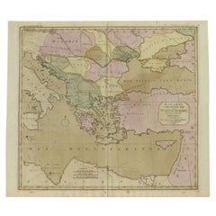
Antique Plan of Turkey in Europe with Inset Map of the Bosporus, ca.1850
About the Item
Antique map titled 'Turkey in Europe'.
A map of European Turkey and the surrounding countries. With an inset map of the Bosporus. This includes Macedonia, Bulgaria, Croatia, Bosnia, Herzegovina, Albania, Moldavia and Wallachia. Sheet 33 from an unidentified English atlas.
Artists and Engravers: Made by 'S. Hall' after an anonymous artist.
Condition: Very good, given age. A faint stain in the lower margin. Left and right margin edges faintly browned. A stain in the right edge of the image. General age-related toning and/or occasional minor defects from handling. Please study image carefully.
- Dimensions:Height: 11.82 in (30 cm)Width: 17.33 in (44 cm)Depth: 0 in (0.02 mm)
- Materials and Techniques:
- Period:
- Date of Manufacture:circa 1850
- Condition:
- Seller Location:Langweer, NL
- Reference Number:
About the Seller
5.0
Platinum Seller
These expertly vetted sellers are 1stDibs' most experienced sellers and are rated highest by our customers.
Established in 2009
1stDibs seller since 2017
1,916 sales on 1stDibs
Typical response time: <1 hour
- ShippingRetrieving quote...Ships From: Langweer, Netherlands
- Return PolicyA return for this item may be initiated within 14 days of delivery.
More From This SellerView All
- Antique Map of the Bosporus and Dardanelles, 1852Located in Langweer, NLAntique map titled 'The Bosphorus and Dardanelles'. Original map of the Bosphorus and Dardanelles. This map originates from 'Lowry's Table Atlas constructed and engraved from the mos...Category
Antique Mid-19th Century Maps
MaterialsPaper
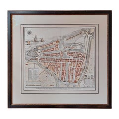
- Antique City Plan of Rotterdam in Frame, ca.1850Located in Langweer, NLAntique map titled 'Grondkaart der stad Rotterdam (..)'. Original antique city plan of Rotterdam, the Netherlands. Published circa 1850. Artists...Category
Antique 19th Century Prints
MaterialsPaper
- Antique Map of Asia by with an Inset Map of Turkey in Asia, 1868Located in Langweer, NLAntique map Asia titled 'Carte Politique et Ethnographique d'Asie'. Old map of Asia with an inset map of Turkey in Asia. Includes descriptive text box...Category
Antique 19th Century Maps
MaterialsPaper
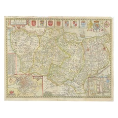
- Antique Map of Turkey in Europe, c.1780Located in Langweer, NLAntique map titled 'Bowles's new pocket map of Turky in Europe divided into its Provinces'. Large map of Turkey in Europe. Source unknown, to be determined. Artists and Engravers: Made by 'Thomas & Carington Bowles' after an anonymous artist. Thomas Bowles, born around 1712, was map publisher and seller in London...Category
Antique 18th Century Maps
MaterialsPaper
- Antique Map of the Russian Empire in Europe, ca.1780Located in Langweer, NLDescription: Antique map titled 'Bowles's New Pocket Map of the Russian Empire in Europe, Comprehending the West Part of the Empire in Asia' Large and detai...Category
Antique 1780s Maps
MaterialsPaper
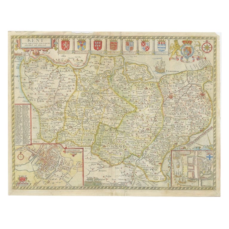
- Antique Map of Kent with Inset Plans of Rochester & Canterbury, England, 1676Located in Langweer, NLAntique map titled 'Kent with her Cities and Earles described and observed'. Map of Kent, England. Includes inset town plans of Rochester and Canterbury....Category
Antique 17th Century Maps
MaterialsPaper


You May Also Like
- Original Antique Map / City Plan of Brussels by Tallis, circa 1850Located in St Annes, LancashireGreat map of Brussels. Steel engraving. Published by London Printing & Publishing Co. (Formerly Tallis), C.1850 Free shipping.Category
Antique 1850s English Maps
MaterialsPaper
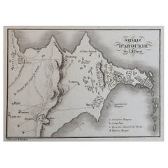
- Original Antique Plan of The Battle of Abukir, Napoleon Bonaparte. Circa 1850Located in St Annes, LancashireGreat battle plan of The Battle of Abukir Drawn by A.M Perrot Steel engraving by Tardieu with original hand colour Unframed. The size given is the paper sizeCategory
Antique 1850s French Maps
MaterialsPaper
- Map Turkey in Europe & Hungary Thomas Kitchin, 1783Located in BUNGAY, SUFFOLKThomas Kitchen (1718 - 1784) : Map of Turkey in Europe & Hungary 1783 Visible sheet within the cream mount 25.5cm., 10" height 20cm., 8" In an ebonised frame length 33cm. 13", height 28cm., 11" Kitchin, Thomas (1718 - 1784) Thomas Kitchin (August 4, 1718 – June 23, 1784) was a London based engraver, cartographer, and publisher. He was born in London to a hat-dyer of the same name. At 14, Kitchin apprenticed under Emanuel Bowen, under whom he mastered the art of engraving. He married Bowen daughter, Sarah Bowen, and later inherited much of his preceptor's prosperous business. Their son, Thomas Bowen Kitchin, also an engraver joined the family business, which thereafter published in Thomas Kitchin and Son. From 1858 or so Kitchin was the engraver to the Duke of York, and from about 1773 acquired the title, 'Royal Hydrographer to King George III.' He is responsible for numerous maps published in the The Star, Gentleman's Magazine, and London Magazine, as well as partnering with, at various times, with Thomas Jefferys, Emmanuel Bowen, Thomas Hinton, Issac Tayor, Andrew Dury, John Rocque, Louis de la Rochette, and Alexander Hogg, among others. Kitchin passed his business on to his son, Thomas Bowen Kitchin, who continued to republish many of his maps well after his death. Kitchin's apprentices included George Rollos...Category
Antique 18th Century English Georgian Maps
MaterialsPaper
- Antique Hand Colored Framed Map of EuropeLocated in West Palm Beach, FLAntique reproduction copied from an edition dated 1595 by Ortelius.Category
Antique Late 19th Century Maps
- Plan of Paris, France, by A. Vuillemin, Antique Map, 1845Located in Colorado Springs, COThis large and detailed plan of Paris was published by Alexandre Vuillemin in 1845. The map conveys a wonderful amount of information and is decorated throughout with pictorial vigne...Category
Antique 1840s American Maps
MaterialsPaper
- Gold Leaf Foil Pictorial Plan Map of the West Country of England Antique StyleLocated in GBWe are delighted to offer for sale this lovely Antique style pictorial plan map of the West Country of England etched in gold leaf foil This is a very interesting and decorative p...Category
20th Century English Adam Style Maps
MaterialsGold Leaf


Recently Viewed
View AllMore Ways To Browse
Antique In Europe
1850 Country Furniture
Bulgaria Antique
Turkish Map
Map Of Turkey
Turkey Map
Bosnia And Herzegovina
Bulgarian Artists
Croatian Artist
Antique Turkish Map
Antique Map Of Turkey
Albanian Antique
Map Of European Countries
Antique Macedonia
Bulgarian Antiques
Bulgaria Map
Bosnian Artists
Croatia Antique Map