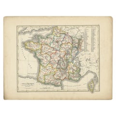

Antique Map of France from an Old Dutch School Atlas, 1852
Located in Langweer, NL
Antique map titled 'Frankrijk'. Map of France. This map originates from 'School-Atlas van alle
Category
Antique 19th Century Maps
Materials
Paper
Antique Map of France from an Old Dutch School Atlas, 1852
Located in Langweer, NL
Antique map titled 'Frankrijk'. Map of France. This map originates from 'School-Atlas van alle
Paper

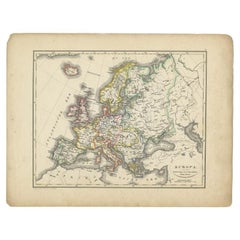
Antique Map of Europe from an Old Dutch School-Atlas, 1852
Located in Langweer, NL
Antique map titled 'Europa'. Map of Europe. This map originates from 'School-Atlas van alle deelen
Paper
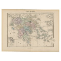

Antique Map of Greece from an Old French School Atlas, 1880
Located in Langweer, NL
Antique map titled 'Grèce Moderne '. Old map of Greece and surroundings. This map originates from
Paper

$206Sale Price|20% Off
H 13.59 in W 10.63 in D 0 in
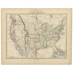
Antique Map of North America from an Old Dutch School Atlas, 1852
Located in Langweer, NL
Antique map titled 'Noord-Amerika'. Map of North America. This map originates from 'School-Atlas
Paper
$177Sale Price|20% Off
H 10.63 in W 13.59 in D 0 in
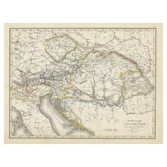
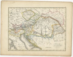
Original Antique Map of Austria from an Old Dutch School Atlas, 1852
Located in Langweer, NL
Antique map titled 'Het Keizerrijk Oostenrijk'. Map of the Austrian Empire. This map originates
Paper

$140
H 10.63 in W 13.59 in D 0 in
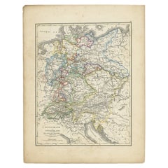
Antique Map of Germany and Switzerland from an Old Dutch School Atlas, 1852
Located in Langweer, NL
Antique map titled 'Duitschland en Zwitersland'. Map of Germany and Switzerland. This map
Paper

$128
H 12.88 in W 10.32 in D 0 in
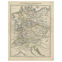
Antique Map of Germany and Switzerland from an Old Dutch School Atlas, c.1873
Located in Langweer, NL
Antique map titled 'Deutschland en Zwitserland'. Old map depicting Germany and Switzerland. This
Paper
$1,800 / item
H 19.69 in W 14.18 in D 0.12 in
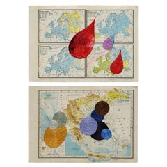
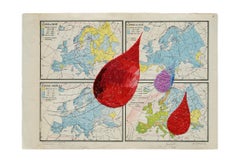
Untitled Diptych, Hand Embroidery on paper. From the series Cartografía
By Ana Seggiaro
Located in Miami Beach, FL
of imaginary geographies. This search leads her to tackle larger works. Thus, she recovers old school
Textile, Paper
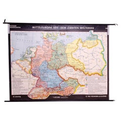
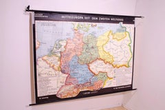
German Vintage school map of Central Europe, 1961
Located in Prague 8, CZ
Old Vintage school paper map of Central Europe. It was produced in 1961 in Germany. Map has on top
Wood, Paper
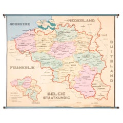
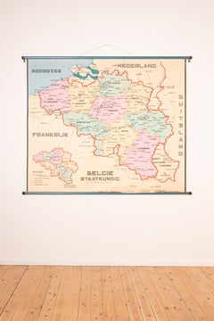
XL Old School Map of Belgium 'Printed by Procure', 1950s
Located in Oostende, BE
XL Old school map of Belgium (Printed by Procure). Presumably from around 1950-1960.
Metal
Antique Map of the United States from an Old Dutch School Atlas, 1873
Located in Langweer, NL
Description: Antique map titled 'De Vereenigde Staten Noord-Amerika'. Old map depicting the United
Paper
Sold
H 66.74 in W 17.72 in D 0.04 in
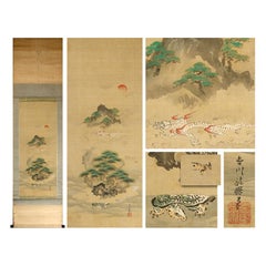
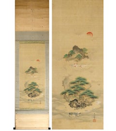
Kano School ca 1700 Scene Edo Period Scroll Japan 17/18c Artist Tosa Mitsunari
Located in Amsterdam, Noord Holland
As you can see, the "Edo period" Kano school old painting Unryu Horaiyama map / with a box. It is
Silk


Sold
H 38.98 in W 45.28 in D 1.97 in
School Chart or Pull Down Map of Geography of the Netherlands, 1950s
Located in Hemiksem, VAN
A beautiful old school map of the Netherlands, painted on linen. The map shows the 3 different
Linen, Paint

Czechoslovak Vintage Maps of the World in 1918-1938
Located in Prague 8, CZ
Old vintage school paper map of World in 1918-1938. It was produced in 1983 in the former
Paper
Produced in 1843, the well-preserved volume is evidence of the author's exacting specifications.
New or old, the coverlets add old-time charm to any space.
Get into the games! These items celebrate the events, athletes, host countries and sporting spirit.
French trendsetter and serial collector Daniel Rozensztroch tells us about his obsession with objects related to seafaring men.
It's hard to resist the allure of a beautiful pool. So, go ahead and daydream about whiling away your summer in paradise.
The sought-after designer worked with the team at Hoffman Creative to produce a monograph that beautifully showcases some of Studio Shamshiri's most inspiring projects.
Italian writer and collector Umberto Pasti opens the doors to his remarkable cave of wonders in North Africa.
Hollywood A-listers, ex-pat aristocrats and art collectors and style setters of all stripes appreciate the allure of the coastal California hamlet — much on our minds after recent winter floods.