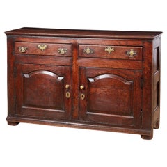
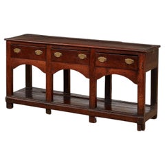
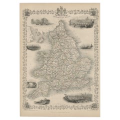
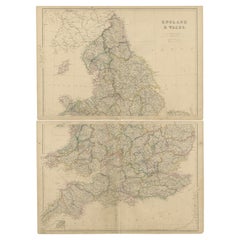
Georgian North Wales Low Dresser
Located in Greenwich, CT
Fine mid Georgian oak low cabinet dresser, North Wales circa 1750, the two plank top with molded
Category
Antique Mid-18th Century Welsh Georgian Sideboards
Materials
Oak
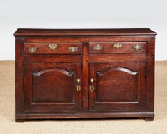
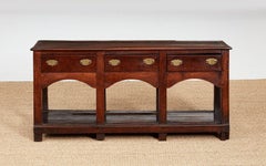
Georgian North Wales Low Dresser
Located in Greenwich, CT
Fine mid Georgian oak low cabinet dresser, North Wales circa 1750, the two plank top with molded
Oak
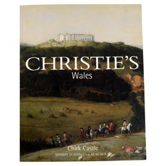
Christies 2004 Chirk Castle Wales 1st Ed
Located in valatie, NY
Christies 2004 Chirk Castle Wales. 1st Ed auction catalog. 656 lots on 296pp. color photos and
Paper
North Wales 8-Leg Potboard Dresser Base
Located in Greenwich, CT
A North Wales dresser base or sideboard having thick single board top with rounded edges over three
Oak
$400Sale Price|20% Off
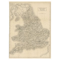
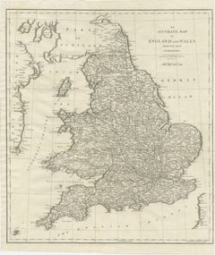
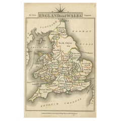
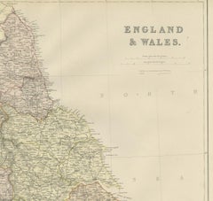
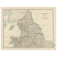
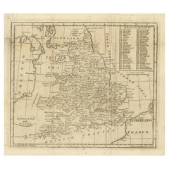
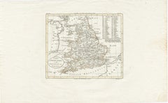
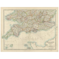
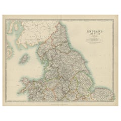
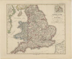
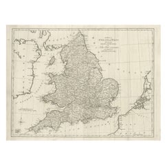
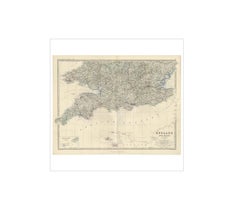
Antique Folding Map of England and Wales
Located in Langweer, NL
Antique map titled 'England and Wales'. Original folding map of England and Wales. Publishes by A
Paper
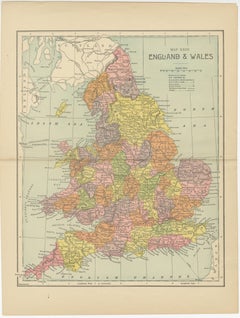
$181Sale Price|20% Off
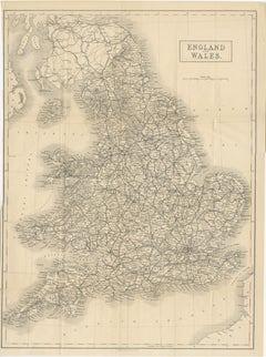
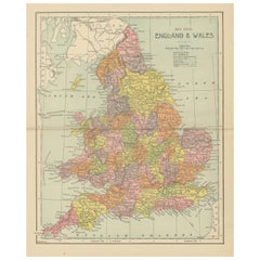
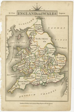
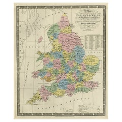
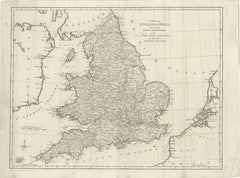
Lithographed Antique Map of England and Wales
Located in Langweer, NL
Original antique map titled 'Map XXIII England & Wales'. Lithographed map of England and Wales
Paper

$228Sale Price|20% Off
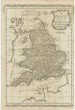
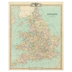
Original Antique Map of England and Wales
Located in Langweer, NL
Antique map titled 'A New and Correct Map of England and Wales from the Latest and Best
Paper
$314Sale Price|20% Off
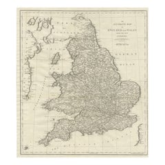
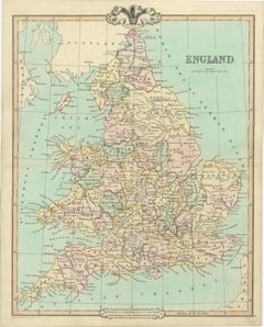
Large Antique Map of England and Wales
Located in Langweer, NL
Antique map titled 'An Accurate Map of England and Wales'. Original old map of England and Wales
Paper
$247Sale Price|20% Off
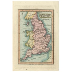
Miniature Antique Map of England and Wales
Located in Langweer, NL
Miniature map titled 'England & Wales'. Original antique map of England & Wales. This map
Paper

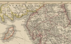
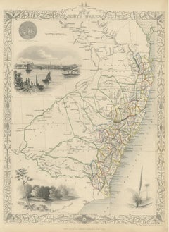
Map North Wales Robert Marsden Anglesey
Located in BUNGAY, SUFFOLK
Map of North Wales by Robert Marsden Including Anglesey Charming topography and detail and
Paper

$114Sale Price|20% Off
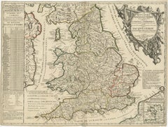
Antique Map of England and Wales with Roman Numerals
Located in Langweer, NL
Untitled original antique map of England and Wales. Drawn & Engraved for Cobbetts 'Geographical
Paper
$247Sale Price|20% Off
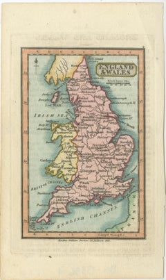
Miniature Map of England and Wales with Hand Coloring
Located in Langweer, NL
Antique map titled 'England and Wales'. An attractive miniature map of England and Wales enhanced
Paper
$162Sale Price|20% Off
Colorful Detailed Antique Map of England and Wales, 1882
Located in Langweer, NL
Explore the Historic Splendor of 'England and Wales' with this Antique Map! Part of a distinguished
Paper


$223Sale Price|25% Off
Antique Map of England and Wales by Johnson '1872'
Located in Langweer, NL
Antique map titled 'Johnson's England and Wales'. Original map of England and Wales. This map
Paper

$276Sale Price|20% Off
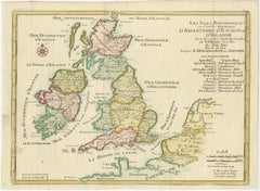
Original Antique Map of England, Ireland, Scotland and Wales
Located in Langweer, NL
of England, Ireland, Scotland and Wales, with French coast and part of the Netherlands. Shows
Paper


Antique Map of England and Wales by Johnston, 1882
Located in Langweer, NL
Antique map titled 'England and Wales'. Old map of England and Wales, with an inset map of Scilly
Paper

$152Sale Price|20% Off
Original Antique Map of England and Wales, with Decorative Cartouche
Located in Langweer, NL
Antique map titled 'England and Wales from the best Authorities'. Original antique map of England
Paper

$419Sale Price|20% Off
Original Antique Map of England and Wales with Large Cartouche
Located in Langweer, NL
of England and Wales by J.B. Nolin after Coronelli. With decorative cartouche, table and inset map of
Paper


Antique Map of, Northern England and Wales by Johnston, 1882
Located in Langweer, NL
Antique map titled 'England and Wales'. Old map of England and Wales. This map originates from
Paper
$171Sale Price|20% Off
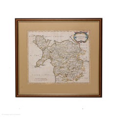
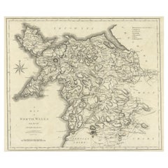
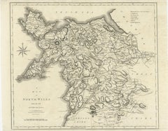
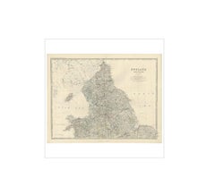
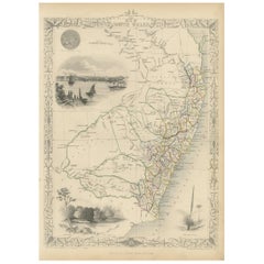
Large Antique County Map of North Wales, England
Located in Langweer, NL
Antique map titled 'A Map of North Wales from the best Authorities'. Original old county map of
Paper

$171Sale Price|20% Off
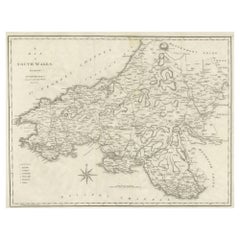
Large Antique County Map of South Wales, England
Located in Langweer, NL
Antique map titled 'A Map of South Wales from the best Authorities'. Original old county map of
Paper

$203Sale Price|20% Off
Antique Map of Northern England and Wales by Zatta, 1784
Located in Langweer, NL
map of the northern part of England and Wales, with title cartouche. Shows political and
Paper

$203Sale Price|20% Off
Antique Map of Southern England and Wales by Zatta, 1784
Located in Langweer, NL
of the southern part of England and Wales, with title cartouche. Shows political and administrative
Paper

$134Sale Price|24% Off
Antique Map of England & Wales by Wyld '1845'
Located in Langweer, NL
Antique map titled 'England & Wales'. Original antique map of England & Wales. This map originates
Paper
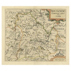

Original Antique Map of Brecknockshire, Wales, circa 1640
Located in Langweer, NL
Antique map titled 'Brecknoc comitaus pars olim silurum'. Original old map of Brecknockshire, Wales
Paper
Antique Map of England and Wales with Decorative Vignettes, 1851
Located in Langweer, NL
Antique map titled ‘England and Wales’. Includes decorative vignettes titled The grand stand on the
Paper
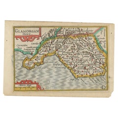
Miniature Antique Map of Glamorganshire, Wales, c.1646
Located in Langweer, NL
Antique map titled 'Glamorganshire'. Miniature map of Glamorganshire, Wales. Later, this map was
Paper

Antique Map of England and Wales, 1903, with Detailed Counties and Railways
Located in Langweer, NL
Title: Antique Map of England and Wales, 1903, with Detailed Counties and Railways Description
Paper

$133Sale Price|20% Off
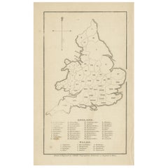
Antique Map of England and Wales, with References to the Counties
Located in Langweer, NL
Antique map titled 'England and Wales'. Original antique map of England and Wales, with references
Paper


$143Sale Price|20% Off
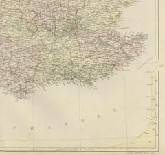
Antique Map of England and Wales, Also Showing the English Channel
Located in Langweer, NL
Antique map titled 'England and Wales'. Original antique map of England and Wales. Drawn and
Paper
$162Sale Price|20% Off
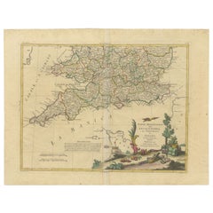
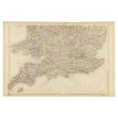
Colorful Detailed Antique Map of England and Wales (South Part), 1882
Located in Langweer, NL
Embark on a Journey Through the Southern Part of 'England and Wales' with this Exquisite Antique
Paper

$381Sale Price / set|20% Off
1859 Vintage Maps of England and Wales: Blackie's Imperial Geographic Detail
Located in Langweer, NL
The "Antique Map of England & Wales" from 'The Imperial Atlas of Modern Geography', published by W
Paper

$247Sale Price|20% Off
Detailed Antique Map of Britain, Wales and the Coast of Ireland
Located in Langweer, NL
Antique map titled 'Carta d'Inghilterra e del Principato di Galles'. Detailed map of Britain, Wales
Paper

Colourful Antique Map of England and Wales Divided in Counties, 1854
Located in Langweer, NL
Antique map titled 'A Map Shewing the Places in England & Wales Sending Members to Parliament
Paper

$95Sale Price|20% Off
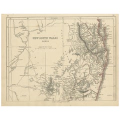
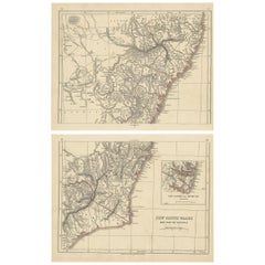
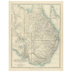
Antique Map of New South Wales by Lowry, '1852'
Located in Langweer, NL
Antique map titled 'New South Wales north'. Original map of New South Wales, Australia. This map
Paper

$238Sale Price|20% Off
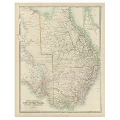
Antique Map of New South Wales by Johnston, '1909'
Located in Langweer, NL
Antique map titled 'South Australia, New South Wales, Victoria and Queensland'. Original antique
Paper

$143Sale Price / set|20% Off
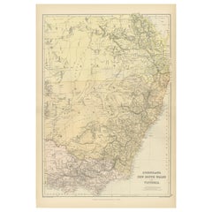
Antique Map of New South Wales by Lowry, 1852
Located in Langweer, NL
Antique map titled 'New South Wales and part of Victoria'. Two individual sheets of New South Wales
Paper
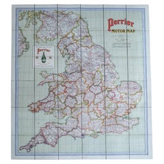
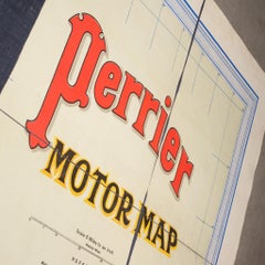
Early 20th c. England and Wales Perrier Motor Map c.1910
Located in San Francisco, CA
and Wales. Segmented in two sections and mounted to original linen back, folded into a cloth
Paper, Linen
Antique Map of Southern England & Wales, 1903, with Coastal Details and Railways
Located in Langweer, NL
Title: Antique Map of Southern England and Wales, 1903, with Coastal Details and Railways
Paper

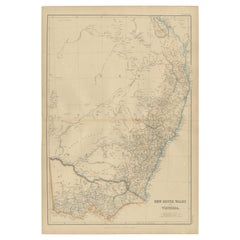
Antique Map of South Australia, New South Wales, Victoria and Queensland, 1903
Located in Langweer, NL
Title: Antique Map of South Australia, New South Wales, Victoria, and Queensland, 1903 Description
Paper
1882 Map of Queensland, New South Wales, and Victoria with Detailed Features
Located in Langweer, NL
This 1882 map of Queensland, New South Wales, and Victoria, published by Blackie and Son as part of
Paper

$238Sale Price|20% Off
Original Antique Map of England and Wales from the 1909 Royal Atlas
Located in Langweer, NL
The antique map titled 'England and Wales' is a historical cartographic representation of these two
Paper
$371Sale Price|20% Off
Antique Map of England and Wales, Also Including the Isle of Man
Located in Langweer, NL
Antique map titled 'England'. Original antique map of England and Wales from Northumberland to
Paper

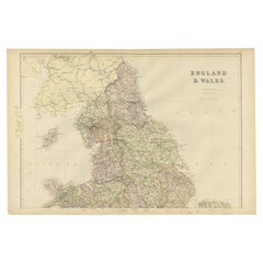
Antique Map of England and Wales 'North' by A.K. Johnston, 1865
Located in Langweer, NL
Antique map titled 'England and Wales (Northern Sheet)'. This map originates from the ‘Royal Atlas
Paper


$438Sale Price|20% Off
Small Antique Map of England, Wales, Scotland and Ireland with Original Coloring
Located in Langweer, NL
England, Wales, Scotland and Ireland with a portion of the coastline of France and the Netherlands. The
Paper
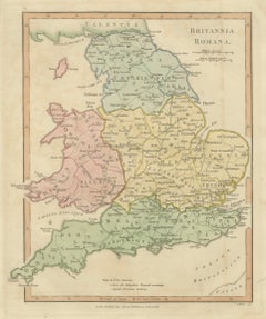
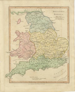
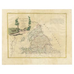
Roman Britain Map, Britannia Romana, Ancient England Wales Wilkinson 1817
Located in Langweer, NL
Roman Britain Map, Britannia Romana, Ancient England Wales Wilkinson 1817 This finely engraved and
Paper
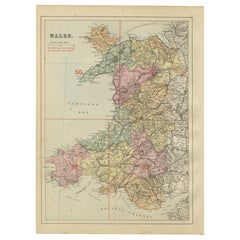

Antique Map of Wales, 1885 – County Colors, Railways & Coastal Detail
Located in Langweer, NL
Antique Map of Wales, 1885 – County Colors, Railways & Coastal Detail This decorative antique map
Paper
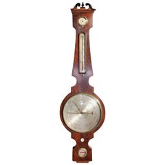
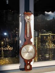
English Mahogany Prince of Wales Banjo Barometer, Circa 1820
Located in Charleston, SC
Prince of Wales motif, and original rotating bone dial. Barometer can be restored to working condition
Steel
England & Wales in 1857 – Decorative Antique Map with Rail Routes
Located in Langweer, NL
Antique Map of England & Wales – Hand-Colored Engraving by Stülpnagel, 1857 Fine 19th-century map
Paper


$238Sale Price|20% Off
Antique Map of New South Wales 'Australia' by Wyld '1845'
Located in Langweer, NL
Antique map titled 'British Settlements in New South Wales'. Original antique map of New South
Paper

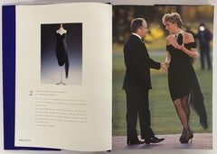
Dresses form the Collection of Diana, Princess of Wales (Book)
Located in North Yorkshire, GB
of Wales. The eighty lots included dresses by Catherine Walker, Victor Edelstein, Gina Fratini for
Paper
Antique Map of New South Wales by Tallis, circa 1851
Located in Langweer, NL
Antique map titled 'New South Wales'. Decorative and detailed map of New South Wales which was
Paper
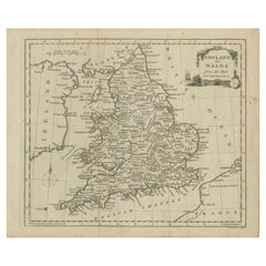
Antique Map of England and Wales by J. Blair, Circa 1779, Wall Art
Located in Langweer, NL
Antique map titled 'A Map of England and Wales (..)'. Large antique map of England and Wales, with
Paper

$238Sale Price|20% Off
Antique Map of New South Wales and Victoria by W. G. Blackie, 1859
Located in Langweer, NL
Antique map titled 'New South Wales and Victoria'. Original antique map of New South Wales and
Paper


Diana, Princess of Wales by Mario Testino at Kensington Palace
Located in CA, CA
Published by Taschen, accompanying the exhibition Diana Princess of Wales by Mario Testino at
Paper

Antique English Map – Southern England & Wales, Johnston’s Royal Atlas, 1865
Located in Langweer, NL
Antique Map of England & Wales (Southern Sheet) – Johnston’s Royal Atlas, 1865 This finely
Paper
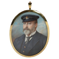
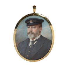
Miniature Portrait of the Prince of Wales, Later Edward VII
By Robert Henderson
Located in Lymington, Hampshire
A Very Fine and Important Miniature Portrait of the Prince of Wales, Later Edward VII, as Captain
Ivory, Satin, Glass, Paint
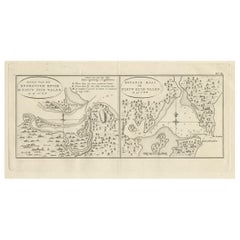
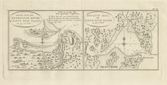
Antique Map of Endeavour River and Botany Bay, New South Wales, Australia, 1803
Located in Langweer, NL
Antique map Australia titled 'Mond van de Endeavour Rivier in Nieuw Zuid Wales' and 'Botanie Baai
Paper