
American Maps

to
8
149
74
224
12
7
7
5
2
1
1
2
181
41
22
13
4
9
6
2
5
2
1
2
215
18
11
7
6
202,195
1,787
608
500
380
224
224
224
27
2
2
2
2
Place of Origin: American
Vintage Blue Lapis Semi Precious Gemstone Spinning Globe with Brass Toned Stand

Vintage Blue Lapis Semi Precious Gemstone Spinning Globe with Brass Toned Stand

Located in Portsmouth, VA

This vintage gemstone globe has that collected, heirloom-like feel that works so well in traditional spaces. The oceans are made from deep blue lapis lazuli, giving it a rich, inky d...

Category

Mid-20th Century American Maps

Materials

Multi-gemstone

South Carolina Antique Map c.1888 – The Palmetto State, Railroads & Counties

South Carolina Antique Map c.1888 – The Palmetto State, Railroads & Counties

Located in Langweer, NL

Antique Map of South Carolina – Rand McNally, circa 1888 This antique map of South Carolina was published by Rand, McNally & Co. around 1888. Part of their celebrated late 19th-cent...

Category

Late 19th Century Antique American Maps

Materials

Paper

Floor Model Light Up Globe by Replogle Ca. 1950/1960's

Floor Model Light Up Globe by Replogle Ca. 1950/1960's

By Replogle Globes

Located in New York, NY

Exceptional light up floor model globe, by Replogle Globes Inc. The globe is 16 in. in diameter, it features an interior light, and restrain a solid mahogany frame. This example is i...

Category

Mid-20th Century Mid-Century Modern American Maps

Materials

Glass, Mahogany, Paper

Antique Map of Northern New York – Rand McNally, circa 1888

Antique Map of Northern New York – Rand McNally, circa 1888

Located in Langweer, NL

Antique Map of Northern New York – Rand McNally, circa 1888 This antique map of northern New York was published by Rand, McNally & Co. around 1888. Taken from one of their late 19th...

Category

Late 19th Century Antique American Maps

Materials

Paper

Large Decorative Map of Westchester County New York 1931 – Linen-Backed Wall Map

Large Decorative Map of Westchester County New York 1931 – Linen-Backed Wall Map

Located in Langweer, NL

Large Decorative Map of Westchester County NY 1931 – Linen-Backed Wall Map Description: 
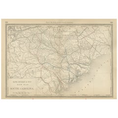
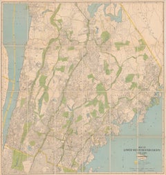
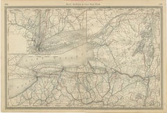
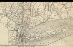
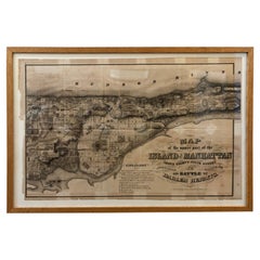
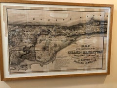
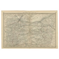
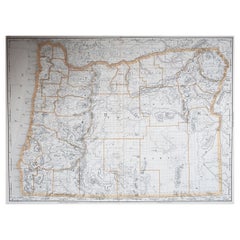
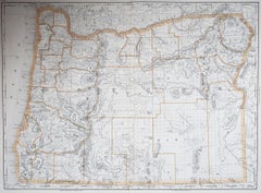
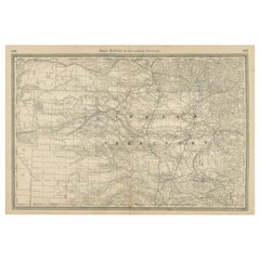
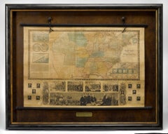
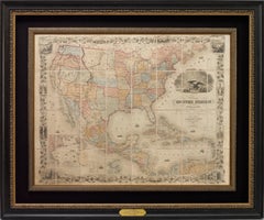
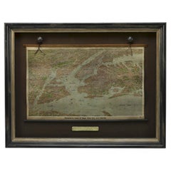
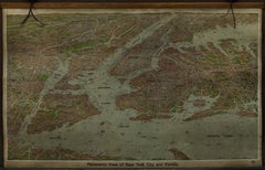
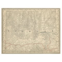
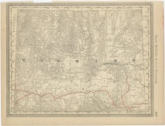
This impressive large-format decorative map of Lower Westchester County was published in 1931 by Dolph & Stewart and presents a richly detailed snapshot of suburban New York on the eve of major mid-20th-century expansion. Covering the area from Tarrytown in the north to just below the New York City boundary in the south, the map captures the dense network of towns, streets, rail lines, parks, and waterways that defined Westchester’s early commuter landscape. 
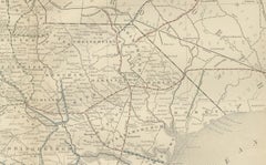
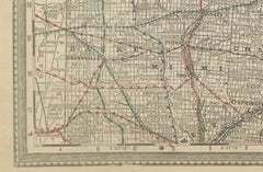
Prominently shown are Yonkers, Mount Vernon, New Rochelle, Rye, Scarsdale, White Plains, Harrison, Mamaroneck, Bronxville, Pelham, and Eastchester, with parts of the Bronx—including Van Cortlandt Park and Woodlawn Cemetery—clearly delineated along the southern edge. The Hudson River defines the western boundary, with a sliver of New Jersey visible beyond, while the northeastern portion extends into Connecticut. Parks and golf courses are highlighted in green, bodies of water in blue, and transportation routes—including railroads, stations, and ferry connections—are clearly identified. 
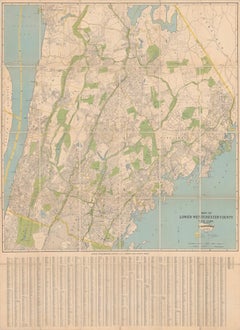
Below the main map is an extensive street and avenue index, making this not only a visually striking wall piece but also a fascinating historical reference. The cartography reflects early 20th-century planning priorities, emphasizing transportation infrastructure and residential development during a formative period for Westchester County as a desirable suburban extension of New York City. This example has been dissected and mounted on linen, as issued, allowing the large sheet to fold neatly while also making it especially suitable for framing. With its balanced pastel palette, fine linework, and substantial scale, the map works beautifully as a statement piece in both classic and modern interiors—particularly appealing to interior designers, architects, and collectors of American cartography. Condition: Issued folding, dissected and mounted on linen. Minor toning along some fold lines, with light foxing and a small amount of soiling near the upper edge. Overall a well-preserved and attractive example, with strong color and excellent legibility throughout.
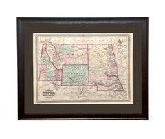
 Framing tips: This map presents best framed without glass glare in a large, clean-lined frame. A natural oak, walnut, or muted black frame with a narrow off-white or soft ivory mat will emphasize the scale and detail without overpowering the composition. For a more architectural look, consider float-mounting to reveal the linen backing. Keywords: Westchester County map, Lower Westchester, New York map, 1931 map, antique New York map, Westchester wall map, linen backed map, Yonkers map, White Plains map, Scarsdale map, New Rochelle map, Rye NY map, Mount Vernon map, Bronxville map, Pelham map, Eastchester map, Harrison NY map, Mamaroneck map, Tarrytown map, Hudson River map...

Category

1930s Vintage American Maps

Materials

Linen, Paper

New York State Antique Map c.1888 – The Empire State, Railroads & Counties

New York State Antique Map c.1888 – The Empire State, Railroads & Counties

Located in Langweer, NL

Antique Map of New York State – Rand McNally, circa 1888 This antique map of New York State was published by Rand, McNally & Co. around 1888. Unlike the sectional plates, this gener...

Category

Late 19th Century Antique American Maps

Materials

Paper

Antique Caribbean Map Wall Art – Cuba Jamaica Hispaniola, Rand McNally, ca.1888

Antique Caribbean Map Wall Art – Cuba Jamaica Hispaniola, Rand McNally, ca.1888

Located in Langweer, NL

Title: Antique Caribbean Map Wall Art – Cuba Jamaica Hispaniola, Rand McNally Description: This finely colored antique atlas map depicts the Caribbean basin, centered on Cuba, Jamaica, Hispaniola (Haiti and the Dominican Republic), Puerto Rico, and the Lesser Antilles. The composition balances dense geographic information with a calm, decorative aesthetic, making it especially attractive as wall art. Published by Rand, McNally & Co. in the late 19th century, the map combines precise cartography with elegant pastel color washes to distinguish islands and colonial boundaries. Delicate bathymetric lines fill the surrounding seas, adding texture and movement while enhancing the visual rhythm of the composition. The horizontal format reads beautifully in an interior setting, with the island chain stretching naturally across the sheet. Soft greens, yellows, pinks, and muted grays create a refined palette that works equally well in classic and contemporary spaces. While historically informative, the map functions first and foremost as a decorative object. Printed on original atlas paper, the sheet retains the authentic surface and tone of a genuine antique map. Once framed, it becomes an inviting focal point for a study, library, coastal home, or travel-inspired interior. Condition report: Light age toning consistent with age. Minor edge wear and small handling marks from original atlas binding. Overall clean and well preserved. Framing tips: Particularly effective in a light oak, walnut, or white-painted frame with an ivory mat. Museum glass recommended. Technique: Color lithograph Maker: Rand, McNally & Co., United States, late 19th century Keywords: antique caribbean map, cuba map wall art, jamaica antique...

Category

Late 19th Century Antique American Maps

Materials

Paper

Antique Florida Highway Map – Conners Highway, Lake Okeechobee Roads, ca.1924

Antique Florida Highway Map – Conners Highway, Lake Okeechobee Roads, ca.1924

Located in Langweer, NL

Antique Florida Highway Map 1924 – Conners Highway, Lake Okeechobee Roads This rare early automobile-era map, titled “Conners Highway Map of Main Highways of Florida Showing Surfaci...

Category

Early 20th Century American Maps

Materials

Paper

Antique Railroad & Township Map of Ohio by C.O. Titus, Paper, 1871

Antique Railroad & Township Map of Ohio by C.O. Titus, Paper, 1871

Located in Langweer, NL

Antique map titled 'Railroad & Township Map of the State of Ohio'. Original antique map of the State of Ohio. This map originates from 'Atlas of Preble County Ohio' by C.O. Titus...

Category

Late 19th Century Antique American Maps

Materials

Paper

1868 Map of the Upper Part of the Island of Manhattan Above 86th Street

1868 Map of the Upper Part of the Island of Manhattan Above 86th Street

By Wm. Rogers Mfg. Co.

Located in San Francisco, CA

This wonderful piece of New York City history is over 150 years old. It depicts 86th street and above. It was lithographed by WC Rogers and company. It was made to show what was the Battle of Harlem during the Revolutionary war...

Category

1860s American Colonial Antique American Maps

Materials

Paper

Washington Map 1888 – Antique Railroads, Indian Reservations & Counties

Washington Map 1888 – Antique Railroads, Indian Reservations & Counties

Located in Langweer, NL

Antique Map of Washington – Railroads, Counties & Indian Reservations, 1888 This original engraved map shows the Territory of Washington in 1888, a historically important moment jus...

Category

Late 19th Century Antique American Maps

Materials

Paper

Large Original Antique Map of Ireland. C.1900

Large Original Antique Map of Ireland. C.1900

Located in St Annes, Lancashire

Fabulous map of Ireland Original color. Engraved and printed by the George F. Cram Company, Indianapolis. Published, C.1900. Unframed. Free shipping.

Category

1890s Antique American Maps

Materials

Paper

Antique Map of England and Wales by Johnson '1872'

Antique Map of England and Wales by Johnson '1872'

Located in Langweer, NL

Antique map titled 'Johnson's England and Wales'. Original map of England and Wales. This map originates from 'Johnson's New Illustrated Family Atlas of the World' by A.J. Johnson. P...

Category

Late 19th Century Antique American Maps

Materials

Paper

Set of 6 Original Vintage Maps of American States, circa 1900

Set of 6 Original Vintage Maps of American States, circa 1900

Located in St Annes, Lancashire

Wonderful set of 6 vintage maps. Random American states including Maine, Utah, New Hampshire, Nevada, Vermont and New Mexico. Monochrome with red color outline. Published by Rand,...

Category

Early 1900s Edwardian Antique American Maps

Materials

Paper

Antique Map of Northern Ohio – The Buckeye State with Railroads & Counties, 1888

Antique Map of Northern Ohio – The Buckeye State with Railroads & Counties, 1888

Located in Langweer, NL

Antique Map of Northern Ohio – The Buckeye State with Railroads & Counties, 1888 This antique engraved map of Northern Ohio, published in 1888 by Rand, McNally & Co. in Chicago for ...

Category

Late 19th Century Antique American Maps

Materials

Paper

Large Original Antique Map of Oregon, USA, 1894

Large Original Antique Map of Oregon, USA, 1894

By Rand McNally & Co.

Located in St Annes, Lancashire

Fabulous map of Oregon. Original color. By Rand, McNally & Co. Published, 1894. Unframed. Free shipping.

Category

1890s Antique American Maps

Materials

Paper

Washington Oregon Idaho Map – Johnson, Hand-Colored, c.1864

Washington Oregon Idaho Map – Johnson, Hand-Colored, c.1864

Located in Langweer, NL

Johnson’s Washington Oregon Idaho Map, USA c.1864 – Hand-Colored This is a finely engraved and hand-colored map titled Johnson’s Washington, Oregon, and Idaho, published by Johnson ...

Category

Mid-19th Century Antique American Maps

Materials

Paper

Indian Territory Map 1888 – Rand McNally Antique Lithograph

Indian Territory Map 1888 – Rand McNally Antique Lithograph

Located in Langweer, NL

Indian Territory Map 1888 – Rand McNally Antique Lithograph This antique 1888 map of Indian Territory, published by Rand, McNally & Co., is a remarkable record of the region that wo...

Category

Late 19th Century Antique American Maps

Materials

Paper

1870 "Johnson's Nebraska, Dakota, Idaho, Montana and Wyoming" Antique Map

1870 "Johnson's Nebraska, Dakota, Idaho, Montana and Wyoming" Antique Map

Located in Colorado Springs, CO

Presented is an original 1870 "Johnson's Nebraska, Dakota, Idaho, Montana and Wyoming" map. First published in 1865, this map was issued as pages 76 and 77 in the 1870 edition of “Jo...

Category

1870s Victorian Antique American Maps

Materials

Paper

Large Original Antique Map of Africa. C.1900

Large Original Antique Map of Africa. C.1900

Located in St Annes, Lancashire

Fabulous map of Africa Original color. Engraved and printed by the George F. Cram Company, Indianapolis. Published, C.1900. Unframed. Free shipping.

Category

1890s Antique American Maps

Materials

Paper

Original Antique City Plan of Cleveland, Ohio, USA, circa 1900

Original Antique City Plan of Cleveland, Ohio, USA, circa 1900

By Rand McNally & Co.

Located in St Annes, Lancashire

Fabulous colorful map of Cleveland Original color By Rand, McNally & Co. Published, circa 1900 Unframed Free shipping.

Category

1890s Antique American Maps

Materials

Paper

Hand Colored Map of Nantucket by Austin Strong (1881 - 1952), circa 1921

Hand Colored Map of Nantucket by Austin Strong (1881 - 1952), circa 1921

Located in Nantucket, MA

Map of Nantucket by Austin Strong (1881 - 1952), circa 1921, an original print on paper whimsical map of Nantucket Island by Robert Louis Stevenson's step- grandson, noted stage set ...

Category

1920s Folk Art Vintage American Maps

Materials

Paper

Framed Map of Texas Circa 1886

Framed Map of Texas Circa 1886

Located in Coeur d'Alene, ID

Framed circa 1886 map of Texas including Louisiana, Texas and Arkansas, with Indian territory. Well detailed. Great for display in any home. Encased in cherry and gold frame with dar...

Category

Late 19th Century Antique American Maps

Materials

Paper

1888 Antique Map of Oregon – Railroads, Counties & Native Indian Reservations

1888 Antique Map of Oregon – Railroads, Counties & Native Indian Reservations

Located in Langweer, NL

Antique Map of Oregon – Railroads, Indian Reservations & Counties, 1888 This antique engraved map presents the state of Oregon in 1888, a time when the Pacific Northwest was rapidly...

Category

Late 19th Century Antique American Maps

Materials

Paper

Scarce U.S. Coast Survey Map Depicting Entrance to San Francisco Bay Dated 1856

Scarce U.S. Coast Survey Map Depicting Entrance to San Francisco Bay Dated 1856

Located in San Francisco, CA

A fine example of the 1856 U.S. Coast lithographic survey nautical chart of the entrance to San Francisco bay and the city. Published in 1856 by the Office of the Coast Survey the of...

Category

Mid-19th Century Antique American Maps

Materials

Paper

19th C. Terrestrial Globe on Stand for H.B. Nims After Copley

19th C. Terrestrial Globe on Stand for H.B. Nims After Copley

Located in Bridgeport, CT

Manufactured for H.B. Nims & Co., Troy New York, last quarter 19th c. After the original engravings by Charles Copley done in 1852. Printed paper on wood with brass/ bronze meridian ring and a flat circular printed center horizon ring on wood labeled with the months of the year with notes. Mounted on a fine leafy iron baluster...

Category

Late 19th Century Victorian Antique American Maps

Materials

Bronze, Iron

1845 "Ensign's Travellers' Guide and Map of the United States" Hand-Colored Map

1845 "Ensign's Travellers' Guide and Map of the United States" Hand-Colored Map

Located in Colorado Springs, CO

This is an exquisite and dramatic steel-engraved wall map of the United States, published by T. & E. H. Ensign in 1845. The map depicts the development and settlement of the Unit...

Category

1840s Victorian Antique American Maps

Materials

Paper

Antique Webber Costello Globe on Metal Tripod Base c 1900 / 1920's

Antique Webber Costello Globe on Metal Tripod Base c 1900 / 1920's

Located in New York, NY

Rare floor model globe made by Weber Costello, circa 1900. The 12" globe rests on a folding metal base. This example is in very good, original condition, showing only light wear, nor...

Category

Early 20th Century Industrial American Maps

Materials

Metal

1847 Antique Map of Mexico, Texas and California by Samuel Augustus Mitchell

1847 Antique Map of Mexico, Texas and California by Samuel Augustus Mitchell

By Samuel Augustus Mitchell 1

Located in Colorado Springs, CO

Presented is the second edition of Samuel Augustus Mitchell's Map of Mexico, Including Yucatan & Upper California, an important map showing the progress of the Mexican-American War. ...

Category

1840s Antique American Maps

Materials

Paper

1856 "Map of the United States" by Ensign, Bridgeman, and Fanning

1856 "Map of the United States" by Ensign, Bridgeman, and Fanning

Located in Colorado Springs, CO

Presented is a scarce American wall map of the United States and Mexico issued by Ensign, Bridgman, and Fanning in 1856. As the title suggests, the map covers all of the United State...

Category

1850s Victorian Antique American Maps

Materials

Paper

18th Century Hand Colored Map of The State of Massachusetts, 1796

18th Century Hand Colored Map of The State of Massachusetts, 1796

Located in Nantucket, MA

18th Century Hand Colored Map of "The State of Massachusetts from the best information," 1796, by cartographer and illustrator John Reid published in his "American Atlas," a period e...

Category

1790s American Colonial Antique American Maps

Materials

Paper

1912 "Panoramic View of New York City and Vicinity" by Jacob Ruppert

1912 "Panoramic View of New York City and Vicinity" by Jacob Ruppert

Located in Colorado Springs, CO

This is an attractive and very scarce map of New York, published by the Yorkville brewer Jacob Ruppert in 1912. The map shows an expansive view of the region reaching from Sandy Hook in the south and Yonkers to the north, to Hicksville in the east and past Newark to the west. This beautifully colored birds eye view shows waterways with all shipping traffic, boroughs, and clearly labeled railroad routes. It is presented on period dowels and backed on its original linen. Jacob Ruppert was born in New York City in 1842 to Bavarian immigrants. His father owned a brewery in Manhattan where young Jacob learned the business of brewing. In 1862, Jacob established the Jacob...

Category

1910s Vintage American Maps

Materials

Paper

1899 Poole Brothers Antique Railroad Map of the Illinois Central Railroad

1899 Poole Brothers Antique Railroad Map of the Illinois Central Railroad

Located in Colorado Springs, CO

This is an 1899 railroad map of the Illinois Central and Yazoo and Mississippi Valley Railroads, published by the Poole Brothers. The map focuses on the continuous United States from the Atlantic to the Pacific Oceans, the Gulf of Mexico, and the Antilles. Remarkably detailed, the rail routes of the Illinois Central RR are marked in red, which each stop labeled. Major stops are overprinted in red, bold letters, with the short rail distances to New York listed above the stop and short rail distances to New Orleans listed below the name. In addition to the Illinois Central network, numerous different rail lines are illustrated and the company running that line is noted along with many stops along each route. Sea routes from New Orleans to locations in Central America, the Caribbean, and Europe are marked and labeled with destination and distance, along with routes originating from Havana. Inset at bottom left is a map of Cuba; an inset map of Puerto Rico...

Category

1890s Antique American Maps

Materials

Paper

Large Original Antique Map of North Carolina, USA, 1894

Large Original Antique Map of North Carolina, USA, 1894

By Rand McNally & Co.

Located in St Annes, Lancashire

Fabulous map of North Carolina Original color By Rand, McNally & Co. Published, 1894 Unframed Free shipping.

Category

1890s Antique American Maps

Materials

Paper

Plan of Paris, France, by A. Vuillemin, Antique Map, 1845

Plan of Paris, France, by A. Vuillemin, Antique Map, 1845

Located in Colorado Springs, CO

This large and detailed plan of Paris was published by Alexandre Vuillemin in 1845. The map conveys a wonderful amount of information and is decorated throughout with pictorial vigne...

Category

1840s Antique American Maps

Materials

Paper

Rare and Early Plaster Relief Map of Adirondack Mountains by F J H Merrill

Rare and Early Plaster Relief Map of Adirondack Mountains by F J H Merrill

By P.F. Howells, E. W. Merrill

Located in Buffalo, NY

Rare and Early Monumental Plaster Relief Map of Adirondack Mountains by The University of the State of New York, New York State Museum..F J H Merrill director,,,modeled by Howell's ...

Category

1910s Industrial Vintage American Maps

Materials

Plaster, Wood

Physical Relief Map of Africa, 1970s Educational Decor

Physical Relief Map of Africa, 1970s Educational Decor

Located in New Windsor, NY

Physical relief map of Africa. Jerry, our artist, has painstakingly reproduced the desserts, rivers, mountains and jungles of the continent of Africa, along with altitude legend on t...

Category

Late 20th Century Mid-Century Modern American Maps

Materials

Masonite, Paint

Rare 18th C. Newport Map

Rare 18th C. Newport Map

Located in Sandwich, MA

Rare 18th C, Map titled "A plan of the town of Newport in the province of Rhode Island". Earliest printed plan of Newport, published for the use of the British just prior to their o...

Category

1770s Antique American Maps

Materials

Paper

Nantucket High-Ways, By-Ways and Not-Ways Decorative Map by Tony Sarg, ca 1930

Nantucket High-Ways, By-Ways and Not-Ways Decorative Map by Tony Sarg, ca 1930

By Tony Sarg

Located in Nantucket, MA

Vintage Nantucket High-Ways, By-Ways and Not-Ways Decorative Map by Tony Sarg, (Nantucket: 1880 - 1942) circa 1930, a decorative tourist map of Nantucket Island with details of roadw...

Category

1930s Other Vintage American Maps

Materials

Paper

1840 Map of the City of Washington Published by William M. Morrison

1840 Map of the City of Washington Published by William M. Morrison

Located in Colorado Springs, CO

This map, printed in 1840, is a detailed representation of Washington, D.C. in the mid-19th century. The map shows block numbers, wards, and government buildings as well as details o...

Category

1840s Federal Antique American Maps

Materials

Paper

16-Inch Terrestrial Globe 1986 National Geographic

16-Inch Terrestrial Globe 1986 National Geographic

By National Geographic

Located in Ottawa, Ontario

A 16-INCH TERRESTRIAL GLOBE 1986 NATIONAL GEOGRAPHIC Large terrestrial globe with paper gores on a stylish black lucite base scale 1: 31,350,000 18" inches, (45.5cm.) high. 16" in...

Category

Late 20th Century Modern American Maps

Materials

Metal

Antique Wyoming Map Wall Art – Railroads, Mountains & Plains, circa 1888

Antique Wyoming Map Wall Art – Railroads, Mountains & Plains, circa 1888

Located in Langweer, NL

Title: Antique Wyoming Map Wall Art – Railroads & Rocky Mountains, Rand McNally Description: This original antique atlas map presents the state of Wyoming in fine detail, showin...

Category

Late 19th Century Antique American Maps

Materials

Paper

1854 Map of Massachusetts, Connecticut and Rhode Island, Antique Wall Map

1854 Map of Massachusetts, Connecticut and Rhode Island, Antique Wall Map

Located in Colorado Springs, CO

This striking wall map was published in 1854 by Ensign, Bridgman & Fanning and has both full original hand-coloring and original hardware. This impression is both informative and highly decorative. The states are divided into counties, outlined in red, green, and black, and subdivided into towns. Roads, canals, and railroad lines are prominently depicted, although they are not all labeled. The mapmakers also marked lighthouses, banks, churches, and prominent buildings, with a key at right. The map is an informative and comprehensive overview of the infrastructural development of New England prior to the Civil War. Physical geographies depicted include elevation, conveyed with hachure marks, rivers and lakes. The impression features an inset map of Boston...

Category

19th Century Antique American Maps

Materials

Paper

Antique Ontario Map Wall Art – Lake Superior & Northern Ontario, ca.1888

Antique Ontario Map Wall Art – Lake Superior & Northern Ontario, ca.1888

Located in Langweer, NL

Title: Antique Ontario Map Wall Art – Lake Superior & Northern Ontario, Rand McNally This original antique atlas map depicts Ontario with a strong focus on Lake Superior, Lake N...

Category

Late 19th Century Antique American Maps

Materials

Paper

Antique Pennsylvania Map Wall Art – Railroads, Mountains & Cities, Rand McNally

Antique Pennsylvania Map Wall Art – Railroads, Mountains & Cities, Rand McNally

Located in Langweer, NL

Title: Antique Pennsylvania Map Wall Art – Railroads, Mountains & Cities, Rand McNally Description: This original antique atlas map depicts the state of Pennsylvania in exceptio...

Category

Late 19th Century Antique American Maps

Materials

Paper

Florida 1888 Antique Map – Railroads, Settlements & Gulf Coast Detail

Florida 1888 Antique Map – Railroads, Settlements & Gulf Coast Detail

Located in Langweer, NL

Florida Map 1888 – Rand McNally Antique Lithograph This antique 1888 map of Florida, published by Rand, McNally & Co., presents a detailed view of the state in the late 19th century...

Category

Late 19th Century Antique American Maps

Materials

Paper

1888 Colorado Map – The Centennial State’s Railroads, Mines & Counties

1888 Colorado Map – The Centennial State’s Railroads, Mines & Counties

Located in Langweer, NL

Antique Map of Colorado – Railroads, Mining Towns & Counties, 1888 This antique engraved map depicts the state of Colorado in 1888, published by Rand, McNally & Co. in Chicago for t...

Category

Late 19th Century Antique American Maps

Materials

Paper

Texas Antique Map 1888 – Railroads, Counties & Frontier Settlements

Texas Antique Map 1888 – Railroads, Counties & Frontier Settlements

Located in Langweer, NL

Texas Railroad Map 1888 – Rand McNally Antique Lithograph This antique 1888 map of Texas, published by Rand, McNally & Co., provides a detailed overview of the state during a critic...

Category

Late 19th Century Antique American Maps

Materials

Paper

Antique Rhode Island Map Wall Art – Providence & Newport, Rand McNally, ca.1888

Antique Rhode Island Map Wall Art – Providence & Newport, Rand McNally, ca.1888

Located in Langweer, NL

Title: Antique Rhode Island Map Wall Art – Providence & Newport, Rand McNally Description: This original antique atlas map depicts the state of Rhode Island in remarkable late-1...

Category

Late 19th Century Antique American Maps

Materials

Paper

Antique Northwest Texas Map – Panhandle Railroads & Counties, Rand McNally, 1888

Antique Northwest Texas Map – Panhandle Railroads & Counties, Rand McNally, 1888

Located in Langweer, NL

Title: Antique Northwest Texas Map – Panhandle Railroads & Counties, Rand McNally Description: This original antique atlas map depicts Northwest Texas and the Panhandle, showing...

Category

Late 19th Century Antique American Maps

Materials

Paper

Antique Minnesota Map Wall Art by Rand McNally, Color Lithograph, 1888

Antique Minnesota Map Wall Art by Rand McNally, Color Lithograph, 1888

Located in Langweer, NL

Title: Antique Minnesota Map Wall Art – Railroads, Lakes & Cities, Rand McNally Description: This original antique atlas map depicts the state of Min...

Category

Late 19th Century Antique American Maps

Materials

Paper

Antique South America Map Wall Art – Brazil, Andes & Amazon, Rand McNally, 1888

Antique South America Map Wall Art – Brazil, Andes & Amazon, Rand McNally, 1888

Located in Langweer, NL

Title: Antique South America Map Wall Art – Brazil, Andes & Amazon, Rand McNally Description: This original antique atlas map presents the full continent of South America in richly ...

Category

Late 19th Century Antique American Maps

Materials

Paper

Antique Map of Kentucky & Tennessee – The Bluegrass & Volunteer States, 1888

Antique Map of Kentucky & Tennessee – The Bluegrass & Volunteer States, 1888

Located in Langweer, NL

Antique Map of Kentucky & Tennessee – The Bluegrass & Volunteer States, 1888 This antique engraved map of Kentucky and Tennessee, published in 1888 by Rand, McNally & Co. in Chicago for their Improved Indexed Business Atlas and Shippers Guide, provides a highly detailed view of two historically important Southern states in the late 19th century. It shows counties, towns, and an extensive network of railroads, capturing a period when rail transportation was rapidly transforming the economy and society of the post-Civil War South. The Kentucky section, titled “New County and Railroad Map of Kentucky,” highlights the state’s counties, with Louisville, Lexington, Covington, and Frankfort (the state capital) standing out as major centers. Known as “The Bluegrass State,” Kentucky was already famous for its fertile farmland, thoroughbred horse breeding, and bourbon whiskey industry. The map shows dense railroad coverage, including the Louisville & Nashville Railroad, which connected Kentucky to major markets in the Midwest and South. The Tennessee portion, titled “County and Railroad Map of Tennessee,” provides similar detail. Counties such as Shelby, Davidson, Knox, and Hamilton are clearly marked, along with the major cities of Memphis, Nashville (the state capital), Knoxville, and Chattanooga. Known as “The Volunteer State,” Tennessee played a critical role in American history, from its frontier heritage to its importance during the Civil War. By 1888, Tennessee’s economy was diversifying, with Memphis as a cotton trading hub, Nashville as a growing cultural and commercial center, and Chattanooga as a key industrial city connected to the railroads. The map’s railroad...

Category

Late 19th Century Antique American Maps

Materials

Paper

Arkansas Map by Colton, USA Published c.1864 – Hand-Colored County Map

Arkansas Map by Colton, USA Published c.1864 – Hand-Colored County Map

Located in Langweer, NL

Arkansas Map by Colton, USA Published c.1864 – Hand-Colored County Map This is a finely engraved and hand-colored map titled Arkansas, published by G.W. & C.B. Colton & Co. in New Y...

Category

Mid-19th Century Antique American Maps

Materials

Paper

Maine County Map – Johnson, Hand-Colored, USA c.1864

Maine County Map – Johnson, Hand-Colored, USA c.1864

Located in Langweer, NL

Johnson’s Maine Map, USA Published c.1864 – Hand-Colored County Map This is a finely engraved and hand-colored map titled Johnson’s Maine, published by Johnson and Ward in New York ...

Category

Mid-19th Century Antique American Maps

Materials

Paper

Antique Map of Indiana – The Hoosier State with Railroads & Counties, 1888

Antique Map of Indiana – The Hoosier State with Railroads & Counties, 1888

Located in Langweer, NL

Antique Map of Indiana – The Hoosier State with Railroads & Counties, 1888 This antique engraved map of Indiana, published in 1888 by Rand, McNally & Co. in Chicago for their *Impro...

Category

Late 19th Century Antique American Maps

Materials

Paper