
Jacques-Nicolas Bellin Prints

French, 1703-1772
Jacques Nicolas Bellin (1703 –1772) was a French hydrographer (official cartographer) and a geographer. While still a teenager he became the chief cartographer to the French Navy and later to the king of France. Bellin created a large number of maps for Antoine François Prévost's (L'Abbe Prevost) 'Histoire Generale des Voyages', which was a 25 volume publication focused on 17th and 18th century exploration.It was published in French, Dutch and German. He also contributed maps and articles to the 35-volume Encyclopédie edited by Denis Diderot and Jean le Rond d'Alembert. He was part of the group called Philosophes, which included many of the great intellectuals of the Age of Enlightenment, including Voltaire, Rousseau and Montesquieu. Bellin died at Versailles in 1772.
(Biography provided by Timeless Intaglio)
18
to
2
15
3
18
18
18
2
18
Height
to
Width
to
18
9
5
2
35
107
95
90
85
Creator: Jacques-Nicolas Bellin
Antique Print of Fort St. Louis Near the Senegal River, circa 1747
By Jacques-Nicolas Bellin
Located in Langweer, NL
Antique print titled 'Plan du Fort St. Louis dans l'Isle de Sanaga ou du Senegal'. Old print with a plan of Fort St. Louis near the Senegal River. This print orginates from 'Histoire...
Category

18th Century Antique Jacques-Nicolas Bellin Prints

Materials

Paper

Schley, Xinjiang Uygur Zizhiqu, Tien Shan, Sinkiang, Map of China
By Jacques-Nicolas Bellin
Located in Norwich, GB
J.V. Schley Carte de la petite Bukharie et pays voisins ; Kaart van Klyn-Bukharia, en de nabuurige landen Xinjiang Uygur Zizhiqu (China), Tien Shan, Sinkiang. Relief shown pict...
Category

1740s Dutch Antique Jacques-Nicolas Bellin Prints

Materials

Paper

Bellin, Canada, Gulf of Saint Lawrence, Hand Coloured Engraving
By Jacques-Nicolas Bellin
Located in Norwich, GB
J.V. Schley after Bellin ‘Carte du Golphe de St. Laurent et Pays Voisins’ Size: 14.2 x 8.6 inches 36.1 x 21.8 cm First state of this nice copper engraved map of St. Lawrence Bay with Anticosti Island, Prince Edward Island, Cape Breton...
Category

1780s French Antique Jacques-Nicolas Bellin Prints

Materials

Paper

Marine Pavillons, Flags, Folio in Original Hand Color
By Jacques-Nicolas Bellin
Located in Norwich, GB
Tableau des Pavillons Que la Plupart des Nations Arborent a La Mer- Marine Flags After Jacques-Nicolas Bellin. Copperplate engraving and et...
Category

1780s French Georgian Antique Jacques-Nicolas Bellin Prints

Materials

Paper

Jacques Nicolas Bellin, St Lucia, West Indies, Hand Colored Map
By Jacques-Nicolas Bellin
Located in Norwich, GB
Carte De L’Isle De Sainte Lucie Detailed copper engraved map of Saint Lucia by Jacques Nicolas Bellin. This map was completed by Krevely 1775 for for the rare Dutch edition of ...
Category

1770s Dutch Georgian Antique Jacques-Nicolas Bellin Prints

Materials

Paper

Antique Colored Engraving of Madras 'Chennai' and Fort St. George in India, 1751
By Jacques-Nicolas Bellin
Located in Langweer, NL
Antique print titled 'Plan de Madras et du Fort St. Georges'. Plan of the city of Madras (or Chennai), the capital of the state of Tamil Nadu, India. Also shows a plan of Fort St. Ge...
Category

18th Century Antique Jacques-Nicolas Bellin Prints

Materials

Paper

Captain Cook's Exploration of Tahiti 18th C. Hand-Colored Map by Bellin
By Jacques-Nicolas Bellin
Located in Alamo, CA
This beautiful 18th century hand-colored copper plate engraved map is entitled "Carte de l'Isle de Taiti, par le Lieutenant J. Cook" was created by Jacques Nicolas Bellin and publish...
Category

Mid-18th Century French Antique Jacques-Nicolas Bellin Prints

Materials

Paper

Antique Print of the Island of Gorée by Bellin, c.1748
By Jacques-Nicolas Bellin
Located in Langweer, NL
Antique print Africa titled 'Vue de la Rade de l'Ile de Gorée'. Antique print depicting the island of Gorée, Senegal. Artists and Engravers: ...
Category

18th Century Antique Jacques-Nicolas Bellin Prints

Materials

Paper

Antique Map of Cities in the Hubei and Hunan Provinces of China, 1755
By Jacques-Nicolas Bellin
Located in Langweer, NL
Antique print titled 'Plans de Quelques villes de la province de Hou-Quang.' Three bird's-eye view plans of walled cities in what are now China's Hubei (Hou-Quang) and Hunan Province...
Category

18th Century Antique Jacques-Nicolas Bellin Prints

Materials

Paper

Antique Map of Cities of the Jiangsu Region in China, c.1760
By Jacques-Nicolas Bellin
Located in Langweer, NL
Antique map titled 'Plan de l' Enceinte de la Ville de Nan-King ou Kyang-Ning-Fou et plan de la ville de Su-Tcheou-Fou.' A map of the city of Nanking or Nanjing and a second map show...
Category

18th Century Antique Jacques-Nicolas Bellin Prints

Materials

Paper

Antique Map of Cities of the Province of Shanxi in China, 1749
By Jacques-Nicolas Bellin
Located in Langweer, NL
Antique print titled: 'Lan-Tcheou ou Lan-Chew dan la province Chensi; Can Tcheou ou Kan-Chew dan la province de Chensi; Tchin-Ywe-Fou ou Chin-Ywen-Fu dans la province de Koei-Tcheou ...
Category

18th Century Antique Jacques-Nicolas Bellin Prints

Materials

Paper

West Coast of Africa, Guinea & Sierra Leone: An 18th Century Map by Bellin
By Jacques-Nicolas Bellin
Located in Alamo, CA
Jacques Bellin's copper-plate map entitled "Partie de la Coste de Guinee Dupuis la Riviere de Sierra Leona Jusquau Cap das Palmas", depicting the coast of Guinea and Sierra Leone in ...
Category

Mid-18th Century French Antique Jacques-Nicolas Bellin Prints

Materials

Paper

St. Christophe 'St. Kitts' Island: An 18th Century Hand-colored Map by Bellin
By Jacques-Nicolas Bellin
Located in Alamo, CA
Jacques Bellin's copper-plate map of the Caribbean island of Saint Kitts entitled "Carte De De l'Isle St. Christophe Pour servir á l'Histoire Genle. des V...
Category

Mid-18th Century French Antique Jacques-Nicolas Bellin Prints

Materials

Paper

Antique Map of Tartary and Northeast Asia by Bellin, circa 1750
By Jacques-Nicolas Bellin
Located in Langweer, NL
Antique map titled 'Carte de la Tartarie Occidentale'. Map of Tartary and northeast Asia, from Lake Baykal, Partie du Siberia in the north, Pays des Kalkas at the center, as well as ...
Category

Mid-18th Century European Antique Jacques-Nicolas Bellin Prints

Materials

Paper

Antique Print of Amsterdam and St. Paul Island by Bellin '1753'
By Jacques-Nicolas Bellin
Located in Langweer, NL
Antique print titled 'Isle d'Amsterdam, Isle St. Paul'. Two images on one sheet depicting Amsterdam and St. Paul island. The Dutch captain Anthonie van Diemen named it island Nieuw Amsterdam...
Category

Mid-18th Century Antique Jacques-Nicolas Bellin Prints

Materials

Paper

Antique Map of Celebes 'Sulawesi, Indonesia' by Bellin, ciarca 1755
By Jacques-Nicolas Bellin
Located in Langweer, NL
Antique map titled 'Carte de l'Isle Celebes ou Macassar'. Map of Celebes (Sulawesi, Indonesia), showing Makassar, which was the most important trading city of eastern Indonesia in th...
Category

Mid-18th Century European Antique Jacques-Nicolas Bellin Prints

Materials

Paper

Antique Map of the Island of Java in Indonesia, circa 1760
By Jacques-Nicolas Bellin
Located in Langweer, NL
Antique map Indonesia titled 'Nouvelle Carte de l'Isle de Java'. Chart of the island of Java, depicting soundings around the coast, all principa...
Category

Mid-18th Century Antique Jacques-Nicolas Bellin Prints

Materials

Paper

Italian Antique Map of the Island of Bali (upside down) in Indonesia, 1763
By Jacques-Nicolas Bellin
Located in Langweer, NL
Antique map titled 'Isola di Baly o piccola Java' which is Italian for 'Bali Island or Little Java'. This authentic map show the south side on top, which happened more often in the early maps made. This map of Bali...
Category

18th Century Antique Jacques-Nicolas Bellin Prints

Materials

Paper

Related Items
18th century Set Hand Colored Nautical Engravings
By M. Ogier
Located in Savannah, GA
Signed M. Ogier (Fecit:by), this set of four hand colored engravings is part of a larger edition of plates. These plates are numbered PL 16, 347, 365 and 386. The subject is probably...
Category

18th Century Unknown Elizabethan Antique Jacques-Nicolas Bellin Prints

Materials

Glass, Wood, Paper

Original Antique Map of India. C.1780
Located in St Annes, Lancashire
Great map of India Copper-plate engraving Published C.1780 Three small worm holes to right side of map and one bottom left corner Unframed.
Category

Early 1800s English Georgian Antique Jacques-Nicolas Bellin Prints

Materials

Paper

Original Antique Map of India. C.1780
No Reserve
H 8.75 in W 12.5 in D 0.07 in
George Washington by Henry Sadd, Antique Engraving, circa 1844
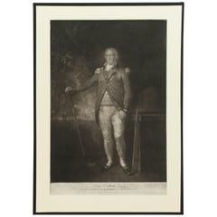
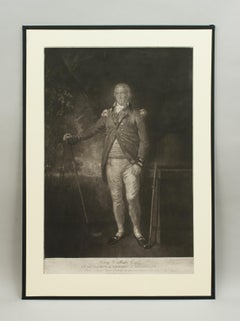
Located in Colorado Springs, CO
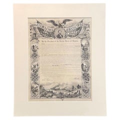
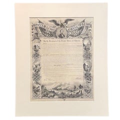
This is an 1844 engraving of President George Washington. The print was issued by G. Stuart in Albion, New York and engraved by H. S. Sadd. This standing portrait shows President George Washington in front of neoclassical columns. In his right hand, he holds a dress sword...
Category

1840s American Antique Jacques-Nicolas Bellin Prints

Materials

Paper

Engraving of a Map of Florida, the Gulf Coast, Caribbean & Central America, 1728
Located in Langweer, NL
This exceptional antique map, titled "Nouvelle Carte Marine de Toute les Cotes de l´Amerique" and alternatively known as "Nieuwe groote en seer Curieuse Paskaart van Geheel-WestIndie...
Category

Mid-18th Century European Antique Jacques-Nicolas Bellin Prints

Materials

Paper

Set Of Four Hand Colored Engravings Of Mushrooms
Located in Essex, MA
Each in a painted frame and all hand colored plate engravings with inscriptions in Latin and German.
Category

Mid-19th Century European Antique Jacques-Nicolas Bellin Prints

Materials

Glass, Paper

Antique Print of St. Cecilia, After Raphael, C.1850
By (after) Raphael (Raffaello Sanzio da Urbino)
Located in St Annes, Lancashire
Wonderful image after Raphael Fine Steel engraving. Published C.1850 Unframed.
Category

1850s English Baroque Antique Jacques-Nicolas Bellin Prints

Materials

Paper

Antique Print of St. Cecilia, After Raphael, C.1850
No Reserve
H 10 in W 6.25 in D 0.07 in
Antique Print of the City of Nanking 'China' by J. Van Schley, circa 1750
Located in Langweer, NL
This engraving is based on the sketches of Johan Niehof and published in Antonine de Prevost d' Exile's Histoire generale des voyages.     
Category

Mid-18th Century Antique Jacques-Nicolas Bellin Prints

Materials

Paper

17th Century Hand-Colored Map of West Africa by Mercator/Hondius
Located in Alamo, CA
A 17th century hand-colored map entitled "Guineae Nova Descriptio" by Gerard Mercator and Jodocus Hondius, published in their 'Atlas Minor' in Amsterdam in 1635. It is focused on the...
Category

Mid-17th Century Dutch Antique Jacques-Nicolas Bellin Prints

Materials

Paper

Rare Lynn Bogue Hunt Engraving of Ducks Unlimited, 1940
By Lynn Bogue Hunt
Located in Dallas, TX
Presenting a Rare Lynn Bogue Hunt engraving of ducks unlimited 1940. This piece cam from a wealthy estate in Dallas, TX with the mansion being built...
Category

Mid-20th Century American Sporting Art Jacques-Nicolas Bellin Prints

Materials

Paper

Original Antique Print of Owls circa 1835
Located in St Annes, Lancashire
Great image of owls presented in a distressed antique oak frame Lithograph after Cpt. Brown with original hand color. Published, circa.1835 .
Category

1830s English Folk Art Antique Jacques-Nicolas Bellin Prints

Materials

Oak, Paper

Set of 12 Original Antique Prints of the Crimean Wars, circa 1860
Located in St Annes, Lancashire
Great set of 12 military prints. All related to the Crimean Wars. Lithographs in original colors after William Simpson. Published by P & D Colna...
Category

1830s English Other Antique Jacques-Nicolas Bellin Prints

Materials

Paper

Original Antique Print of The Battle of Waterloo. Circa 1850
Located in St Annes, Lancashire
Great image of The Battle of Waterloo Fine steel engraving with a highly decorative border. Published by Tallis C.1850 Unframed. The size given is the paper size
Category

1850s English Antique Jacques-Nicolas Bellin Prints

Materials

Paper

Previously Available Items
Antique Print of the Island Brulante or Manam Motu Volcano, New Guinea, 1759
By Jacques-Nicolas Bellin
Located in Langweer, NL
Antique print titled 'Isle Brulante'. Old print of the volcano Island Brulante in the Indian Ocean near New Guinea, seen by William Dampiers on his voy...
Category

18th Century Antique Jacques-Nicolas Bellin Prints

Materials

Paper

Gulf of Mexico, Florida, C. America, Cuba, etc.: 18th C. Hand-colored Bellin Map
By Jacques-Nicolas Bellin
Located in Alamo, CA
This beautiful 18th century hand-colored map entitled "Carte du Golphe du Mexique et des Isles de L'Amerique" is by Jacques Nicolas Bellin, published in The Hague, Netherlands by Ant...
Category

Mid-18th Century French Antique Jacques-Nicolas Bellin Prints

Materials

Paper

Antique Map of Celebes 'Sulawesi', Indonesia, 1757
By Jacques-Nicolas Bellin
Located in Langweer, NL
Antique map titled 'Carte De L'Isle Celebes ou Macassar'. Detailed copper engraved map of Celebes (Sulawesi, Indonesia), showing Makassar, which was the most important trading city o...
Category

18th Century Antique Jacques-Nicolas Bellin Prints

Materials

Paper

Bellin 18th Century Hand Colored Map of St. Christophe (St. Kitts)
By Jacques-Nicolas Bellin
Located in Alamo, CA
Jacques Bellin's hand colored copper plate map of the Caribbean island of Saint Kitts entitled "Carte de de L'isle St. Christophe", published in Paris in 1780 in Prevost's "L'Histoir...
Category

Mid-18th Century French Antique Jacques-Nicolas Bellin Prints

Materials

Paper

Bellin 18th Century Hand Colored Map of "L'isle de Sainte Lucie" 'St. Lucia'
By Jacques-Nicolas Bellin
Located in Alamo, CA
Jacques Bellin's map of the Caribbean island of Saint Lucia entitled "Carte de L'isle de Sainte Lucie", published in Paris in 1764. The West Indies island of Saint Lucia is part o...
Category

Mid-18th Century French Antique Jacques-Nicolas Bellin Prints

Materials

Paper

Antique Map of the Petit-Goave Region of Haiti by J.N. Bellin, 1764
By Jacques-Nicolas Bellin
Located in Langweer, NL
Antique map titled 'Plan de la Rade et Ville du Petit Goave'. Beautiful hand-colored map of the Petit-Goave region of Haiti from Bellin's "Le Petit Atlas Maritime, ou Recueil de Cart...
Category

Mid-18th Century Antique Jacques-Nicolas Bellin Prints

Materials

Paper

Jacques-nicolas Bellin prints for sale on 1stDibs.

Jacques-Nicolas Bellin prints are available for sale on 1stDibs. These distinctive items are frequently made of paper and are designed with extraordinary care. There are many options to choose from in our collection of Jacques-Nicolas Bellin prints, although beige editions of this piece are particularly popular. Many of the original prints by Jacques-Nicolas Bellin were created in the Georgian style in europe during the 18th century and earlier. If you’re looking for additional options, many customers also consider prints by Prevost, Francois Nicolas Martinet, Brodtmann, and K.J.A.. Prices for Jacques-Nicolas Bellin prints can differ depending upon size, time period and other attributes — on 1stDibs, these items begin at $66 and can go as high as $775, while a piece like these, on average, fetch $270.

Creators Similar to Jacques-Nicolas Bellin

Recently Viewed

View All