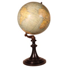
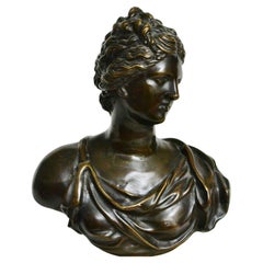
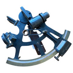
Terrestrial Globe By G. Thomas Paris
Located in Brussels, Brussels
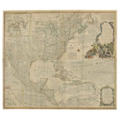
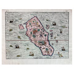
can find the maritime currents, navigation lines, depth of the seas and heights of the mountains The
Category
19th Century French Napoleon III Antique Navigation
Materials
Wood
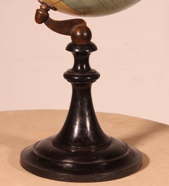
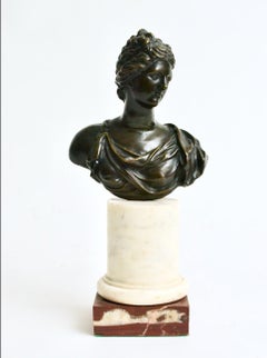
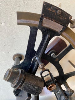
Terrestrial Globe By G. Thomas Paris
Located in Brussels, Brussels
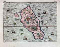
can find the maritime currents, navigation lines, depth of the seas and heights of the mountains The
Wood
$239Sale Price|20% Off
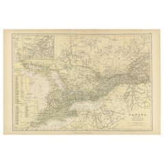
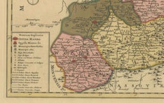
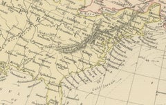
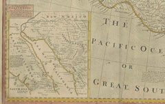
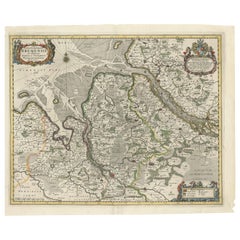
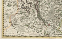
Antique Map of Canada, The Province of Ontario and Part of Quebec, 1882
Located in Langweer, NL
River, a key navigational route, reflects its importance for trade and movement between the Great Lakes
Paper
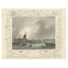
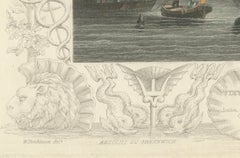
1828 Aquatint Panorama of Greenwich with Iconic Windmill
Located in Langweer, NL
Royal Observatory and a key point for maritime navigation. The windmill, a symbol of the area’s
Paper
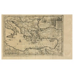
Venetian Trade Routes in the Levant – Antique Map by Pieter van der Aa, ca.1720
Located in Langweer, NL
featured, emphasizing their importance as trading hubs. The Aegean islands, critical for navigation and
Paper
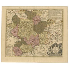
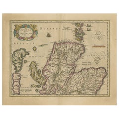
Hand-Colored Map of Westphalia – Copper Engraving by Ottens, Amsterdam c.1720
Located in Langweer, NL
richness. Beneath them sits a finely engraved mileage scale, providing reference points for navigation and
Paper
$923Sale Price|20% Off
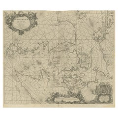
Nautical Chart of Skagerrak and Øresund by Johannes van Keulen, 1680
Located in Langweer, NL
Øresund straits. These strategic waterways were critical for European maritime navigation, as they
Paper
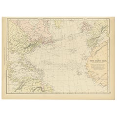
1882 Map of the North Atlantic Ocean Showing Cable Tracks and Trade Winds
Located in Langweer, NL
navigation. The map also includes subtle pastel coloring to delineate political boundaries and territories
Paper
Dutch Print “Description Du Blaisois” In Italian Frame With Mirrors
Located in Prato, Tuscany
Contractus, Valck and Schenk produced numerous city views, navigation charts, and globes. Their maps were not
Paper
$2,450Sale Price|24% Off
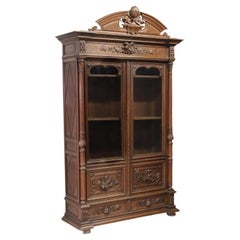
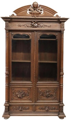
1800's Antique Library, French, Carved Oak, Glazed Doors Bookcase!
Located in Austin, TX
carved oak bookcase, late 19th c., having split pediment, centering globe and navigational tools, dual
Wood, Oak
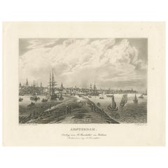
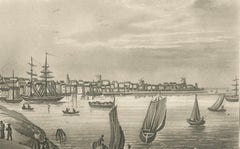
View of Amsterdam from the Water with Sailing Ships, Baedeker, circa 1850
Located in Langweer, NL
character, emphasizing Amsterdam’s historical role as a center of global trade and navigation. Drawn by W
Paper
$1,442Sale Price|20% Off
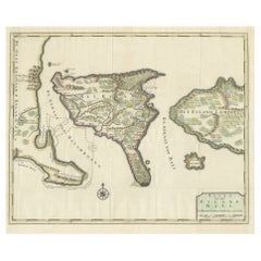
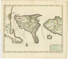
1726 Valentyn's Map of Bali and Lombok, Original Engraving
Located in Langweer, NL
, mountainous regions. It also features depth soundings around the coast, suggesting it was used for navigation
Paper
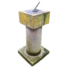
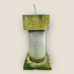
Historic Crimean War Sundial from Kinburn Fort - Stone Garden Sculpture
Located in King's Lynn, GB
secondary role in navigation and astronomical observations, aiding in understanding tides and daylight hours
Stone, Slate
18th century Venus de’ Medici Bronze Bust
Located in Stockholm, SE
navigation points by which the progress of the Western classical tradition is traced, the references to it
Marble, Bronze
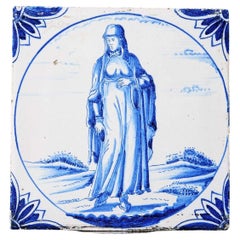
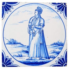
Antique Ravesteijn Delft Tile of Woman in Turkish Dress
By Delft
Located in Wormelow, Herefordshire
century Ottoman life, taken from the Dutch translation of the book 'Navigations et pérégrinations
Clay
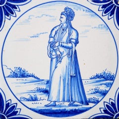
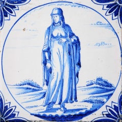
Reclaimed Ravesteijn Delft Tile of a Persian Lady
By Delft
Located in Wormelow, Herefordshire
'Navigations et pérégrinations orientales' by Nicolas de Nicolay, published in Lyons in 1568. A print of
Clay
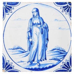
19th Century Ravesteijn Delft Tile of a Turkish Woman
By Delft
Located in Wormelow, Herefordshire
century Ottoman life, taken from the Dutch translation of the book 'Navigations et pérégrinations
Clay
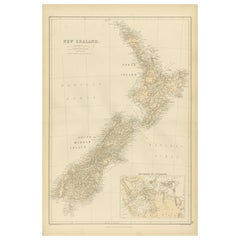
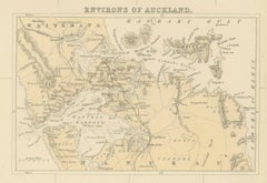
1882 Original Antique Map of New Zealand with Inset of Auckland's Environs
Located in Langweer, NL
navigation points and surrounding islands, are also shown. An inset map of the "Environs of Auckland" offers
Paper
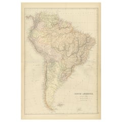
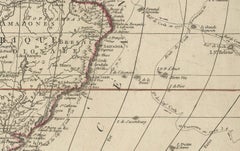
1882 Detailed Map of South America showing Political and Geographical Features
Located in Langweer, NL
identification of territorial boundaries. Maritime features, including oceanic depths and coastal navigation
Paper
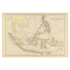
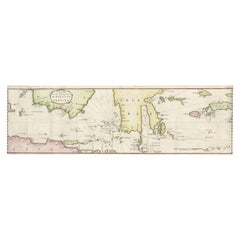
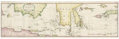
1882 Antique Map of Indian Archipelago, Southeast Asia, Blackie & Son
Located in Langweer, NL
, are prominently included, reflecting the region's importance for trade and navigation during the 19th
Paper
Hand-Colored City Plan of Cologne by Nicolas de Fer, 1705
Located in Langweer, NL
navigation insight but also enhances the visual charm of the map. The detailed representation of churches
Paper
$124Sale Price|20% Off
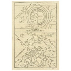
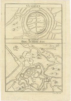
Map of Vusihyen, Hu Chew Fu and Hou-Tcheou-Fou, Historical Chinese Cities, 1754
Located in Langweer, NL
the scientific rigor of the time but also the French government's commitment to navigation
Paper
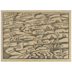
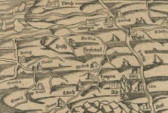
Rare 16th Century Woodcut Map of Brabant and the Rhine Valley, circa 1549
Located in Langweer, NL
this style were not made for navigation but for illustrating the relative positions of cities, rivers
Paper
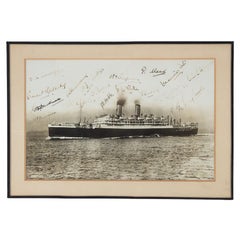

A Team-Signed Gelatin Print Photograph of the R.M.S. Otranto
Located in Lymington, Hampshire
. Otranto, operated by the Orient Line (Orient Steam Navigation Company) and of one of England’s most
Paper
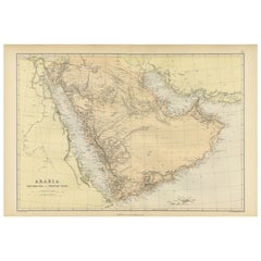

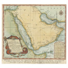
Original 1882 Map of Arabia, Red Sea & Persian Gulf
Located in Langweer, NL
significant for navigation and commerce. The map includes nautical lines indicating sea depths and shipping
Paper
$1,199
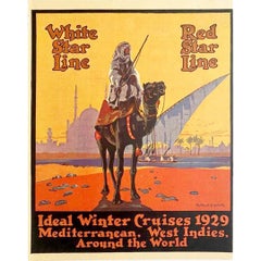
1929 Original Poster - White star line Red star line Ideal Winter cruises
Located in PARIS, FR
Star Line is a former shipping company that chartered liners owned by the International Navigation
Paper, Lithograph
$2,302Sale Price|20% Off
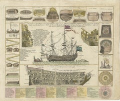
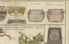
Detailed 1730 Maritime Warship Print with Tools, Rigging, and Ship Cross-Section
Located in Langweer, NL
navigational instruments such as a compass and a "quinoctial compass." The bottom of the print includes an
Paper
$2,217Sale Price|20% Off
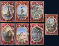
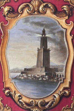
Set of 7 Original Paintings - The Seven Wonders of the Ancient World Classical
Located in Cirencester, Gloucestershire
all that followed and demonstrated the Ptolemaic dynasty’s commitment to science and navigation.
Oil
$278Sale Price|20% Off
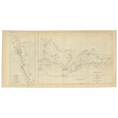
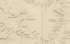
Charting the West: Surveyor General Roe’s Western Australian Expedition , 1852
Located in Langweer, NL
animal species, and insights into the navigation and surveying techniques of the time. Roe's work was
Paper
$594Sale Price|20% Off
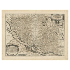
Mapping Stormarn: Johannes Meier's 1650 Cartographic Masterpiece
Located in Langweer, NL
era, often designed for inclusion in atlases or books. This map is not only a navigational and
Paper
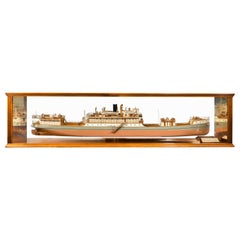
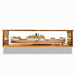
Cased Ship’s Boardroom Model of Three Sister Ships
Located in Lymington, Hampshire
the Argentine Navigation Co. (Nicolas Mihanovich) Ltd. London & Buenos Aires,” the model finely
Glass, Wood
$345Sale Price|20% Off
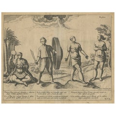
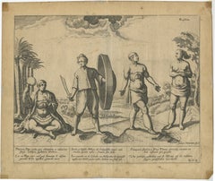
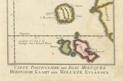
Natives from Pegu, the Moluccan Islands, Penequais Indians and St Thomas, c.1605
Located in Langweer, NL
Itinerario. This work informed Europeans of the 16th century Portuguese trade and navigation in southern Asia
Paper
$354Sale Price|20% Off
Title-Page to a Book of Prospects of London, Published by R. Butter (1785-1799)
Located in Langweer, NL
Cathedral. The Thames teems with ships, emphasizing London’s importance as a center of trade and navigation
Paper
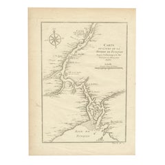
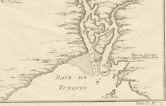
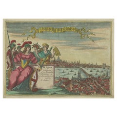
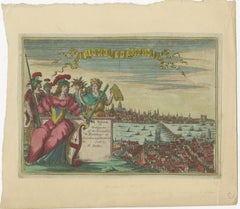
1750 Bellin Map of the Red River (Tonkin River) and Hanoi, Vietnam
Located in Langweer, NL
Tonkin, labeled as Baye de Tunquin. Bellin’s work was based on navigational surveys by an English
Paper
$191Sale Price|20% Off
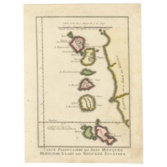
Old Map of the Spice Islands, Moluccas by Bellin, Published in 1771
Located in Langweer, NL
bar in both French and Dutch nautical miles demonstrates the map’s practical use for navigation. The
Paper
$2,244Sale Price|20% Off
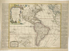
Detailed 1795 Map of the Americas with Exploration Tracks and Nice Cartouche
Located in Langweer, NL
interest in navigation, commerce, and the scientific exploration of new territories. The inclusion of
Paper
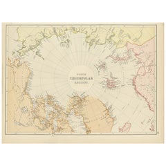

Arctic Exploration – Greenland & North Circumpolar Regions Map, 1882
Located in Langweer, NL
purposes both educational and navigational, capturing the extent of polar exploration at the time. Names of
Paper

Antique Map of New Ireland (Pacific) with Coastal Profiles – Cook Voyages, 1774
Located in Langweer, NL
prominent capes and islands encountered during Pacific navigation. Such profile views were an essential
Paper
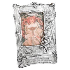
Edwardian Sterling Silver Photograph Frame in Art Nouveau Style
By Charles S. Green & Co.
Located in Jesmond, Newcastle Upon Tyne
of the Onondaga tribe. He taught navigation, medicine, arts and agriculture and has been featured in
Sterling Silver
$853Sale Price|20% Off
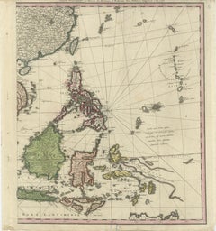
Rare Chart of Indonesia Including Borneo, Java, Celebes, Ceram and More, 1779
Located in Langweer, NL
Antique map titled 'Carte de la Navigation de Batavia a Amboina'. Rare chart of Indonesia
Paper
$844Sale Price|20% Off
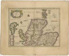
Original Antique Map of the Northern Part of Scotland, circa 1640
Located in Langweer, NL
map not only serves as a navigational aid but also provides a fascinating glimpse into the artistic
Paper
Rare Antique Wall-Map of North America: French and Indian War Boundaries, 1793
Located in Langweer, NL
, portages, Indian villages, and tribal territories. It also highlights routes of navigation in the Gulf of
Paper
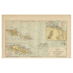
Map of Samoa or Schiffer-Inseln (Navigator Islands) - 19th Century German Map
Located in Langweer, NL
barriers to navigation around the islands. Historical Context: During the 19th century, Samoa became a
Paper
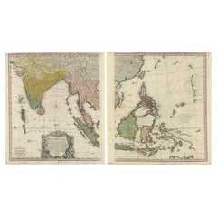
1748 Homann Heirs Double Map of the East Indies and Southeast Asia
Located in Langweer, NL
maritime navigation, detailing the Philippines, Borneo, Java, and the surrounding islands. Together, the
Paper

$575Sale Price|20% Off
Exquisite 1580 Ortelius Map of the Narbonne Coastal Region, France
Located in Langweer, NL
historical region. The artwork includes a visually appealing title cartouche, a navigational compass, and a
Paper

Map of the World: An Original 18th Century Hand-colored Map by E. Bowen
Located in Alamo, CA
. This projection has the advantage of preserving angles and shapes, making it useful for navigation. The
Engraving
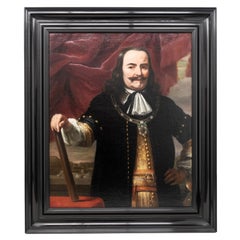
Portrait of Lieutenant Admiral Michiel Adriaensz. de Ruyter by Ferdinand Bol
By Rembrandt van Rijn
Located in ZWIJNDRECHT, NL
a table covered in a red cloth. Some objects on the table are related to navigation on the sea, such
Paint
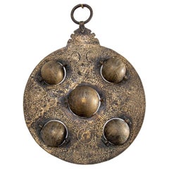
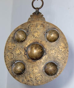
Islamic Cast Bronze Astrolabe with Five Celestial Globes Astronomical Instrument
Located in Moreno Valley, CA
as hand-held representations of the cosmos, used for astronomy, timekeeping, navigation, and
Brass, Bronze
$2,158
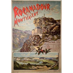
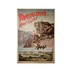
Poster by Hugo d'Alésie Rocamadour et Montvalent Chemin de fer d'Orléans
Located in PARIS, FR
posters for navigation companies, automobile manufacturers, and even etchings capturing the essence of
Linen, Paper, Lithograph
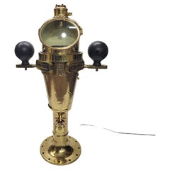
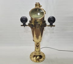
World War I US Navy Ships Binnacle
Located in Norwell, MA
plate is marked type VII no 1200, Bureau of Navigation, US Navy and dated 1918. This is an outstanding
Brass
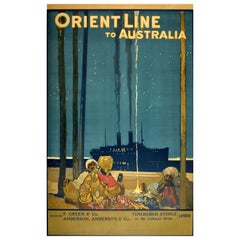
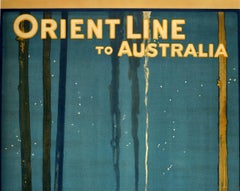
Original Antique Poster Orient Line To Australia Ocean Liner Cruise Travel Art
By Elijah Albert Cox
Located in London, GB
Orient Steam Navigation Company (known as Orient Line) was a British shipping company that merged to form
Paper
$450Sale Price|20% Off
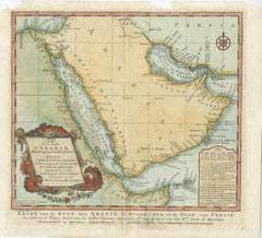
Original Antique Map of Arabia and the Red Sea, circa 1750
Located in Langweer, NL
coastlines and the interior is primarily left blank. The shoals and navigational hazards in the Red Sea and
Paper
U.S. Navy Steel and Brass Quadrant, First Half of the 20th Century
Located in Nantucket, MA
, in very good condition with lenses, shades and scale. The essential mariner's navigational device and
Brass, Steel
$534Sale Price|19% Off
Johannes Janssonius' 17th-Century Map of the Duchy of Bremen in Germany
Located in Langweer, NL
trade and navigation. It extends from the island of Wangeroog to Cloppenburg and Verden, encompassing a
Paper
1606 Hand-Colored Woodcut Map of Sumatra from Ramusio’s Delle Navigationi
Located in Langweer, NL
17th century, emphasizing its importance in the spice trade and maritime navigation. Condition: The
Paper
Waltham Sterling Silver Trench Watch circa 1914 Rare P.S. Bartlett Half Hunter
By Waltham
Located in Long Beach, CA
and the Korean war they designed timers, navigational devices, automobiles, aviation and nautical
Sterling Silver
$1,093Sale Price|20% Off
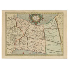
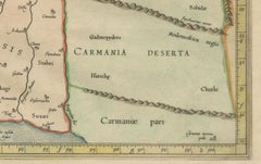
Mercator's Ptolemaic Map of Ancient Assyria, Media, and Persia
Located in Langweer, NL
lines, significantly simplifying navigation. This projection, which shows parallels and meridians at
Paper
$1,381Sale Price|20% Off
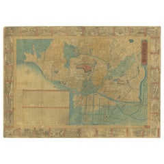
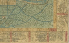
1885 Shinsen Tokyo Zenzu: Rare Meiji-Era Map of Tokyo by Sakai Kinzaburo
Located in Langweer, NL
not only decorative but also functional, possibly intended for administrative or navigational purposes
Paper