Items Similar to Antique Map of Canada, The Province of Ontario and Part of Quebec, 1882


Want more images or videos?
Request additional images or videos from the seller
1 of 6
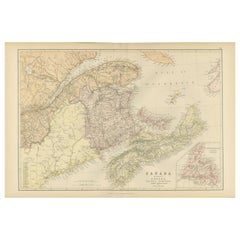
Antique Map of Canada, The Province of Ontario and Part of Quebec, 1882
About the Item
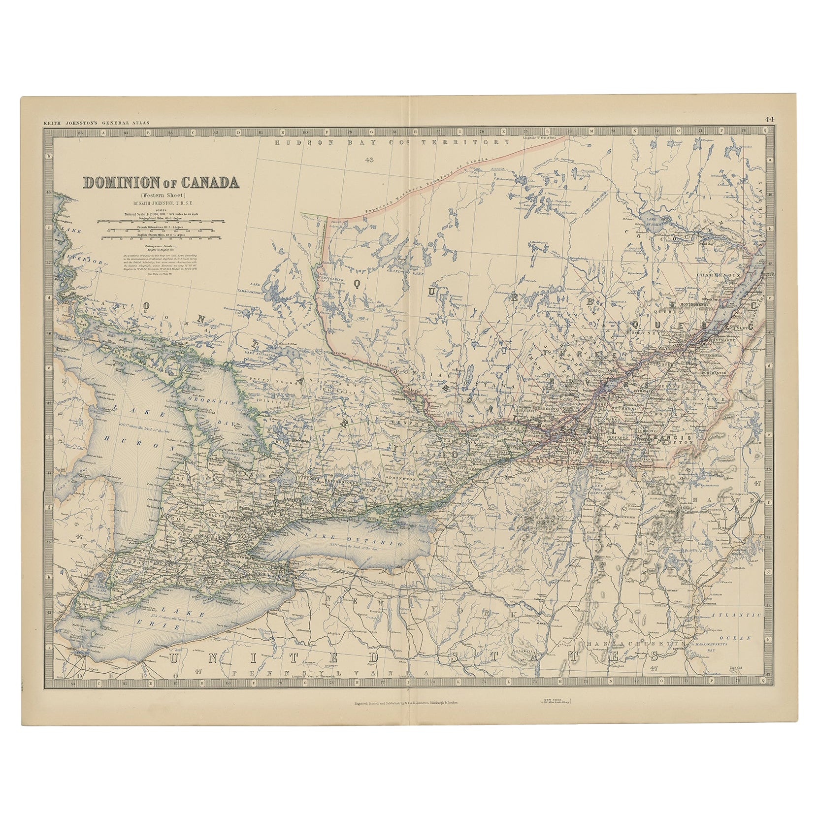
This is a historical map from the 1882 Blackie Atlas, this time detailing "The Province of Ontario, and Part of Quebec" in Canada. The map presents a detailed illustration of Ontario, highlighting its dense network of rivers, lakes, and settlements, as well as the intricate railway systems that were vital for communication and transportation during that period.
The map features Lake Ontario prominently and includes the bordering areas of Quebec. This suggests an emphasis on the interconnectedness of these regions, both geographically and economically, during the time. The inclusion of the St. Lawrence River, a key navigational route, reflects its importance for trade and movement between the Great Lakes and the Atlantic Ocean.
An inset in the top left corner provides a more detailed street map of the city of Montreal, indicating the city's importance as a hub during the late 19th century. The detail in this inset suggests that Montreal was a significant urban center worth separate consideration from the larger provincial map.
The map's legend, likely located on the left side, probably lists the towns and various geographical features, such as counties, in Ontario. The hachures indicate the relief and show the varied terrain of Ontario and part of Quebec. As with other maps from the era, the scale and longitude and latitude markers are indicative of the map's utility for navigation and education. The precision of the mapmaking suggests a high level of cartographic skill and a commitment to detail.
- Dimensions:Height: 14.97 in (38 cm)Width: 22.45 in (57 cm)Depth: 0 in (0.02 mm)
- Materials and Techniques:
- Period:
- Date of Manufacture:1882
- Condition:Good condition, folding line in the middle. The outer borders are slightly discolored due to age, but not the image. Study the image carefully.
- Seller Location:Langweer, NL
- Reference Number:
About the Seller
5.0
Platinum Seller
These expertly vetted sellers are 1stDibs' most experienced sellers and are rated highest by our customers.
Established in 2009
1stDibs seller since 2017
1,928 sales on 1stDibs
Typical response time: <1 hour
- ShippingRetrieving quote...Ships From: Langweer, Netherlands
- Return PolicyA return for this item may be initiated within 14 days of delivery.
More From This SellerView All
- Old Original Antique Map of Western Canada, 1882Located in Langweer, NLAntique map titled 'Dominion of Canada'. Old map of Western Canada. This map originates from 'The Royal Atlas of Modern Geography, Exhibiting, in a ...Category
Antique 1880s Maps
MaterialsPaper
- Antique Map of South America, Southern Part, 1882Located in Langweer, NLAntique map titled 'South America'. Old map of South America. This map originates from 'The Royal Atlas of Modern Geography, Exhibiting, in a Series of Entirely Original and Authenti...Category
Antique 19th Century Maps
MaterialsPaper
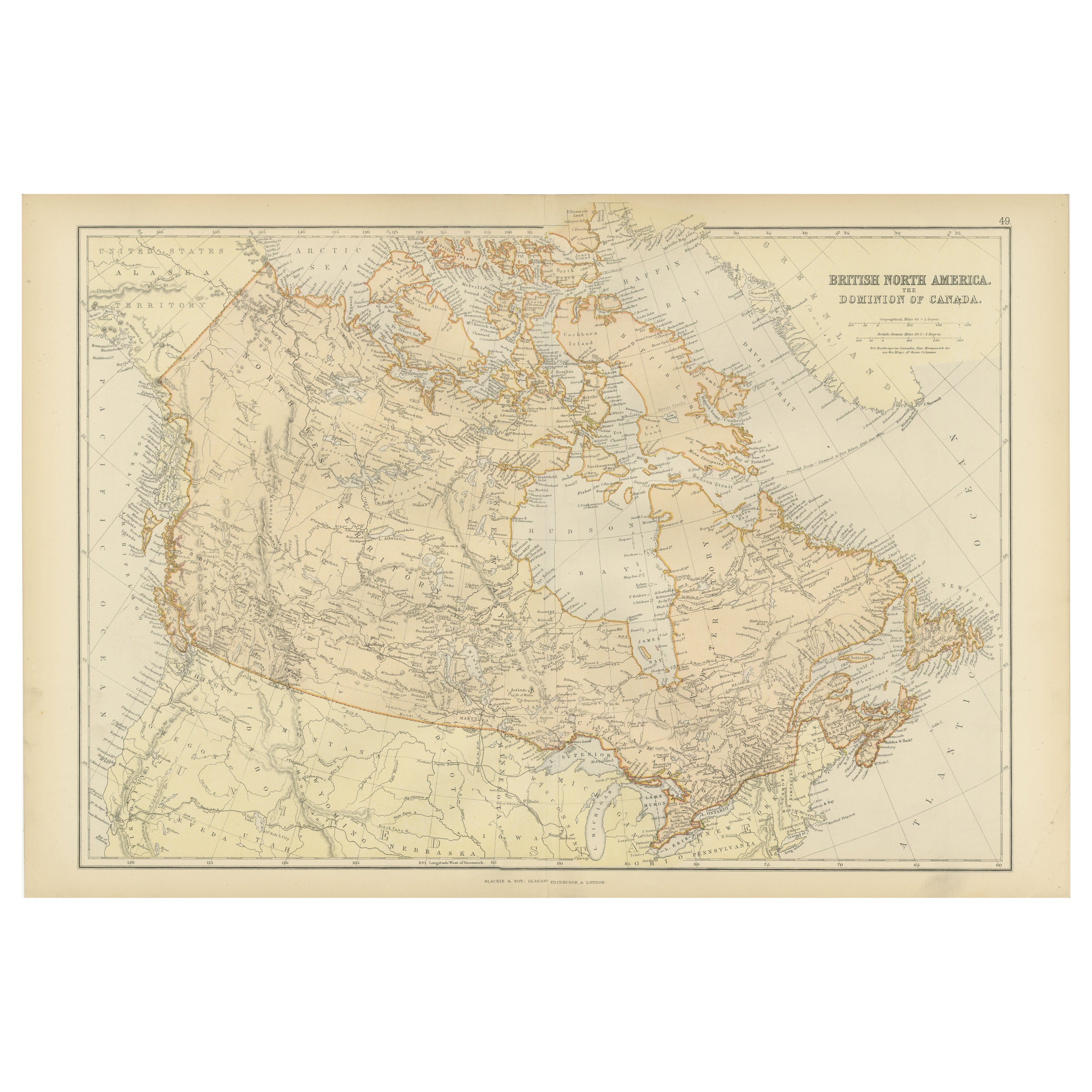
- Antique Map of British North America, The Dominion of of Canada, 1882Located in Langweer, NLThis map is titled "British North America, Dominion of Canada," from the 1882 Blackie Atlas. It features the geographical area that comprises modern-day Canada, with notable features...Category
Antique 1880s Maps
MaterialsPaper
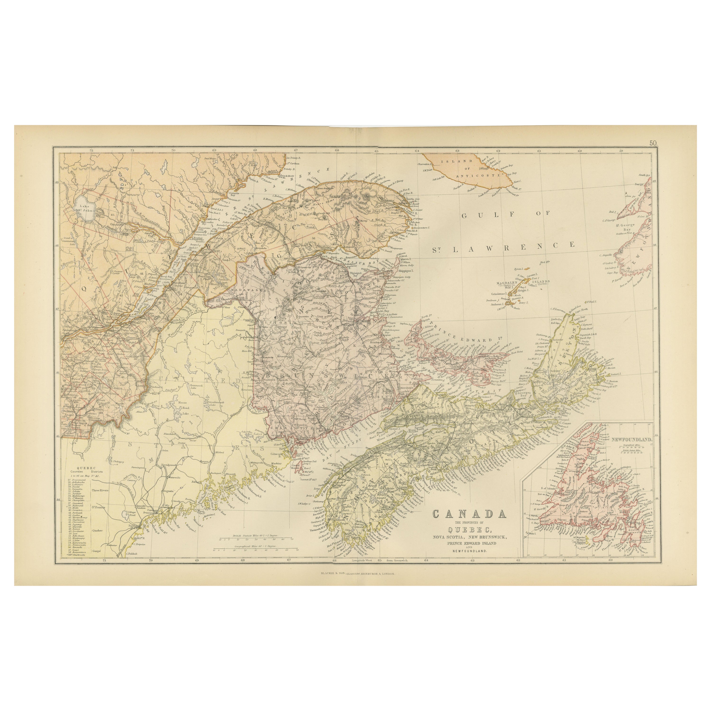
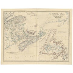
- Decorative Antique Map of Eastern Canada, Published in 1882Located in Langweer, NLThis is a historical map from the 1882 Blackie Atlas, focused on eastern Canada and the maritime provinces. The map is titled "Canada. No. 2. Provinces of Nova Scotia, New Brunswick,...Category
Antique 1880s Maps
MaterialsPaper
- Antique Map of the Province of Canada 'East' by A.K. Johnston, 1865Located in Langweer, NLAntique map titled 'Province of Canada (Eastern Sheet)'. Depicting New Brunswick, Newfoundland, Cape Breton Island, Prince Edward Island, Nova Scotia and m...Category
Antique Mid-19th Century Maps
MaterialsPaper
- Antique Map of Eastern Canada with an inset Map of Newfoundland, 1882Located in Langweer, NLAntique map titled 'Dominion of Canada'. Old map of Eastern Canada with an inset map of Newfoundland. This map originates from 'The Royal Atlas of Modern Geography, Exhibiting, in a ...Category
Antique 19th Century Maps
MaterialsPaper


You May Also Like
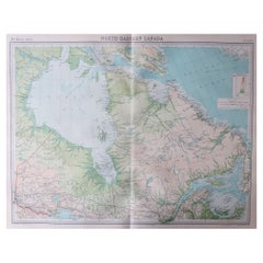
- Large Original Vintage Map of Quebec & Ontario, Canada, circa 1920Located in St Annes, LancashireGreat map of Quebec and Ontario. Unframed Original color By John Bartholomew and Co. Edinburgh Geographical Institute Published, circa 1920 ...Category
Vintage 1920s British Maps
MaterialsPaper
- Antique 18th Century Map of the Province of Pensilvania 'Pennsylvania State'Located in Philadelphia, PAA fine antique of the colony of Pennsylvania. Noted at the top of the sheet as a 'Map of the province of Pensilvania'. This undated and anonymous map is thought to be from the Gentleman's Magazine, London, circa 1775, although the general appearance could date it to the 1760's. The southern boundary reflects the Mason-Dixon survey (1768), the western boundary is placed just west of Pittsburgh, and the northern boundary is not marked. The map has a number of reference points that likely refer to companion text and appear to be connected to boundaries. The western and southern boundaries are marked Q, R, S, for example. A diagonal line runs from the Susquehanna R to the Lake Erie P. A broken line marked by many letters A, B, N, O, etc., appears in the east. There are no latitude or longitude markings, blank verso. Framed in a shaped contemporary gilt wooden frame and matted under a cream colored matte. Bearing an old Graham Arader Gallery...Category
Antique 18th Century British American Colonial Maps
MaterialsPaper
- Original Antique Map of Canada, Arrowsmith, 1820Located in St Annes, LancashireGreat map of Canada. Drawn under the direction of Arrowsmith. Copper-plate engraving. Published by Longman, Hurst, Rees, Orme and Brown, 1820 ...Category
Antique 1820s English Maps
MaterialsPaper
- Map of the Kingdom of Sardinia and Part of the Kingdom of Genoa, RomeBy Giovanni Maria CassiniLocated in Hamilton, Ontario18th century map by Italian engraver Giovanni Maria Cassini (Italy 1745-1824). Map of Part of the Kingdom of Sardinia and Part of the Kingdom of Genoa: Rome. This is a hand colored a...Category
Antique 18th Century Italian Maps
MaterialsPaper
- 1863 "Lloyd's New Map of the United States, the Canadas, and New Brunswick"Located in Colorado Springs, COPresented is “Lloyd's New Map of the United States, the Canadas and New Brunswick, From the latest Surveys, Showing Every Railroad & Station Finished to June 1863, and the Atlantic and Gulf Coasts.” A large, Civil War-era hanging map of the United States and adjacent territories, this map covers the area from the Atlantic Ocean and extends as far west as the 103 meridian, to “Dacotah,” Nebraska, Kansas, "Indian Territory," and Texas. The southern continuation of Florida is shown in an inset map along the right margin. This map was published by J. T. Lloyd, in New York, in 1863. According to the publisher’s marking at lower right, this map was originally issued in two states: "in Sheets, Colored" for 50 cents, and "Varnished nicely, with Rollers" for $1. Throughout the map, the counties are colored and the towns and cities well labeled. A reference key in the bottom margin provides symbols for railroads, turnpikes and wagon roads, state capitals, cities and towns, and village post offices. As emphasized in the map’s title, this map is especially notable for the countless railway lines and stations depicted, with distances noted between points, listing “every railroad and finished station to June 1863.” Additionally, two shipping agents and their routes are drawn out of New York City. The map includes details of the steamship routes into New York and Philadelphia from Liverpool and on to California and Oregon via an overland Nicaraguan trek, presumably to assist gold rush emigrants. This expansive and impressive map depicts the eastern half of the United States in the third year of the Civil War. In order not to recognize the legitimacy of the Confederate States of America, each state is shown in the same manner as the Union states. The only indication that the American Civil War was in progress when this map was published is a printed notice that Gideon Wells, Secretary of the Navy, wishes to acquire a quote on 100 copies of Lloyd’s Mississippi River map...Category
Antique 1860s American Maps
MaterialsLinen, Wood, Paper
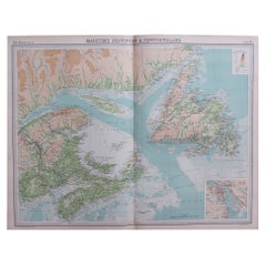
- Large Original Vintage Map of the Maritimes, Canada, circa 1920Located in St Annes, LancashireGreat map of The Maritime provinces Unframed Original color By John Bartholomew and Co. Edinburgh Geographical Institute Published, circa 1920 Free shipping.Category
Vintage 1920s British Maps
MaterialsPaper