Items Similar to Map of Vusihyen, Hu Chew Fu and Hou-Tcheou-Fou, Historical Chinese Cities, 1754


Want more images or videos?
Request additional images or videos from the seller
1 of 6
Map of Vusihyen, Hu Chew Fu and Hou-Tcheou-Fou, Historical Chinese Cities, 1754
About the Item
Given these specific names—Vusihyen, Hu Chew Fu, and Hou-Tcheou-Fou—it appears that the map depicts historical Chinese locations. These names are likely transliterations of Chinese names from the period. "Hu Chew Fu" might be an old Western spelling for what is known in modern pinyin as Huzhou, a city near Lake Tai in China. "Hou-Tcheou-Fou" could refer to a historical name for another city or region, also located in China.
More research needed.
More about the maker:
Jacques-Nicolas Bellin's contributions to cartography and hydrography set a precedent in mapmaking during the 18th century. His role as Hydrographer to the French Navy and later as the Official Hydrographer to the French King placed him at the forefront of maritime charting and exploration. The detail and accuracy of Bellin's maps reflected not only the scientific rigor of the time but also the French government's commitment to navigation, exploration, and colonial expansion.
His work on the "Neptune Francois," "Atlas Maritime," and "Hydrographie Francaise," among other important collections, helped to improve the accuracy of sea navigation and fostered a greater understanding of the world's geography. The fact that his maps were widely republished and copied is a testament to their value and the respect he commanded across Europe.
Bellin's smaller format maps, like those in the "Petit Atlas Maritime," and his contributions to Prévost's "Histoire Generale des Voyages," were invaluable to navigators, explorers, and scholars. His influence was such that it not only advanced French cartography but also the European cartographic tradition as a whole, leaving a legacy that would endure well beyond his lifetime.
- Dimensions:Height: 9.97 in (25.3 cm)Width: 7.05 in (17.9 cm)Depth: 0 in (0.02 mm)
- Materials and Techniques:Paper,Engraved
- Period:1750-1759
- Date of Manufacture:1754
- Condition:Good. General age-related toning and/or occasional minor defects from handling. Please study scan carefully.
- Seller Location:Langweer, NL
- Reference Number:
About the Seller
5.0
Platinum Seller
These expertly vetted sellers are 1stDibs' most experienced sellers and are rated highest by our customers.
Established in 2009
1stDibs seller since 2017
1,928 sales on 1stDibs
Typical response time: <1 hour
- ShippingRetrieving quote...Ships From: Langweer, Netherlands
- Return PolicyA return for this item may be initiated within 14 days of delivery.
More From This SellerView All
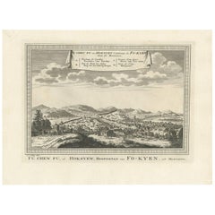
- Antique Print of Fu Chew Fu 'Hoksywe, China' by J. van Schley, circa 1750Located in Langweer, NLAntique print, titled 'Fu Che Fu ou Hoksyeu capitale de Fo-Kyen' - Decorative panoramic view of Fu Chew Fu, or Hoksywe, capital of Fo-Kyen. This print originates from Prevost's 'Hist...Category
Antique Mid-18th Century Prints
MaterialsPaper
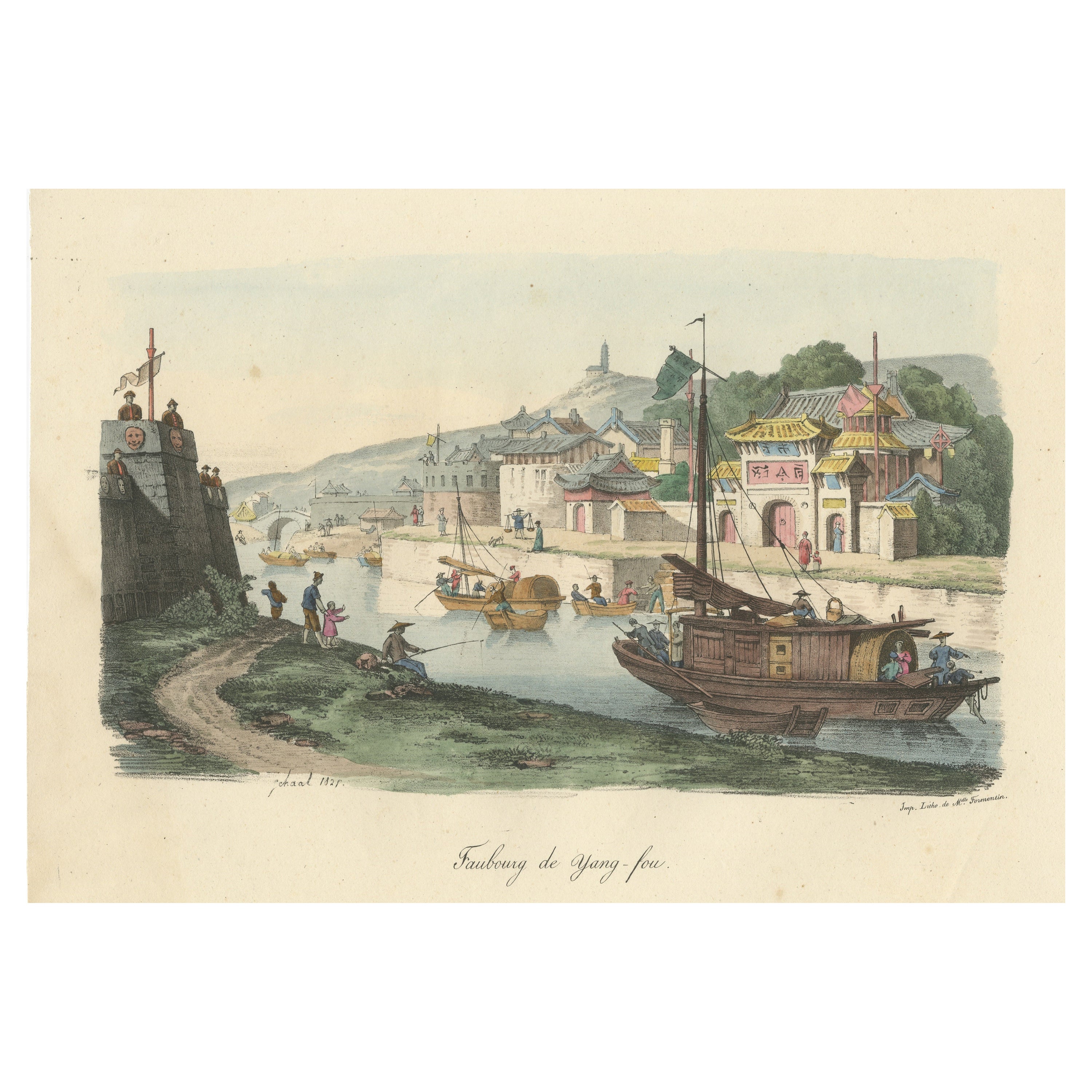
- Original Antique Print of the city of Yang-Tcheou, ChinaLocated in Langweer, NLAntique print titled 'Faubourg de Yang-fou'. Original old print of the city of Yang-tcheou, in the Province of Che-kian, showing a temple, a monument, a fort, and part of the city wa...Category
Antique Mid-19th Century Prints
MaterialsPaper
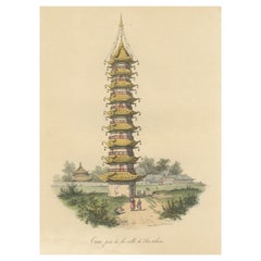
- Antique Print of a Chinese Taa Near Sou-TcheouLocated in Langweer, NLAntique print titled 'Taa, près de la ville de Sou-tcheou'. Original old print of a Chinese taa near Sou-Tcheou. A taa is a kind of pagoda. This print originates from 'La Chine, moeu...Category
Antique Mid-19th Century Prints
MaterialsPaper
- Antique Map of London by Tirion '1754'Located in Langweer, NLAntique map titled 'Kaart van Londen enz. en van het naby gelegen land ruim een Uur gaans rondsom dezelve Stad; getrokken uit de groote gemeeten Kaart van Hr. John Rocque'. In the se...Category
Antique Mid-18th Century Maps
MaterialsPaper
- Antique Map of Siberia by Bellin, 1754Located in Langweer, NLAntique map titled 'Carte de la Siberie'. Detailed map of Siberia, extending from the White Sea and the Caspian Sea in the west to Irkuckoi Province, Jakutky on the Lena River and regions just to the east. Centered on the Jenisi River. Originates from Prévost's 'Histoire Générale des Voyages'. Artists and Engravers: Jacques-Nicolas Bellin (1703-1772) was among the most important mapmakers of the eighteenth century. In 1721, at age 18, he was appointed hydrographer (chief cartographer) to the French Navy. In August 1741, he became the first Ingénieur de la Marine of the Depot des cartes...Category
Antique 18th Century Maps
MaterialsPaper
- Antique Map of France with the English Channels, 1754Located in Langweer, NLAntique map France titled 'An Accurate Map of France drawn from the best authorities'. Small, detailed map of France. With decorative title cartouche. Ar...Category
Antique 18th Century Maps
MaterialsPaper


You May Also Like
- A Series of Historical Maps of Italian CitiesLocated in New York, NYVintage maps can add so much interest to a space and this group of Italian maps is particularly interesting. Each is a charming reinterpretation of historical city maps (Rome, Venic...Category
20th Century Italian Prints
MaterialsPaper
- Vintage Poster Historical Construction Gothic Dome Medieval City Historical SiteLocated in Berghuelen, DEThe double sided poster shows the construction of a Gothic dome and on the backside the view inside a medival city. Colorful print on paper. Measur...Category
Mid-20th Century German Country Prints
MaterialsPaper
- Original Antique Map of China, Arrowsmith, 1820Located in St Annes, LancashireGreat map of China Drawn under the direction of Arrowsmith Copper-plate engraving Published by Longman, Hurst, Rees, Orme and Brown, 1820 Unfr...Category
Antique 1820s English Maps
MaterialsPaper
- Framed Early 19th Century Drawn and Engraved Map of ChinaBy John Knighton ThomsonLocated in San Francisco, CAHand drawn and tinted engraved map of China dated 1815 Created for Thomson's New General Atlas Edinburgh Beautifully framed with a linen covered mat.Category
Antique Early 19th Century European Prints
MaterialsPaper
- Large Vintage France Map, Continental, Historical Cartography, Late 20th CenturyLocated in Hele, Devon, GBThis is a large vintage map of France. A Continental, framed example of historical cartography, dating to the late 20th century, circa 1970. Fas...Category
Late 20th Century European Mid-Century Modern Prints
MaterialsGlass, Wood, Paper
- Original Antique Map / City Plan of Brussels by Tallis, circa 1850Located in St Annes, LancashireGreat map of Brussels. Steel engraving. Published by London Printing & Publishing Co. (Formerly Tallis), C.1850 Free shipping.Category
Antique 1850s English Maps
MaterialsPaper