
Cambridge Map

Cambridge Map, Original Vintage Poster by Kerry Lee

Cambridge Map, Original Vintage Poster by Kerry Lee

By Kerry Lee

Located in London, GB

Kerry Lee (1903 - 1988) Cambridge Original vintage poster 45 x 58 cm Published by Pictorial Maps Limited, Kerry Lee's own company This edition of the map was produced around 1950, d...

Category

1940s Realist Landscape Prints

Materials

Lithograph

Cambridge map original vintage poster by Kerry Lee

Cambridge map original vintage poster by Kerry Lee

By Kerry Lee

Located in London, GB

Kerry Lee (1903 - 1988) Cambridge Original vintage poster 45 x 58 cm A detailed and brightly-coloured map of Dublin by celebrated pictorial cartographer Kerry Lee, published by Brit...

Category

1940s Realist Landscape Prints

Materials

Lithograph

Cambridge map 17th century engraving after John Speed

Cambridge map 17th century engraving after John Speed

By John Speed

Located in London, GB

Done by John Speed.’ Speed's original map was likely engraved for this edition by Peter van den Keere. van den Keere's maps soon came to be known as "Miniature Speeds".

Category

1620s Landscape Prints

Materials

Engraving

Decorative Maps of Cambridge and Oxford, Victorian University City Plans, 1885

Decorative Maps of Cambridge and Oxford, Victorian University City Plans, 1885

Located in Langweer, NL

Decorative Maps of Cambridge and Oxford, Victorian University City Plans, 1885 Description: A beautifully composed pair of Victorian city plans depicting Cambridge and Oxford, the t...

Category

Antique Late 19th Century British Maps

Materials

Paper

Antique 1830 Map of Eastern England with Suffolk, Norfolk Cambridge, Huntingdon

Antique 1830 Map of Eastern England with Suffolk, Norfolk Cambridge, Huntingdon

Located in Langweer, NL

Title: Antique 1830 Map of Eastern England with Suffolk, Norfolk, Cambridge, and Huntingdon Description: This 1830 German-language map, titled Britisches Reich – A.

Category

Antique 1830s Maps

Materials

Paper

Map of Cambridge, c.1572 engraving by Braun & Hogenberg

Map of Cambridge, c.1572 engraving by Braun & Hogenberg

Located in London, GB

Braun & Hogenberg Map of Cambridge Engraving with later hand colouring 34 x 45 cm This map is taken from the Civitates Orbit Terrarium, also known as the ‘Braun & Hogenberg.’

Category

16th Century Realist Landscape Prints

Materials

Engraving

Map of Cambridge 18th century engraving by Sutton Nichols

Map of Cambridge 18th century engraving by Sutton Nichols

Located in London, GB

To see more, scroll down to "More from this Seller" and below it click on "See all from this Seller." Sutton Nichols (1668 - 1729) Map of Cambridgeshire Engraving 43 x 36 cm Signe...

Category

18th Century Landscape Prints

Materials

Engraving

Pieter van der Aa: Map of Cambridge, after David Loggan

Pieter van der Aa: Map of Cambridge, after David Loggan

By Pieter Van Der Aa

Located in London, GB

Pieter van der Aa (1659-1733), after David Loggan (1634–1692) Map of Cambridge 12 x 16 cm Engraving (1727) An eighteenth-century map of Cambridge engraved by Pieter van der Aa after...

Category

Early 18th Century Realist Prints and Multiples

Materials

Engraving

Original Vintage Poster Pictorial Map British Railways Cambridge University City

Original Vintage Poster Pictorial Map British Railways Cambridge University City

By Kerry Lee

Located in London, GB

Original vintage pictorial travel map poster for Cambridge published by British Railways Eastern Region featuring a fantastic colorful illustration by the British artist, illustrator...

Category

Vintage 1960s British Posters

Materials

Paper

Map of Cambridge, engraving Pieter van der Aa after David Loggan

Map of Cambridge, engraving Pieter van der Aa after David Loggan

By Pieter Van Der Aa

Located in London, GB

Pieter van der Aa (1659 - 1733), after David Loggan (1634 - 1692) Map of Cambridge Engraving 12 x 16 cm An eighteenth-century view of Cambridge, engraved by Pieter van der Aa after ...

Category

Early 18th Century Realist Prints and Multiples

Materials

Engraving

Mid 19th Century Pair of Framed English Maps of Oxford and Cambridge

Mid 19th Century Pair of Framed English Maps of Oxford and Cambridge

Located in Los Angeles, CA

This pair of maps featuring Oxford and Cambridge is beautifully preserved in custom black wood frames.

Category

Antique 19th Century English Victorian Prints

Materials

Paper, Wood

Recent Sales

Original Vintage Poster Pictorial Map British Railways Cambridge University City

Original Vintage Poster Pictorial Map British Railways Cambridge University City

By Kerry Lee

Located in London, GB

Original vintage pictorial travel map poster for Cambridge published by British Railways Eastern Region featuring a fantastic colourful illustration by the British artist, illustrato...

Category

1960s More Prints

Materials

Paper

Antique Collegiate Map, Cambridge, English, Framed Cartography, Victorian, 1838

Antique Collegiate Map, Cambridge, English, Framed Cartography, Victorian, 1838

Located in Hele, Devon, GB

This is an antique collegiate map of Cambridge. An English, framed coloured lithograph of cartographic interest by Thomas Moule, dating to the early Victorian period, circa 1838.

Category

Antique Early 19th Century British Early Victorian Maps

Materials

Glass, Wood, Paper

Original Vintage British Railways Poster By F. Taylor: The Colleges of Cambridge

Original Vintage British Railways Poster By F. Taylor: The Colleges of Cambridge

By Fred Taylor

Located in London, GB

Original vintage travel advertising poster published by British Railways - The Colleges of Cambridge. Map of Cambridge featuring the River Cam, surrounding landscape and the colleges...

Category

Vintage 1950s British Posters

Materials

Paper

First Map of Cambridge in 1575, by Georg Braun and Franz Hogenberg

First Map of Cambridge in 1575, by Georg Braun and Franz Hogenberg

By Franz Hogenberg

Located in London, GB

Georg Braun (German, 1541-1622) and Frans Hogenberg (German, Flemish 1535-1590) Map of Cambridge (1575) 33 x 44 cm Engraving with later hand colouring This early map of Cambridge wa...

Category

16th Century Realist More Prints

Materials

Engraving

Get Updated with New Arrivals
Save "Cambridge Map", and we’ll notify you when there are new listings in this category.

Cambridge Map For Sale on 1stDibs

Find the exact cambridge map you’re shopping for in the variety available on 1stDibs. Find contemporary versions now, or shop for 
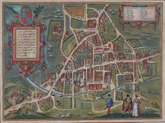
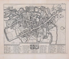
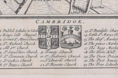
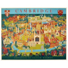
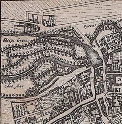
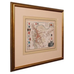
contemporary creations for a more modern example of these cherished works. If you’re looking for a cambridge map from a specific time period, our collection is diverse and broad-ranging, and you’ll find at least one that dates back to the 18th Century while another version may have been produced as recently as the 21st Century. If you’re looking to add a cambridge map to create new energy in an otherwise neutral space in your home, you can find a work on 1stDibs that features elements of gray, beige, brown, black and more. There have been many interesting cambridge map examples over the years, but those made by
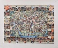
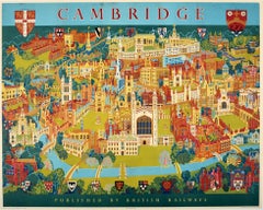
 Pieter Van Der Aa, Donise English, Suzanne Benton, Cris Gianakos and Leslie MacDonald Gill are often thought to be among the most thought-provoking. These artworks were handmade with extraordinary care, with artists most often working in engraving, paint and paper.

How Much is a Cambridge Map?

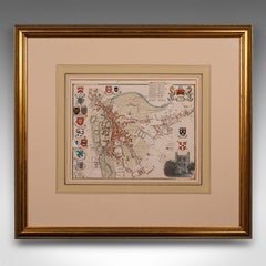
A cambridge map can differ in price owing to various characteristics — the average selling price for items in our inventory is $741, while the lowest priced sells for $125 and the highest can go for as much as $45,494.