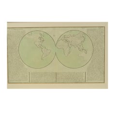
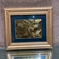
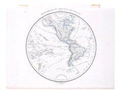
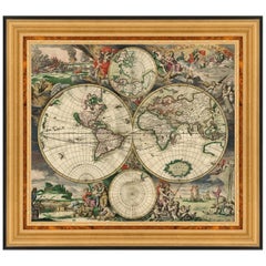
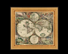
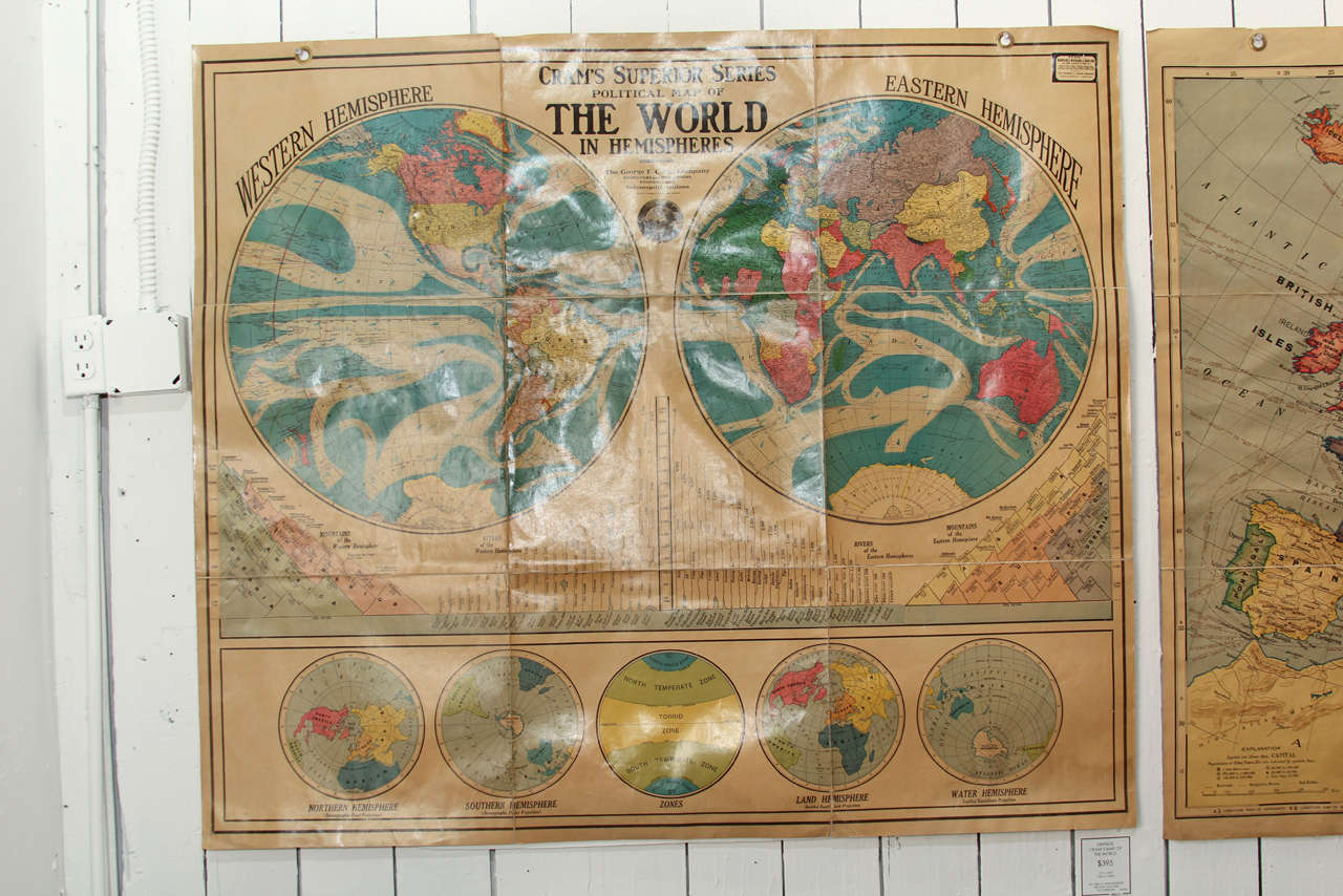
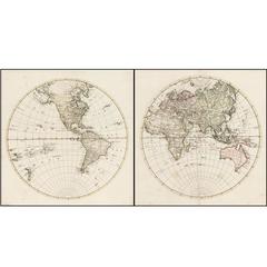
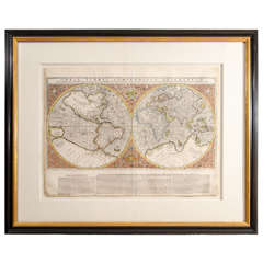
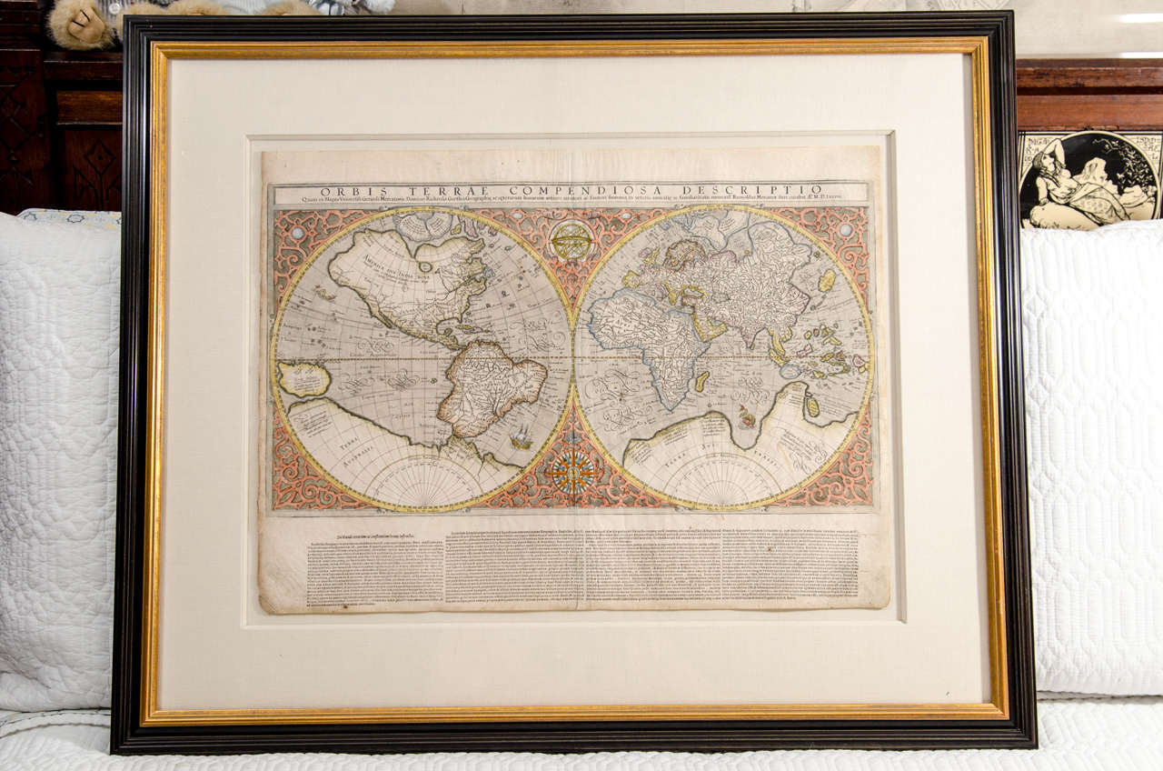
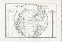
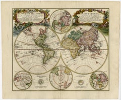
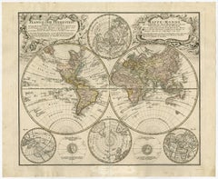
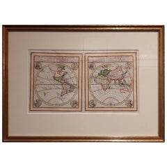
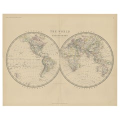
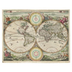
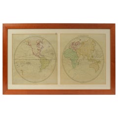
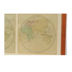
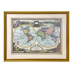
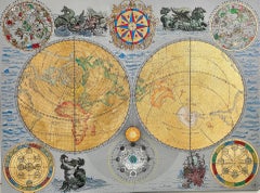
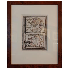
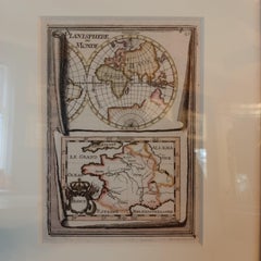
Hemispheres Map

to
40
102
46
73
56
52
24
23
23
14
13
12
12
9
7
6
6
6
5
5
5
4
4
3
3
3
2
2
2
2
1
1
1
1
1
1
1
1
1
1
1
1
3
2
2
1
1
Sort By
1850 Old French Map Depicting the Entire Earth's Surface Divided into Two Parts

1850 Old French Map Depicting the Entire Earth's Surface Divided into Two Parts

Located in Milan, IT

Geographical map depicting the entire earth's surface divided into two parts that correspond to the two hemispheres or globes, the map deals with the earth in general.

Category

Antique Mid-19th Century French Maps

Materials

Glass, Wood, Paper

1850 Old French Map Depicting the Entire Earth's Surface Divided into Two Parts

1850 Old French Map Depicting the Entire Earth's Surface Divided into Two Parts

Located in Milan, IT

Geographical map depicting the entire earth’s surface divided into two parts that correspond to the two hemispheres or globes, the map deals with the latitudes and longitudes, the me...

Category

Antique Mid-19th Century French Maps

Materials

Glass, Wood, Paper

Late 20th Century Gold Foil World Map Double Hemisphere

Late 20th Century Gold Foil World Map Double Hemisphere

Located in Chula Vista, CA

Late 20th Century Gold Foil Ancient World Map Double Hemisphere Gold Foil Old World Framed Map information on reverse of the print.

Category

Late 20th Century English Mid-Century Modern Prints

Materials

Gold

Hemisphere Of The New Continent - Ancient Map by J.G. Heck - 1834.

Hemisphere Of The New Continent - Ancient Map by J.G. Heck - 1834.

By Johann Georg Heck

Located in Roma, IT

Hemisphere Of The New Continent - West is an artwork realized in 1834 by Johann Georg Heck Original colored print. Good conditions except for yellowing of the paper and very littl...

Category

1830s Modern Figurative Prints

Materials

Etching

Hemisphere Of The New Continent - Ancient Map by J.G. Heck - 1834.

Hemisphere Of The New Continent - Ancient Map by J.G. Heck - 1834.

By Johann Georg Heck

Located in Roma, IT

Hemisphere Of The New Continent is an artwork realized around 1760 by Johann Georg Heck Original colored print. Good conditions except for yellowing of paper and tears along the m...

Category

1830s Modern Figurative Prints

Materials

Etching

Antique Print of Celestial Hemispheres, 1854

Antique Print of Celestial Hemispheres, 1854

Located in Langweer, NL

Antique world map titled 'Northern Celestial Hemisphere - Southern Celestial Hemisphere'.

Category

Antique 19th Century English Prints

Materials

Paper

Tout l'Univers N° 174 — Février 1965 — Égypte Ancienne, Révolution - 2C146

Tout l'Univers N° 174 — Février 1965 — Égypte Ancienne, Révolution - 2C146

Located in Bordeaux, FR

The Egyptian cover painting — dramatic, academically rendered, immediately frameable — is among the most visually striking covers in the magazine's history; ancient Egypt covers are ...

Category

20th Century Toys and Dolls

Materials

Paper

WORLD MAP - Planisphaerium Terrestre Sive Terrarum Orbis... 1696

WORLD MAP - Planisphaerium Terrestre Sive Terrarum Orbis... 1696

By Carel Allard

Located in Santa Monica, CA

CAREL ALLARD (1648 – 1709) PLANISPHAERIUM TERRESTRE SIVE TERRARUM ORBIS… 1696 (Shirley 578) Engraving, 20 ½ x 23 ½”, sheet 21 x 24 1/8". A stunning double hemisphere World Map wi...

Category

17th Century Old Masters Landscape Prints

Materials

Engraving

Map of Kerguelen’s Land: The Island of Desolation Explored by Captain Cook

Map of Kerguelen’s Land: The Island of Desolation Explored by Captain Cook

Located in Langweer, NL

Cook’s subsequent exploration and observations contributed to refining the map of this remote island, and his experience here was part of the broader narrative of his voyages to expl...

Category

Antique 1780s Prints

Materials

Paper

4 Vintage Culver, Terrarum Orbis Geographica Double Rocks Glasses

4 Vintage Culver, Terrarum Orbis Geographica Double Rocks Glasses

By Culver Ltd.

Located in Nantucket, MA

Vintage set of 4 Culver, LTD. large rocks glasses with open fields on a simulated leather background, the open fields decorated with old world maps of the eastern and western hemisph...

Category

Vintage 1970s American Mid-Century Modern Barware

Materials

Glass

New Hemispherical Map of the World, After Baroque Engraving

New Hemispherical Map of the World, After Baroque Engraving

Located in Fairhope, AL

This large, Fine Art Masterpiece is a faithful yet nuanced replica of the "New Hemispherical Map of the World" while the original Rococo Engraving was rendered in 1689 by Dutch carto...

Category

21st Century and Contemporary Dutch Rococo Decorative Art

Western Hemisphere Map with California as an Island

Western Hemisphere Map with California as an Island

Located in New York, NY

Circa 1675 to 1700 beautifully hand-colored engraved map of the Western Hemisphere including typical cartographical errors common at that time.

Category

Late 17th Century Realist Landscape Prints

Materials

Engraving

Western Hemisphere Map with California as an Island

Western Hemisphere Map with California as an Island

Located in New York, NY

Circa 1675 to 1700 beautifully hand-colored engraved map of the Western Hemisphere including typical cartographical errors common at that time.

Category

Late 17th Century Realist Landscape Prints

Materials

Engraving

1701 Western Hemisphere Map with California as an Island

1701 Western Hemisphere Map with California as an Island

Located in New York, NY

This map is based upon earlier 17th Century renderings of the Western Hemisphere.

Category

Early 1700s Realist Landscape Prints

Materials

Engraving

Extremely Rare Mappemonde a l'usage World Map Delisle, Guillaume Buache, 1730

Extremely Rare Mappemonde a l'usage World Map Delisle, Guillaume Buache, 1730

Located in Drottningholm, SE

Engraved large double-hemisphere map with outline colour, title above the map with the large French coat-of-arms in the middle, surrounded by allegorical figures of the four continen...

Category

Antique 1730s Dutch Maps

Materials

Paper

Political Map Of The World In Hemispheres

Political Map Of The World In Hemispheres

By George F. Cram

Located in Seattle, WA

Artistic as it is educational this stunning vintage Cram's Superior Series Map of the World will light up any environment.

Category

Vintage 1940s American Industrial Maps

Materials

Linen

Rare 1790s Russian Map of the World

Rare 1790s Russian Map of the World

Located in La Jolla, CA

Rare set of Eastern Hemisphere and Western Hemisphere maps, with place names in Cyrillic, likely published at the end of the 18th century.

Category

Antique 1790s Russian Prints

Materials

Paper

Mercator's Double Hemisphere World Map

Mercator's Double Hemisphere World Map

By Gerard Mercator

Located in New York, NY

Gerard (1512 - 1594) and Rumold (1545 - 1599) Mercator Orbis Terrae Compendiosa Descriptio. . . Engraving with original hand-color from Strabonis Rerum Geographicarum 15 1/2 x 2...

Category

Antique 18th Century and Earlier Prints

Large Scale Double-Hemisphere World Map; Wall Map

Large Scale Double-Hemisphere World Map; Wall Map

By Herman Moll

Located in New York, NY

Herman Moll A New and Correct Map of the World... Published, London c. 1709 Engraving with original hand-coloring. Ptinted for H. Moll, D. Midwinter and T. Bowles, Printsellers...

Category

Antique 18th Century and Earlier British Prints

Map of the Southwestern Hemisphere by Bonne - Engraving - 18th Century

Map of the Southwestern Hemisphere by Bonne - Engraving - 18th Century

Located in Zeeland, Noord-Brabant

Subject: Antique print, titled: 'Mappe Monde sur un Plan Horisontal, situe a 45d de latitude Sud Hemisphere Occidental.' - Detailed map of the Southwestern Hemisphere, highlighting a...

Category

1780s Contemporary More Prints

Materials

Engraving

Map of the Northern Hemisphere by Bonne - Engraving - 18th Century

Map of the Northern Hemisphere by Bonne - Engraving - 18th Century

Located in Zeeland, Noord-Brabant

Subject: Antique print, titled: 'Mappe Monde, sur le Plan de l'Equateur. Hemisphere Septentrional.' - Map of the Northern Hemisphere.

Category

1780s Contemporary More Prints

Materials

Engraving

Map of the Eastern Hemisphere by Bonne - Engraving - 18th Century

Map of the Eastern Hemisphere by Bonne - Engraving - 18th Century

Located in Zeeland, Noord-Brabant

Subject: Antique print, titled: 'Mappe-Monde sur Le Plan D'Un Meridien Hemisphere Orientale (…).' - Handsome map of the Eastern Hemisphere, illustrating the cartographic updates prov...

Category

1780s Contemporary More Prints

Materials

Engraving

Map of the Western Hemisphere by Bonne - Engraving - 18th Century

Map of the Western Hemisphere by Bonne - Engraving - 18th Century

Located in Zeeland, Noord-Brabant

Subject: Antique print, titled: 'Mappe-Monde sur Le Plan D'Un Meridien Hemisphere Occidentale.' - Detailed map of the Western Hemisphere, illustrating the cartographic updates provid...

Category

1780s Contemporary More Prints

Materials

Engraving

Map of the Northeastern Hemisphere by Bonne - Engraving - 18th Century

Map of the Northeastern Hemisphere by Bonne - Engraving - 18th Century

Located in Zeeland, Noord-Brabant

Subject: Antique print, titled: 'Mappe Monde, sur un Plan Horisontal, situe a 45d de latitude Nord Hemisphere Oriental.' - Detailed map showing the Northeastern Hemisphere, including...

Category

1780s Contemporary More Prints

Materials

Engraving

Map of the Southern Hemisphere by Bonne - Engraving - 18th Century

Map of the Southern Hemisphere by Bonne - Engraving - 18th Century

Located in Zeeland, Noord-Brabant

Subject: Antique print, titled: 'Mappe Monde, sur le Plan de l'Equateur. Hemisphere Meridional.' - Map of the Southern Hemisphere centered on the South Pole, from the South Pole up t...

Category

1780s Contemporary More Prints

Materials

Engraving

1800s French Map of the World in Two Hemispheres - Le Dictionnaire Géographique

1800s French Map of the World in Two Hemispheres - Le Dictionnaire Géographique

Located in Montréal, CA

Mappe-Monde. En deux Hemispheres Pour le Dictionnaire Géographique. Author: Vosgien and Caillot Source / Publication: Le Dictionnaire Géographique, ou Description de toutes les Parti...

Category

Antique Early 19th Century French Prints

Materials

Paper

Original Vintage Travel Poster BOAC World Air Routes Western Hemisphere Design

Original Vintage Travel Poster BOAC World Air Routes Western Hemisphere Design

Located in London, GB

Original vintage travel advertising poster for BOAC World Air Routes Western Hemisphere featuring a pictorial map with colourful illustrations of people in national dress, places of ...

Category

1940s More Prints

Materials

Paper

Mappe-Monde Ou Carte Generale De La Terre Divisee En Deux Hemispheres

Mappe-Monde Ou Carte Generale De La Terre Divisee En Deux Hemispheres

By Louis Charles Desnos

Located in La Jolla, CA

A remarkable wall map of the world by Densos, in an unrecorded variant state, with an unusual depiction of Australia and equally fascinating joinder of New Zealand to Terra Australis...

Category

Antique 1770s French Baroque Prints

Materials

Paper

Highly Decorative Italian Wall Map of the World

Highly Decorative Italian Wall Map of the World

By Paolo Petrini

Located in La Jolla, CA

This large-scale double-hemisphere world map represents the high point of geographic printing in Naples at the end of the 17th century.

Category

Antique Early 1700s Italian Baroque Prints

Materials

Paper

Antique world map - Mappe Monde by Lowitz - Handcoloured engraving - 18th c.

Antique world map - Mappe Monde by Lowitz - Handcoloured engraving - 18th c.

Located in Zeeland, Noord-Brabant

Mappe-Monde.' - Double hemisphere world map. Several small insep maps show the North and South poles, also in Nuremberg projection.

Category

1740s Old Masters More Prints

Materials

Engraving

Mappe Monde.

Mappe Monde.

By Valentine Francoise Dumont

Located in Zeeland, Noord-Brabant

Pen and ink drawing, handcoloured, on vellin paper. Manuscript double hemisphere world map, with the continents colored in outline.

Category

1860s Landscape Drawings and Watercolors

Materials

Ink, Pen

Planiglobii Terrestris.

Planiglobii Terrestris.

By Johann Baptist Homann

Located in Zeeland, Noord-Brabant

Original handcoloured etching/engraving on laid paper. Double hemisphere world map. Several small inset maps show the North and South poles in Nuremberg projection.

Category

1740s More Prints

Materials

Engraving, Etching

Mid-18th Century Eight Day Oak Longcase Clock by John Taylor of Manchester

Mid-18th Century Eight Day Oak Longcase Clock by John Taylor of Manchester

Located in Worcester, Worcestershire

Interesting rolling moon to the lunette with two brass hemisphere terrestial maps. Two winding holes, blued steel clock hands.

Category

Antique 18th Century Scientific Instruments

Materials

Mahogany

Antique World Map by Lapie, 1842

Antique World Map by Lapie, 1842

Located in Langweer, NL

Antique map titled 'Mappe-Monde en deux Hemispheres'. Map of the world.

Category

Antique Mid-19th Century Maps

Materials

Paper

Antique World Map Published in Vienna 1786 by Franz Anton Schraembl

Antique World Map Published in Vienna 1786 by Franz Anton Schraembl

Located in Milan, IT

It is a geographical map printed by engraving on a copper plate, light coloring Coeval at the borders, which depicts the entire earth's surface divided into two parts that correspond...

Category

Antique 1780s Austrian Maps

Materials

Glass, Wood, Paper

Decorative Antique World Map with two Hemispheres

Decorative Antique World Map with two Hemispheres

Located in Langweer, NL

Very decorative world map with two hemispheres. These are surrounded by several globes.

Category

Antique Mid-18th Century Maps

Materials

Paper

Antique Map of the Eastern and Western Hemisphere by Bodenehr, circa 1720

Antique Map of the Eastern and Western Hemisphere by Bodenehr, circa 1720

Located in Langweer, NL

Two maps on one sheet depicting the eastern and western hemispheres and the continents of North America, South America, Africa, Europe and Asia.

Category

Antique Early 18th Century Maps

Materials

Paper

TAI Original Airline Travel Map 1950’s, Bayle

TAI Original Airline Travel Map 1950’s, Bayle

Located in Bath, Somerset

Transport Aeriens Intercontinentaux decorative double hemisphere map by Luc Marie Bayle. The hemispheres are surrounded by images of explorers in various forms of transport including...

Category

20th Century French Posters

Materials

Linen, Paper

Antique Hand Colored Hemispheres by John Thomson

Antique Hand Colored Hemispheres by John Thomson

By John Thomson

Located in Astoria, NY

A pair of hand colored and engraved world maps depicting the eastern and western hemispheres.

Category

Antique 19th Century British Maps

Materials

Paper

Antique World Map by Johnston, 1882

Antique World Map by Johnston, 1882

Located in Langweer, NL

Antique map titled 'The World in Hemispheres'. Old double-hemisphere world map.

Category

Antique 19th Century Maps

Materials

Paper

Antique Map of the World by Stoopendaal, c.1714

Antique Map of the World by Stoopendaal, c.1714

Located in Langweer, NL

Decorative double hemisphere world map. Illustrated with numerous exotic animals and four female allegorical representations of the continents.

Category

Antique 18th Century Maps

Materials

Paper

World Map Published in June 1783 by Stackhouse and Engraved by S.J. Neele London

World Map Published in June 1783 by Stackhouse and Engraved by S.J. Neele London

Located in Milan, IT

Neele. It is a geographical map printed by engraving on a copper plate, coeval coloring, which depicts the entire earth's surface divided into two parts that correspond to the two he...

Category

Antique 1780s British Maps

Materials

Glass, Wood, Paper

Typus Orbis Terrarum, Antique Map 1667

Typus Orbis Terrarum, Antique Map 1667

By Matthäus Merian the Younger

Located in Soquel, CA

Hand-colored twin hemisphere map of the world by Matthaus Merian. From Gottfried's "Historische Cronica (1657) or Gorhm's "Vermehrte Archotologica Cosmica (1695).

Category

17th Century Landscape Prints

Materials

Printer's Ink, Watercolor, Rag Paper

Late 20th Century Educational Geographic Map - Hemispheres

Late 20th Century Educational Geographic Map - Hemispheres

Located in Hook, Hampshire

Late 20th Century Educational Geographic Map – Hemispheres Late 20th Century Educational Geographic Map – Hemispheres.

Category

Late 20th Century Czech Posters

Materials

Cotton

Double Hemisphere Old World Map Print,  Matted & Framed

Double Hemisphere Old World Map Print, Matted & Framed

Located in Plainview, NY

A double hemisphere old world map print. The map is a reproduction of the original of the 1788 Mapa Mondo made in Rome Italy.

Category

20th Century Landscape Prints

Materials

Paper

Terra Mare - historical map cartography hemispheres marine mixed media painting

Terra Mare - historical map cartography hemispheres marine mixed media painting

By Marco Araldi

Located in London, GB

Marco’s background is in engineering and architecture, making him familiar with mathematical design and the awareness of geometry. When he decided to create art, he was naturally dra...

Category

2010s Contemporary Landscape Paintings

Materials

Gold Leaf

Maps for the Southern Hemisphere. Antique Astronomy star constellation print

Maps for the Southern Hemisphere. Antique Astronomy star constellation print

By William Peck

Located in Melbourne, Victoria

Colour lithograph, 1890. 285mm by 210mm (sheet). From W Peck's 'A Handbook and Atlas of Astronomy', 1890. Sir William Peck FRSE FRAS (1862 – 1925) was a Scottish astronomer and scien...

Category

Late 19th Century Victorian More Prints

Materials

Lithograph

Maps for the Northern Hemisphere. Antique Astronomy star constellation print

Maps for the Northern Hemisphere. Antique Astronomy star constellation print

By William Peck

Located in Melbourne, Victoria

Colour lithograph, 1890. 285mm by 210mm (sheet). From W Peck's 'A Handbook and Atlas of Astronomy', 1890. Sir William Peck FRSE FRAS (1862 – 1925) was a Scottish astronomer and scien...

Category

Late 19th Century Victorian More Prints

Materials

Lithograph

Vacheron Constantin Mercator Watch

Vacheron Constantin Mercator Watch

By Vacheron Constantin

Located in New Orleans, LA

The 16th-century cartographer is renowned for creating the first flat maps of the globe for navigators. Thus, the watch's dial is enameled with Mercator’s navigational hemisphere maps.

Category

20th Century Swiss Modern Wrist Watches

Materials

18k Gold, White Gold

  • 1
Get Updated with New Arrivals
Save "Hemispheres Map", and we’ll notify you when there are new listings in this category.

Hemispheres Map For Sale on 1stDibs

With a vast inventory of beautiful furniture at 1stDibs, we’ve got just the hemispheres map you’re looking for. Frequently made of paper, canvas and fabric, every hemispheres map was constructed with great care. You’ve searched high and low for the perfect hemispheres map — we have versions that date back to the 18th Century alongside those produced as recently as the 20th Century are available. Each hemispheres map bearing hallmarks is very popular. You’ll likely find more than one hemispheres map that is appealing in its simplicity, but Antonio Zatta, Guillaume De L'Isle and John Thomson produced versions that are worth a look.

How Much is a Hemispheres Map?

A hemispheres map can differ in price owing to various characteristics — the average selling price 1stDibs is $618, while the lowest priced sells for $185 and the highest can go for as much as $5,562.