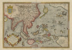
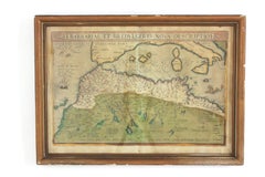
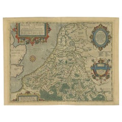
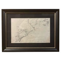
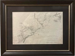
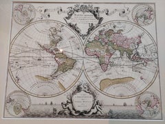
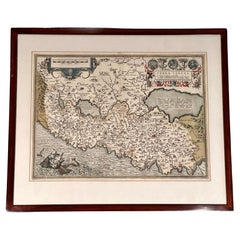
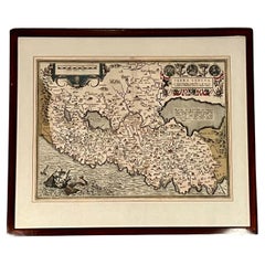
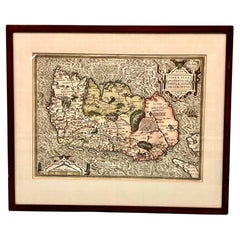
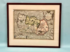
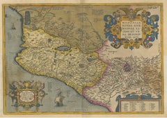
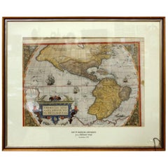
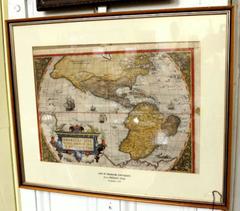
Abraham Ortelius Furniture

Dutch, 1527-1598

Abraham Ortelius is widely recognized as the inventor of the atlas and one of the most prominent geographers in history. He is one of the best known and most frequently collected of all sixteenth-century mapmakers, and today, hand-colored, copperplate-printed Abraham Ortelius maps continue to command avid interest.

Ortelius was the eldest of the three children of an Antwerp merchant. After his father's death when he was ten, he was raised by his uncle Jacob Van Meteren — a financier and printer of early English versions of the Bible. Ortelius entered the Guild of Saint Luke in 1547 to become a map copier and colorist, but his hobbies overshadowed his studies. 

Ortelius was better known as a student of history and a collector of books and old coins than a cartographer — only initially garnering modest praise for his skills at mapmaking. Gleaning what he learned from his uncle, he became a dealer in books and prints. In 1554 he attended the annual Frankfurt Book Fair, where he met the highly respected cartographer Gerardus Mercator.

Ortelius refocused his work in mapmaking after that fateful encounter. He eventually published Theatrum Orbis Terrarum (Theater of the World) — a comprehensive collection of maps that he bound into a book. It was the first of its kind and is now recognized as the first modern-day atlas. While creating his atlas, Ortelius observed that the coast of America shared geometrical similarities with the shores of Europe and Africa. When he lined up maps of the coastlines of the continents, they matched — much like pieces in a jigsaw puzzle. 

Some have argued that the concept of continental drift is at least partly rooted in Ortelius’s 16th-century-era suggestion that the continents had once been joined together as a single mass of land before the Americas were pulled away from Europe and Africa. Much later, in 1912, German meteorologist Alfred Wegener proposed in a lecture and an article that the continents had once been locked together based on data he collected. Wegener was widely ridiculed at the time, but the foundation of modern-day science of plate tectonics has its origins in his work.

On May 18, 2008, a Google Doodle celebrated the 300th anniversary of Ortelius’s atlas.

On 1stDibs, find original Abraham Ortelius prints, landscape prints and more.

to
4
6
6
5
1
6
1
1
3
2
6
6
6
7
11,368
3,911
2,408
2,232
Creator: Abraham Ortelius
Hand Colored Framed Map Print of North Africa
By Abraham Ortelius
Located in Barcelona, ES
Original antique map of North Africa Antique framed map print titled 'Barbariae et Biledulgerid Nova Descriptio'. Artist: Abraham Ortelius (1527 -1598) Published by A. Ortelius, ci...
Category

20th Century European Spanish Colonial Abraham Ortelius Furniture

Materials

Giltwood, Paper

Antique Map of Southeast Asia by Ortelius '1587'
By Abraham Ortelius
Located in Langweer, NL
Antique map titled 'Indiae Orientalis Insularumque Adiacientium Typus'. Ortelius includes early European depictions of both Japan and China and is the first to name Formosa (Taiwan). The Philippines and East Indies or Spice Islands are shown based upon Portuguese and Spanish sources, and before their penetration by the Dutch. Japan is shown in kite form, as a large oval island...
Category

16th Century Antique Abraham Ortelius Furniture

Materials

Paper

Antique Miniature Map of the Roman Province of Illyricum 'Dalmatia', 1612
By Abraham Ortelius
Located in Langweer, NL
Antique miniature map titled 'Illyricum'. Original small map of Illyricum. The Roman province of Illyricum stretched from the Drilon River (the Drin, in...
Category

Early 17th Century Belgian Antique Abraham Ortelius Furniture

Materials

Paper

Coloured Antique Map of Sicily, Sardinia, Corfu, Elba, Malta and Zerbi (Jerba)
By Abraham Ortelius
Located in Langweer, NL
Antique map titled 'Insularum Aliquot Maris Mediterranei Descriptio'. A very attractive example of Ortelius' map combining, on one page, maps of the islands of Sicily, Sardinia, Corfu, Elba, Malta and Zerbi (Jerba, off the coast of Tunisia.) The maps detail fortifications on the islands and other major features. (Jerba, for instance, is shown connected to the mainland by a causeway.) The waters are attractively engraved and are sailed by ships. A shipwreck, north of Malta, indicates the point at which St. Paul is thought to have shipwrecked. Volcanoes are indicated in the Sicily map...
Category

16th Century Belgian Antique Abraham Ortelius Furniture

Materials

Paper

Antique Map of the Region of Mansfeld, Saxony-Anhalt, Germany
By Abraham Ortelius
Located in Langweer, NL
Antique map titled 'Mansfeldiae Comitatus Descriptio'. Original antique map of the region of Mansfeld, Saxony-Anhalt, Germany. Shows the area between Halle a. d. Saale, Aschersleben,...
Category

Early 17th Century Antique Abraham Ortelius Furniture

Materials

Paper

Antique Map of the Low Countries by Ortelius, 1584
By Abraham Ortelius
Located in Langweer, NL
Antique map titled 'Belgii Veteris Typus'. Beautiful map of the Low Countries, extending to the English Channel and part of Britain. This map originates from Ortelius' 'Theatrum Orbi...
Category

16th Century Antique Abraham Ortelius Furniture

Materials

Paper

Related Items
Antique Map of Principality of Monaco
By Antonio Vallardi Editore
Located in Alessandria, Piemonte
ST/619 - "Old Geographical Atlas of Italy - Topographic map of ex-Principality of Monaco" - ediz Vallardi - Milano - A somewhat special edition ---  
Category

Late 19th Century Italian Other Antique Abraham Ortelius Furniture

Materials

Paper

Antique Map of Principality of Monaco
$450
H 22.84 in W 15.75 in D 0.04 in
New Map of North America from the Latest Discoveries, 1763
Located in Philadelphia, PA
A fine antique 18th century map of the North American seaboard. Entitled "A New Map of North America from the Latest Discoveries 1763". By the Cartographer/Engraver - John Spil...
Category

Mid-18th Century English Georgian Antique Abraham Ortelius Furniture

Materials

Paper

Original Antique Map of The London Underground. 1911
Located in St Annes, Lancashire
Superb map of The London Underground Published by Ward Lock, 1911 Folding map. Printed on paper Unframed. Good condition/ Minor repair to an edge tear on right edge ( shown in ...
Category

1910s English Vintage Abraham Ortelius Furniture

Materials

Canvas, Paper

Original Antique Map of Ancient Greece, Achaia, Corinth, 1786
Located in St Annes, Lancashire
Great map of Ancient Greece. Showing the region of Thessaly, including Mount Olympus Drawn by J.D. Barbie Du Bocage Copper plate engraving by P.F Tardieu Original hand color...
Category

1780s French Other Antique Abraham Ortelius Furniture

Materials

Paper

Original Antique Map of The World by Dower, circa 1835
Located in St Annes, Lancashire
Nice map of the World Drawn and engraved by J.Dower Published by Orr & Smith. C.1835 Unframed. Free shipping
Category

1830s English Antique Abraham Ortelius Furniture

Materials

Paper

Original Antique Hand- Map of Africa by Allard '1697'
Located in Langweer, NL
Antique map titled 'Novissima et Perfectissima Africae (..)'. Beautiful large map of Africa. This is the 3rd state of the map, with climate notation add...
Category

Late 17th Century Antique Abraham Ortelius Furniture

Materials

Paper

Original Antique Hand- Map of Africa by Allard '1697'
$1,156 Sale Price
35% Off
H 21.66 in W 25.2 in D 0.02 in
Vintage "View of the Center of Paris Taken from the Air" Lithograph Map
Located in San Diego, CA
A very stylish "View of the Center of Paris Taken from the Air" lithograph map published by the Paris Ministry of Tourism, circa early 1950s. The piece measures 27" x 43" and shows...
Category

20th Century French Mid-Century Modern Abraham Ortelius Furniture

Materials

Paper

1592 Abraham Ortelius Map "Lorraine: Lotharingiae Nova Descripti, Ric.A005
Located in Norton, MA
1592 Abraham Ortelius map entitled "Lorraine: Lotharingiae Nova Descripti Ric.a005 Description: Ortelius is best known for producing the atlas from which this map comes from, "...
Category

16th Century Dutch Antique Abraham Ortelius Furniture

Materials

Paper

Antique 18th Century Map of the Province of Pensilvania 'Pennsylvania State'
Located in Philadelphia, PA
A fine antique of the colony of Pennsylvania. Noted at the top of the sheet as a 'Map of the province of Pensilvania'. This undated and anonymous map is thought to be from the Gentleman's Magazine, London, circa 1775, although the general appearance could date it to the 1760's. The southern boundary reflects the Mason-Dixon survey (1768), the western boundary is placed just west of Pittsburgh, and the northern boundary is not marked. The map has a number of reference points that likely refer to companion text and appear to be connected to boundaries. The western and southern boundaries are marked Q, R, S, for example. A diagonal line runs from the Susquehanna R to the Lake Erie P. A broken line marked by many letters A, B, N, O, etc., appears in the east. There are no latitude or longitude markings, blank verso. Framed in a shaped contemporary gilt wooden frame and matted under a cream colored matte. Bearing an old Graham Arader Gallery...
Category

18th Century British American Colonial Antique Abraham Ortelius Furniture

Materials

Paper

Original Antique Hand-colored World Map with or without Frame, '1696'
Located in Langweer, NL
Antique world map titled 'Mappe-Monde dressee sur les Observations de Mrs. de l'Academie Royale des Sciences (..)'. Beautiful original antique world map...
Category

Late 17th Century French Antique Abraham Ortelius Furniture

Materials

Paper

Original Hand-Colored Antique Map of Africa by Elwe '1792'
Located in Langweer, NL
Antique map titled 'l'Afrique Divisée en ses Empires, Royaumes, et Etats'. Decorative large map of Africa. The cartography is typical for the 17th century with the Nile originating i...
Category

Late 18th Century Antique Abraham Ortelius Furniture

Materials

Paper

Original Hand-Colored Antique Map of Africa by Elwe '1792'
$948 Sale Price
20% Off
H 21.66 in W 26.78 in D 0.02 in
Gold Leaf Foil Pictorial Plan Map of the West Country of England Antique Style
Located in West Sussex, Pulborough
We are delighted to offer for sale this lovely Antique style pictorial plan map of the West Country of England etched in gold leaf foil This is a very interesting and decorative p...
Category

20th Century English Adam Style Abraham Ortelius Furniture

Materials

Gold Leaf

Previously Available Items
"Terra Sancta" Map of the Holy Land by Abraham Ortelius (1527-1598) Framed
By Abraham Ortelius
Located in San Francisco, CA
Abraham Ortelius (1527-1598) was a cartographer, geographer and map maker from Antwerp in the Spanish Netherlands. He created the first modern atlas, titled in Latin "Theatrum Orbis ...
Category

17th Century Belgian Baroque Antique Abraham Ortelius Furniture

Materials

Paper

Map of Ireland Titled "Hiberniae Britannicae Insulae Nova Descriptio Irland"
By Abraham Ortelius
Located in San Francisco, CA
Abraham Ortelius (1527-1598) was a cartographer, geographer and maker from Antwerp in the Spanish Netherlands. He created the first modern atlas titled in Latin Theatrum Orbis Terrar...
Category

Early 18th Century Belgian Antique Abraham Ortelius Furniture

Materials

Paper

Abraham Ortelius Map of Greece Hand Colored Engraving Circa 1579
By Abraham Ortelius
Located in Atlanta, GA
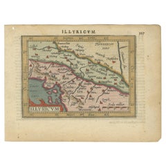
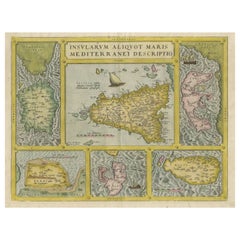
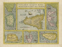
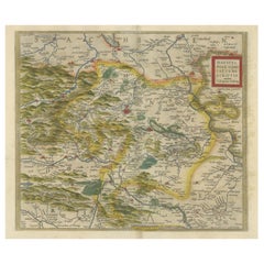
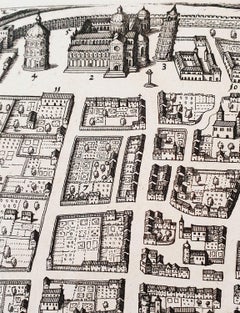
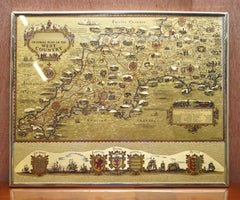
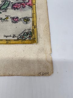
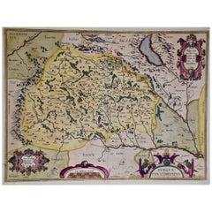
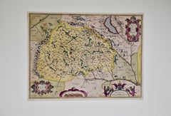
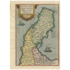
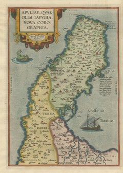
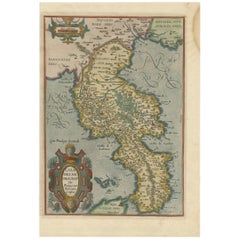
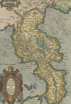
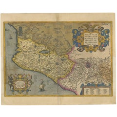
Copper engraving, printing on paper. Verso text is Latin, original hand coloring. From: From: Theatrum Orbis Terrarum, Antwerpen, Gillis van den Rade, 1575. Abraham Ortelius (1527-1598) The maker of the 'first atlas', the Theatrum Orbis Terrarum (1570), was born on 4 April 1527 into an old Antwerp family. He learned Latin and studied Greek and mathematics. Abraham and his sisters Anne and Elizabeth took up map colouring. He was admitted to the Guild of St. Luke as an "illuminator of maps." Besides colouring maps, Ortelius was a dealer in antiques, coins, maps, and books, with the book and map trade gradually becoming his primary occupation. Business went well because his means permitted him to start an extensive collection of medals, coins, antiques, and a library of many volumes. In addition, he travelled a lot and visited Italy and France, made contacts everywhere with scholars and editors, and maintained extensive correspondence with them. In 1564 he published his first map, a large and ambitious world wall map. The inspiration for this map may well have been Gastaldi's large world map. In 1565 he published a map of Egypt and a map of the Holy Land, a large map of Asia followed. In 1568 the production of individual maps for his atlas Theatrum Orbis Terrarum was already in full swing. He completed the atlas in 1569, and in May of 1570, the Theatrum was available for sale. It was one of the most expensive books ever published. This first edition contained seventy maps on fifty-three sheets. Franciscus Hogenberg engraved the maps. Later editions included Additamenta (additions), resulting in Ortelius' historical atlas, the Parergon, mostly bound together with the atlas. The Parergon can be called a truly original work of Ortelius, who drew the maps based on his research. The importance of the Theatrum Orbis Terrarum for geographical knowledge in the last quarter of the sixteenth century is difficult to overemphasize. Nothing was like it until Mercator's atlas appeared twenty-five years later. Demand for the Theatrum was remarkable. Some 24 editions appeared during Ortelius's lifetime and another ten after his death in 1598. Editions were published in Dutch, German, French, Spanish, English, and Italian. The number of map sheets grew from 53 in 1570 to 167 in 1612 in the last edition. In 1577, engraver Philip Galle...
Category

16th Century British Antique Abraham Ortelius Furniture

Materials

Paper

Antique Map of the Region of Apulia by Ortelius, 1612
By Abraham Ortelius
Located in Langweer, NL
Antique map titled 'Apuliae, quae olim Lapygia nova corographia'. Beautiful map of the region of Apulia, Italy. This map originates from 'Theatrum Orbis Terrarum' by A. Ortelius.
Category

Early 17th Century Antique Abraham Ortelius Furniture

Materials

Paper

Antique Map of the Region of Calabria by Ortelius, 1612
By Abraham Ortelius
Located in Langweer, NL
Antique map titled 'Calabriae Descrip. Per Prosperum Parisium Consent'. Beautiful map of the region of Calabria, Southern Italy. This map originates from 'Theatrum Orbis Terrarum' by...
Category

Early 17th Century Antique Abraham Ortelius Furniture

Materials

Paper

Antique Map of Mexico by Ortelius, circa 1602
By Abraham Ortelius
Located in Langweer, NL
Antique map titled 'Hispaniae Novae Sivae Magnae Recens Et Vera Descriptio 1579'. Map of western New Spain, showing the recently-created Spanish settlements, many rivers, and large l...
Category

Early 17th Century Belgian Antique Abraham Ortelius Furniture

Materials

Paper

Antique Map of Mexico by Ortelius, circa 1602
H 16.93 in W 20.87 in D 0.02 in
Map of the Americas by Abraham Ortelius, 16th Century Framed Original Engraving
By Abraham Ortelius
Located in CHARLESTON, SC
Rare and fine framed engraving map of the Americas "Americae Sive Novi Orbin Nova Descriptio" by Abraham Ortelius (hand colored later) Ortelius' map of the Americas is the most re...
Category

16th Century American Antique Abraham Ortelius Furniture

Materials

Paper

Abraham Ortelius furniture for sale on 1stDibs.

Abraham Ortelius furniture are available for sale on 1stDibs. These distinctive items are frequently made of paper and are designed with extraordinary care. There are many options to choose from in our collection of Abraham Ortelius furniture, although brown editions of this piece are particularly popular. If you’re looking for additional options, many customers also consider furniture by Philip Baldaeus, Covens & Mortier, and Arnoldus Montanus. Prices for Abraham Ortelius furniture can differ depending upon size, time period and other attributes — on 1stDibs, these items begin at $377 and can go as high as $3,784, while a piece like these, on average, fetch $724.

Recently Viewed

View All