
Frederick de Wit Prints

Dutch, 1630-1706
Frederick De Wit (1629-1706) was an engraver, cartographer and map dealer who ran a prominent and productive printing business in Amsterdam, founded in 1654 and initially called The Three Crabs and later The White Chart. He published his first atlas in 1662. In 1695 he purchased a large collection of the plates of the prestigious Blaeu publishing business. After his death in 1706, his wife Maria continued in the business for four years before selling it at the auction. A majority of the plates were purchased by Pieter Mortier. His thriving and growing business eventually became Covens & Mortier, one of the largest and most successful cartography and printing businesses of the eighteenth century.
to
1
1
1
2
Height
to
Width
to
2
2
1
1
2
2
2
33
107
104
93
80
Creator: Frederick de Wit
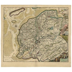
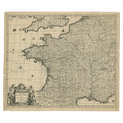
Large Antique Map of France by De Wit, c.1680
By Frederick de Wit
Located in Langweer, NL
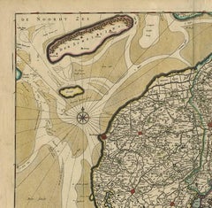
Antique map titled 'Accuratissima Galliae Tabula vulgo Royaume de France'. Detailed map of France. Shows provinces, cities, rivers etc. Artists and Engravers: Frederick de Wit (1...
Category

17th Century Antique Frederick de Wit Prints

Materials

Paper

Large 17th Century Hand Colored Map of England and the British Isles by de Wit
By Frederick de Wit
Located in Alamo, CA
A large hand colored 17th century map of England and the British Isles by Frederick de Wit entitled "Accuratissima Angliæ Regni et Walliæ Principatus", published in Amsterdam in 1680. It is a highly detailed map of England, Scotland, the Scottish Isles...
Category

Late 17th Century Dutch Antique Frederick de Wit Prints

Materials

Paper

Related Items
Antique Map of Principality of Monaco
By Antonio Vallardi Editore
Located in Alessandria, Piemonte
ST/619 - "Old Geographical Atlas of Italy - Topographic map of ex-Principality of Monaco" - ediz Vallardi - Milano - A somewhat special edition ---  
Category

Late 19th Century Italian Other Antique Frederick de Wit Prints

Materials

Paper

Antique Map of Principality of Monaco
H 22.84 in W 15.75 in D 0.04 in
Original Antique Map of Spain and Portugal, circa 1790
Located in St Annes, Lancashire
Super map of Spain and Portugal Copper plate engraving by A. Bell Published, circa 1790. Unframed.  
Category

1790s English Other Antique Frederick de Wit Prints

Materials

Paper

Original Antique Map of Ancient Greece, Achaia, Corinth, 1786
Located in St Annes, Lancashire
Great map of Ancient Greece. Showing the region of Thessaly, including Mount Olympus Drawn by J.D. Barbie Du Bocage Copper plate engraving by P.F Tardieu Original hand color...
Category

1780s French Other Antique Frederick de Wit Prints

Materials

Paper

Map of the Holy Land "Carte de la Syrie et de l'Egypte" by Pierre M. Lapie
By Pierre M. Lapie
Located in Alamo, CA
An early 19th century map of ancient Syria and Egypt entitled "Carte de la Syrie et de l'Egypte anciennes/dressée par M. Lapie, Colonel d'Etat Major, et...
Category

Early 19th Century French Antique Frederick de Wit Prints

Materials

Paper

Original Antique Map of South East Asia by Thomas Clerk, 1817
Located in St Annes, Lancashire
Great map of South East Asia Copper-plate engraving Drawn and engraved by Thomas Clerk, Edinburgh. Published by Mackenzie And Dent, 1817 Unframed.
Category

1810s English Antique Frederick de Wit Prints

Materials

Paper

"San Francisco, Upper California” 1851 Antique Map of San Francisco
Located in Colorado Springs, CO
This is a pictorial lettersheet view of the city and harbor of San Francisco. This lithograph was printed on grey wove paper, across a double sheet, by famed lithographers Britton & ...
Category

1850s American Antique Frederick de Wit Prints

Materials

Paper

Original Antique Map of Ancient Greece- Boeotia, Thebes, 1787
Located in St Annes, Lancashire
Great map of Ancient Greece. Showing the region of Boeotia, including Thebes Drawn by J.D. Barbie Du Bocage Copper plate engraving by P.F T...
Category

1780s French Other Antique Frederick de Wit Prints

Materials

Paper

Original Antique Map of Sweden, Engraved by Barlow, 1806
Located in St Annes, Lancashire
Great map of Sweden Copper-plate engraving by Barlow Published by Brightly & Kinnersly, Bungay, Suffolk. 1806 Unframed.  
Category

Early 1800s English Antique Frederick de Wit Prints

Materials

Paper

Original Antique Map of Europe, Arrowsmith, 1820
Located in St Annes, Lancashire
Great map of Europe Drawn under the direction of Arrowsmith. Copper-plate engraving. Published by Longman, Hurst, Rees, Orme and Brown, 1820 ...
Category

1820s English Antique Frederick de Wit Prints

Materials

Paper

Map of the British Isles with Historical Kings, 1719
Located in Langweer, NL
This antique map, titled "Les Royaumes d'Angleterre d'Escosse et d'Irlande," offers a detailed view of the British Isles, including England, Wales, Scotland, and Ireland. Additionall...
Category

Early 18th Century Antique Frederick de Wit Prints

Materials

Paper

1844 French Antique Nautical Portolano of Golfe De St. Drely by Antoine Roux
By Antoine Roux
Located in Milan, IT
Antique portolano, nautical map of Golfe De St. Drely engraved on a copper plate by Antoine Roux, Marseille France 1844, from his work Recueil des principaux plans des ports et de Ra...
Category

1840s French Antique Frederick de Wit Prints

Materials

Paper

America "Amérique Septentrionale": A 19th Century French Map by Delamarche
By Maison Delamarche 1
Located in Alamo, CA
This framed mid 19th century map of North America entitled "Amérique Septentrionale" by Felix Delamarche was published in Paris in 1854 by Quay de l'Horloge du Palais, avec les Carte...
Category

Mid-19th Century American Other Antique Frederick de Wit Prints

Materials

Paper

Previously Available Items
Germany West of the Rhine: A Hand-colored 18th Century Map by de Wit
By Frederick de Wit
Located in Alamo, CA
This original 18th century hand-colored map of the county of Moers, Germany entitled "Illustrissimo Celsissmo Principi GUILIELMO HENRICO D.G. Arausionum Principi Domino suo Clementis...
Category

Early 18th Century Dutch Antique Frederick de Wit Prints

Materials

Paper

Antique Map of Friesland ‘the Netherlands’ by F. De Wit, circa 1730
By Frederick de Wit
Located in Langweer, NL
Decorative map of the Dutch province Friesland. With a small inset map of the Wadden islands Vlieland, Terschelling, Ameland and Schiermonnikoog. A very decorative title cartouche wi...
Category

Early 18th Century Antique Frederick de Wit Prints

Materials

Paper

Frederick De Wit prints for sale on 1stDibs.

Frederick de Wit prints are available for sale on 1stDibs. These distinctive items are frequently made of paper and are designed with extraordinary care. There are many options to choose from in our collection of Frederick de Wit prints, although gray editions of this piece are particularly popular. If you’re looking for additional options, many customers also consider prints by Philip Baldaeus, Isaak Tirion, and Nicolaes Visscher II. Prices for Frederick de Wit prints can differ depending upon size, time period and other attributes — on 1stDibs, these items begin at $701 and can go as high as $1,475, while a piece like these, on average, fetch $1,175.

Creators Similar to Frederick de Wit

Recently Viewed

View All