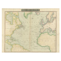

Interesting Map of the Atlantic Showing Nelson's and Trade Routes, 1817
$521Sale Price|20% Off
Interesting Map of the Atlantic Showing Nelson's and Trade Routes, 1817
By John Thomson
Located in Langweer, NL
Antique map titled 'Chart of the North Atlantic Ocean with Tracks of the Shipping to West Indies, North America, &cc'. Large map of the Atlantic, showing the tracks of the ships trad...
Category
19th Century Antique John Thomson Furniture
Materials
Paper