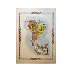
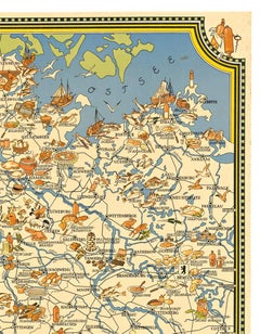
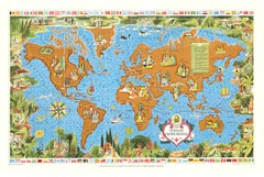
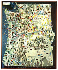
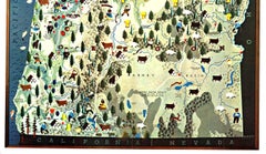
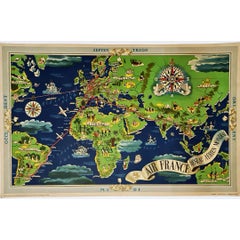
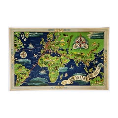
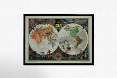
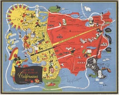
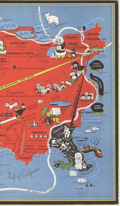
Map Prints and Multiples

to
25
122
142
68
34
22
Overall Width
to
Overall Height
to
160
24
18
3
1
1
30
28
11
11
9
122
128
122
16
1
1
3
18
34
29
7
12
5
2
27
277
111
462
39,558
20,745
13,983
12,786
11,423
9,207
7,974
5,902
4,419
3,899
3,713
3,675
3,579
3,524
3,243
3,231
2,877
2,737
2,575
152
135
100
68
25
27
216
274
70
Art Subject: Map
Original 'Map of the United States as Californians See It' vintage map poster

Original 'Map of the United States as Californians See It' vintage map poster

Located in Spokane, WA

Original vintage poster: "Map of the United States as Californians See It". 1947, artist: Oren Arnold. Size: 16.5" x 20.5", R. H. MOEBUS COMPANY This poster is not linen-backed. This poster is in very good fine condition, ready to frame. A humorous satirical pictorial map from 1947 with the golden sun on the upper left, gives a detailed depiction of California, its relative size to the rest of the United States, showing Florida as "Death Valley", the rest of the United States as "Unexplored" 'Unimportant anyway, not in California". The image has your Mexican singer; bikini-clad bathers and others set in the image. Shows rivers, lakes, harbors, landmarks, parks, recreational activities, and local people. This map shows Los Angeles’ city...

Category

1940s American Modern Landscape Prints

Materials

Offset

Original 1960 Map by Louis Dressen État du Katanga Congo

Original 1960 Map by Louis Dressen État du Katanga Congo

Located in PARIS, FR

This original 1960 poster by Louis Dressen, titled État du Katanga, is a rare and powerful visual document from one of the most turbulent moments in post-colonial African history. Pu...

Category

1960s Prints and Multiples

Materials

Paper, Lithograph

Jacques Liozu's 1951 illustrated map of South America

Jacques Liozu's 1951 illustrated map of South America

By Jacques Liozu

Located in PARIS, FR

Jacques Liozu's 1951 illustrated map of South America is an exceptional work of cartography that skilfully blends art and geography. French artist and cartographer Jacques Liozu crea...

Category

1950s Prints and Multiples

Materials

Paper, Lithograph

Reflection, Surrealist Etching with Aquatint by Jean Solombre

Reflection, Surrealist Etching with Aquatint by Jean Solombre

Located in Long Island City, NY

Jean Solombre, French (1948 - ) - Reflection, Year: 1980, Medium: Etching with Aquatint on Arches, signed, numbered and dated in pencil, Edition: 19/125, Image Size: 11 x 11 inch...

Category

1980s Surrealist Landscape Prints

Materials

Etching, Aquatint

AMERICA
AMERICA

John SpeedAMERICA, 1626-76

$4,250Sale Price|50% Off

AMERICA

By John Speed

Located in Santa Monica, CA

IMPORTANT AMERICAN MAP - ONE OF THE FIRST TO SHOW CALIFORNIA as an ISLAND JOHN SPEED (1552-1629) AMERICA - With Those Known Parts In That Unknown Worlde (sic), 1626-(76) (Burden 217 iv/iv) Engraving, uncolored. Engraved by Abraham Goos and published by Thomas Basset and Richard Chiswell - 4th state of 4 in 1676.15 1/8 x 20 1/2” From “A Prospect of the Most Famous Parts of the World”. Generally good condition. A repaired split in lower centerfold. This is the most common version of this important map...

Category

1620s Old Masters Landscape Prints

Materials

Engraving

Australia, Tallis antique map, 1851

Australia, Tallis antique map, 1851

Located in Melbourne, Victoria

'Australia' With decorative border surrounds and vignettes including a view of Sydney, Kangaroos, Natives of Australia Felix, Australian Parrots and Cockatoos and Natives of the Tri...

Category

19th Century Naturalistic Landscape Prints

Materials

Engraving

Heaven of Jupiter - Woodcut  - 1963

Heaven of Jupiter - Woodcut - 1963

By Salvador Dalí­

Located in Roma, IT

Heaven of Jupiter is a woodcut print realized in 1963 for a series illustrating the Medieval poem of the "Divine Comedy" by Dante Alighieri. Not signed, as issued. Plate n.20 (as...

Category

1960s Surrealist Figurative Prints

Materials

Woodcut

1950 illustrated map Italy, Land of Saints and Sanctuaries

1950 illustrated map Italy, Land of Saints and Sanctuaries

Located in PARIS, FR

In 1950, a highly detailed and artistically illustrated map titled Italie Terre de Saints et de Sanctuaires (Italy, Land of Saints and Sanctuaries) was published in Témoignage Chréti...

Category

1950s Prints and Multiples

Materials

Linen, Paper, Lithograph

1851 Original map by Maillard - Plan de Paris et ses Fortifications

1851 Original map by Maillard - Plan de Paris et ses Fortifications

Located in PARIS, FR

In the world of cartography, maps transcend mere geography; they are historical records and works of art, encapsulating the essence of a place at a specific moment in time. The 1851 ...

Category

1850s Prints and Multiples

Materials

Linen, Paper, Lithograph

Durham, English County Antique map, 1847

Durham, English County Antique map, 1847

By Isaac Slater

Located in Melbourne, Victoria

Steel-engraved map with original outline colouring by Isaac Slater. A detailed engraved map of the English county with title, scale, and key. Decorated with an uncoloured engraved vi...

Category

19th Century Naturalistic Landscape Prints

Materials

Engraving

Original 'Bundesbahn durch das Gastliches Deutschland' vintage poster

Original 'Bundesbahn durch das Gastliches Deutschland' vintage poster

Located in Spokane, WA

Linen-backed original German / Germany culinary map in excellent condition. MIT DER DEUTSCHEN BUNDESBAHN DURCH DAS GASTLICHE DEUTSCHLAND. Mit der Deutschen Bundesbahn durch das Gastliche Deutschland (With Deutsche Bundesbahn through Hospitable Germany). A map of Germany showing all the food and wine features in various regions and cities. If you go to Germany and want to find the origins of foods, this will lead you to the correct city. From wine, bread, fish, cookies, spat, prezels, pork, bier, french...

Category

1950s American Modern Landscape Prints

Materials

Lithograph

Map of Chatham, Cape Cod

Map of Chatham, Cape Cod

Located in New York, NY

Original map of Chatham, Cape Cod, with recent hand-coloring, 1938. Light toning to edges; has original holes punched in left edge. From "Massachusetts Cit...

Category

1930s Prints and Multiples

Materials

Paper

Giambattista Nolli Rome 1748 Offset Print, Aerial Map, 1997 Edition

Giambattista Nolli Rome 1748 Offset Print, Aerial Map, 1997 Edition

Located in Brooklyn, NY

This poster presents a one-half scale reduction of Giambattista Nolli’s celebrated Pianta Grande di Roma (Great Plan of Rome), originally engraved in 1748 after years of surveying th...

Category

1990s Prints and Multiples

Materials

Offset

Circa 1950 poster Air Algérie regular line network

Circa 1950 poster Air Algérie regular line network

Located in PARIS, FR

The circa 1950 poster Air Algérie, réseau des lignes régulières by C. Rivière is a vibrant and captivating piece of mid-century commercial art that illustrates the network of regular...

Category

1950s Prints and Multiples

Materials

Linen, Paper, Lithograph

World Map - Etching by Hubert Nicholas-Jaillot - 1719

World Map - Etching by Hubert Nicholas-Jaillot - 1719

Located in Roma, IT

World map is an original modern artwork realized by Hubert Nicholas - Jaillot, printed by Louis Cordier in  Paris 1719. Etching on copper The artwork depicts two hemispheres, conti...

Category

1710s Old Masters Figurative Prints

Materials

Etching

1935 original map French exploration in North America

1935 original map French exploration in North America

Located in PARIS, FR

In 1935, a remarkable map titled "Les Français au Cœur de l'Amérique" was produced, highlighting the rich history of French exploration and influence in North America. This map is a ...

Category

1930s Prints and Multiples

Materials

Paper, Lithograph

18th-century celestial - Eridanus Orion Lepus

18th-century celestial - Eridanus Orion Lepus

Located in London, London

18th-century celestial FLAMSTEED, John. Eridanus Orion Lepus London, C. Nourse, 1753. A fine star chart from the Atlas Coelestis, the largest and most accurate star atlas publish...

Category

1750s Naturalistic Figurative Prints

Materials

Watercolor, Engraving

18th-century celestial - Andromeda Perseus Triangulum

18th-century celestial - Andromeda Perseus Triangulum

Located in London, London

18th-century celestial FLAMSTEED, John. Andromeda Perseus Triangulum London, C. Nourse, 1753. A fine star chart from the Atlas Coelestis, the largest and most accurate star atlas ...

Category

1750s Naturalistic Figurative Prints

Materials

Watercolor, Engraving

Cambridgeshire map 17th century engraving by John Speed

Cambridgeshire map 17th century engraving by John Speed

By John Speed

Located in London, GB

To see more, scroll down to "More from this Seller" and below it click on "See all from this Seller." John Speed (1551 or 1552 - 1629) Map of Cambridgeshire Engraving with later hand colouring 39 x 53 cm A beautifully coloured map of Cambridgeshire, with an antique description...

Category

1610s Landscape Prints

Materials

Engraving

Australia Original Vintage Propaganda Poster post WW2 MacDonald Max Gill

Australia Original Vintage Propaganda Poster post WW2 MacDonald Max Gill

By "Leslie MacDonald ""Max"" Gill"

Located in London, GB

To see our other original vintage travel and propaganda posters, scroll down to "More from this Seller" and below it click on "See all from this Seller" - or send us a message if you...

Category

1940s Modern Landscape Prints

Materials

Lithograph

Map of Africa - Original Etching by C. Brue - 1820

Map of Africa - Original Etching by C. Brue - 1820

Located in Roma, IT

Map of Africa is an original etching realized by C.Brue in 1820. The print comes from the Series "Atlas Universal" PL. 31. The state of preservation of the artwork is good except f...

Category

1820s Modern Figurative Prints

Materials

Etching

LONG STANDING #2

LONG STANDING #2

By Rebecca Baird

Located in Aventura, FL

Lithograph on paper. Sheet size 19 x 12 inches. Hand signed, dated and numbered by the artist. Edition of 300. Certificate of Authenticity Included. Artwork in Excellent Conditi...

Category

Late 20th Century Contemporary Figurative Prints

Materials

Paper, Lithograph

Original 1940 Washington & Oregon Pictorial Map vintage poster

Original 1940 Washington & Oregon Pictorial Map vintage poster

Located in Spokane, WA

Map of historical landmarks, American Indian territories, rivers, mountains, dams, colleges, federal grazing districts, cities, agriculture, and other activities that were present in...

Category

1940s American Realist Landscape Prints

Materials

Offset

Circa 1950 original poster by Luc-Marie Bayle for TAI - World map

Circa 1950 original poster by Luc-Marie Bayle for TAI - World map

By Lue Marie Bayle

Located in PARIS, FR

This circa 1950 original poster, created by Luc-Marie Bayle, celebrates the global reach of TAI (Transports Aériens Intercontinentaux), one of France’s pioneering airline companies. ...

Category

1950s Prints and Multiples

Materials

Paper, Lithograph

Le Coste Nord Ovest Dell' America E Nord Est Dell' Asia Delineate Sulle Ultime O

Le Coste Nord Ovest Dell' America E Nord Est Dell' Asia Delineate Sulle Ultime O

Located in Bristol, CT

Map Sz: 14 1/2"H x 19 7/8"W Frame Sz: 21"H x 26 3/8"W A fine example of Cassini's 1798 map of Alaska, the Bering Strait, and Siberia. Cassini issued this map in his 1798 atlas to illustrate the discoveries made by James Cook. Cook was the first to accurately chart the Alaskan coastline and provide a detailed mapping of the Aleutian Islands. Cook's zigzagging route is shown as he skirts the Aleutian Islands, passes through the Bering Strait into the Arctic Ocean, and then turns back to sail south along the Siberian Coast. Here the Aleutians are collectively identified as Isole Alessiane, though many of the original islands...

Category

1790s Prints and Multiples

Materials

Paper

England and the British Isles: A Large 17th Century Hand-colored Map by de Wit

England and the British Isles: A Large 17th Century Hand-colored Map by de Wit

By Frederick de Wit

Located in Alamo, CA

This is a large hand-colored 17th century map of England and the British Isles by Frederick de Wit entitled "Accuratissima Angliæ Regni et Walliæ Principatus", published in Amsterdam in 1680. It is a highly detailed map of England, Scotland, the Scottish Isles...

Category

Late 17th Century Other Art Style Landscape Prints

Materials

Engraving

PERU
PERU

PERU

By Johannes Jansson

Located in Santa Monica, CA

JOHANNES JANSSON (1588 - 1664) PERU, engraving with early coloring. Platemark 15 1/8 x 19 3/8 inches, sheet 17 x 20 1/2 A nice example of one of the earliest maps of Peru. From the ...

Category

1630s Old Masters Landscape Prints

Materials

Engraving

Original Ireland Pictorial Vintage Poster Travel Map  linen backed

Original Ireland Pictorial Vintage Poster Travel Map linen backed

Located in Spokane, WA

Original Ireland Pictorial Map, archival linen-backed, Grade A, ready to frame. This poster has no restoration, vibrant colors, and numerous details. Browne and Nolan Limited printed...

Category

1970s American Modern Landscape Prints

Materials

Lithograph

Original poster, titled “L’Europe Nouvelle” - political map of Europe

Original poster, titled “L’Europe Nouvelle” - political map of Europe

Located in PARIS, FR

This fascinating original poster, titled “L’Europe Nouvelle”, presents a vivid political map of Europe and the world as reshaped by the Treaty of Versailles, signed in 1919 at the co...

Category

1910s Prints and Multiples

Materials

Linen, Paper, Lithograph

Dépt. De L’Ariège, & Dépt. De la Vendée, from Atlas National de France Illustré

Dépt. De L’Ariège, & Dépt. De la Vendée, from Atlas National de France Illustré

By Louis Francois Couche

Located in Middletown, NY

Two (2) historiated engraved maps, each 11 1/4 x 16 7/16 inches (285 x 418 mm) with handcoloring, on wove paper, the latter engraved by C. Smith after Couché fils, published by Combe...

Category

Mid-19th Century French School Landscape Prints

Materials

Watercolor, Handmade Paper, Engraving

Map of Lombardy - Original Etching - 19th Century

Map of Lombardy - Original Etching - 19th Century

Located in Roma, IT

The Map of Lombardy is an original etching realized by an anonymous artist. Fair conditions, the folding line of the middle is repaired. The artwork represents the map of Lombardo....

Category

19th Century Modern Figurative Prints

Materials

Etching

1899 "Plan des Tramways de Paris" by Wuhrer - Paris's public transportation

1899 "Plan des Tramways de Paris" by Wuhrer - Paris's public transportation

Located in PARIS, FR

The 1899 "Plan des Tramways de Paris" by Wuhrer is a fascinating snapshot of Paris's public transportation landscape at the dawn of the 20th century. This meticulously crafted map delineates the extensive network of tramway lines that crisscrossed the city, each route marked in detail to aid both residents and visitors in navigating the bustling metropolis. The Belle Époque, during which this map was produced, was a period of significant growth and modernization in Paris. The city's population was expanding rapidly, and with it came the need for a more efficient means of urban transport. Tramways emerged as a vital solution, connecting neighborhoods and making the city's many attractions more accessible. These electric trams were a symbol of technological progress, replacing the horse-drawn carriages of earlier years and setting the stage for the future of public transit...

Category

1890s Prints and Multiples

Materials

Paper, Lithograph

Circa 1950 airline poster by Luc-Marie Bayle - TAI Planisphère

Circa 1950 airline poster by Luc-Marie Bayle - TAI Planisphère

Located in PARIS, FR

This enchanting original circa 1950 airline poster by French naval officer and artist Luc-Marie Bayle was created for TAI (Transports Aériens Intercontinentaux), one of France’s most prestigious intercontinental airlines prior to its merger into UTA. The poster presents a richly illustrated planisphère (world map), delicately blending cartographic accuracy with whimsical fantasy. Bayle’s meticulous hand creates a double-hemisphere projection filled with lively imagery: from hot-air balloons and caravels to mythical creatures, medieval compass roses, and aeronautical routes in vibrant red and blue lines tracing TAI’s global flight network. Above the map sits the golden-winged TAI insignia, flanked by vintage flying machines...

Category

1950s Prints and Multiples

Materials

Paper, Lithograph

1937 original poster illustrated map of the Exposition Internationale

1937 original poster illustrated map of the Exposition Internationale

Located in PARIS, FR

This 1937 original poster presents a detailed illustrated map of the Exposition Internationale des Arts et Techniques dans la Vie Moderne, held in Paris. The International Exposition...

Category

1930s Prints and Multiples

Materials

Paper, Lithograph, Linen

Original San Francisco, California vintage fun map poster  Henry Hinton

Original San Francisco, California vintage fun map poster Henry Hinton

Located in Spokane, WA

Original San Francisco, California fun map vintage poster 1970. Archival linen backed in very fine condition, ready to frame. -Artist: Henry Hinton I don’t know how much more you could include in this detailed fun map of San Francisco...

Category

1970s American Impressionist Landscape Prints

Materials

Offset