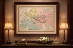
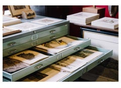
Amstelredam - Etching by Johannes Janssonius - 1650s
By Johannes Janssonius
Located in Roma, IT
Amstelredam is an ancient map realized in 1650 by Johannes Janssonius (1588-1664).
Category
1650s Modern Figurative Prints
Materials
Etching
Amstelredam - Etching by Johannes Janssonius - 1650s
By Johannes Janssonius
Located in Roma, IT
Amstelredam is an ancient map realized in 1650 by Johannes Janssonius (1588-1664).
Etching
Amstelredam - Etching by Johannes Janssonius - 1650s
By Johannes Janssonius
Located in Roma, IT
Amstelredam is an ancient map realized in 1650 by Johannes Janssonius (1588-1664).
Etching
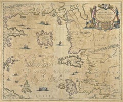
Barbarga Etching, Hand Watercolored, 1650, Modern Style, Unframed
By Johannes Janssonius
Located in Roma, IT
Barbarga is an ancient map realized in 1650 by Johannes Janssonius (1588-1664).
Etching
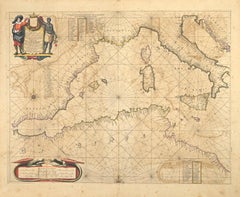
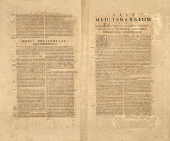
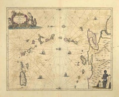
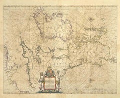
Maris Mediterranei - Etching by Johannes Janssonius - 1650s
By Johannes Janssonius
Located in Roma, IT
Maris Mediterranei is an ancient map realized in 1650 by Johannes Janssonius (1588-1664).
Etching
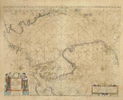
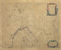
Oceani Borealis - Etching by Johannes Janssonius - 1660s
By Johannes Janssonius
Located in Roma, IT
Oceani Borealis is an ancient map realized in 1650 by Johannes Janssonius (1588-1664).
Etching
$2,089
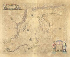
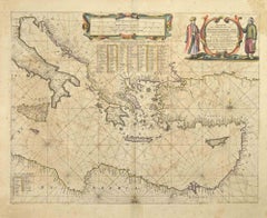
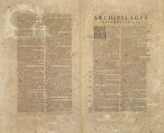
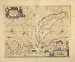
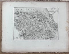
Archipelagus Septentrionalis - Etching by Johannes Janssonius - 1650s
By Johannes Janssonius
Located in Roma, IT
Archipelagus Septentrionalis is an ancient map realized in 1650 by Johannes Janssonius (1588-1664).
Etching
S.Juan de Puerto Rico - Etching by Johannes Janssonius - 1650s
By Johannes Janssonius
Located in Roma, IT
S.Juan de Puerto Rico is an ancient map realized in 1650 by Johannes Janssonius (1588-1664).
Etching
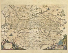

Achaiae Noua - Etching by Johannes Janssonius - 1650s
By Johannes Janssonius
Located in Roma, IT
Achaiae Noua is an ancient map realized in 1650 by Johannes Janssonius (1588-1664).
Etching

Mare Atlanticum - Etching by Johannes Janssonius - 1650s
By Johannes Janssonius
Located in Roma, IT
Mare Atlanticum is an ancient map realized in 1650 by Johannes Janssonius (1588-1664).
Etching
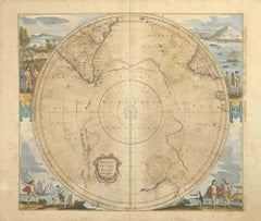
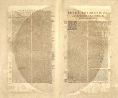
Polus Antarcticus - Etching by Johannes Janssonius - 1650s
By Johannes Janssonius
Located in Roma, IT
Polus Antarcticus is a top rare ancient map realized in 1650 by Johannes Janssonius (1588-1664).
Etching
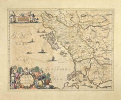
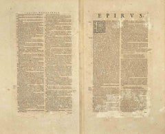
Epirus Albania - Etching by Johannes Janssonius - 1650s
By Johannes Janssonius
Located in Roma, IT
Epirus Albania is an ancient map realized in 1650 by Johannes Janssonius (1588-1664).
Etching
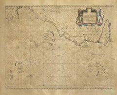
Freti Canalis - Etching by Johannes Janssonius - 1650s
By Johannes Janssonius
Located in Roma, IT
Freti Canalis is an ancient map realized in 1650 by Johannes Janssonius (1588-1664).
Etching
Nova Zemla - Etching by Johannes Janssonius - 1650s
By Johannes Janssonius
Located in Roma, IT
Nova Zemla is an ancient map realized in 1650 by Johannes Janssonius (1588-1664).
Etching
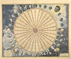
Anemogra Phica - Etching by Johannes Janssonius - 1650s
By Johannes Janssonius
Located in Roma, IT
Anemogra Phica is a rare ancient map realized in 1650 by Johannes Janssonius (1588-1664).
Etching
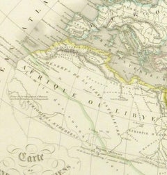
Ancient World Map
Located in Houston, TX
Over 150 year old engraved map of the world as it was known during the antiquities by cartographer Delamarche from 1838. Original hand color. Shows African, European and Asian cont...
Ink, Watercolor, Handmade Paper


$6,966
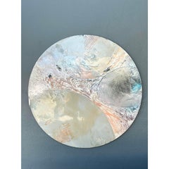
Urban Chronos: Abstract Painting in Oil and Acrylic, 100x120 cm
Located in Zofingen, AG
The composition feels like an ancient map or a decoded signal of a city that never sleeps.
Oil, Acrylic


Cartografía del recuerdo
Located in Barcelona, CT
The tactile surface suggests a layered technique, resembling a worn fresco or ancient map, inviting viewers to explore its intricate details.
Canvas, Mixed Media
$15,000
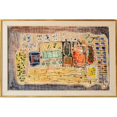
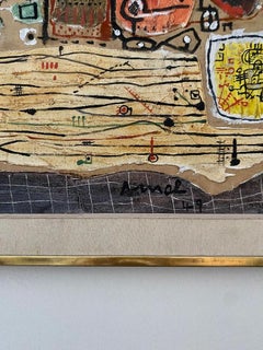
La Gare
By François Arnal
Located in Boca Raton, FL
The layered surface and carefully balanced composition evoke the appearance of an ancient map, coded manuscript, or archaeological fragment, inviting close examination and interpreta...
Canvas, Oil
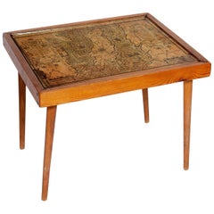
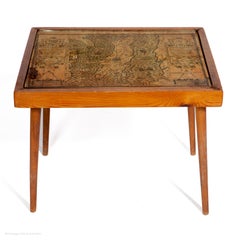
Table Low Sofa Vintage 1950s Map Isle of Man John Speed 1610 Thomas Durham 1595
Located in BUNGAY, SUFFOLK
- The juxtaposition of modern design and this ancient map create a unique small table and conversation piece - This is the first map featuring the Isle of Man on its own
Paper
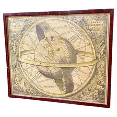
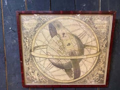
Ancient engraving, map of the earth with circling zodiac
Located in Mouscron, WHT
Ancient engraving, map of the earth with circling zodiac "Situs Terrae Circulis Coelestibus Circumnate"
Paper
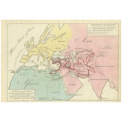
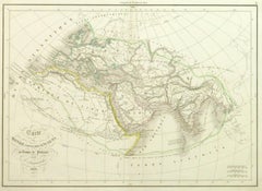
Ancient World Map, Roman Macedonian Persian Empires, Ferrario 1815
Located in Langweer, NL
Antique Map of Asia 1815 – Carta Generale dell’Asia, Ferrario, Italy This refined early 19th-century map presents a comprehensive view of the Asian continent, titled Carta Generale ...
Paper
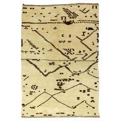

Modern Moroccan Style Abstract Wool Rug – Artisan Geometry by Doris Leslie Blau
By Doris Leslie Blau
Located in New York, NY
The visual effect is both meditative and dynamic, as if tracing the memory of an ancient map or coded textile language. Woven from high-quality wool, the rug delivers luxurious soft...
Wool

Map of Ancient Greece - Original Etching by Antonio Zatta - 1785
By Antonio Zatta 1
Located in Roma, IT
This Map of ancient Greek is an etching realized by Antonio Zatta in Venice in 1785.
Etching
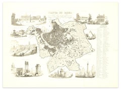
Map of Ancient Rome - Original Etching by Alessandro Moschetti - 1848
By Alessandro Moschetti
Located in Roma, IT
Plan of Rome is a beautiful original black and white etching, a rare and antique illustrated map of the eternal city of Rome, published in 1848. Image Dimensions: 29.5 x 43 cm Orig...
Etching
$161Sale Price|20% Off
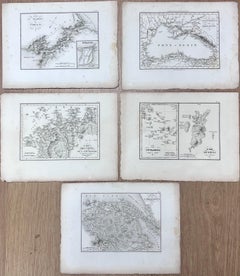
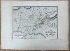
Collection of Five Antique Maps Depicting Ancient Greek and Anatolian Regions
Located in Cirencester, Gloucestershire
Collection of Five Antique Maps each drawing : 9 x 12 inches provenance: private collection condition: very good and sound condition Description: This set of five finely detailed an...
Pencil
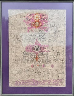
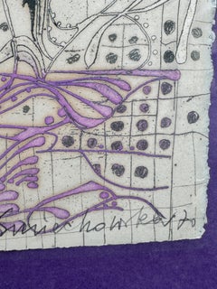
Letter From Vienna Color Etching 3/60
By Krystyna Smiechowska
Located in Lake Worth Beach, FL
Printmaker Krystyna Smiechowska draws her inspiration from ancient maps and inscriptions and Slavic manuscripts from the High Middle Ages.
Etching, Archival Paper
Maps of the Ancient World and the Posterity of Noah, 1820
Located in Langweer, NL
Two maps on one sheet. Hhand colored engraved lithograph, depicting the world as known to the Ancients on Mercator's projection and the Posterity of Noah. The first showns the Empire...
Paper

$348
Map of Ancient Greece of Macedonia and... - Lithograph by Auguste Wahlen - 1844
By Auguste Wahlen
Located in Roma, IT
Map of Ancient Greece of Macedonia and Thrace is a lithograph made by Auguste Wahlen in 1844.
Lithograph
$183Sale Price|20% Off
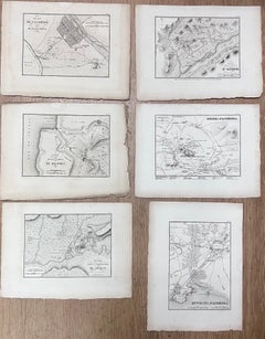
Set of Six Antique Engravings Historical Plans Maps of Ancient Greek Cities
Located in Cirencester, Gloucestershire
Set of Six Antique Engravings each drawing : 9 x 12 inches provenance: private collection condition: very good and sound condition Description: This collection of six antique engrav...
Pencil
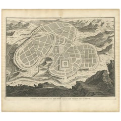
Antique Map of the Ancient City of Jerusalem by A. Calmet, 1725
Located in Langweer, NL
Antique map, titled: 'Nieuwe Plattegrond van het Oude Jeruzalem Volgens den Schryver.' - Bird's-eye view of the ancient city of Jerusalem shows its divisions with prominent depiction...
Paper
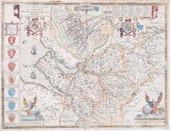
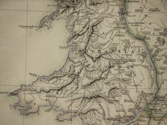
John Speede Map The Countye Palatine of Chester with that most ancient citie
By John Speed
Located in London, GB
John Speed/Speede (1551/2-1629) The Countye Palatine of Chester with that most ancient citie described Performed by John Speede assisted by William Smyth.
Engraving
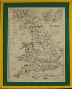
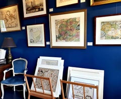
"Britannia"
Located in Bristol, CT
Weller for Dr William Smith's 'Ancient Atlas' plate No. 10 Map Sz: 22 1/2"H x 17 3/8"W Frame Sz: 27 1/8"H x 22"W
Paper

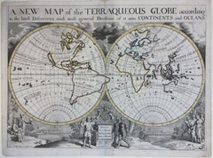
New Map of the Terraqueous Globe - WORLD MAP - CALIFORNIA AS AN ISLAND
By Edward Wells
Located in Santa Monica, CA
A decorative view featuring Oxford. From "A New Sett of Maps both of Ancient and Present Geography". The atlas compiled by mathematician and geographer Edward Wells (1667-1727) and ...
Engraving
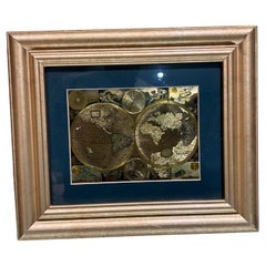
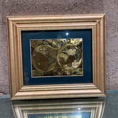
Late 20th Century Gold Foil World Map Double Hemisphere
Located in Chula Vista, CA
Late 20th Century Gold Foil Ancient World Map Double Hemisphere Gold Foil Old World Framed Map information on reverse of the print.
Gold
Monumental Design with World Map Pillar – Engraving after Volckamer, c.1780
Located in Langweer, NL
At its center stands the so-called *Columna Milliaria*, a column believed to reference or metaphorically embody the Roman Tabula Peutingeriana – the famous ancient Roman map depictin...
Paper

$139Sale Price|20% Off
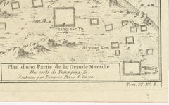
1749 Jacques Nicolas Bellin Map of the Great Wall of China Near Kiang-nan fu
Located in Langweer, NL
Built by Ancient War Planters." The map showcases the detailed topography around segments of the Great Wall and labels various sections and nearby locations.
Paper

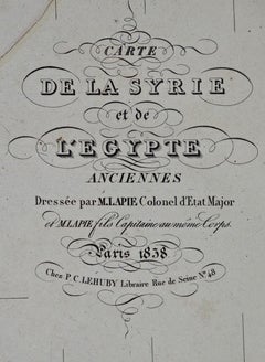
Map of the Holy Land "Carte de la Syrie et de l'Egypte" by Pierre Lapie
By Pierre M. Lapie
Located in Alamo, CA
This is an early 19th century map of ancient Syria and Egypt entitled "Carte de la Syrie et de l'Egypte anciennes/dressée par M.
Engraving
Vintage Monumental Mixed Media Disc Wall Sculpture
Located in West Palm Beach, FL
The interplay of cool grays, warm terracotta, and subtle teal highlights creates a dynamic surface that shifts with the light, evoking the sublime beauty of lunar surfaces or ancient...
Resin, Wood


Large Boulder Koroit Opal Silver Ring 9ct opal anniversary gift
Located in Berlin, DE
The large 9-carat opal displays an intricate natural matrix - a network of glowing, ribbon-like formations reminiscent of ancient continental maps, deep riverbeds, and mineral veins ...
Opal, 18k Gold, Gold Plate, Silver
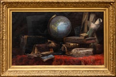
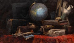
Allegory of Geography
Located in Paris, IDF
A globe sits at the center of the composition, surrounded by ancient books, maps, and manuscripts, evoking exploration, cartography, and the transmission of knowledge.
Oil

$522
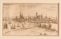
View of Rostock - Etching by G. Braun and F. Hogenberg - 16th Century
By Franz Hogenberg
Located in Roma, IT
The Map of Rostock (ancient name: Rostochivm) is an original etching realized by George Braun (1541 – 1622) The state of preservation of the artwork is good but aged .
Etching
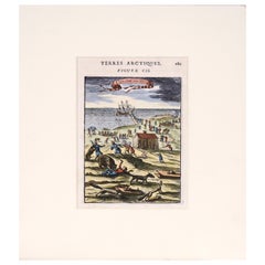
Rare Hand Colored "Cabane Des Hold" - 1st Ed "Description de l’Univers" C. 1683
By Alain Manesson Mallet
Located in Soquel, CA
He is best known for his extensive work Description de L'Univers (1683) in 5 volumes, a copious publication which contains maps of all parts of the then-known world (both ancient and...
Paper, Ink, Gouache
$157Sale Price|20% Off
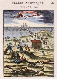
Two Antique Views of the Ruins of the Tower of Babel, Babylon, 1683
Located in Langweer, NL
His Description de L'Universe contains a wide variety of information, including star maps, maps of the ancient and modern world, and a synopsis of the customs, religion and governmen...
Paper
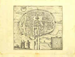
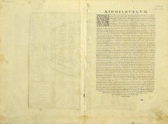
View of Middelburg - Etching by G. Braun and F. Hogenberg - Late 1500
By Franz Hogenberg
Located in Roma, IT
This map of Middelburg (ancient name: Middelbvrgvm) is an original etching realized by George Braun and Franz Hogenberg as part of the famous Series "Civitates Orbis Terrarum".
Etching
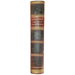
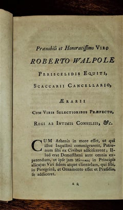
Demosthenis Selectae Orationes by Richard Mounteney 1791 7th Edition
Located in Dallas, TX
Title: Demosthenis Selectae Orationes Ad Codices … Publisher: J.Pote, J.Rivington et Filios, London Publication Date: 1791 Binding: Full-Leather Book condition: Very good...
Leather, Paper


The Anatolian Cipher: A Modern Oushak Masterpiece of Bohemian Tribal Elegance
Located in Dallas, TX
Their placement frames the striking composition with an intentional sense of order, creating the impression of an ancient emblematic map rendered through a modern lens.
Wool