
Authentic Antique Maps

8
to
106
1,973
28
1,143
857
765
360
23
16
13
9
4
4
4
4
3
2
1
1
1
1
1
1
1
1
1
1
1
1
1
1
1
1
31
17
13
13
13
Sort By
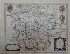
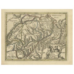
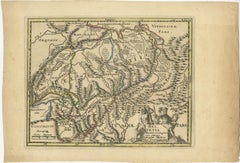
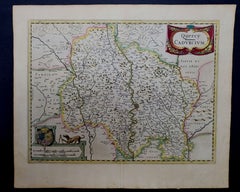
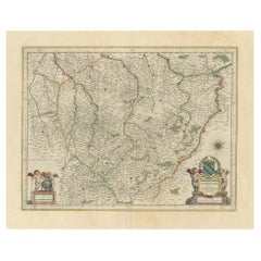
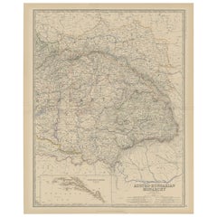
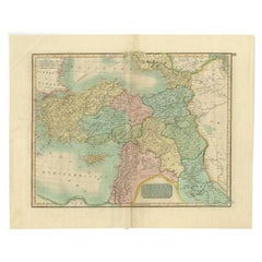
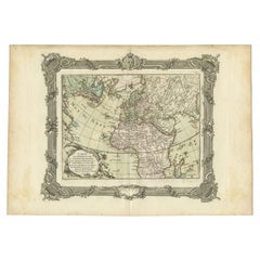
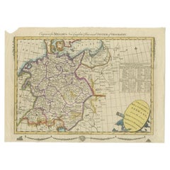
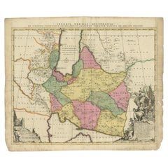
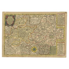
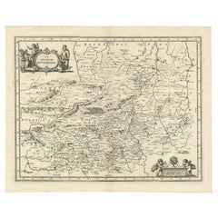
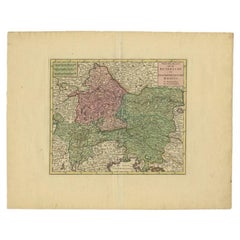
Attractive Detailed Authentic Map Showing Bavaria, Germany and Austria, c.1740
Located in Langweer, NL
Antique map titled 'Nieuwe Kaart van de Beyersche en Oostenryksche Kreits (..).' Attractive
Category

18th Century Authentic Antique Maps

Materials

Paper

Authentic Map of the Coast from Cape Formosa to the Dony River, Africa, 1732
Located in Langweer, NL
Antique map titled 'The New Correct Mapp of Calbar River vulgarly call'd Calabar (..)'. An
Category

1730s Authentic Antique Maps

Materials

Paper

Rare Large Map of Florida, the Gulf Coast, Caribbean & Central America, c1728
Located in Langweer, NL
(..) - Nieuwe groote en seer Curieuse Paskaart van Geheel-WestIndien' (..). Beautiful authentic map of Florida
Category

Mid-18th Century European Authentic Antique Maps

Materials

Paper

1656 Jansson Map Metz Region of France Entitled "Territorium Metense" Ric0014
Located in Norton, MA
1656 Jansson map Metz Region of France entitled "Territorium Metense." Ric0014 " Authentic
Category

17th Century Dutch Authentic Antique Maps

Materials

Paper

Genuine Antique Engraved Map of Helvetia or Switzerland, 1729
Located in Langweer, NL
Absolutely Original authentic Maps and Prints. A Certificate of Authenticity ( COA ) will be supplied on
Category

1720s Authentic Antique Maps

Materials

Paper

Old Map of Southern Australia, with an Inset Map of Cape York Peninsula, 1882
Located in Langweer, NL
Modern Geography, Exhibiting, in a Series of Entirely Original and Authentic Maps, the Present Condition
Category

1880s Authentic Antique Maps

Materials

Paper

Old Original Antique Map of Western Canada, 1882
Located in Langweer, NL
'The Royal Atlas of Modern Geography, Exhibiting, in a Series of Entirely Original and Authentic Maps
Category

1880s Authentic Antique Maps

Materials

Paper

Antique Map of North America by Johnston, 1882
By Alexander Keith Johnston
Located in Langweer, NL
Atlas of Modern Geography, Exhibiting, in a Series of Entirely Original and Authentic Maps, the Present
Category

19th Century Authentic Antique Maps

Materials

Paper

  • Antique Map of North America by Johnston, 1882
  • Antique Map of North America by Johnston, 1882
  • Antique Map of North America by Johnston, 1882
  • Antique Map of North America by Johnston, 1882
H 24.18 in. W 19.49 in. D 0 in.
Old Map of Southern India and Ceylon 'Sri Lanka', 1882
Located in Langweer, NL
Modern Geography, Exhibiting, in a Series of Entirely Original and Authentic Maps, the Present Condition
Category

1880s Authentic Antique Maps

Materials

Paper

  • Old Map of Southern India and Ceylon 'Sri Lanka', 1882
  • Antique Old Map of Southern India and Ceylon 'Sri Lanka', 1882
  • Old Map of Southern India and Ceylon 'Sri Lanka', 1882
  • Antique Old Map of Southern India and Ceylon 'Sri Lanka', 1882
Free Shipping
H 19.53 in. W 24.34 in. D 0 in.
Antique Map of the United States of North America, c.1882
Located in Langweer, NL
Original and Authentic Maps, the Present Condition of Geographical Discovery and Research in the Several
Category

1880s Authentic Antique Maps

Materials

Paper

Old Map of Turkey in Europe, incl Romania, Servia, Montenegro & Bulgaria, 1882
Located in Langweer, NL
Entirely Original and Authentic Maps, the Present Condition of Geographical Discovery and Research in the
Category

1880s Authentic Antique Maps

Materials

Paper

Old Map of Southern Russia, Incl the Extent of the Kingdom of Poland, 1882
Located in Langweer, NL
Series of Entirely Original and Authentic Maps, the Present Condition of Geographical Discovery and
Category

1880s Authentic Antique Maps

Materials

Paper

Map of Southern Italy inlcluding Sardinia and Inset of the Bay of Naples, c.1860
Located in Langweer, NL
Geography Exhibiting, In A Series Of Entirely Original And Authentic Maps, The Present Condition Of
Category

1860s Authentic Antique Maps

Materials

Paper

Antique Map of Belgium and the Netherlands by Johnston, 1882
By Alexander Keith Johnston
Located in Langweer, NL
Authentic Maps, the Present Condition of Geographical Discovery and Research in the Several Countries
Category

19th Century Authentic Antique Maps

Materials

Paper

Antique Map of Central America and the West Indies, 1882
Located in Langweer, NL
Entirely Original and Authentic Maps, the Present Condition of Geographical Discovery and Research in the
Category

19th Century Authentic Antique Maps

Materials

Paper

Antique Map of Eastern Canada with an inset Map of Newfoundland, 1882
Located in Langweer, NL
Entirely Original and Authentic Maps, the Present Condition of Geographical Discovery and Research in the
Category

19th Century Authentic Antique Maps

Materials

Paper

Antique Map of China and an Inset Map of Japan, 1882
Located in Langweer, NL
Entirely Original and Authentic Maps, the Present Condition of Geographical Discovery and Research in the
Category

19th Century Authentic Antique Maps

Materials

Paper

Old Coloure Map of North & Central Italy & Corsica with an Inset of Rome, c.1860
Located in Langweer, NL
Royal Atlas Of Modern Geography Exhibiting, In A Series Of Entirely Original And Authentic Maps, The
Category

1860s Authentic Antique Maps

Materials

Paper

Antique Map of New Zealand by Scottish Geographer Johnston, 1882
Located in Langweer, NL
Atlas of Modern Geography, Exhibiting, in a Series of Entirely Original and Authentic Maps, the Present
Category

19th Century Authentic Antique Maps

Materials

Paper

  • Antique Map of New Zealand by Scottish Geographer Johnston, 1882
  • Antique Map of New Zealand by Scottish Geographer Johnston, 1882
  • Antique Map of New Zealand by Scottish Geographer Johnston, 1882
  • Antique Map of New Zealand by Scottish Geographer Johnston, 1882
Free Shipping
H 24.18 in. W 19.53 in. D 0 in.
Antique Map of North and South Africa by Johnston, 1882
Located in Langweer, NL
, Exhibiting, in a Series of Entirely Original and Authentic Maps, the Present Condition of Geographical
Category

19th Century Authentic Antique Maps

Materials

Paper

1643 Willem&Joan Blaeu Map NW Flanders "Flandriae Teutonicae Pars Prientalior
Located in Norton, MA
Prientalior," Ric0012 " Authentic" - Map of the northwest Flanders, entitled "Flandriae Teutonicae Pars
Category

17th Century Dutch Authentic Antique Maps

Materials

Paper

Antique Map of Denmark with Inset Maps of Iceland, Copenhagen and the Elbe, 1882
Located in Langweer, NL
Geography, Exhibiting, in a Series of Entirely Original and Authentic Maps, the Present Condition of
Category

19th Century Authentic Antique Maps

Materials

Paper

Antique Map of the European Continent, 1882
Located in Langweer, NL
Atlas of Modern Geography, Exhibiting, in a Series of Entirely Original and Authentic Maps, the Present
Category

19th Century Authentic Antique Maps

Materials

Paper

  • Antique Map of the European Continent, 1882
  • Antique Map of the European Continent, 1882
  • Antique Map of the European Continent, 1882
  • Antique Map of the European Continent, 1882
H 19.49 in. W 24.18 in. D 0 in.
Detailed Antique Map of Palestine, 1882
Located in Langweer, NL
'The Royal Atlas of Modern Geography, Exhibiting, in a Series of Entirely Original and Authentic Maps
Category

19th Century Authentic Antique Maps

Materials

Paper

  • Detailed Antique Map of Palestine, 1882
  • Detailed Antique Map of Palestine, 1882
  • Detailed Antique Map of Palestine, 1882
  • Detailed Antique Map of Palestine, 1882
H 24.14 in. W 19.53 in. D 0 in.
Antique Map of Spain and Portugal, 1882
Located in Langweer, NL
'The Royal Atlas of Modern Geography, Exhibiting, in a Series of Entirely Original and Authentic Maps
Category

19th Century Authentic Antique Maps

Materials

Paper

  • Antique Map of Spain and Portugal, 1882
  • Antique Map of Spain and Portugal, 1882
  • Antique Map of Spain and Portugal, 1882
  • Antique Map of Spain and Portugal, 1882
H 19.49 in. W 24.26 in. D 0 in.
Antique Map of Oceania by Johnston, 1882
Located in Langweer, NL
Entirely Original and Authentic Maps, the Present Condition of Geographical Discovery and Research in the
Category

19th Century Authentic Antique Maps

Materials

Paper

  • Antique Map of Oceania by Johnston, 1882
  • Antique Map of Oceania by Johnston, 1882
  • Antique Map of Oceania by Johnston, 1882
  • Antique Map of Oceania by Johnston, 1882
H 19.53 in. W 24.18 in. D 0 in.
Antique Map of Northern India by Johnston, 1882
Located in Langweer, NL
'The Royal Atlas of Modern Geography, Exhibiting, in a Series of Entirely Original and Authentic Maps
Category

19th Century Authentic Antique Maps

Materials

Paper

Antique Map of South America, Southern Part, 1882
Located in Langweer, NL
Atlas of Modern Geography, Exhibiting, in a Series of Entirely Original and Authentic Maps, the Present
Category

19th Century Authentic Antique Maps

Materials

Paper

Antique Map of Switzerland by Johnston, 1882
Located in Langweer, NL
, in a Series of Entirely Original and Authentic Maps, the Present Condition of Geographical Discovery
Category

19th Century Authentic Antique Maps

Materials

Paper

  • Antique Map of Switzerland by Johnston, 1882
  • Antique Map of Switzerland by Johnston, 1882
  • Antique Map of Switzerland by Johnston, 1882
  • Antique Map of Switzerland by Johnston, 1882
H 24.26 in. W 19.14 in. D 0 in.
Antique Map of Southern Scotland by Johnston, 1882
Located in Langweer, NL
Atlas of Modern Geography, Exhibiting, in a Series of Entirely Original and Authentic Maps, the Present
Category

19th Century Authentic Antique Maps

Materials

Paper

Antique Map of Northern Scotland by Johnston, 1882
Located in Langweer, NL
Atlas of Modern Geography, Exhibiting, in a Series of Entirely Original and Authentic Maps, the Present
Category

19th Century Authentic Antique Maps

Materials

Paper

Antique Map of the North Pole by Johnston, 1882
Located in Langweer, NL
of Entirely Original and Authentic Maps, the Present Condition of Geographical Discovery and Research
Category

19th Century Authentic Antique Maps

Materials

Paper

Antique Map of England and Wales by Johnston, 1882
Located in Langweer, NL
Entirely Original and Authentic Maps, the Present Condition of Geographical Discovery and Research in the
Category

19th Century Authentic Antique Maps

Materials

Paper

Antique Map of Italy and Corsica, c.1860
Located in Langweer, NL
Royal Atlas Of Modern Geography Exhibiting, In A Series Of Entirely Original And Authentic Maps, The
Category

19th Century Authentic Antique Maps

Materials

Paper

  • Antique Map of Italy and Corsica, c.1860
  • Antique Map of Italy and Corsica, c.1860
  • Antique Map of Italy and Corsica, c.1860
  • Antique Map of Italy and Corsica, c.1860
H 24.41 in. W 19.38 in. D 0 in.
Antique Copper Engraving of Folding Plan of London, Published in 1804
Located in Langweer, NL
London on strong paper. This authentic map will look stunning in a nice frame on your wall. Study the
Category

Early 1800s Authentic Antique Maps

Materials

Paper

Antique Map of South America by Johnston, 1861
Located in Langweer, NL
Entirely Original and Authentic Maps, the Present Condition of Geographical Discovery and Research in the
Category

19th Century Authentic Antique Maps

Materials

Paper

Antique Map of South America by Johnston, 1882
Located in Langweer, NL
Entirely Original and Authentic Maps, the Present Condition of Geographical Discovery and Research in the
Category

19th Century Authentic Antique Maps

Materials

Paper

  • Antique Map of South America by Johnston, 1882
  • Antique Map of South America by Johnston, 1882
  • Antique Map of South America by Johnston, 1882
  • Antique Map of South America by Johnston, 1882
H 19.53 in. W 24.69 in. D 0 in.
Antique Map of South Australia by Johnston, 1882
By Thomas Kitchin
Located in Langweer, NL
Geography, Exhibiting, in a Series of Entirely Original and Authentic Maps, the Present Condition of
Category

19th Century Authentic Antique Maps

Materials

Paper

Antique Map of Persia and Afghanistan by Johnston, 1882
Located in Langweer, NL
Authentic Maps, the Present Condition of Geographical Discovery and Research in the Several Countries
Category

19th Century Authentic Antique Maps

Materials

Paper

Antique Map of Southern Russia by Johnston, 1882
Located in Langweer, NL
of Entirely Original and Authentic Maps, the Present Condition of Geographical Discovery and Research
Category

19th Century Authentic Antique Maps

Materials

Paper

Antique Map of Greece with an Inset of The Cyclades, 1882
Located in Langweer, NL
Entirely Original and Authentic Maps, the Present Condition of Geographical Discovery and Research in the
Category

19th Century Authentic Antique Maps

Materials

Paper

  • Antique Map of Greece with an Inset of The Cyclades, 1882
  • Antique Map of Greece with an Inset of The Cyclades, 1882
  • Antique Map of Greece with an Inset of The Cyclades, 1882
  • Antique Map of Greece with an Inset of The Cyclades, 1882
Free Shipping
H 24.3 in. W 19.53 in. D 0 in.
Antique Map of, Northern England and Wales by Johnston, 1882
Located in Langweer, NL
'The Royal Atlas of Modern Geography, Exhibiting, in a Series of Entirely Original and Authentic Maps
Category

19th Century Authentic Antique Maps

Materials

Paper

  • Antique Map of, Northern England and Wales by Johnston, 1882
  • Antique Map of, Northern England and Wales by Johnston, 1882
  • Antique Map of, Northern England and Wales by Johnston, 1882
  • Antique Map of, Northern England and Wales by Johnston, 1882
Free Shipping
H 19.49 in. W 24.57 in. D 0 in.
Antique Map of the German Empire by Johnston, 1882
By Alexander Keith Johnston
Located in Langweer, NL
Entirely Original and Authentic Maps, the Present Condition of Geographical Discovery and Research in the
Category

19th Century Authentic Antique Maps

Materials

Paper

  • Antique Map of the German Empire by Johnston, 1882
  • Antique Map of the German Empire by Johnston, 1882
  • Antique Map of the German Empire by Johnston, 1882
  • Antique Map of the German Empire by Johnston, 1882
Free Shipping
H 19.53 in. W 24.22 in. D 0 in.
Antique Map of Sweden and Norway by Johnston, 1882
Located in Langweer, NL
Entirely Original and Authentic Maps, the Present Condition of Geographical Discovery and Research in the
Category

19th Century Authentic Antique Maps

Materials

Paper

Antique Map of Southern Italy and Sardinia by Johnston, 1882
Located in Langweer, NL
Modern Geography, Exhibiting, in a Series of Entirely Original and Authentic Maps, the Present Condition
Category

19th Century Authentic Antique Maps

Materials

Paper

Antique Map of the 'Southern' German Empire by Johnston, 1882
Located in Langweer, NL
and Authentic Maps, the Present Condition of Geographical Discovery and Research in the Several
Category

19th Century Authentic Antique Maps

Materials

Paper

1625 Mercator Map of the Provenience of Quercy, "Quercy Cadvrcivm Ric.0013
Located in Norton, MA
" Authentic" - Map of the provenience of Quercy Cadvrcivm Description: Antique map titled 'Quercy Cadurcium
Category

17th Century French Authentic Antique Maps

Materials

Paper

Antique Map of North and Central Italy and the Island of Corsica, c.1860
Located in Langweer, NL
Royal Atlas Of Modern Geography Exhibiting, In A Series Of Entirely Original And Authentic Maps, The
Category

19th Century Authentic Antique Maps

Materials

Paper

Large Antique Map of Asia The Royal Atlas of Modern Geography by Johnston, 1882
Located in Langweer, NL
Atlas of Modern Geography, Exhibiting, in a Series of Entirely Original and Authentic Maps, the Present
Category

19th Century Authentic Antique Maps

Materials

Paper

Authentic Antique Map of India and Ceylon, '1875'
Located in Langweer, NL
Antique map titled 'Carte générale des Indes'. Large map of India and Ceylon. This map originates
Category

Late 19th Century Authentic Antique Maps

Materials

Paper

  • Authentic Antique Map of India and Ceylon,  '1875'
  • Authentic Antique Map of India and Ceylon,  '1875'
  • Authentic Antique Map of India and Ceylon,  '1875'
  • Authentic Antique Map of India and Ceylon,  '1875'
H 18.71 in. W 24.02 in. D 0.02 in.
Rare Authentic Engraved Map of Large Part of Indonesia by Stavorinus, 1779
Located in Langweer, NL
, traditional, abstract, figurative, serious or whimsical. We offer a wide range of authentic antique maps for
Category

18th Century Authentic Antique Maps

Materials

Paper

Antique Map Made After a Roman Papyrus Travel Map, Known as Peutinger Map, 1773
Located in Langweer, NL
, traditional, abstract, figurative, serious or whimsical. We offer a wide range of authentic antique maps for
Category

18th Century Authentic Antique Maps

Materials

Paper

Antique Zoological Map, 1843
Located in Langweer, NL
decorators all over the world. Our collection includes a wide range of authentic antique maps from the 16th
Category

19th Century Authentic Antique Maps

Materials

Paper

  • Antique Zoological Map, 1843
  • Antique Zoological Map, 1843
  • Antique Zoological Map, 1843
  • Antique Zoological Map, 1843
H 11.23 in. W 8.94 in. D 0 in.
Antique Map of Denmark with an Inset Map of Iceland, 1832
Located in Langweer, NL
interior decorators all over the world. Our collection includes a wide range of authentic antique maps from
Category

19th Century Authentic Antique Maps

Materials

Paper

Antique Map of Greece with an Inset Map of Corfu, 1854
Located in Langweer, NL
interior decorators all over the world. Our collection includes a wide range of authentic antique maps from
Category

19th Century Authentic Antique Maps

Materials

Paper

  • Antique Map of Greece with an Inset Map of Corfu, 1854
  • Antique Map of Greece with an Inset Map of Corfu, 1854
  • Antique Map of Greece with an Inset Map of Corfu, 1854
  • Antique Map of Greece with an Inset Map of Corfu, 1854
Free Shipping
H 12.37 in. W 17.41 in. D 0 in.
Large Scale Map of Greece with Inset Map of Macedonia, c.1786
Located in Langweer, NL
interior decorators all over the world. Our collection includes a wide range of authentic antique maps from
Category

18th Century Authentic Antique Maps

Materials

Paper

  • Large Scale Map of Greece with Inset Map of Macedonia, c.1786
  • Large Scale Map of Greece with Inset Map of Macedonia, c.1786
  • Large Scale Map of Greece with Inset Map of Macedonia, c.1786
  • Large Scale Map of Greece with Inset Map of Macedonia, c.1786
Free Shipping
H 21.26 in. W 21.26 in. D 0 in.
Antique World Map, c.1873
Located in Langweer, NL
range of authentic antique maps from the 16th to the 20th centuries. Buying and collecting antique maps
Category

19th Century Authentic Antique Maps

Materials

Paper

  • Antique World Map, c.1873
  • Antique World Map, c.1873
  • Antique World Map, c.1873
  • Antique World Map, c.1873
H 10.28 in. W 13.35 in. D 0 in.
Antique Map of Friesland Also Know as the Peacock Map, C.1580
Located in Langweer, NL
interior decorators all over the world. Our collection includes a wide range of authentic antique maps from
Category

18th Century Authentic Antique Maps

Materials

Paper

  • Antique Map of Friesland Also Know as the Peacock Map, C.1580
  • Antique Map of Friesland Also Know as the Peacock Map, C.1580
  • Antique Map of Friesland Also Know as the Peacock Map, C.1580
  • Antique Map of Friesland Also Know as the Peacock Map, C.1580
Free Shipping
H 17.64 in. W 22.13 in. D 0 in.
Antique Map of China, 1874
Located in Langweer, NL
interior decorators all over the world. Our collection includes a wide range of authentic antique maps from
Category

19th Century Authentic Antique Maps

Materials

Paper

  • Antique Map of China, 1874
  • Antique Map of China, 1874
  • Antique Map of China, 1874
  • Antique Map of China, 1874
H 21.26 in. W 14.77 in. D 0 in.
Antique Map of Asia, 1846
Located in Langweer, NL
decorators all over the world. Our collection includes a wide range of authentic antique maps from the 16th
Category

19th Century Authentic Antique Maps

Materials

Paper

  • Antique Map of Asia, 1846
  • Antique Map of Asia, 1846
  • Antique Map of Asia, 1846
  • Antique Map of Asia, 1846
H 9.85 in. W 12.41 in. D 0 in.
  • 1
  • ...
Get Updated with New Arrivals
Save "Authentic Antique Maps", and we’ll notify you when there are new listings in this category.

Authentic Antique Maps For Sale on 1stDibs

An assortment of authentic antique maps is available at 1stDibs. The range of distinct authentic antique maps — often made from paper, metal and bronze — can elevate any home. Authentic antique maps have long been popular, with older editions for sale from the 18th Century and newer versions made as recently as the 19th Century. Authentic antique maps made by neoclassical designers — are very popular at 1stDibs. Many authentic antique maps are appealing in their simplicity, but Johannes Janssonius, Jacques-Nicolas Bellin and Schreiber produced popular authentic antique maps that are worth a look.

How Much are Authentic Antique Maps?

Prices for authentic antique maps start at $57 and top out at $12,173 with the average selling for $243.
Questions About Authentic Antique Maps

Read More

Moroccan Artworks and Objects Take Center Stage in an Extraordinary Villa in Tangier

Moroccan Artworks and Objects Take Center Stage in an Extraordinary Villa in Tangier

Italian writer and collector Umberto Pasti opens the doors to his remarkable cave of wonders in North Africa.

Montecito Has Drawn Royalty and Celebrities, and These Homes Are Proof of Its Allure

Montecito Has Drawn Royalty and Celebrities, and These Homes Are Proof of Its Allure

Hollywood A-listers, ex-pat aristocrats and art collectors and style setters of all stripes appreciate the allure of the coastal California hamlet — much on our minds after recent winter floods.

Whaam! Blam! Pow! — a New Book on Pop Art Packs a Punch

Whaam! Blam! Pow! — a New Book on Pop Art Packs a Punch

Publishing house Assouline and writer Julie Belcove have teamed up to trace the history of the genre, from Roy Lichtenstein, Andy Warhol and Yayoi Kusama to Mickalene Thomas and Jeff Koons.

The Sparkling Legacy of Tiffany & Co. Explained, One Jewel at a Time

The Sparkling Legacy of Tiffany & Co. Explained, One Jewel at a Time

A gorgeous new book celebrates — and memorializes — the iconic jeweler’s rich heritage.

What Makes a Gem-Encrusted Chess Set Worth $4 Million?

What Makes a Gem-Encrusted Chess Set Worth $4 Million?

The world’s most opulent chess set, weighing in at 513 carats, is literally fit for a king and queen.

Tauba Auerbach’s Geometric Pop-Up Book Is Mighty Rare, Thanks to a Hurricane

Tauba Auerbach’s Geometric Pop-Up Book Is Mighty Rare, Thanks to a Hurricane

This sculptural art book has an epic backstory of its own.

Step inside the Storied Mansions of Palm Beach’s Most Effervescent Architect

Step inside the Storied Mansions of Palm Beach’s Most Effervescent Architect

From Spanish-style courtyards to fanciful fountains, these acclaimed structures abound in surprising and elegant details.

Known for Its Funky Furniture, Atelier Biagetti Has Launched Golden Workout Equipment

Known for Its Funky Furniture, Atelier Biagetti Has Launched Golden Workout Equipment

The couple behind the fabled Italian studio are both loved and hated for their rascally conceptual design projects. Now, they're venturing into sustainable luxury gym products and perfecting coffee. Photo courtesy of Atelier Biagetti