Items Similar to Authentic Old Map of Southeast Asia with Original Border Coloring, 1745


Want more images or videos?
Request additional images or videos from the seller
1 of 6
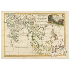
Authentic Old Map of Southeast Asia with Original Border Coloring, 1745
About the Item
Title: "Kaartje van Oost-Indien na de stelling van den Heer Guillaume de L'Isle"
Translates to "Map of the East-Indies based on the work of Mr. Guillaume de L'Isle." Guillaume de L'Isle was a prominent French cartographer known for his influential maps during the 18th century.
Published by Jacob Keizer and by Jan de Lat
Creator: Keizer, Jacob, active 1706-1750
Size: 17.10 x 24.20cm.
Description:
The map is based on the work of Guillaume de L'Isle and published in 1745, holds historical significance for its representation of the East Indies, particularly for its naming of Australia as 'Nieuw Holland.'
During the 18th century, cartographers like Guillaume de L'Isle played a pivotal role in mapping and understanding the world. Their maps were known for their accuracy and detail, contributing significantly to geographic knowledge during that era.
The designation of Australia as 'Nieuw Holland' (New Holland) on this map is noteworthy as it reflects the historical European exploration and discovery of the Australian continent by Dutch navigators. The Dutch were among the first Europeans to explore parts of Australia's western coast in the 17th century, hence the naming of the landmass as 'New Holland' on some maps during that period.
Maps from this time often also depicted various islands, regions, within the East Indies, including present-day Indonesia, Malaysia, the Philippines, and parts of Southeast Asia.
This map serves as a historical document, offering insights into the cartographic understanding of the East Indies and Australia during the 18th century, showcasing the advancements in mapping and exploration of that period.
- Dimensions:Height: 6.7 in (17 cm)Width: 9.45 in (24 cm)Depth: 0 in (0.02 mm)
- Materials and Techniques:Paper,Engraved
- Period:1740-1749
- Date of Manufacture:1745
- Condition:Very Good. Three folding lines. Study the image carefully.
- Seller Location:Langweer, NL
- Reference Number:
About the Seller
5.0
Platinum Seller
These expertly vetted sellers are 1stDibs' most experienced sellers and are rated highest by our customers.
Established in 2009
1stDibs seller since 2017
1,922 sales on 1stDibs
Typical response time: <1 hour
- ShippingRetrieving quote...Ships From: Langweer, Netherlands
- Return PolicyA return for this item may be initiated within 14 days of delivery.
More From This SellerView All
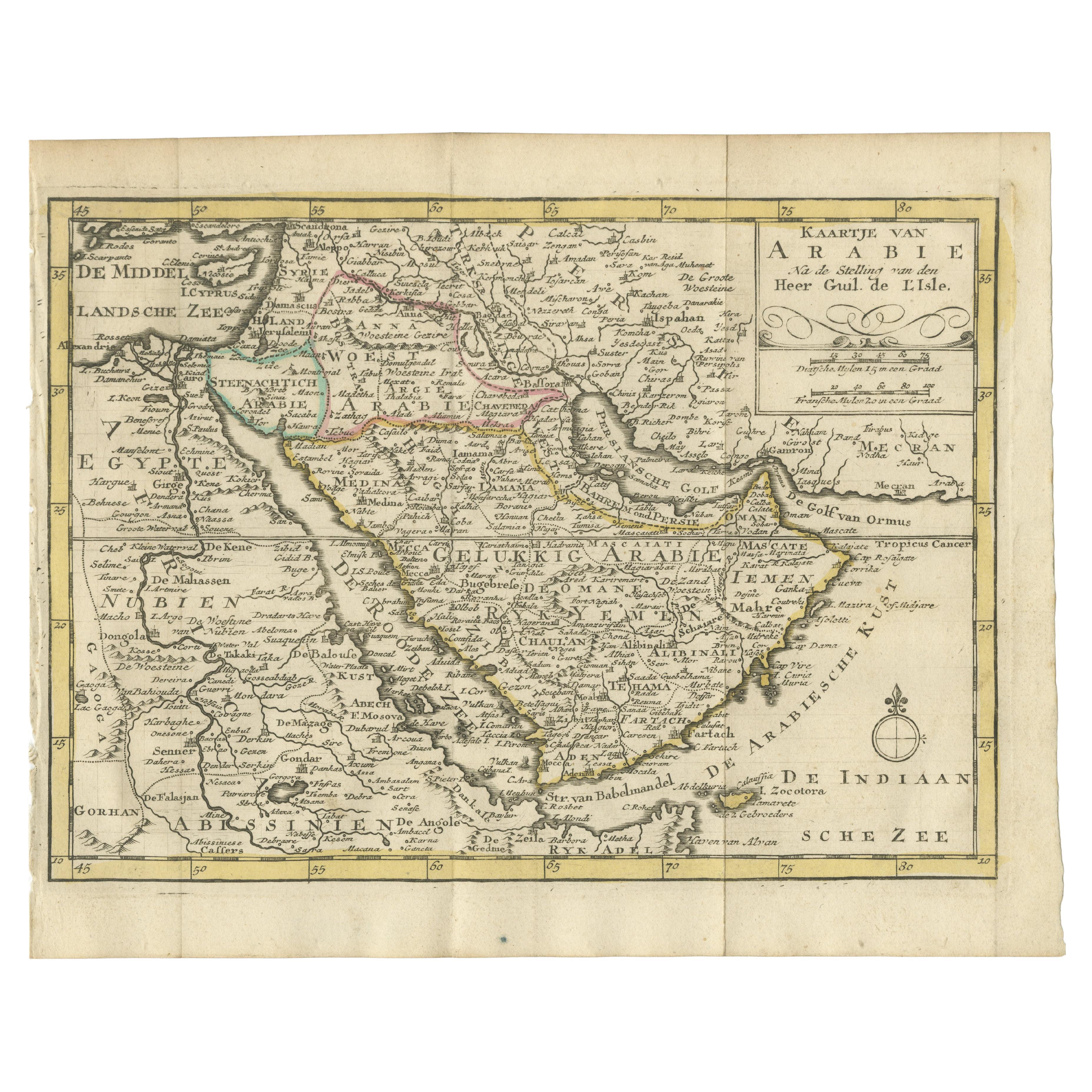
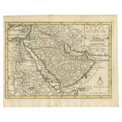
- Authentic Old Map of Arabia with Original Border Coloring, 1745Located in Langweer, NLTitle: "Kaartje van Arabië na de stelling van den Heer Guillaume de L'Isle" Translates to "Map of Arabia based on the work of Mr. Guillaume de L'Isle." Guillaume de L'Isle was a pr...Category
Antique 1740s Maps
MaterialsPaper
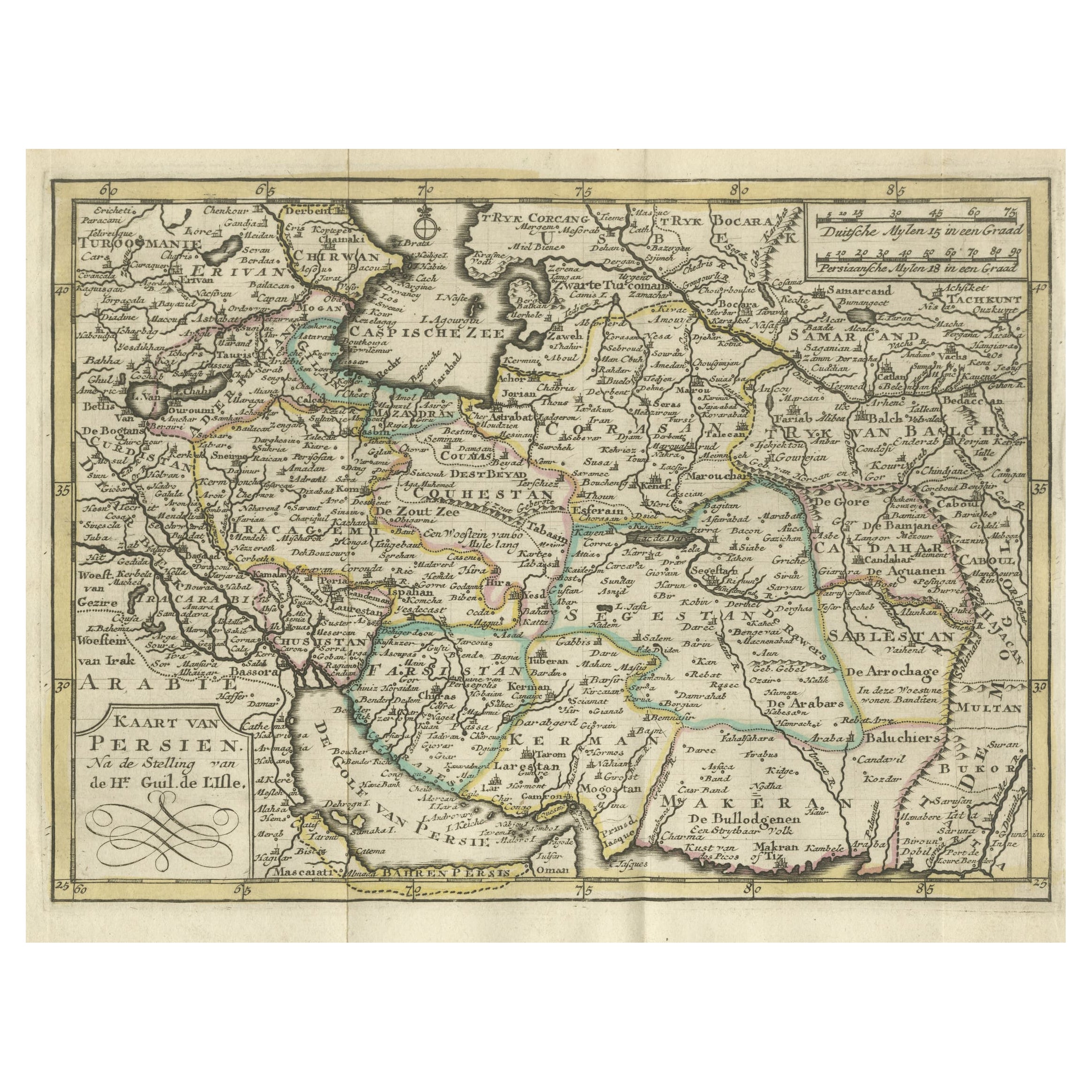
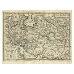
- Authentic Old Map of Persia with Original Border Coloring, 1745Located in Langweer, NLTitle: "Kaartje van Persien na de stelling van den Heer Guillaume de L'Isle" Translates to "Map of Persia based on the work of Mr. Guillaume de L'Isle." Guillaume de L'Isle was a p...Category
Antique 1740s Maps
MaterialsPaper
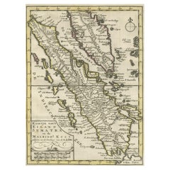
- Authentic Old Map of Sumatra, Malaysia and Singapore, 1745Located in Langweer, NLTitle: "Kaartje van't Eiland Sumatra en de Maleidse Kust gelegen na de stelling van de G. de L'Isle" Published by Jacob Keizer and by Jan de Lat Creator: Keizer, Jacob, active 1706...Category
Antique 1740s Maps
MaterialsPaper
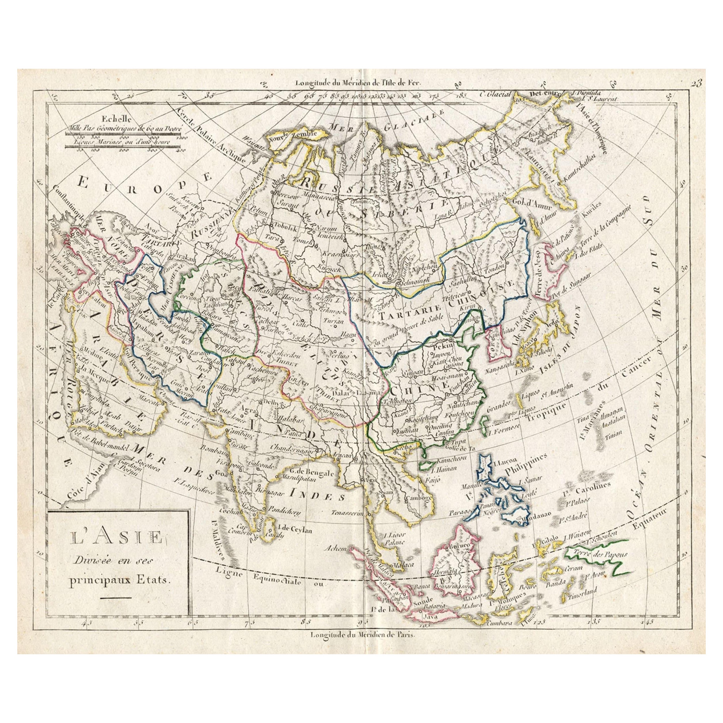
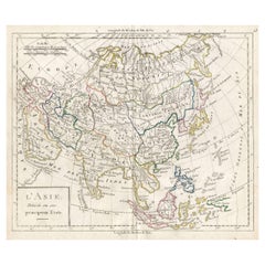
- Antique French Map of Asia with Original Border Colouring, c.1785Located in Langweer, NLAntique map titled 'L'Asie divisee en ses principaux Etats.' (Map of Asia and its principal states). This map originates from an Atlas by Didier Robert de Vaugondy or his successor D...Category
Antique 18th Century Maps
MaterialsPaper
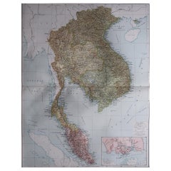
- Antique Map of India to Southeast AsiaLocated in Langweer, NLAntique map titled 'Indes en-decà et au-delà du Gange'. Original old map of India to Southeast Asia, showing India, Nepal, Bhutan, Sri Lanka (Ceylon), Myanmar (Birma), part of Indone...Category
Antique Mid-19th Century Maps
MaterialsPaper
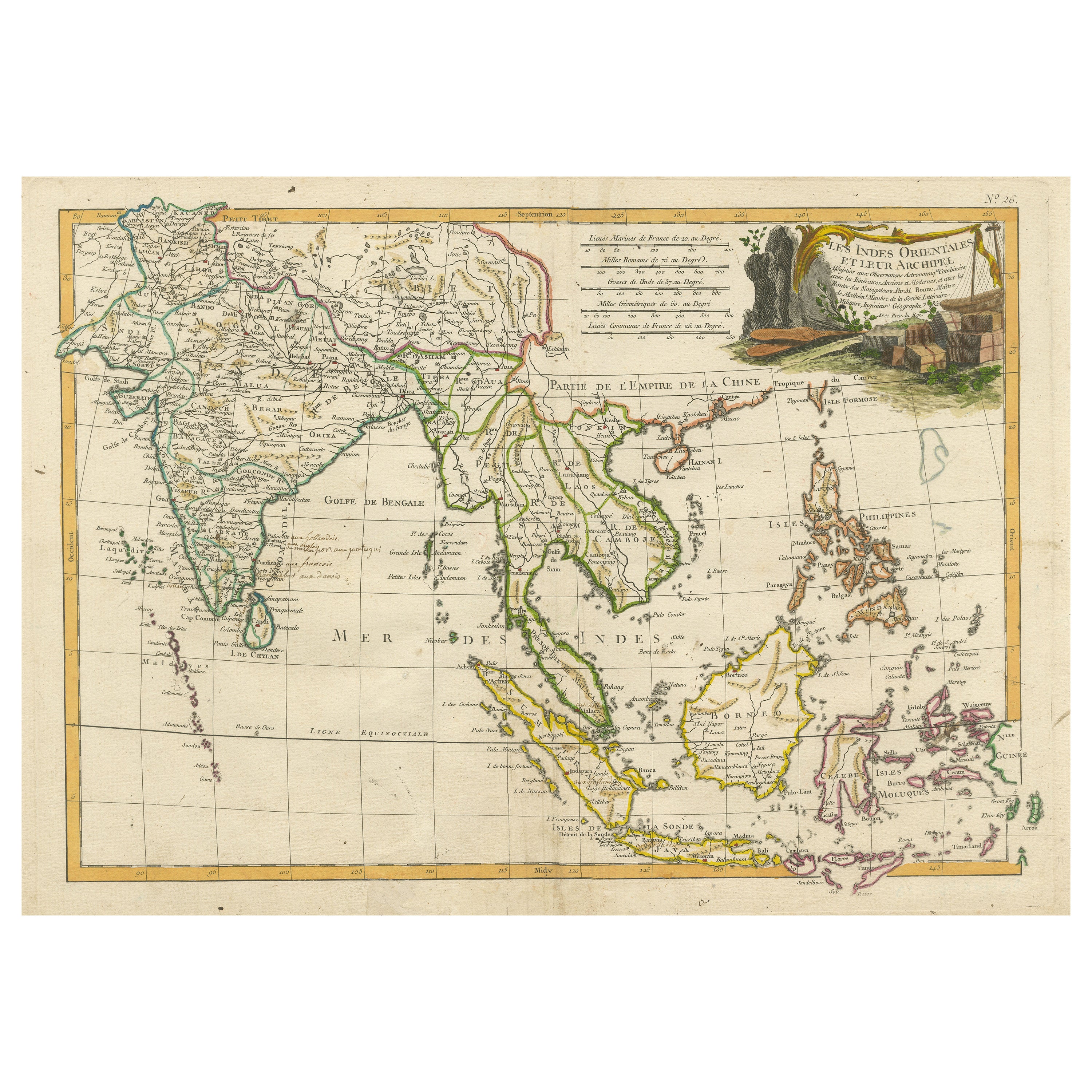
- Antique Map of Southeast Asia with Decorative Allegorical CartoucheLocated in Langweer, NLAntique map titled 'Les Indes Orientales et leur Archipel'. Old map of Southeast Asia, the Straits of Malaca, Philippines, Sumatra, Java, India etc., extending north to Canton and Ma...Category
Antique Mid-18th Century Maps
MaterialsPaper

You May Also Like
- Original Antique Map of Asia. C.1780Located in St Annes, LancashireGreat map of Asia Copper-plate engraving Published C.1780 Two small worm holes to right side of map Unframed.Category
Antique Early 1800s English Georgian Maps
MaterialsPaper

- Large Original Vintage Map of S.E Asia, with a Vignette of SingaporeLocated in St Annes, LancashireGreat map of South East Asia Original color. Good condition Published by Alexander Gross Unframed.Category
Vintage 1920s English Maps
MaterialsPaper
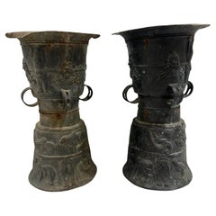
- Pair of Southeast Asian Ceremonial Rain DrumsLocated in Houston, TXPair of Southeast Asian ceremonial rain drums. Estimated that the bronze drums dates to the early 19th century. The top surface is adorned with a ceremonial star and tops are not tha...Category
Antique Early 1800s Indonesian Chinese Export Musical Instruments
MaterialsBronze
- Large Original Vintage Map of Asia, circa 1920Located in St Annes, LancashireGreat map of Asia Original color. Good condition Published by Alexander Gross Unframed.Category
Vintage 1920s English Edwardian Maps
MaterialsPaper
- Original Antique Map of South East Asia, Arrowsmith, 1820Located in St Annes, LancashireGreat map of South East Asia Drawn under the direction of Arrowsmith Copper-plate engraving Published by Longman, Hurst, Rees, Orme and Brown, 1820 Unframed.Category
Antique 1820s English Maps
MaterialsPaper
- Antique Giltwood Buddha Statue Southeast AsiaLocated in Atlanta, GAA delicately carved wood Buddha in an upright standing posture with a double Abhaya mudra. The statue displays a gilt surface with beautiful patina and some minor wear. The face was ...Category
Antique 19th Century Thai Other Sculptures and Carvings
MaterialsGold Leaf

Recently Viewed
View AllMore Ways To Browse
Map Of Ceylon
Old French Map
John Tallis Map
Australia Captain Cook
Map Zanzibar
Topographical Globe
Dan Rizzi
Formosa Vintage Map
Vincenzo Coronelli On Sale
Willem Blaeu On Sale
Antique Map Of Republic Of Texas
Antique Maps Denver
Cartier 1730
Collectible Barbies
Devonia Antique
J Karte
Map Cleveland
Union Pacific Map