Items Similar to Antique Map of South Australia by Johnston, 1882


Want more images or videos?
Request additional images or videos from the seller
1 of 5
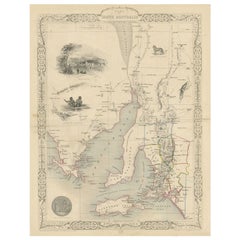
Antique Map of South Australia by Johnston, 1882
About the Item
Antique map titled 'South Australia, New South Wales, Victoria & Queensland'. Old map of Southern Australia, with an inset map of Cape York Peninsula. This map originates from 'The Royal Atlas of Modern Geography, Exhibiting, in a Series of Entirely Original and Authentic Maps, the Present Condition of Geographical Discovery and Research in the Several Countries, Empires, and States of the World' by A.K. Johnston. Published by W. and A.K. Johnston, 1882. Artists and Engravers: Alexander Keith Johnston LLD (1804-1871) was a Scottish geographer. He was a pupil of the Edinburgh engraver and mapmaker, James Kirkwood. In 1826, he joined his brother William (who would become Sir William Johnston, Lord Provost of Edinburgh) in a printing and engraving business, forming the well-known cartographical firm of W. and A. K. Johnston.
Artist: Alexander Keith Johnston LLD (1804-1871) was a Scottish geographer. He was a pupil of the Edinburgh engraver and mapmaker, James Kirkwood. In 1826, he joined his brother William (who would become Sir William Johnston, Lord Provost of Edinburgh) in a printing and engraving business, forming the well-known cartographical firm of W. and A. K. Johnston.
Condition: Fair, general age-related toning. Large split on center fold (almost in half). Please study image carefully.
Date: 1882
Overall size: 49.6 x 61.5 cm.
Image size: 0.001 x 44.3 x 57.3 cm.
Antique prints have long been appreciated for both their aesthetic and investment value. They were the product of engraved, etched or lithographed plates. These plates were handmade out of wood or metal, which required an incredible level of skill, patience and craftsmanship. Whether you have a house with Victorian furniture or more contemporary decor an old engraving can enhance your living space. We offer a wide range of authentic antique prints for any budget.
- Creator:Thomas Kitchin (Author)
- Dimensions:Height: 24.22 in (61.5 cm)Width: 19.53 in (49.6 cm)Depth: 0 in (0.01 mm)
- Materials and Techniques:
- Period:
- Date of Manufacture:1882
- Condition:
- Seller Location:Langweer, NL
- Reference Number:
About the Seller
5.0
Platinum Seller
These expertly vetted sellers are 1stDibs' most experienced sellers and are rated highest by our customers.
Established in 2009
1stDibs seller since 2017
1,933 sales on 1stDibs
Typical response time: <1 hour
- ShippingRetrieving quote...Ships From: Langweer, Netherlands
- Return PolicyA return for this item may be initiated within 14 days of delivery.
More From This SellerView All
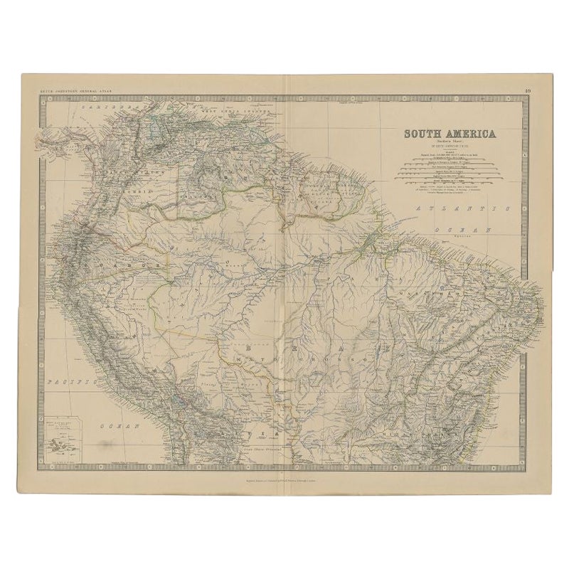
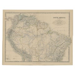
- Antique Map of South America by Johnston, 1882Located in Langweer, NLAntique map titled 'South America'. Old map of South America, with an inset map of the Galapagos Isles. This map originates from 'The Royal Atlas of Modern Geography, Exhibiting, in ...Category
Antique 19th Century Maps
MaterialsPaper
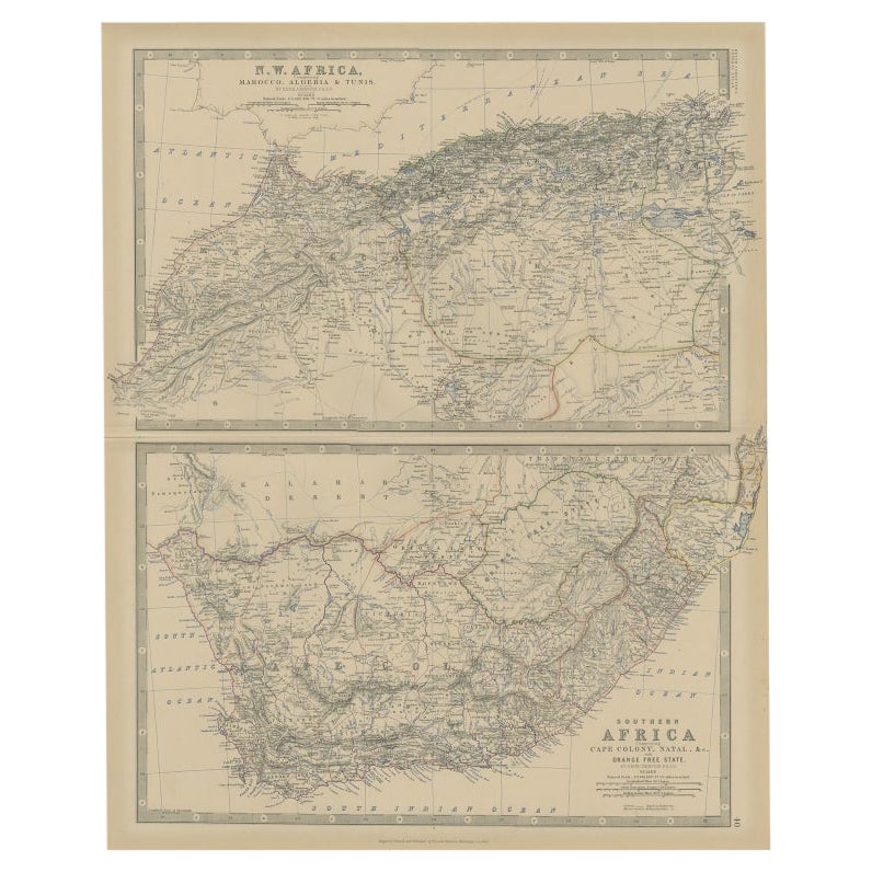
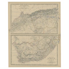
- Antique Map of North and South Africa by Johnston, 1882Located in Langweer, NLTwo antique maps on one sheet titled 'N.W. Africa, Marocco, Algeria & Tunis' and 'Southern Africa, comprising Cape Colony, Natal & c'. This map originates from 'The Royal Atlas of ...Category
Antique 19th Century Maps
MaterialsPaper
- Antique Map of South Australia by A.K. Johnston, 1865Located in Langweer, NLAntique map titled 'South Australia, New South Wales, Victoria & Queensland'. This map originates from the ‘Royal Atlas of Modern Geography’ by Alexander Keith Johnston. Published by...Category
Antique Mid-19th Century Maps
MaterialsPaper
- Antique Map of Switzerland by Johnston, 1882Located in Langweer, NLAntique map titled 'Switzerland and the Alps of Savoy and Piedmont'. Old map of Switzerland and the Alps of Savoy and Piedmont. This map originates from 'The Royal Atlas of Modern Ge...Category
Antique 19th Century Maps
MaterialsPaper
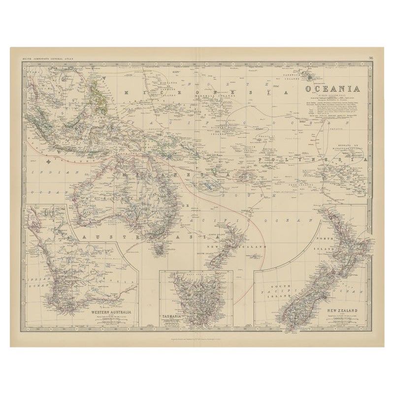
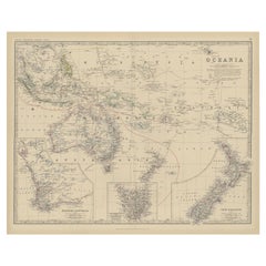
- Antique Map of Oceania by Johnston, 1882Located in Langweer, NLAntique map titled 'Oceania'. Old map of Oceania with inset maps of Western Australia, Tasmania and New Zealand. This map originates from 'The Royal Atlas of Modern Geography, Exhibi...Category
Antique 19th Century Maps
MaterialsPaper
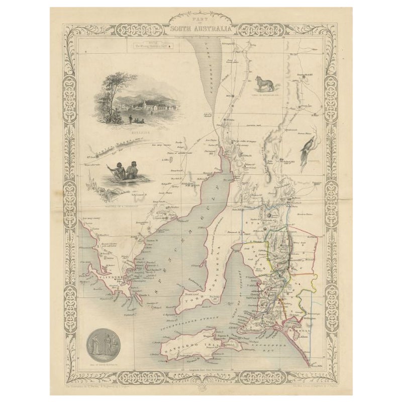
- Antique Map of South Australia by Tallis, 1851By Thomas KitchinLocated in Langweer, NLAntique map Australia titled 'Part of South Australia'. Decorative map of part of South Australia, surrounded by illustrations of Adelaide, natives on a catamaran, an Australian dog and a nymphicus bird illustrated. Originates from 'The Illustrated Atlas, And Modern History Of The World Geographical, Political, Commercial & Statistical, Edited By R. Montgomery Martin'. Published; John Tallis London, New York, Edinburgh & Dublin. 1851. Drawn and Engraved by J. Rapkin. Artists and Engravers: John Tallis (1817-1876) was a British map...Category
Antique 19th Century Maps
MaterialsPaper


You May Also Like
- Large Original Vintage Map of New South Wales, Australia, circa 1920Located in St Annes, LancashireGreat map of New South Wales Original color. Good condition Published by Alexander Gross Unframed.Category
Vintage 1920s English Edwardian Maps
MaterialsPaper
- Original Antique Map of South America. C.1780Located in St Annes, LancashireGreat map of South America Copper-plate engraving Published C.1780 Two small worm holes to left side of map Unframed.Category
Antique Early 1800s English Georgian Maps
MaterialsPaper
- Original Antique Map of South America by Thomas Clerk, 1817Located in St Annes, LancashireGreat map of South America Copper-plate engraving Drawn and engraved by Thomas Clerk, Edinburgh. Published by Mackenzie And Dent, 1817 Unframed.Category
Antique 1810s English Maps
MaterialsPaper
- Original Antique Map of South Africa, Arrowsmith, 1820Located in St Annes, LancashireGreat map of South Africa. Drawn under the direction of Arrowsmith. Copper-plate engraving. Published by Longman, Hurst, Rees, Orme and Br...Category
Antique 1820s English Maps
MaterialsPaper
- Original Antique Map of South Dakota by Rand McNally, circa 1900By Rand McNally & Co.Located in St Annes, LancashireFabulous monochrome map with red outline color Original color By Rand, McNally & Co. Published, circa 1900 Unframed Minor edge tears.Category
Antique Early 1900s American Edwardian Maps
MaterialsPaper
- Original Antique Map of South East Asia by Becker, circa 1840Located in St Annes, LancashireGreat map of South East Asia Steel engraving with original color outline Engraved by Becker Published by Virtue, circa 1840. Unframed.Category
Antique 1840s English Other Maps
MaterialsPaper


Recently Viewed
View AllMore Ways To Browse
Used Victoria Antiques
Australian Antiques
Brother Thomas
Used Victoria Furniture Antiques
Used Victoria Antique Furniture
Southern New And Used Furniture
Antique World Map Print
Antique Furniture In Australia
Alexander James
19th Century Australian Furniture
Used Furniture South Wales
Antique Prints Edinburgh
Empire Antiques Plate
Antique Prints Of Edinburgh
Thomas Alexander
Antique Scottish Wood Furniture
Scotland Antique Map
Antique Scotland Map